The share of Road Transport in total transport of India is–
Correct Answer:
(B) 80%
Till 5 January, 2025 India has 66.71 lakh kilometres approx. of the road network, which is the second largest road network in the world. In the field of transport, roadways have a leading position. About 71% of freight and 85% passenger traffic is carried by the roads.
Ques: 2
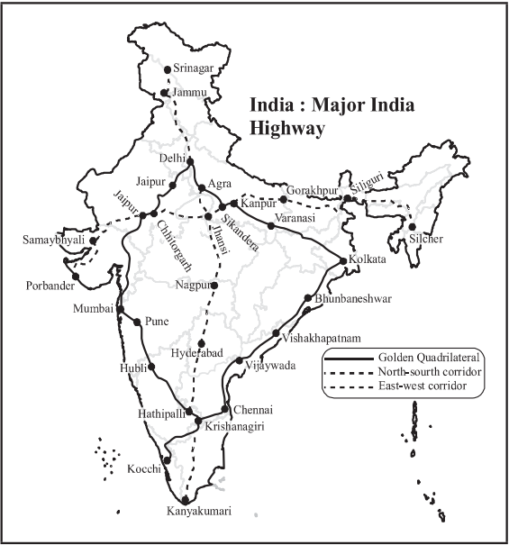
What is the Golden Quadrilateral?
Correct Answer:
(C) National Highway Project
Golden Quadrilateral is a National Highway project which was started in 2001 connecting India's four top metropolitan cities, Delhi, Mumbai, Chennai and Kolkata. Its total length is 5846 km.
Ques: 3
The proposed East-West and North-South Express Highways cross at :
Correct Answer:
(B) Jhansi
East-West Corridor connects Silchar to Porbandar and the North-South Corridor links Srinagar to Kanyakumari. They cross each other at Jhansi (Uttar Pradesh). That is why Jhansi is considered as the junction of North-South and East-West Corridors.
Ques: 4
Arrange the following cities located on the North-South corridor in a sequence from North to South. Select the correct answer using codes given below:
A. Nagpur B. Agra
C. Krishnagiri D. Gwalior
Code :
Correct Answer:
(A) B, D, A and C
The North-South corridor is the largest ongoing highway project in India. It is the second phase of the National Highway Development Project (NHDP). The correct option from North to South are Agra, Gwalior, Nagpur and Krishnagiri. Hence, (a) is the correct answer.
Ques: 5
The Pradhan Mantri Gram Sadak Yojana is :
Correct Answer:
(D) To develop community life in villages which are not well connected
Pradhan Mantri Gram Sadak Yojana (PMGSY) was launched on 25th December 2000 as a fully funded Centrally Sponsored Scheme to provide all-weather road connectivity in rural areas of the country which are not connected.
Ques: 6
Arrange the following State in descending order of their length of National Highways. Use the codes given below to select the correct answer :
(i) Arunachal Pradesh (ii) Mizoram
(iii) Nagaland (iv) Sikkim
Code :
Correct Answer:
(B) (i) (ii) (iii) (iv)
The descending order the length of National Highways in the above states is as follows :
(State) (Length of National Highways) (in km) (As by 2023)
Arunachal Pradesh - 4285
Nagaland - 1670
Mizoram - 1498
Sikkim - 709
Ques: 7
'Jawahar Tunnel' passes through which place?
Correct Answer:
(B) Banihal
Jawahar Tunnel or Banihal Tunnel is a road tunnel in the Union Territory of Jammu and Kashmir. It is maintained by Border Road Organisation (BRO). Thus, option (b) is the most appropriate answer.
Ques: 8
If you travel by road from Kohima to Kottayam, what is the minimum number of States within India through which you can travel, including the origin and the destination?
Correct Answer:
(B) 7
Analysing the shortest travel route by road from Kohima to Kottayam, the minimum number of states through which one can travel, including the origin and destination is seven i.e., Nagaland (origin), Assam, West Bengal, Odisha, Andhra Pradesh and then through either Tamil Nadu to Kerala (Kottayam), or through Andhra Pradesh to Karnataka to Kerala.
Ques: 9
Which state has maximum road density?
Correct Answer:
(B) Kerala
According to the data of the Ministry of Transport, the density of the road per 1000 sq. km. as on 31 March, 2018 is as follows :
Haryana 1131.39
Kerala 6617.03
Gujarat 1028.02
Punjab 2832.20