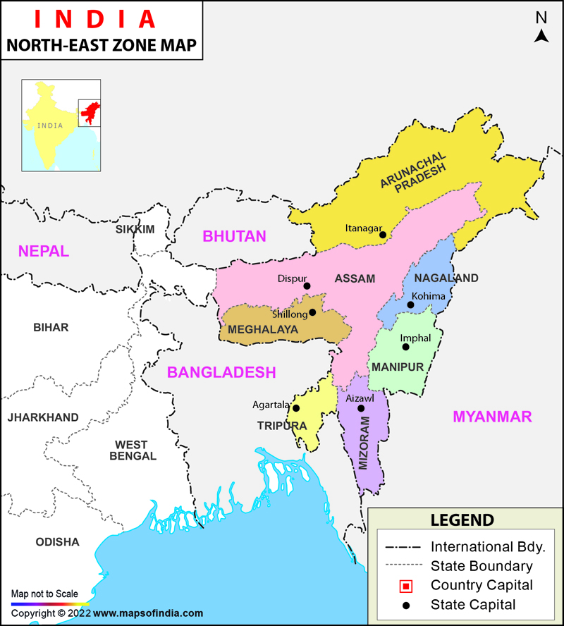
Mizoram shares border with Bangladesh and Myanmar.
Which of the statements given above are correct?
Correct Answer:
(A)
1, 2 and 3
The political map of India clearly shows that Assam shares border with Bhutan and Bangladesh. West Bengal shares border with Bhutan and Nepal and Mizoram shares border with Bangladesh and Myanmar. Thus, all the above three statements are correct. Hence (a) is the correct answer.
Ques:
2
Extension of the International boundaries of India along with their neighbouring countries in ascending order are
Correct Answer:
(B)
Nepal, Pakistan, China, Bangladesh
Extension of the International boundaries of India along with their neighbouring countries in ascending order are Nepal (1751 km) , Pakistan ( 3323 km), China (3488 km), Bangladesh ( 4096.7 km). So, the correct answer is option (b).
Ques:
3
Which one of the following states does not form the border with Bangladesh –
Correct Answer:
(C)
Manipur
West Bengal, Assam, Meghalaya, Mizoram and Tripura are the Indian states that share their borders with Bangladesh. Mymensingh, Rangpur, Khulna, Sylhet, Rajshahi and Chittagong are the six divisions of Bangladesh that are situated along the India-Bangladesh border. Manipur does not share border with Bangladesh. Manipur has an international border with Myanmar.
Ques:
4
Which one of the following Indian states does not share border with Bhutan?
Correct Answer:
(B)
Meghalaya
Bhutan and India are neighbouring countries that share border with each other. The Indian states of West Bengal, Sikkim, Assam, and Arunachal Pradesh share their borders with Bhutan. Meghalaya does not share border with Bhutan. It shares border with Bangladesh.
Ques:
5
Which one of the following Indian states does not share border with Nepal?
Correct Answer:
(C)
Assam
Nepal and India are neighbouring countries that share border with each other. The Indian states of West Bengal, Sikkim, Uttar Pradesh, Uttarakhand and Bihar share their borders with Nepal. Assam does not share border with Nepal. It shares border with Bangladesh and Bhutan.
Ques:
6
Which of the following Indian state shares maximum boundary with Myanmar?
Correct Answer:
(B)
Arunachal Pradesh
Arunachal Pradesh shares maximum boundary with Myanmar. The neighbouring countries of India are Pakistan, Afghanistan, China, Nepal, Bhutan, Myanmar, Bangladesh, Maldives and Sri Lanka. The Indian boundaries are of both types i.e., natural and man-made. India shares the longest land boundary with Bangladesh (4096.7 km) and the shortest Land boundary with Afghanistan (106 km). Indian states & UTs bordering with neighbouring countries are –
Bordering Pakistan - Ladakh, Jammu and Kashmir, Punjab, Rajasthan and Gujarat
Bordering China - Ladakh, Himachal Pradesh, Uttarakhand, Sikkim and Arunachal Pradesh
Bordering Nepal - Bihar, Uttarakhand, Uttar Pradesh, Sikkim and West Bengal
Bordering Bangladesh - West Bengal, Assam, Meghalaya, Tripura and Mizoram
Bordering Bhutan - West Bengal, Sikkim, Assam and Arunachal Pradesh
Bordering Myanmar - Arunachal Pradesh, Nagaland, Manipur and Mizoram
Bordering Afghanistan - Ladakh
Ques:
7
Which of the following states of India does not have a common border with Myanmar?
Correct Answer:
(A)
Assam
Arunachal Pradesh, Nagaland, Manipur and Mizoram are Indian states which share border with Myanmar but Assam does not share its border with Myanmar. It shares with Bangladesh & Bhutan.
Ques:
8
Which one of the following countries share the longest land frontier with India?
Correct Answer:
(D)
Bangladesh
Bangladesh forms longest land frontiers with India with 4096.7 km long international boundary. Indian states bordering Bangladesh are Mizoram, Tripura, Assam, Meghalaya and West Bengal.
Ques:
9
Which of the following states does not form its boundary with Bangladesh?
Correct Answer:
(B)
Nagaland
Nagaland does not share its border with Bangladesh. Indian states bordering Bangladesh are Assam, Meghalaya, Mizoram, Tripura and West Bengal.
Ques:
10
The boundary between India and Pakistan was demarcated by:
Correct Answer:
(D)
Radcliffe Line
The boundary between India and Pakistan was demarcated by Radcliffe line. Durand line is Between India and Afghanistan; McMahon Line is Between India and China; Maginot Line is Between France and Germany.