Classification of Ecosystems
CLASSIFICATION OF ECOSYSTEMS
Introduction
Ecosystem classification involves dividing land or water into geographic areas based on variations in ecological features, including living organisms (biotic components), non-living elements (abiotic components), their interactions, and the physical space they occupy.
Classification of Ecosystems
Natural or Man-Made Ecosystems
Natural Ecosystems: These occur naturally without
human intervention and include both terrestrial (forests, grasslands, deserts) and aquatic ecosystems (ponds, rivers, lakes, seas).
Man-Made Ecosystems: These are created by humans and include crop fields, agricultural lands, and aquariums.
Terrestrial Ecosystem or Aquatic Ecosystem
Terrestrial Ecosystems: Ecosystems found on land, such as forests, grasslands, and deserts.
Aquatic Ecosystems: Ecosystems found in water, such as ponds, rivers, lakes, and seas.
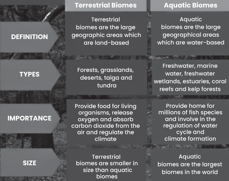
Terrestrial Ecosystems or Biomes
Terrestrial Ecosystems or Biomes
These are ecosystems found on land, covering about 28.26% of Earth’s surface.
• Determining Factors: The type of terrestrial ecosystem in an area is influenced by factors such as temperature range, precipitation, soil type and light availability.
Biomes:
The terrestrial part of the biosphere is divided into large regions called biomes, each characterized by its climate, flora, and fauna.
Examples of Terrestrial Ecosystems/Biomes:
• Tundra Biome
• Taiga/Boreal/Evergreen Coniferous Forest Biome
• Temperate Deciduous Forest Biome (North West Europe
– British Type)
• Temperate Rainforest Biome
• Sub-Tropical Deciduous Biome
• Steppe/Temperate Grassland Biome
• Temperate Deciduous Biome (Mediterranean Climate)
• Savannah/Tropical Wet or Dry Biome
• Desert Biome
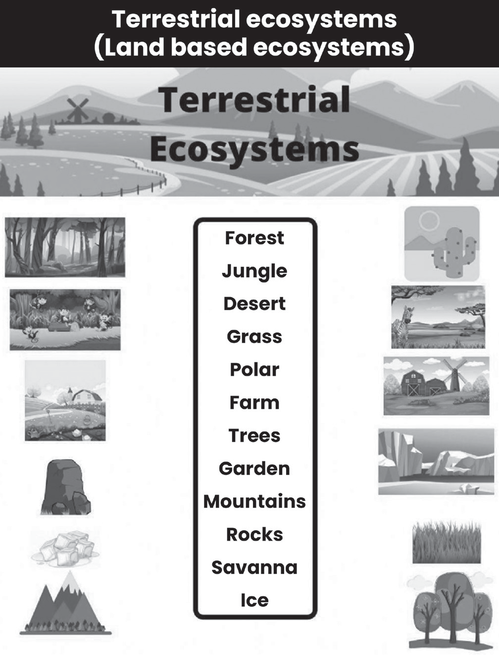
Tundra Biome
Tundra Biome (Finnish word ‘tunturi’ – ‘Treeless’)
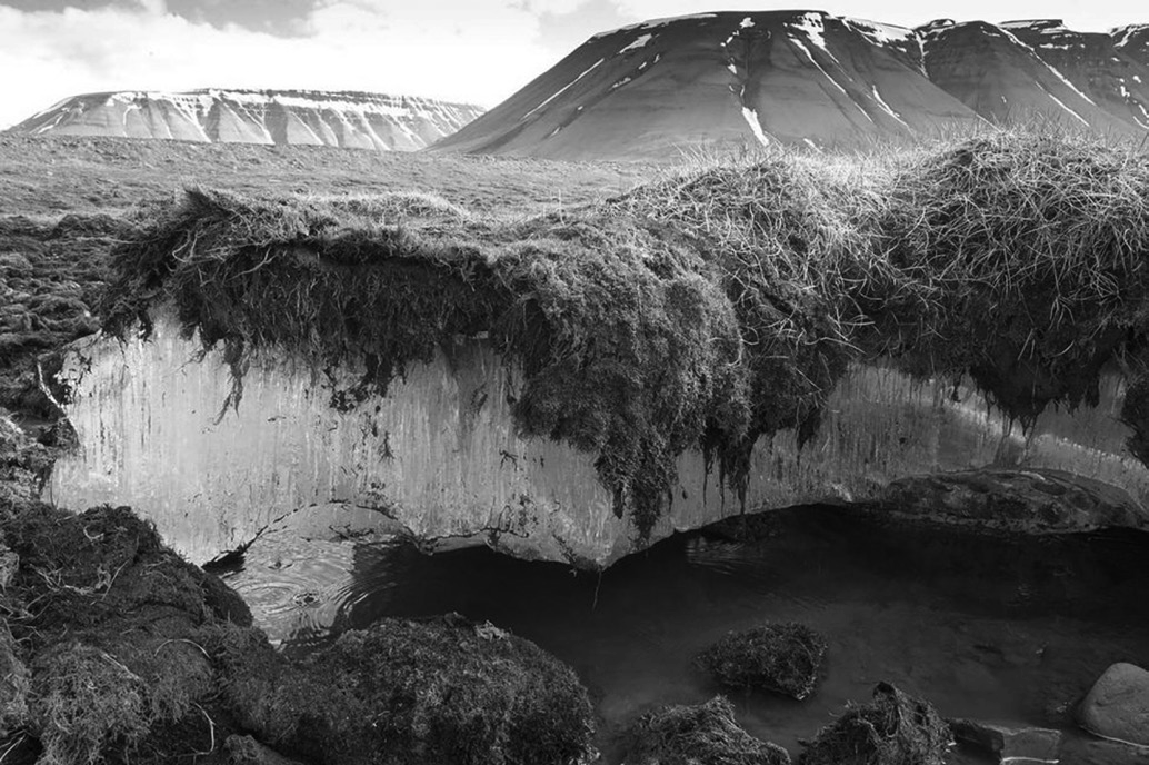
Coldest Biome: The tundra is the coldest of all biomes.
• No Trees: There are no trees due to permafrost, a permanently frozen layer on or under Earth’s surface that stays at or below 0°C for at least two consecutive years.
• Drainage Issues: Poor drainage due to lack of well- developed soil and the presence of permafrost. Decomposition is slow, leading to limited soil formation.
• Low Biodiversity: There is low biotic diversity, meaning there is less variation among and within species and biotic potential.
• Short Growing Season: The growing and reproduction season is very short. Most plants reproduce through budding and division rather than flowering.
• Nutrient Pool: Dead organic material serves as a nutrient pool. Nitrogen is added through biological fixation and phosphorus through precipitation.
• Animal Adaptations: Animals often migrate or reduce their activity to maintain homeostasis.
• Absence of Reptiles and Amphibians: These animals are nearly absent in the tundra.
Fauna (Animals) Found:
• Arctic Fox, Polar Bear, Wolves, Lemmings, Arctic Hare, Willows, Reindeers, Sandpipers, Falcons, Ravens, Pikas, Marmot, Sheep, Elk and Spring Tales etc.
Flora (Plants) Found:
• Tussock grasses, dwarf trees, small-leafed shrubs, and heaths, Mosses, Lichens, Sedges, Liverworts etc.
There are two types of tundra – arctic and alpine.
Arctic Tundra
The Arctic Tundra is a type of tundra biome found in the northern hemisphere. Here, the growing season, when plants can grow, lasts between 50 to 60 days.
The temperatures during winter average around -34°C, while in summer, they range from 3°C to 12°C. This biome receives relatively low precipitation, usually between 15 to 25 centimeters per year.
Alpine Tundra
This tundra biome is found at high altitudes, typically on mountains.
The growing season is longer than in the Arctic Tundra, ranging from 180 to 240 days.
A key difference between the Arctic and Alpine Tundra is that the Alpine Tundra has better-drained soil. This is due to the absence of a permafrost layer, steep terrain, and better-developed soil, all of which enhance drainage.
Consequently, the Alpine Tundra supports more vegetation and biodiversity compared to the Arctic Tundra, thanks to the presence of a small amount of soil.
Taiga or Boreal Biome
Taiga or Boreal Biome (Evergreen Coniferous Forest)
Location and Size:
Covers about 11% of the Earth’s landmass.
Stretches across northern latitudes, roughly between 50° N and 65° N.
The southern part is often called boreal forest, while the northern part, transitioning to tundra, is called taiga.
Climate:
Cold winters with temperatures reaching as low as -54°C.
Relatively warm summers with temperatures up to 21°C.
Moderate to high precipitation (200-600 mm annually) with infrequent droughts.
Plant Life (Flora):
Dominated by coniferous trees - pines, spruces, firs, hemlocks, and larches.
These trees are evergreen, meaning they keep their needles year-round.
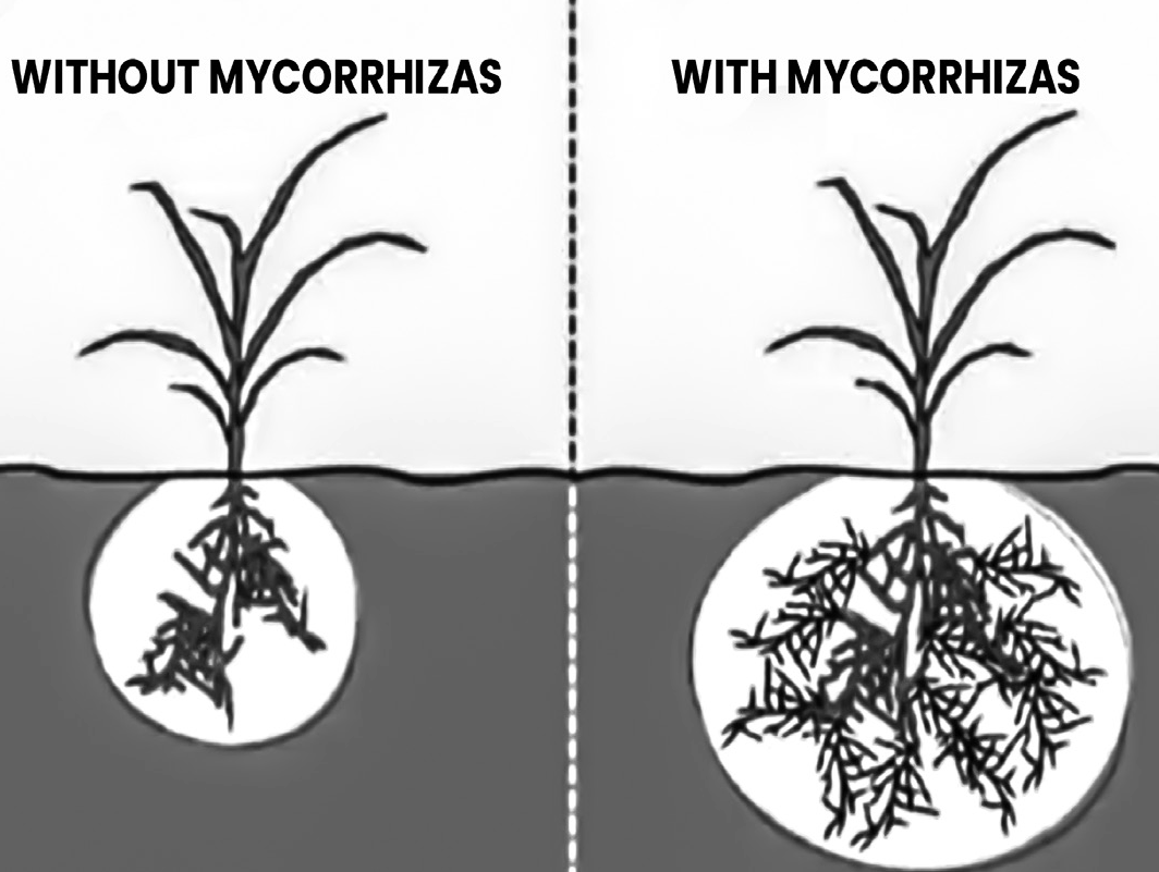
Shallow root systems adapted to work with mycorrhizal fungi for nutrient uptake from the soil.
Some broadleaf trees like aspen, birch, and willow are also present.
Soil Conditions:
Low fertility due to acidic and podzolic soil.
Nutrients are concentrated in the upper layer with decomposing organic matter.
Animal Life (Fauna):
Diverse range of mammals including caribou, moose, elk, bison, bears (black, brown), lynx, wolves, beavers, raccoons, and rodents.
• Some larger predators like Siberian tigers and wolverines may be found in specific regions.
• Amphibians like frogs (Hyla and Rana) are also present.
Temperate Deciduous Biome
Temperate Deciduous Biome
(North-Western Europe – British Type Climate)/broad-leaf forests
Climate and Location
Found in areas with warm, moist summers and cool winters.
Examples include North America, East Asia, and most of Europe (excluding some western regions).
Southern hemisphere equivalents in Patagonia (South America) and New Zealand have different dominant plant species.
Vegetation
Dominated by deciduous trees - they lose their leaves in autumn as an adaptation to survive cold winters.
This shedding helps conserve energy and prevents water loss during freezing temperatures.
Common trees include oak, maple, basswood, beech, and elm.
The southern hemisphere has Nothofagus trees instead of the typical northern deciduous species.
Soil
Similar to podzols found in the taiga, but less leached and deeper.
This allows for slightly better fertility compared to taiga soils
Temperate Rainforest Biome
Temperate Rainforest Biome
Variety Within Temperate Rainforests:
Unlike tropical rainforests, temperate rainforests can be dominated by either:
• Coniferous trees: Similar to the taiga, with evergreen needles.
• Broadleaf trees: Deciduous or evergreen, losing or keeping their leaves depending on the species.
• Mixed forests: A combination of both coniferous and broadleaf trees.
Global Distribution:
• Temperate rainforests are found in coastal regions with cool, moist climates all year round.
• Specific locations include:
• Pacific coast of North America (Northwest and Appalachians)
• Southern South America (Valdivia)
• New Zealand, southeastern Australia
• Pockets in Europe (Ireland, Norway, Iberia, Black Sea-Caspian Sea region)
• Southern Japan
Plant Life:
The consistent moisture creates a lush understory of:
• Mosses
• Ferns
• Shrubs
• Berry bushes
Depending on the specific type of temperate rainforest, the dominant tree species can vary. Some examples include:
Conifers: Douglas fir, Western red cedar, Mountain hemlock, Western hemlock, Sitka spruce, Lodgepole pine
Broadleaf trees (depending on location) - oak, maple, birch, beech
Mosses and lichens thrive in the humid environment, often growing on other plants as epiphytes (harmlessly attached).
Podzols
• Podzols are the dominant soil type in coniferous forests like the taiga.
Structure and Formation:
• They have a thin top layer rich in organic matter, formed by decomposing needles and leaves from the conifer trees.
• Below this lies a sandy or loamy layer with little to no organic matter. This is because rainwater leaches nutrients and organic materials down through the soil.
• The bottom layers may even have a build-up of these leached materials.
Challenges for Agriculture:
Due to leaching, podzols are:
• Low in moisture: Sandy or loamy composition allows water to drain quickly.
• Low in nutrients: Essential nutrients for plant growth are washed away.
• Acidic: Lack of alkaline minerals leads to a low pH, making it difficult for some plants to absorb nutrients.
• Shallow rooting zone: Limited space for plant roots due to compacted subsoil in some podzols.
Agricultural Use:
• Because of these limitations, podzols are generally poor for most agriculture.
• However, they can be used for grazing livestock in some cases.
Sub-tropical Deciduous Biome in Eastern China, South- Eastern Usa
Sub-Tropical Deciduous Biome in Eastern China, South- eastern USA
Rich Plant Life: The biome is known for its abundant and vibrant vegetation.
Vegetation Variation.
Lowlands: Evergreen broad-leaved trees - These trees keep their leaves year-round. Deciduous trees (hardwood) - These trees lose their leaves in a season, likely autumn/winter.
Highlands: Conifers - These are cone-bearing trees, often evergreen with needles, like pines and cypresses.
Favorable Growing Conditions: Unlike some other biomes, this region doesn’t experience extreme dry or cold seasons that could hinder plant growth. This allows for:
Perennial plant growth (Many plants can survive year- round without dormancy
Steppe or Temperate Grassland Biome
Steppe or Temperate Grassland Biome
Climate and Location:
• Steppes are dry, grassy plains with a semi-arid climate.
• They receive moderate rainfall (25-50 cm annually), enough for short grasses but not enough for trees or tall grasses.
• Temperate climates with distinct seasons (warm summers, cold winters) are where steppes are found.
Distribution
• Eurasian Steppe: The largest temperate grassland, stretching from Hungary to China.
• Great Plains of North America: The shortgrass prairie region, lying on the western side in the rain shadow of the Rocky Mountains (from Texas to Saskatchewan).
Plant Life:
Dominated by short grasses, fresh and nutritious, ideal for grazing animals.
Overgrazing can threaten the steppe ecosystem.
Animal Life
Steppes don’t have high animal diversity. Temperate grasslands attract herbivores of all sizes, ranging from deer and antelope to rodents. A large variety of insects, reptiles and birds also occupy this biome. Wolves, foxes and wild cats are the main predators in temperate grasslands.
Temperate Deciduous Biome (Mediterranean Climate)
Trees in this biome have small, broad leaves, are widely spaced, and are not very tall.
Areas with sufficient rainfall have low, broad-leafed evergreen trees, mainly evergreen oaks.
Fire is a significant hazard in this ecosystem, and plants have adapted to quickly regenerate after fires.
Plants struggle against heat, dry air, excessive evaporation, and prolonged droughts, making them drought-tolerant (xerophytic).
The region experiences four seasons: winter, spring, summer, and fall.
Leaves change colour and fall off in autumn, stay off in winter, and grow back in spring, helping plants survive the cold winters.
Located in mid-latitude areas between polar regions and tropics, this biome experiences warm and cold air masses, leading to four distinct seasons.
Annual precipitation ranges from 750 to 1,500 mm.
Plants in the region have thick bark to protect them from cold weather.
Trees flower and grow during the spring and summer growing seasons
Tropical Deciduous Biome
Tropical Deciduous Biome (Monsoon Climate)
This biome is characterized by seasonal rainfall and consistently warm temperatures year-round.
It has two main seasons: a dry season with little to no rain and a wet season with heavy rain. It receives up to 80 inches of rain annually, with temperatures ranging from 68°F to 77°F.
It is found on the northern and southern edges of tropical rainforests, generally between 10° and 20° latitude. Regions like parts of South America (including areas of the Amazon and southern Mexico), Southeast Asia, and India have tropical deciduous forests. Depending on the location and slight variations, this biome is sometimes called Monsoon Forest or mixed deciduous forest.
Tropical Monsoon Forests are also known as drought- deciduous forest, dry forest, dry-deciduous forest, or tropical deciduous forest.
Important species found in this biome include teak, neem, bamboo, sal, shisham, sandalwood, khair, and mulberry.
Savanna or Tropical Wet and Dry Biome
Savanna or Tropical Wet and Dry Biome
Savanna biome is a fascinating ecosystem with characteristics of both grasslands and tropical forests.
Key Differences from Grasslands
• Scattered Trees: Savannas have enough rain to support some tree growth, unlike traditional grasslands.
• Seasonal Extremes: They experience hot, wet summers with high rainfall (up to 50 inches) followed by dry seasons with very little rain (around 4 inches per month).
Impact of Seasons
• Fires: This dry season creates perfect conditions for frequent fires, both natural (lightning strikes) and human- controlled (land management).
• Adaptations: Plants and animals in the savanna have adapted to these seasonal changes:
• Plants: Grasses grow fast during the wet season and turn brown to conserve water during the dry season. Trees may store water in their roots and lose leaves during dry periods. Some plants are fire-resistant.
• Animals: Many are herbivores that migrate across the savanna, relying on speed and herd numbers for protection in the vast open areas. Predators need good eyesight and speed for hunting. Camouflage is crucial for both predators and prey to survive.
Flora and Fauna
• Vegetation: A mix of tall grasses, shrubs, acacia trees, and baobab trees.
• Animals: Rich in diversity, including large mammals (elephants, giraffes, zebras, rhinos, lions, leopards, cheetahs), primates (baboons), reptiles (crocodiles, snakes), birds (ostriches), and insects (ants, termites).
Tree Adaptations
• Deciduous: Shedding leaves in the dry season to minimize water loss.
• Broad Trunks: Storing water for survival during droughts.
• Umbrella-shaped: Minimizing wind resistance.
Do You Know?
Importance of fire in savanna ecosystems Fire as a Management Tool:
• Traditionally, cattle farmers use controlled burns to manage the savanna.
Benefits of Fire:
• Stimulates new growth of nutritious grasses for grazing animals.
• Controls the population of parasitic ticks that can harm livestock.
• Manages the growth of unwanted thorny shrubs.
Importance of Fire for the Ecosystem:
• Without periodic fires, many savannas would be fundamentally different.
• Fires are a natural part of the savanna cycle and essential for maintaining the health of the ecosystem.
• Controlled burning is a key management activity in protected areas to preserve the savanna.
Fire and Carbon Cycle:
• The fires in savannas are considered carbon-neutral.
• They primarily burn dry grasses that regrow quickly.
• The carbon dioxide released during the fire is reabsorbed by the new grass growth in the following year. This creates a closed loop with minimal net impact on atmospheric carbon.
Tropical Rainforest Biome
Tropical Rainforest Biome
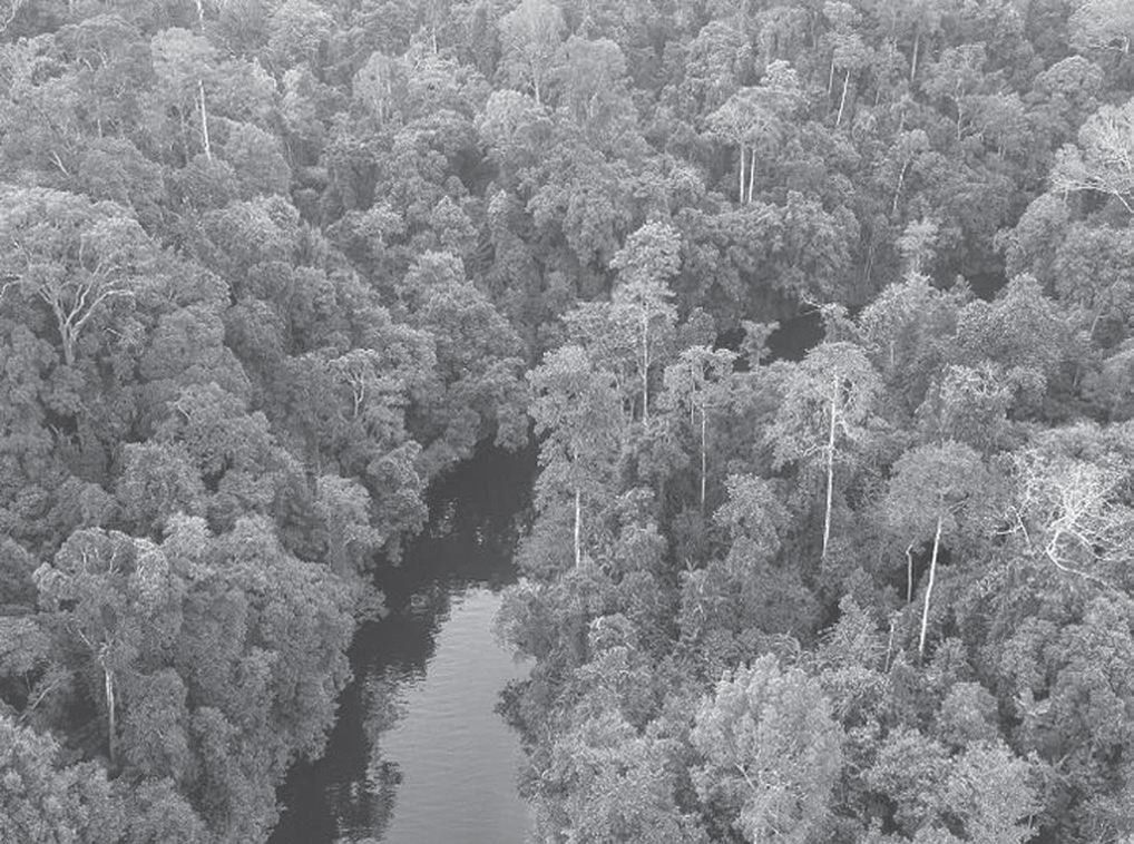
Tropical rainforests are rainforests found in regions with a tropical rainforest climate, characterized by:
• No dry season.
• Monthly precipitation averaging at least 60 mm.
• Also known as lowland equatorial evergreen rainforests.
Geographic Range:
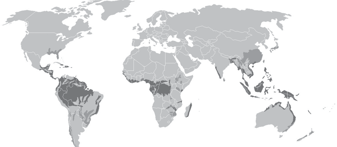
• Primarily located between 10 degrees north and south of the equator.
• Falls within the 28-degree latitudes, specifically between the Tropic of Cancer and Tropic of Capricorn.
• Notable regions include the Amazon Basin in South America, the Congo Basin in Africa, and Southeast Asia.
Classification
• According to the World Wildlife Fund’s biome classification, tropical rainforests fall under:
• Tropical moist broadleaf forests or tropical wet forests.
• This classification includes more extensive seasonal tropical forests as well.
Climate and Vegetation
• Climate: Characterized by high temperatures and abundant rainfall throughout the year.
• Vegetation: Dominated by a variety of evergreen trees such as mahogany, ebony, and dyewoods.
• Coastal areas and brackish swamps feature mangrove forests.
• Vegetation exhibits a distinctive layered structure (canopy), where plants compete for sunlight.
• Common flora includes epiphytes (plants growing on other plants).
Unique Features
The consistent climate and high levels of precipitation support a dense and diverse array of plant and animal life.
The canopy structure creates different habitats at various levels, supporting a rich biodiversity.
Mangrove forests in coastal regions act as crucial buffers against coastal erosion and provide unique habitats for many species.
In recent years, the rainforest has been at risk due to deforestation and burning. 17% of the whole rainforest and around 20% of the Brazilian rainforest have been cut down.
Desert Biome
Desert Biome
The desert biome makes up about one-fifth of the Earth’s surface.
The soil in deserts can be sandy, gravelly, or stony.
Deserts receive very little rainfall, usually no more than 50 centimeters (20 inches) a year.
The plants in deserts are adapted to survive with very little water.
Common desert plants include cacti, thorny bushes, long- rooted grasses, and dwarf acacias.
Desert shrubs have long roots to find moisture and groundwater, and they are spaced out to maximize water collection.
Desert plants often have few or no leaves, and the leaves they do have are waxy, leathery, hairy, or needle-shaped to reduce water loss.
Many grasses and herbs have seeds with thick, tough skins to protect them while they lie dormant.
Aquatic Ecosystems
Aquatic Ecosystems
Aquatic ecosystems are environments where living organisms (biotic components) interact with their non-living surroundings (abiotic components).
Components of Aquatic Ecosystems
• Biotic components: Living organisms, like plants, animals, and microbes.
• Abiotic components: Non-living chemical and physical factors.
Types of Aquatic Environments
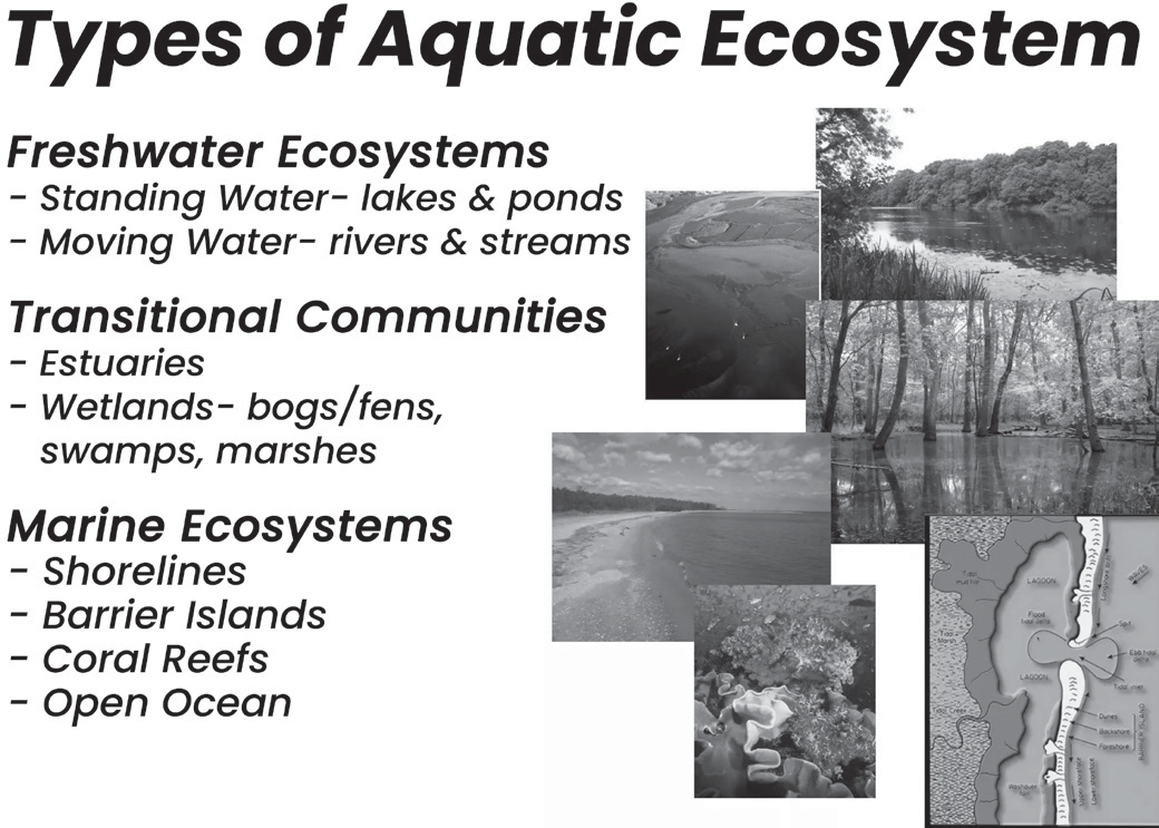
• Marine environments: Saltwater ecosystems like seas and oceans.
• Freshwater systems: Lakes, rivers, ponds, and wetlands.
Adaptations of Organisms
The plants and animals in these environments have adaptations that allow them to thrive in water.
Importance of Abiotic Factors:
Various non-living factors play a crucial role in shaping aquatic habitats. These include:
• Temperature: Affects water chemistry, organism survival, and metabolism.
• Light: Important for photosynthesis by aquatic plants and influences the distribution of organisms in the water column (depth).
• PH: Affects the availability of nutrients and can influence organism survival.
• Water quality: Includes factors like clarity, pollution levels, and oxygen content, which are vital for aquatic life.
• Dissolved gases and salts: Oxygen is essential for respiration, while other dissolved minerals and salts are important for various biological processes.
• Turbidity (water clarity): Affects light penetration and can impact feeding and predator-prey interactions.
• Alkalinity: Water’s buffering capacity to resist changes in pH.
• Depth: Light availability, temperature, and pressure all vary with depth, creating different habitats for aquatic organisms.
• Areal distribution: The physical layout and size of the water body also influences the habitat.
Types of Aquatic Ecosystems based on Salinity
• Freshwater Ecosystems (Low Salinity - < 0.5 ppt):
• Subset of Earth’s aquatic environments.
• Examples: lakes, ponds, rivers, streams, springs, wetlands.
• Lower salt content compared to marine ecosystems.
• Further classification within freshwater habitats (e.g., ponds, lakes) based on factors like temperature, light penetration, and vegetation.
• The study of freshwater ecosystems is called limnology.
• Freshwater Subtypes:
• Lentic Ecosystems: Still or stagnant water bodies like lakes, ponds, swamps, and bogs.
• Lotic Ecosystems: Flowing water bodies like rivers, springs, and creeks.
• Brackish Water Ecosystems (Medium Salinity - 0.5 to 35 ppt):
• Water bodies with salinity between freshwater and marine environments.
• Examples: estuaries, salt marshes, mangrove swamps, and forests.
• Marine Ecosystems (High Salinity - 35 ppt or above):
• Water bodies with high salt concentration.
• Examples: shallow seas and open oceans.
Key Points:
Salinity is a major factor in determining the types of organisms that can thrive in an aquatic ecosystem.
Freshwater ecosystems support a wide variety of life that cannot tolerate high salt content.
Brackish water ecosystems are a unique blend of freshwater and marine influences, creating a special habitat for adapted species.
Marine ecosystems, with their vastness and high salinity, are home to a diverse range of marine life.
Abiotic Components of Aquatic Ecosystem
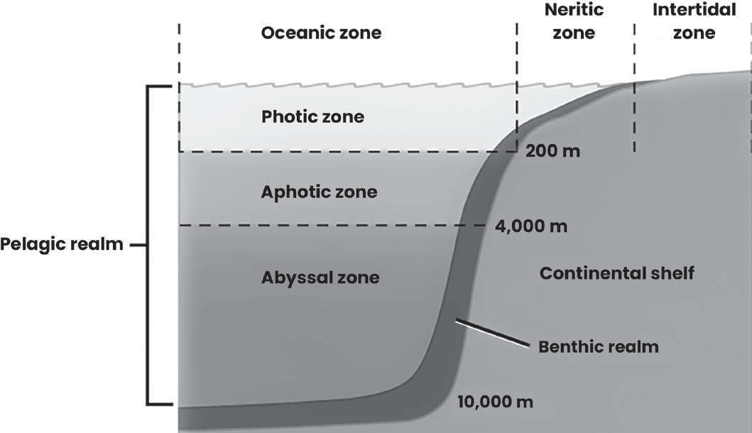
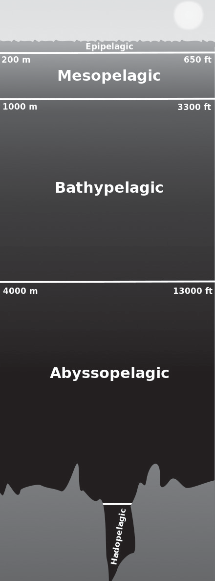
Marine Zonation Based on Range in Depth
• Pelagic Zone (the open ocean water away from the shore or seabed)
• Also known as the “deserts of the sea” due to lower productivity compared to coastal areas.
• Divided into vertical zones based on light availability.
• Home to a variety of organisms adapted to different depths and light conditions.
Subzones of the Pelagic Zone
• Epipelagic (Sunlit Zone):
• Depth: Surface to 200 meters.
• Receives enough sunlight for photosynthesis by phytoplankton (plant plankton), the base of the marine food chain.
• Most primary production (creation of organic matter) in the ocean occurs here.
• Mesopelagic (Twilight Zone):
• Depth: 200 - 1,000 meters.
• Limitedlight penetration, insufficientfor photosynthesis.
• Diverse range of fish and unique behaviors found here.
• Estimated to hold 90% of the global fish biomass.
• Bathypelagic (Midnight Zone):
Depth: 1,000 - 4,000 meters.
• No sunlight reaches this depth.
• Organisms rely on bioluminescence (emitting light) and falling organic matter (detritus) from above for food.
• Relatively stable environment with minimal currents.
• Abyssopelagic or Abyssal Zone (Lower Midnight Zone):
• Depth: 4,000 - 6,000 meters.
• Pitch black with extreme pressure and cold temperatures.
• Adapted organisms rely on detritus sinking from above for sustenance.
• Common adaptations include slow metabolism, bioluminescence, large mouths for capturing food, and flexible stomachs to accommodate infrequent meals.
• Hadopelagic Zone:
• Depth: 6,000 meters to the ocean floor (deepest trenches and canyons).
• Similar characteristics to the abyssal zone, but limited information due to the extreme depths.
• The Benthic Zone
Location: Starts at the shoreline and extends to the deepest ocean trenches, encompassing the entire seafloor.
Physical Characteristics: Diverse depending on location (shallow shelves, deep trenches, etc.) but the ecological properties are most significant.
Life in the Benthic Zone:
Benthos: The term for organisms living on or in the ocean floor sediment.
Diversity: Home to a vast majority (98%) of marine species.
Food Web: Primarily consists of scavengers and detritivores, feeding on dead organic matter sinking from above.
Marine Zonation Based on Sunlight Penetration
Photic Zone (Euphotic Zone):
• The part of the ocean where enough sunlight reaches for photosynthesis to occur.
• Depth: Varies depending on water clarity. Can range from a few centimeters in murky water to around 200 meters in clear open oceans.
• Importance: High rate of photosynthesis by phytoplankton, the base of the marine food chain. Abundant plant and animal life.
Disphotic Zone (Twilight Zone)
• The zone between the photic and aphotic zones.
• Depth: Starts from around 200 meters and extends down to 1000 meters.
• Sunlight Penetration: Limited sunlight reaches this zone.
• Photosynthesis: Very low rate of photosynthesis due to limited light.
Aphotic Zone
• The deepest zone where no sunlight or where less than 1% of sunlight penetrates.
• It starts at depths below 1,000 meters and can reach depths of almost 20,000 feet.
• The aphotic zone is also known as the midnight zone.
• Light: Essentially complete darkness. Bioluminescence (organisms creating their own light) is the main source of light.
• Food Source: Detritus (dead organic matter) sinking from above is the primary food source for organisms here.
• Temperature: The temperature is close to freezing and gets colder with depth.
What is Dissolved Oxygen (DO)?
The amount of oxygen gas dissolved in water.
A crucial measure of water quality, indicating an aquatic environment’s ability to support life.
Average DO Levels:
Freshwater: Around 10 parts per million (ppm) by weight.
This is significantly lower (150 times) than the oxygen concentration in the same volume of air.
Sources of DO in Water:
• Diffusion: Transfer of oxygen from the air-water interface.
• Photosynthesis: Aquatic plants produce oxygen as a byproduct.
DO Loss in Water:
• Respiration: Aquatic organisms (fish, decomposers, zooplankton) consume oxygen for respiration.
• Decomposition: Breakdown of dead organic matter by decomposers also uses up oxygen.
• Temperature: Warmer water holds less dissolved oxygen.
• Warmer water molecules have more kinetic energy (movement), making it harder for oxygen molecules to stay dissolved.
• Higher temperatures also increase decomposer activity, further depleting oxygen.
Impact of Low do Levels
• When DO falls below 3-5 ppm, many aquatic organisms can die due to oxygen deprivation.
In essence, maintaining sufficient DO levels is vital for healthy aquatic ecosystems. Human activities like pollution and global warming can increase water temperature and decrease DO levels, harming aquatic life.
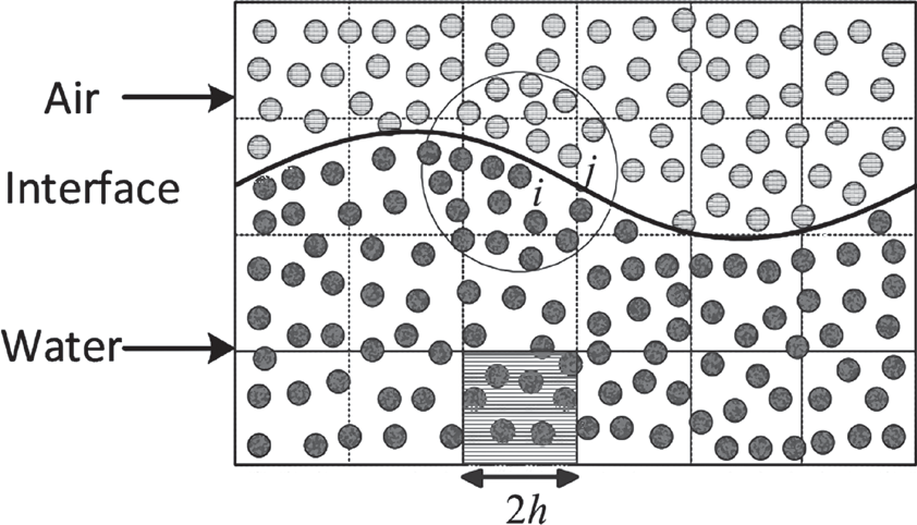
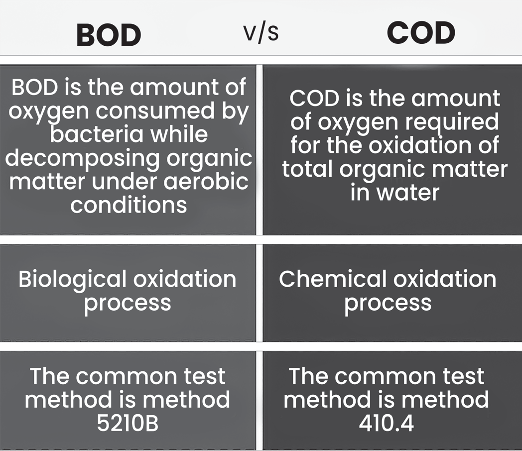
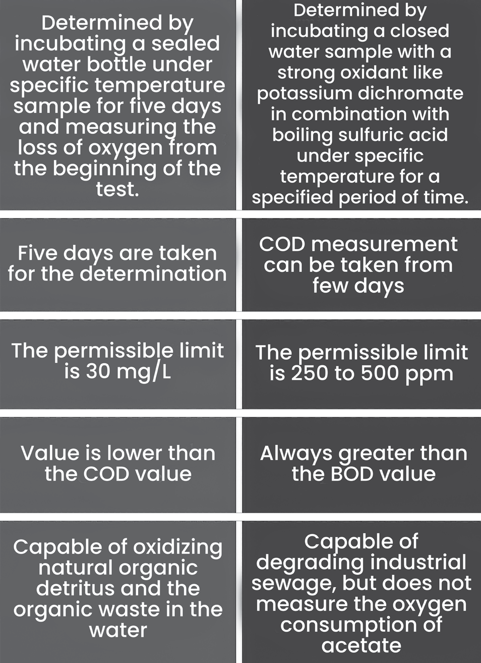
Winterkill
• Winterkill is the loss of fish and other aquatic organisms in a body of water during winter, primarily due to lack of dissolved oxygen.
• Cause: Reduced oxygen production and increased oxygen consumption.
Factors Contributing to Winterkill
• Reduced Oxygen Production:
• Limited Photosynthesis: During winter, ice and snow cover can limit sunlight reaching submerged plants and algae, which are responsible for oxygen production through photosynthesis.
• Increased Oxygen Consumption:
• Decomposition: As organic matter (dead plants, animals) decomposes, bacteria consume oxygen in the process.
• Fish Respiration: Fish and other aquatic organisms continue to use oxygen for respiration throughout winter.
Impact on Aquatic Life
• Low Oxygen Levels: When oxygen levels become depleted, fish and other organisms become stressed and can die from suffocation.
• Shallow Lakes Most Susceptible: Smaller, shallower bodies of water are more prone to winterkill because they have less volume for oxygen to be dissolved in and are more easily affected by temperature changes.
Temperature
Temperature Tolerance:
Aquatic Organisms:
• Generally, have a narrow temperature tolerance limit
(also called narrow ecological amplitude).
• This means they can only survive within a relatively small temperature range.
Terrestrial Organisms:
• Often have a wider temperature tolerance limit.
• They can adapt to a broader range of temperatures.
Reasons for the Difference
Water’s Heat Capacity: Water has a high heat capacity, meaning it absorbs and releases heat slowly. This creates a more stable temperature environment for aquatic organisms, but also makes it harder for them to adjust to rapid temperature changes.
Behavioral Adaptations: Terrestrial organisms can often move to find more suitable temperatures if their environment becomes too hot or cold. Aquatic organisms, especially those living in deeper water, have fewer options for behavioral temperature regulation.
Impact of Temperature Changes
Even small changes in water temperature can significantly impact aquatic organisms.
Changescan dis rupt physiological processes, reproduction, and feeding behavior.
In extreme cases, temperature changes can lead to death.
Biotic Components of Aquatic Ecosystem
Marine Life:
All animals, plants, and microbes living in saltwater oceans and seas.
Play crucial roles in maintaining the health and function of these ecosystems.
Classification of Marine Biota
• Pelagic vs. Benthic Environments:
• Pelagic: Organisms living in the open water column (water above the seafloor).
• Benthic: Organisms living on or within the seafloor sediment.
• Someo rganismsmay transition between these environments during their life cycle.
Types of Marine Organisms based on Habitat
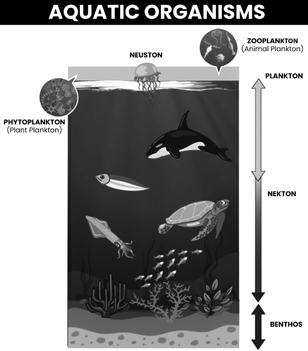
• Neuston:
• Organisms living at the water surface (e.g., some insects, algae)
• Periphyton:
• Microscopic organisms attached to submerged surfaces (e.g., algae, bacteria)
• Plankton:
• Microscopic or drifting organisms in the water column:
• Phytoplankton: Plant plankton (e.g., algae) - primary producers, base of the food chain.
• Zooplankton: Animal plankton (e.g., protozoans, small crustaceans) - consumers, feed on phytoplankton.
• Nekton:
• Strong swimmers that can move independently of currents (e.g., fish, squid, whales) - top predators in the food chain.
• Benthos:
• Organisms living on or in the seafloor:
• Mostly invertebrates (e.g., sea stars, crabs, worms, clams)
Lake Ecosystem
Lake Ecosystem
A lake ecosystem includes both living organisms (plants, animals, and micro-organisms) and non-living components (physical and chemical interactions).
These ecosystems are examples of lentic (still water) ecosystems.
Types of lakes include ponds (small lakes) and water reservoirs.
Over time, lakes can fill with organic sediments through a process called succession, often accelerated by human activities, known as eutrophication.
•
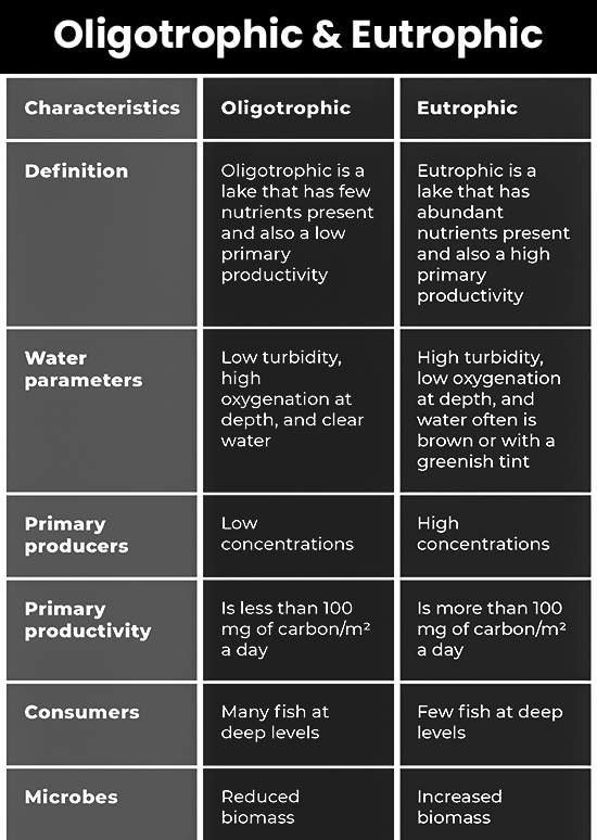
Lakes can be classified based on nutrient levels:
• Oligotrophic: Low nutrient levels.
• Mesotrophic: Moderate nutrient levels, clear water with submerged plants.
• Eutrophic: High nutrient levels, promoting algae and aquatic plant growth.
• Most Indian lakes are eutrophic or mesotrophic due to nutrient input from their surroundings and organic waste.
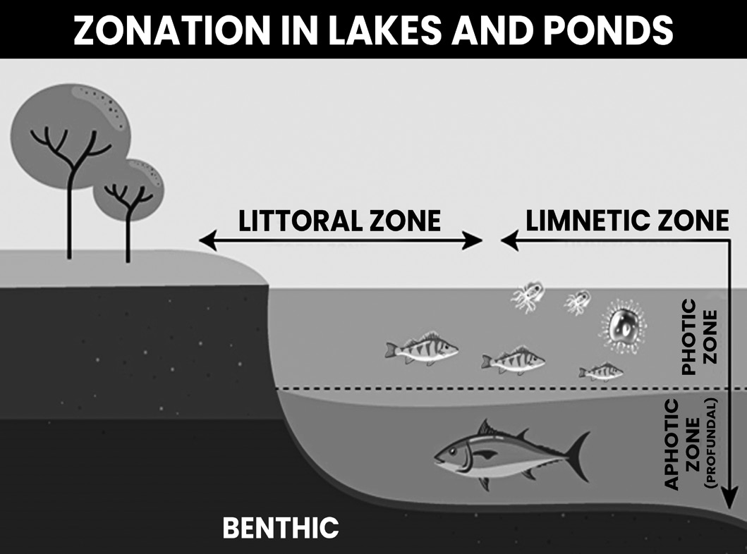
Zonation in Lakes and Ponds
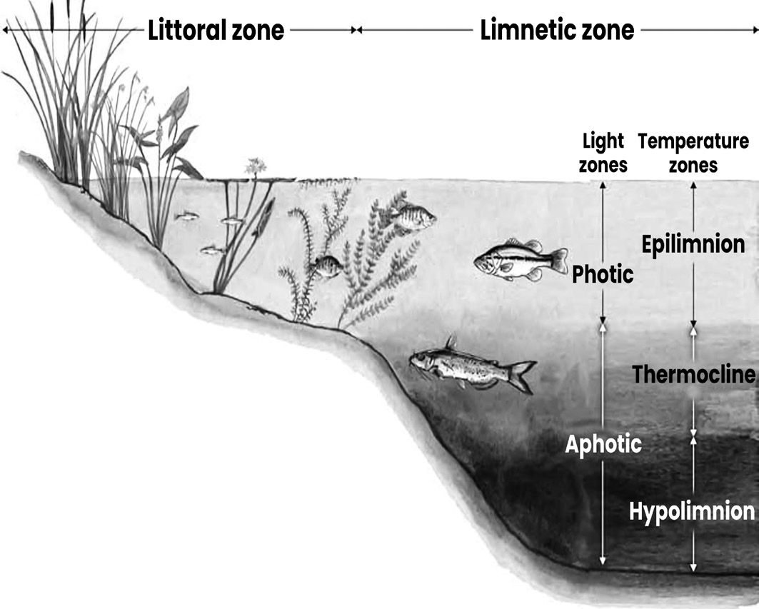
The Littoral Zone
• The littoral zone is the part of a lake or pond that is near
the shore.
• Extent: It extends from the dry land to the open water. This zone can vary in width.
Characteristics:
• Oligotrophic (young) ponds: Have narrow littoral zones because of steep sides.
• Eutrophic (old) ponds: Have wide littoral zones due to gently sloping shorelines and sides.
Nutrient Levels: The littoral zone is shallow and receives a lot of nutrients from runoff and pollution.
Biological Abundance: High nutrient levels promote the growth of aquatic plants and algae. Common inhabitants include cattails, reeds, crawfish, snails, insects, zooplankton, and small fish.
The Limnetic Zone
• The limnetic zone is the open water area of a lake or pond, away from the shore.
Size:
• Oligotrophic (young) lakes/ponds: This zone is larger because these water bodies have deeper and clearer water.
• Eutrophic (old) lakes/ponds: This zone is smaller due to shallower and nutrient-rich water.
Sections:
Euphotic Zone/Epilimnion:
• Location: The upper portion of the limnetic zone, near the surface.
• Sunlight: Receives sunlight, making it a productive area for photosynthesis.
• Temperature: Warm water region.
• Life: Algae and aquatic plants thrive here, along with dense fish populations due to higher oxygen levels from air contact.
• Depth: The euphotic zone ends where sunlight no longer penetrates the water.
The Profundal Zone
• Location: Below the euphotic zone (where sunlight penetrates) and thermocline (water temperature boundary).
• Sunlight: No sunlight reaches this zone.
• Water Characteristics:
• Deep.
• Cold temperatures.
• Lower oxygen levels, especially during certain times of the year.
Factors Affecting Profundal Zone Size
• Lake Age: Older lakes often have larger profundal zones due to sediment accumulation over time.
• Water Clarity: Clearer water allows light to penetrate deeper, potentially reducing the size of the profundal zone.
Life in the Profundal Zone
• Generally, less diverse compared to the littoral zone due to the lack of sunlight and limited oxygen.
• Some fish species adapted to low-light and low- oxygen conditions may be present.
• Detritivores (organisms that feed on dead organic matter sinking from above) can also be found here.
The Benthic Zone
• Location: The bottom sediment of the lake or pond, consisting of organic material and soil.
• Function: Often referred to as the lake’s digestive system due to its role in decomposition:
• Bacteria break down organic matter from dead plants, algae, fish waste, and animal waste.
• The amount of decomposition depends on the organic matter present in the pond.
• Decomposition Processes:
• Aerobic Decomposition: Preferred method, occurring in the presence of oxygen.
• Faster process with less harmful byproducts.
• Anaerobic Decomposition: Occurs in the absence of oxygen.
• Slower process and can produce methane gas (a greenhouse gas) and other potentially harmful byproducts.
• Impact of Lake Age: The benthic zone typically increases in size as the lake ages due to the accumulation of sediment over time.
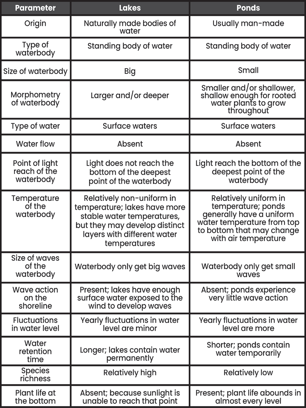
Difference Between Lake and Pond
Wetland Ecosystem
Wetland Ecosystem
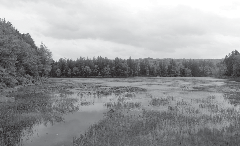
Wetlands are unique ecosystems saturated by water either permanently or seasonally. This water saturation results in anoxic (oxygen-free) conditions, especially in the soils.
Characteristics:
• The distinguishing feature is the presence of aquatic plants that thrive in anoxic, hydric soils.
• Wetlands are among the most biologically diverse ecosystems, providing habitat for a wide variety of plant and animal species.
Assessment and Conservation:
Methods have been developed globally to assess wetland functions and health. These methods help in conserving wetlands by raising public awareness about their importance.
Global Distribution:
Wetlands are found on every continent. The water in wetlands can be freshwater, brackish, or saltwater.
Types of Wetlands
By Vegetation:
Marshes: Dominated by emergent vegetation like reeds, cattails, and sedges.
Swamps: Dominated by woody vegetation such as trees and shrubs.
By Water Source:
Tidal Wetlands: Influenced by oceanic tides.
Estuaries: Mixture of tidal and river waters.
Floodplains: Water from overflowed rivers or lakes.
Springs, Seeps, and Fens: Groundwater discharge onto the surface.
Bogs and Vernal Ponds: Rainfall or meltwater.
Complex Wetlands:
Some wetlands have multiple types of plants and water sources, making classification challenging.
Major Wetlands:
Examples include the Amazon River basin, the West Siberian Plain, the Pantanal in South America, and the Sundarbans in the Ganges-Brahmaputra delta.
Ecosystem Services
Wetlands provide numerous benefits:
Water Purification: Filtering pollutants.
Groundwater Replenishment: Maintaining water levels.
Shoreline Stabilization: Protecting against erosion.
Storm Protection: Buffering against storms.
Flood Control: Storing excess water.
CarbonProcessing: Fixation,decomposition, and sequestration.
Support for Biodiversity: Habitat for diverse species.
Biodiversity and Products:
• Wetlands are rich in biodiversity and provide various products, enhancing their ecological and economic value.
Environmental Impact
• Wetlands are highly susceptible to environmental degradation.
• They can act as both sources and sinks of carbon, playing a significant role in climate change mitigation.
• Some wetlands emit methane and nitrous oxide, potent greenhouse gases.
• Constructed Wetlands: Designed to treat wastewater and manage stormwater runoff, contributing to sustainable urban design.
• Definition by Water Coverage: Wetlands include areas of marsh or peatland with water that can be static or flowing, fresh, brackish, or saline, and marine areas with depths not exceeding 6 meters at low tide.
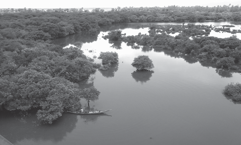
• Ecotone Zones: Wetlands serve as transition zones between terrestrial and aquatic ecosystems, like mangroves and floodplains.
• Adaptation to Flooding: Wetlands support plants and animals adapted to periodic flooding or waterlogging.
Indian Wetlands
• India has over 27,000 wetlands, occupying 18.4% of the country’s area.
• The majority are inland wetlands, with about 4,000 coastal wetlands.
• Natural wetlands in India range from high-altitude regions in the Himalayas to coastal areas like lagoons, backwaters, estuaries, mangroves, swamps, and coral reefs.
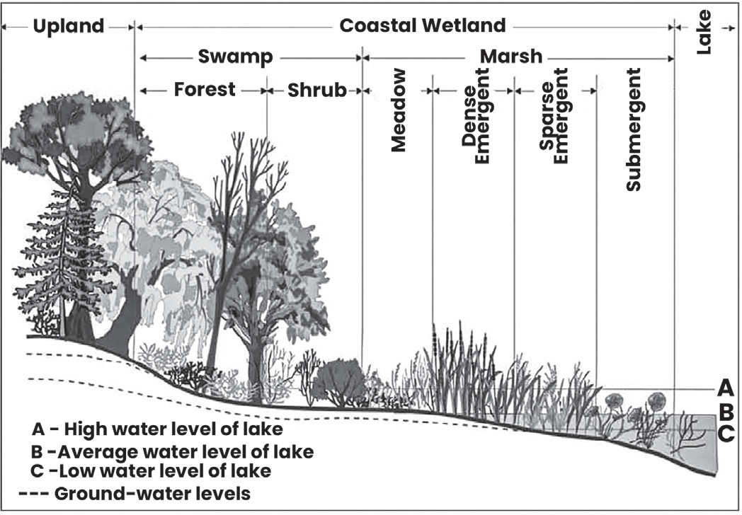
Differences between Wetlands and Lakes
• Wetlands are generally considered more important than lakes for ecosystem and biodiversity conservation.
• There’s no clear distinction between lakes and wetlands. Wetlands are shallow, while lakes can be either deep or shallow.
• The National Lake Conservation Programme (NLCP) defines lakes as standing water bodies with a minimum depth of 3 meters, usually covering more than ten hectares, and having little to no aquatic vegetation.
• Wetlands are typically less than 3 meters deep and are nutrient-rich, often supporting abundant aquatic plants (macrophytes).
•
Wetlands support high densities of diverse fauna, including birds, fish, and macroinvertebrates, making them valuable for biodiversity conservation.
• While excessive growth of macrophytes in wetlands can negatively impact water quality and usage, marginal aquatic vegetation is beneficial. It helps prevent erosion, provides habitat for wildlife, and improves water quality.
Importance of Wetlands
• Ecosystem Services:
• Wetlands provide numerous benefits, known as “ecosystem services,” which include freshwater supply, food, building materials, biodiversity conservation, flood control, groundwater recharge, and climate change mitigation.
• Habitat:
• They are habitats for aquatic plants and animals, and numerous species of native and migratory birds.
• Tourism:
• Wetlands are valuable for sustainable tourism, attracting visitors for bird watching, fishing, and enjoying natural beauty.
• Water Purification:
• They purify water by filtering sediments and nutrients from surface water, enhancing water quality.
• Nutrient Recycling and Groundwater Recharge:
• Wetlands recycle nutrients, recharge groundwater, and help stabilize the local climate.
• Flood Mitigation:
• They play a critical role in flood control by regulating the rate of runoff, reducing the impact of floods.
• Erosion Buffer:
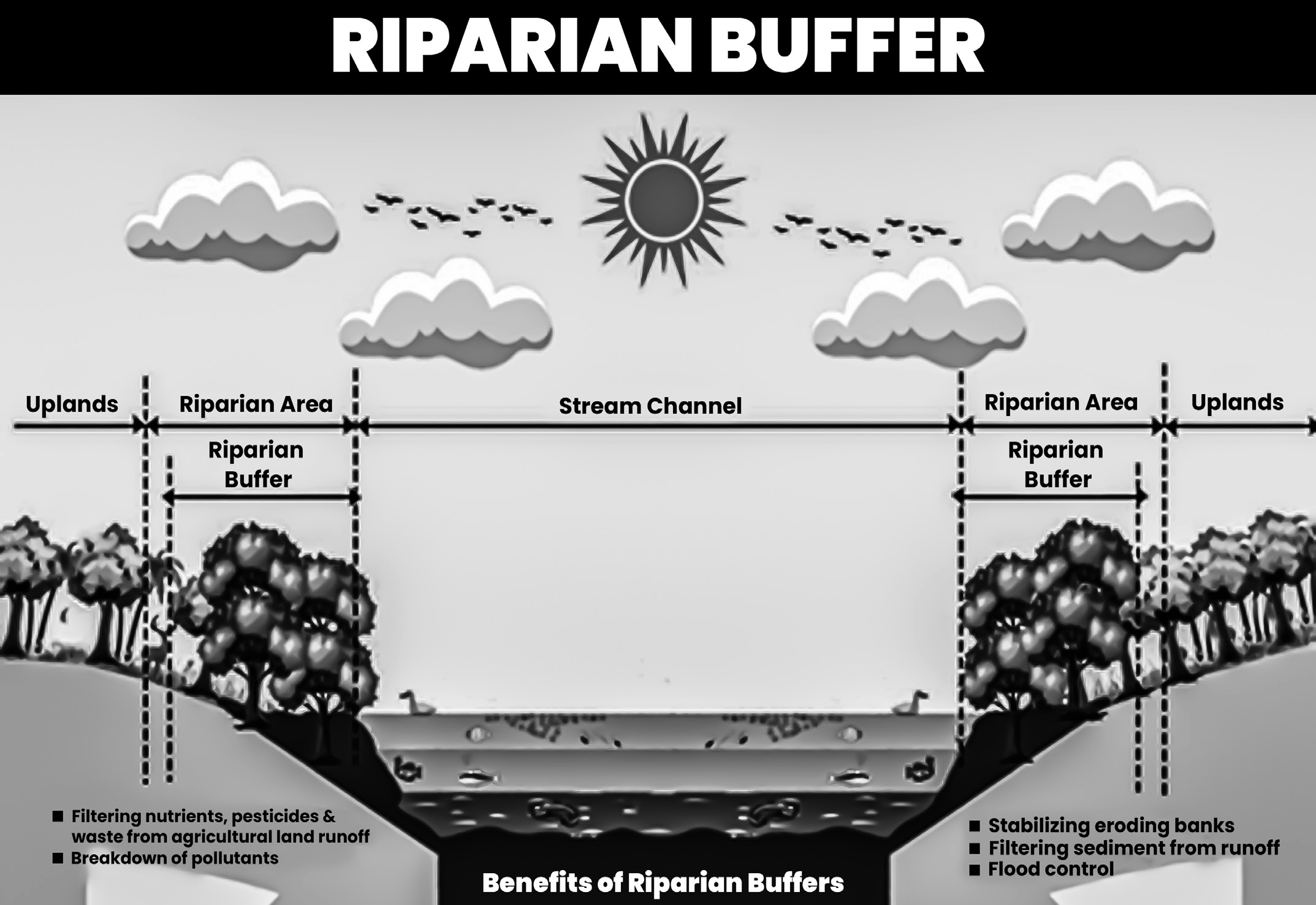
• Wetlands act as buffers against shoreline erosion and pollutants, protecting coastal and riparian areas.
• Genetic Reservoir:
• They serve as genetic reservoirs for various plant species, including important crops like rice.
Reasons for the Depletion of Wetlands
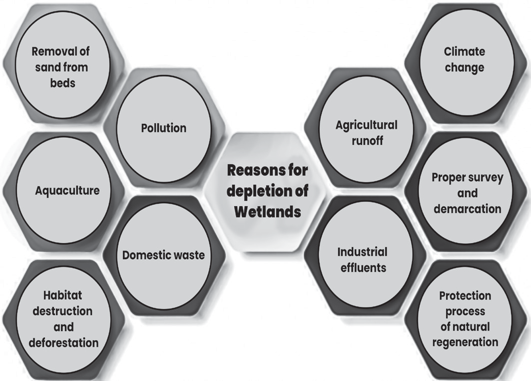
• Pollution:
• Wetlands are being depleted due to the dumping of excessive pollutants, such as industrial effluents, domestic waste, and agricultural runoff, which exceed their natural recycling capacity.
• Habitat Destruction and Deforestation:
• Destroying habitats and deforestation disrupt the ecological balance by affecting the populations of species that depend on wetlands.
• Agricultural Conversion and Encroachment:
• Wetlands are being converted for agricultural use and encroached upon by individuals and groups, reducing their size and health.
• Overfishing and Aquaculture:
• Intensive fishing and fish farming (aquaculture) can degrade wetland ecosystems, affecting biodiversity and water quality.
• Overgrazing:
• Grazing by livestock in marshy areas can damage the soil and vegetation, leading to erosion and habitat degradation.
• Sand Removal:
• Extracting sand from beds near seas makes wetlands more vulnerable to erosion by wave action and tidal movements.
Measures to Protect Wetlands
Mitigation of Wetland Destruction
• Demarcation and Enforcement:
• Utilising advanced technology for accurately demarcating wetlands and strict enforcement of laws with severe penalties for violators can help protect these ecosystems.
• Control of Aquaculture and Shellfish Cultivation:
• Implementing measures to prevent unsustainable practices in aquaculture and shellfish cultivation can reduce the negative impact on wetlands.
• Effluent Treatment:
• Treating industrial effluents and agricultural runoff before releasing them into wetlands helps maintain water quality and ecosystem health.
• Sustainable Utilisation:
• Promoting sustainable use of wetlands by allowing for natural regeneration and implementing artificial regeneration techniques when necessary.
• Afforestation and Weed Control:
• Afforestation efforts and weed control initiatives can help restore and maintain the ecological balance of wetland areas.
•
Prevention of Invasive Species:
• Implementing preventive measures to stop the introduction and spread of invasive species, such as water hyacinth, is crucial for wetland conservation.
• Soil Conservation and Grazing Control:
• Implementing soil conservation measures and controlling grazing activities in wetland peripheries can prevent soil erosion and habitat degradation.
• Wildlife Conservation and Eco-tourism:
• Promoting wildlife conservation and eco-tourism initiatives can raise awareness among local communities and visitors about the importance of wetland ecosystems.
• Eutrophication Abatement:
• Implementing measures to reduce nutrient-rich discharge into water bodies can help mitigate eutrophication, which is harmful to wetland ecosystems.
• Community Engagement:
• Involving local communities in wetland conservation efforts fosters a sense of ownership and responsibility towards these vital ecosystems.
Ramsar Convention on Wetlands
• Objective and Scope:
• The Ramsar Convention, also known as the Convention on Wetlands, aims to protect and conservewetland ecosystems and the biodiversity they support, particularly waterfowl.
• Origin and Name:
• Named after the city of Ramsar in Iran, where the convention was signed on February 2, 1971, and came into force in 1975.
• Protection of Wetlands:
• The primary goal of the convention is to address the significant loss of wetlands worldwide, with approximately 60% disappearing in the last century.
• Contracting Parties:
• Member countries that join the convention are referred to as Contracting Parties and are obligated to uphold general and specific duties related to wetland conservation.
• Designation of Wetlands of International Importance:
• The convention establishes a mechanism for identifying and designating wetlands of international significance, known as “List of Wetlands of
International Importance,” which receive special attention and protection.
• Scope of Coverage:
• The convention encompasses various types of wetland habitats, including rivers, lakes, ponds, marshes, coastal areas, estuaries, bogs, and even coral reefs, reflecting the diverse nature of wetland ecosystems.
Core Pillars of Ramsar Convention
• Wise Use of Wetlands:
• This pillar emphasizes maintaining the ecological character of wetlands by implementing ecosystem approaches. This approach involves integrated management of land, water, and living resources to promote conservation and sustainable use in a balanced and equitable manner.
• List of Wetlands of International Importance:
• The Ramsar Convention establishes a mechanism for designating and managing wetlands of international significance. Wetlands included in this list receive special attention and protection to ensure their conservation and sustainable use.
•
International Cooperation:
• This pillar focuses on fostering collaboration among countries, especially for wetlands that span across national boundaries (transboundary wetlands). By working together, countries can address shared challenges and ensure the effective management and conservation of these important ecosystems.
What is a Wetland defined by Ramsar Convention?
• The Ramsar Convention defines wetlands as areas characterized by marshes, fens, peatlands, or water, whether they occur naturally or are human-made, and whether they are permanent or temporary.
• These areas can have static or flowing water, and they can be freshwater, brackish, or saltwater. Wetlands encompass a wide range of environments, including marine areas where the water depth at low tide does not exceed six meters.
• Also, Ramsar Sites, which are designated wetlands of international importance, may include riparian and coastal zones adjacent to the wetlands, as well as islands or bodies of marine water deeper than six meters at low tide that are located within the wetland boundaries.
• This comprehensive definition ensures that various types of wetlands and their associated ecosystems are recognised and protected under the Ramsar Convention.
Criteria for Ramsar Sites
As per the convention, there are 9 criteria for identification
Contracting Parties (COP) to Ramsar Convention on Wetlands
• COP is the policy-making organ of the Convention which adopts decisions (resolutions and recommendations) to administer the work of the Convention.
• Every three years, representatives of the COP meet as the Conference of the Contracting Parties (COP)
What are the Responsibilities of the Contracting Parties
• A key commitment of the Contracting Parties is to identify and place suitable wetlands onto the List of Wetlands of International Importance, also known as the Ramsar List.
• Contracting Parties are expected (not mandated) to manage their Ramsar Sites so as to maintain their ecological character and retain their essential functions and values for future generations.
• The Convention specifies that “Contracting Parties shall formulate and implement their planning so as to promote the conservation of the wetlands included in the List”.
• Article 2(4) requires that each Contracting Party, when acceding to the Convention, shall designate at least one wetland for inclusion in the List of Wetlands of International Importance.
• In cases of “urgent national interests”, it is possible to
delete wetlands from the list or restrict their boundaries. No site has yet been deleted from the List.However, such deletions or restrictions should be compensated for by
for wetlands. A wetland can be considered internationally important if any of the following 9 criteria apply.
the creation of additional nature reserves either in the same area or elsewhere.
International Organization Partners of Ramsar Convention
The Ramsar Convention works closely with six organisations known as International Organization Partners (IOPs). These are:
• Birdlife International
• International Union for Conservation of Nature (IUCN)
• International Water Management Institute (IWMI)
• Wetlands International
• World Wide Fund for Nature (WWF)
• International Wildfowl & Wetlands Trust (WWT)
• Other Partners
• Convention on Biological Diversity (CBD)
• Convention to Combat Desertification (UNCCD),
• Convention on the Conservation of Migratory Species of Wild Animals
• Convention on Migratory Species (CMS),
• World Heritage Convention (WHC) and
• Convention on International Trade in Endangered Species (CITES).
• Project funding is done by various groups like multilateral development banks, bilateral donors, UN agencies such as UNEP, UNDP, Non-governmental organisations etc.
Some Important Facts
• There are over 2,400 Ramsar Sites covering 2.5 million
sqkm on the territories of 172 Ramsar Contracting Parties
across the world.
• First country to join Ramsar Convention: Denmark
• 1st Ramsar Site in the world- Cobourg Peninsula in Australia (1974).
• Country with most Ramsar Site - United Kingdom (175).
• Site with largest area: Bolivia
• The Global Wetland Outlook (GWO) is published by The Secretariat of the Ramsar Convention (1971)
• According to GWO-2025, the wetlands are degrading three times faster than forests.
• Total of 400 million hectares of wetland present in earth has been lost since 1970
The Montreux Record
• The Montreux Record established in 1990 is a register of wetland sites on the List of Wetlands of International Importance where changes in ecological character have occurred, are occurring, or are likely to occur as a result of technological developments, pollution or other human interference.
• It is maintained as part of the Ramsar List.
• Sites may be added to and removed from the Record only with the approval of the Contracting Parties in which they lie.
Montreux record sites in India
Chilika Lake (Orissa) – 1st Indian site to be inscribed on the Montreux Record in 1993 and was taken off record in 2002.
Loktak Lake (Manipur): Due to deforestation, invasiveness of water hyacinth construction of a hydroelectric power plant.
Keoladeo National Park: Excessive grazing, invasive growth of the grass and reduction in the population of migratory species.
Ramsar Advisory Mission
• It is a technical assistance mechanism formally adopted in 1990.
• The main objective of this mechanism is to provide assistance to developed and developing countries alike in solving the problems or threats that make inclusion in the Montreux Record necessary.
• In most cases, the application of this mechanism consists of a visit by a team of two or more experts who will produce a report on their findings and recommendations. Between 1988 and 2007, the Ramsar Advisory Mission mechanism has been applied at 58 Ramsar sites or groups of sites.
Wetlands International

• It is an independent, global, not-for-profit organisation established in 1995, that
works to sustain and restore wetlands and their resources for people and biodiversity supported by government and NGO membership from around the world.
• History:
• It was founded in 1937 as the International Wildfowl Inquiry
• Later, the name became International Waterfowl & Wetlands Research Bureau (IWRB) – Included Wetlands protection also.x
• Later, organizations with similar objectives emerged in Asia and the Americas: The Asian Wetland Bureau (AWB) (initiated as INTERWADER in 1983) and Wetlands for the Americas (WA) (initiated in 1989).
• In 1991, the three organisations started to work closely together.
• In 1995, the working relation developed into the global organisation Wetlands International.
Ramsar Sites & India
• India is one of the Contracting Parties to Ramsar Convention, signed in Ramsar, Iran, in 1971. India signed it on 1st Feb 1982.
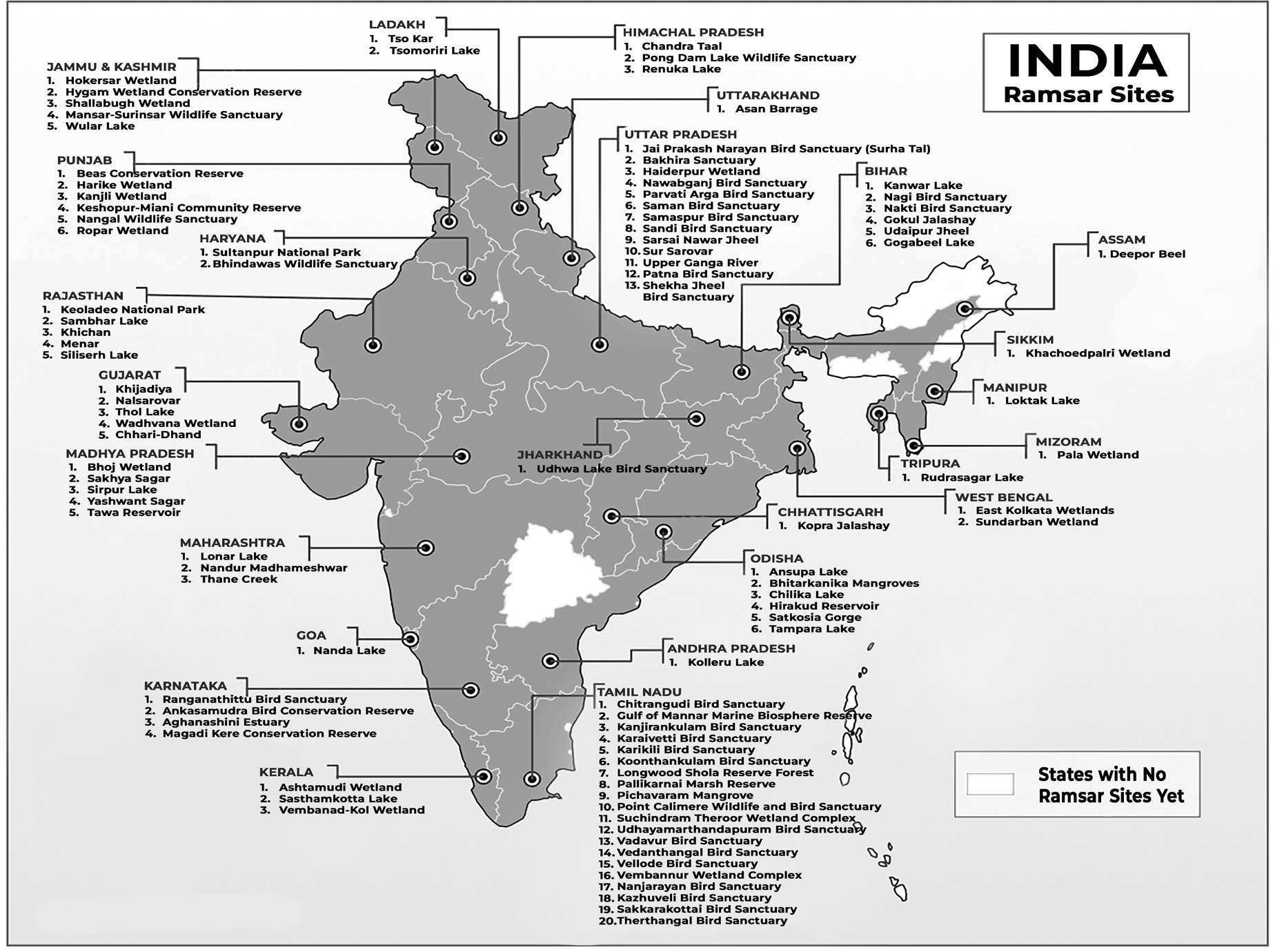
• As on June 2026, India has total 100 Ramsar sites in which Tamil Nadu (20) has the highest, followed by UP (Figures can change)
Some of the Important Ramsar Sites in India
• Ansupa Lake (Odisha)
• Designated in 2021
• It is a small freshwater oxbow lake formed by the Mahanadi river and is known for its scenic beauty and rich biodiversity.
• It also sustains the water demands of the surrounding areas and supports the fishing and farming livelihoods of the local communities.
• Asan Conservation Reserve (Uttarakhand)
• Designated in 2020
• The Asan Conservation Reserve is a stretch of the Asan River running down to its confluence with the Yamuna River in Dehradun district of Uttarakhand.
• It supports Red-headed vulture, white-rumped vulture and Baer’s pochard.
• Ashtamudi Lake (Kerala)
• Designated in 2021
• Ashtamudi wetland is 2nd largest estuarine system at Neendakara known for its biodiversity and fish diversity (famous fishing harbour).
• The site also supports number of mangrove species.
•
Natural backwater in Kollam District.
• River Kallada and Pallichal drains into it.
• National Waterway Passes through it.
• Bakhira Wildlife Sanctuary (UP)
• Designated in 2021
• It is a freshwater marsh and largest natural floodplain wetland of eastern UP.
• This wetland is important for its birdlife as it supports over 80species and provide wintering ground for over 25 species which migrate on Central Asian Flyway.
• Beas Conservation Reserve (Punjab)
• Designated in 2019
• Located on a stretch of 185km on Beas River.
• The reserve also hosts the only known population of endangered Indus River Dolphin in India.
• In 2017, re-introduction of Gharial happened at the site.
• Bhindawas Wildlife Sanctuary (Haryana)
• Designated in 2021
• It is a human-made freshwater wetland and largest in Haryana.
• It is also protected as an Eco-sensitive zone by MoEFCC.
• The Sanctuary contributes to maintaining the region’s water table by recharging groundwater, and is also a natural flood buffer.
• Bhitarkarnika Mangroves (Odisha)
• Designated in 2002
• They are one of the finest remaining patches of mangrove forests along Indian coast.
• Bhitarkanika Wildlife Sanctuary includes Gahirimatha Marine Wildlife Sanctuary beach around these mangroves hosts the largest known site for nesting of Olive Ridley Sea turtle.
• The core area of the Bhitarkanika Mangrove was declared as National Park.
• Bhoj Wetland (Madhya Pradesh)
• Designated in 2002
• It consists of two contiguous human-made reservoirs (Bhojtal and Lower Lake). Lakes are rich in biodiversity, particularly for macrophytes, phytoplankton, both natural and cultured fish species.
• It is famous for Sarus Crane.
• Chandertal/Chandra Taal Wetland (Himachal Pradesh)
• Designated in 2005
• It is a high-altitude lake on upper Chandra valley flowing to the Chandra River near Kunzam pass.
• It supports Snow Leopard along with Blue Sheep, Himalayan Ibex, Red Fox.
• Chilika Lake (Odisha)
• Designated in 1981
• It is a brackish lake separated from Bay of Bengal by a long sandy ride and subject to sea water exchange.
• Site is important for breeding wintering and staging for 33 species of waterbirds.
• It is the largest coastal lagoon in India.
• Nalbana Bird Sanctuary is the core area of the Ramsar Site.
• Irrawaddy Dolphin is found here.
• Chitrangudi Bird Sanctuary (Tamil Nadu)
• Designated in 2021
• The wetland has been protected as an Important Bird and Biodiversity Area (IBA).
• It is famous breeding ground for wintering birds such as spot-billed pelican, painted stork, little egret and grey heron.
• Deepor Beel (Assam)
• Designated in 2002
• It is a permanent freshwater lake in a former channel of Brahmaputra river.
• It is also a site on migratory flyway, especially in winter.
• East Calcutta Wetlands (West Bengal)
• Designated in 2002
• It is a world-renowned model of a multiple use wetland which have saved the city of Calcutta from the costs of constructing and maintaining water treatment plants. The system is described as “one of the rare examples of environmental protection and development
management where a complex ecological process has been adopted by the local farmers for mastering the resource recovery activities.
• Gulf of Mannar Marine Biosphere Reserve (Tamil Nadu)
• Designated in 2022
• Located at the south-eastern trip, it is the first Marine Biosphere reserve in South and South-East Asia.
• It is famous for Dugong, whale shark, green sea turtle, hawksbill turtle and Indo-pacific humpback dolphin.
• Haiderpur Wetland (Uttar Pradesh)
• Designated in 2021
• It is a human-made wetland formed by construction of Madhya Ganga Barrage on a floodplain of Ganga.
• Located within boundaries of Hastinapur Wildlife Sanctuary.
• Harike Lake (Punjab)
• Designated in 1990
• It is a bird sanctuary and a shallow water reservoir with thirteen islands, at the confluence of two rivers Beas and Sutlej.
• The entire lake is leased on an annual basis to commercial fishery organizations.
• Hirakud Reservoir (Odisha)
• Designated in 2021
• One of the largest man-made reservoirs in India, built across Mahanadi river.
• The reservoir helps regulate the water level of the river and moderates the impact of floods in Mahanadi delta.
• Hokera Wetland Conservation Reserve (Jammu & Kashmir)
• Designated in 2005
• Located at the north-west Himalayan biogeographic province of Kashmir.
• It is a natural perennial wetland contiguous to the Jhelum basin.
• It is the only site with remaining reedbeds of Kashmir and pathway of 68 waterfowl species like Large Egret, Great Crested Grebe, Little Cormorant, Common Shelduck, Tufted Duck and endangered White-eyed Pochard.
• Hygam Wetland Conservation Reserve (Jammu & Kashmir)
• Designated 2022
• It lies downstream of Wular Lake and is an important site for biodiversity conservation. It lies on Central Asian Flyway and over 40,000 migratory and resident bird species have been recorded annually.
• It is also an Important Bird Area (IBA).
• Kabartal/Kanwar Taal Wetland (Bihar)
• Designated in 2020
• Also known as Kanwar Jheel, lies in Indo-Gangetic plains.
• It floods during monsoon and thus plays vital role in absorption of floodwaters.
• The Wetland is an important stopover along the Central Asian Flyway, with 58 migratory waterbirds using it to rest and refuel.
• Kanjirakulam Bird Sanctuary (Tamil Nadu)
• Designated in 2022
• It is a nationally protected area and a notable resting site for several migratory birds.
• Besides its rich biodiversity, the wetland supports the adjacent ecosystems and communities by providing irrigation, flood control, and erosion control.
• It is culturally important to the local communities, who are known to protect the birds from poaching and other threats.
• Kanjli Wetland (Punjab)
• Designated in 2002
• The site fulfils Criteria 3 because of its importance in supporting a considerable diversity of aquatic, mesophytic, and terrestrial flora and fauna in the biogeographical region, and acts also as a key regulator of groundwater discharge and recharge with the seasons.
• Karikili Bird Sanctuary (Tamil Nadu)
• Designated in 2022
• It comprises two rain-fed non-perennial irrigation tanks
spreading over an area of more than 58 hectares.
• The Site provides habitat for a variety of resident and migratory birds, most of them waterbirds, as well as a few species of scavengers.
• It is famous for Oriental darter (Anhinga melanogaster) and spot-billed pelican breed here.
• Keoladeo National Park (Rajasthan)
• Designated in 1981
• A complex of ten artificial, seasonal lagoons, varying in size, situated in a densely populated region.
• It is also a World Heritage site and a Bird Sanctuary.
• Keshopur-Miani Community Reserve (Punjab)
• Designated in 2019
• It is a mosaic of natural marshes, aquaculture ponds and agricultural wetlands maintained by the annual rainfall runoff.
• It is heavily human-influenced, and includes a series of managed fishponds and cultivated crops such lotus and chestnut.
• Khijadia Wildlife Sanctuary (Gujarat)
• Designated in 2021
• It is a freshwater wetland near Gulf of Kutch.
•
It is an important waterbird habitat in North-west India.
• The site provides breeding, feeding and roosting grounds for a wide range of resident aquatic and also land-based birds.
• Kolleru Lake (Andhra Pradesh)
• Designated in 2002
• It is a natural eutrophic lake, situated between the two major river basins of Godavari and the Krishna.
• It functions as a natural flood balancing reservoir between deltas of the two rivers.
• It also provides habitat for a number of resident and migratory birds.
• Koonthankulam Bird Sanctuary (Tamil Nadu)
• Designated in 2021
• The wetland is the largest reserve for breeding resident and migratory waterbirds in South India.
• It is an Important Bird and Biodiversity Area (IBA) on Central Asian Flyway.
• The wetland supports rich social and cultural heritage as well as the agriculture which is the major source of local people’s livelihoods.
• Loktak Lake (Manipur)
• Designated in 1990
• It is a large but shrinking freshwater lake and associated swampland supplied by several streams.
• Keibul Lamjao National Park is located here.
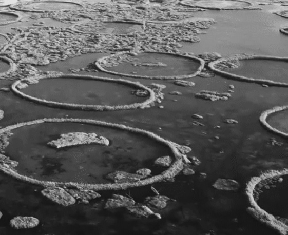
• The national park is characterized by floating decomposed plant material locally called phumdi – Floating Vegetation
• Eld’s deer/Thamin/Brow-antlered deer/Sangai/ Dancing Deer is found here.
• Lonar Lake (Maharashtra)
• Designated in 2020
• This wetland on the Deccan Plateau is an endorheic or closed basin, almost circular in shape, formed by a meteorite impact onto the basalt bedrock.
• The lake is high in salinity and alkalinity, as the lack of an outflow leads to a concentration of minerals as the lake water evaporates.
• Specialized micro-organisms such as anaerobes, cyanobacteria and phytoplankton survive in this harsh chemical environment.
• Sometimes the Lonar Lake turns Pink in colour due to the presence of salt loving Haloarchaea Bacteria.
• Nalsarovar (Gujarat)
• Designated in 2012
• It is also a bird sanctuary as well as a wildlife sanctuary. A natural freshwater lake represents a dynamic environment with salinity and depth varying depending on rainfall. It is an important stopover site within the Central Asia Flyway, with globally threatened species such as the critically endangered Sociable Lapwing and the vulnerable Marbled Teal.
• Nanda Lake (Goa)
• Designated in 2022
• It is an intermittent freshwater marsh that lie adjacent to one of the major tributaries of the Zuari River. This wetland supports a wide variety of migratory waterbirds and many other important plants and animals. The Site enables local communities to store water during the off- monsoon season, to cultivate rice paddies downstream of the lake and support fishing and recreation.
• Nandur Madhameshwar (Maharashtra)
• Designated in 2019
• Construction of the Nandur Madhameshwar Weir at the confluence of the Godavari and Kadwa Rivers helped create a thriving wetland: originally designed to overcome water shortages in the surrounding area, the Site now also serves as a buffer against floodwaters and as a biodiversity hotspot. It also provides sanctuary to critically endangered species including Deolali minnow, Indian vulture and white-rumped vulture.
• Nangal Wildlife Sanctuary (Punjab)
• Designated in 2019
• Located in the Shiwalik foothills of Punjab is the highly eco-sensitive Nangal Wildlife Sanctuary, which supports abundant flora and fauna including threatened species, such as the endangered Indian pangolin and Egyptian vulture and the vulnerable leopard. The site is of historic importance as the Indian and Chinese Prime Ministers formalized the “Five Principles of Peaceful Coexistence” there in 1954.
• Nawabganj Bird Sanctuary (Uttar Pradesh)
• Designated in 2019
• It is a shallow marshland fed by monsoon rains while the Sarda Canal supplies additional water. This wetland supports recreation and tourism activities as well as local biodiversity. It is a haven for birds, with 25,000 waterbirds regularly recorded and 220 resident and migratory species documented.
• It is renamed Chandra Shekhar Azad Bird Sanctuary in 2015.
• Pala Wetland (Mizoram)
• Designated in 2021
•
It is the largest natural wetland in the state of Mizoram. The wetland supports a rich diversity of animal species, including at least seven mammals, 222 birds, 11 amphibians and 21 reptiles. Pala Wetland is revered by the local Mara people and has a deep connection with their history.
• Pallikaranai Marsh Reserve Forest (Tamil Nadu)
• Designated in 2022
• This freshwater marsh and partly saline wetland situated about 20 kilometres south of the city of Chennai serves as an aquatic buffer of the flood-prone Chennai. The Site is threatened by invasive and non-native species, household sewage, urban wastewater and droughts. In response, the Conservation Authority of Pallikaranai Marsh is currently implementing a site-specific management plan.
• Parvati Agra Bird Sanctuary (Uttar Pradesh)
• Designated in 2019
• It is a permanent freshwater environment consisting of two oxbow lakes. The Sanctuary is a refuge for some of India’s threatened vulture species: the critically endangered white-rumped vulture and Indian vulture, and the endangered Egyptian vulture have all been recorded.
• Pichavaram mangrove (Tamil Nadu)
• Designated in 2022
• It is one of the largest mangrove ecosystems in India, located between the prominent estuaries of the Vellar and Coleroon Rivers. It not only offers waterscape and backwater cruises but also another rare sight – the mangrove trees are permanently rooted in a few feet of water.
• Point Calimere Wildlife and Bird Sanctuary (Tamil Nadu)
• Designated in 2002
• A coastal area consisting of shallow waters, shores, and long sand bars, intertidal flats and intertidal forests, chiefly mangrove, and seasonal, often-saline lagoons, as well as human-made salt exploitation sites. The site serves as the breeding ground or nursery for many commercially important species of fish, as well as for prawns and crabs.
• Pong Dam (Himachal Pradesh)
• Designated in 2002
• A water storage reservoir created in 1975 on the Beas River in the low foothills of the Himalaya on the northern edge of the Indo-Gangetic plain. The avian habitats formed by the creation of the Pong Dam assume a great significance”
- given the site’s location on the trans-Himalayan flyway.
• It is also known as Maharana Pratap Sagar Wetland.
• Ranganathittu Bird Sanctuary (Karnataka)
• Designated in 2022
• It is a part of the Kaveri River on the Southern Deccan Plateau. This region comprises gently rolling plains traversed by several of the large rivers that rise in the
Western Ghats and flow eastward to the Bay of Bengal. The Site is an ecologically important riverine wetland, rich in plant and animal species.
• Renuka Wetland (Himachal Pradesh)
• Designated in 2005
• A natural wetland with freshwater springs and inland subterranean karst formations, fed by a small stream flowing from the lower Himalayan out to the Giri river. The lake has high religious significance and is named after the mother of Hindu sage Parshuram, and is thus visited by thousands of pilgrims and tourists.
• Ropar (Punjab)
• Designated in 2002
• A human-made wetland of lake and river formed by construction of a barrage for diversification of water from the Sutlej river for drinking and irrigation supplies. Deforested local hills leading to siltation, and increasing industrialization causing an inflow of pollutants, are potential threats, and invasive weeds are a further cause for concern.
• Rudrasagar Lake (Tripura)
• Designated in 2005
• A lowland sedimentation reservoir in the northeast hills, fed by three perennial streams discharging to the River Gomti. The lake is abundantin commercially important freshwater fishes and an ideal habitat for IUCN Red listed Three-striped Roof Turtle.
• Sakhya Sagar (Madhya Pradesh)
• Designated in 2022
• It is a human-made reservoir on the outskirts of Shivpuri town within the Madhav National Park. The Site features a mosaic of landforms including open water and surrounding marshes, plantations and a small patch of agricultural land. The wetland also plays a vital role in nutrient cycling, groundwater recharge, and regulating the micro-climate of the area.
• Saman Bird Sanctuary (Uttar Pradesh)
• Designated in 2019
• The Saman Bird Sanctuary in the Mainpuri district is a seasonal oxbow lake on the Ganges floodplain. It is heavily reliant on the arrival of the south-westerly monsoon which provides the vast majority of annual rainfall. Ecosystem services provided include supply of fresh water for agriculture, as well as recreation and nature-based tourism based around the huge diversity of birds.
• Samaspur Bird Sanctuary (Uttar Pradesh)
• Designated in 2019
• It is a perennial lowland marsh typical of the Indo- Gangetic Plains. Its six connected lakes are heavily relevant on monsoon rains. Annual counts regularly find
more than 75,000 birds present, with over 250 resident and migrant species documented. The Sanctuary harbours threatened species such as the endangered Egyptian vulture and Pallas’s fish eagle.
• Sambhar Lake (Rajasthan)
• Designated in 1990
• It is a largest inland saline lake fed by four streams set in a shallow wetland and subject to seasonal fluctuations. It is surrounded by sand flats and dry thorn scrub and fed by seasonal rivers and streams.
• It is famous for flamingos.
• Sandi Bird Sanctuary (Uttar Pradesh)
• Designated in 2019
• It is a freshwater marsh in the Hardoi district of Uttar Pradesh. The wetland is typical of the Indo-Gangetic plains and receives most of its water from monsoon rains. Rich in aquatic plants, the Site provides a productive habitat for waterfowl with over 40,000 individuals.
• Sarsai Nawar Jheel (Uttar Pradesh)
• Designated in 2019
• It is a permanent marsh in the Etawah district of Uttar Pradesh. This typical wetland of the Indo-Gangetic floodplain is fed by precipitation run-off from the South West monsoon rains. It is an example of co-habitation of humans and wildlife i.e. farming practices across most of the Site play important roles in sustaining the waterbird habitats.
• Sasthamkotta Lake (Kerala)
• Designated in 2002
• It is the largest freshwater lake in Kerala (Bacteria – Cavaborous keeps the water fresh and clean) in the southwest of the country which is spring-fed and the source of drinking water for half a million people in the Kollam district.
• The ancient Sastha temple is an important pilgrimage centre.
• The water contains no common salt, mineral – therefore it doesn’t support water plants.
• Satkosia Gorge (Odisha)
• Designated in 2021
• It is a mosaic of rivers, marshes and evergreen forests at the meeting point of two biogeographic regions, the Deccan Peninsula and the Eastern Ghats. These wetland habitats support a variety of plant and animal communities. The wetland is also known for providing a variety of
ecosystem services to surrounding communities like fishing, recharging of groundwater, climate regulation, and safety from floods.
• Shallbugh Wetland Conservation Reserve (Jammu & Kashmir)
• Designated in 2022
• It is a shallow wetland which is primarily fed by rainfall, snowmelt from the Kashmir Himalayas and stream water from the river Sindh. It lies close to another Ramsar Site, Hokera Wetland and together they form an important aquatic habitat in this region.
• Sirpur Wetland (Madhya Pradesh)
• Designated in 2022
• It is a human-made wetland that has stabilized and acquired near-natural characteristics in the last two centuries. Commonly named Pakshi Vihar (bird sanctuary), the Site is a shallow,alkaline, nutrient-rich lake that floods during the monsoon to a maximum depth of two metres.
• Suchindram Theroor Wetland Complex (Tamil Nadu)
• Designated in 2022
• It lies at the southern tip of the Central Asian Flyway. The wetland comprises two man-made reservoirs, Theroor and Suchindram, that provide irrigation and habitat for wetland birds. It is an Important Bird and Biodiversity Area (IBA); around 250 species of birds have been recorded, of which 53 are migratory, 12 endemic, and four threatened.
• Sultanpur National Park (Haryana)
• Designated in 2021
• This shallow lake at the core of the Sultanpur National Park is fed by the overflow from neighbouring canals and fields, and replenished by saline groundwater. The lake features seasonal aquatic vegetation and is dotted with artificial islands; the Park also includes open grasslands.
• Sundarban Wetland (West Bengal)
• Designated in 2019
• It is located within the largest mangrove forest in the world, the Sundarbans, that encompasses hundreds of islands and a maze of rivers, rivulets and creeks, in the delta of the Rivers Ganges and Brahmaputra on the Bay of Bengal in India and Bangladesh. The mangrove forests protect the hinterland from storms, cyclones, tidal surges, and the seepage and intrusion of saltwater inland and into waterways.
• Surinsar-Mansar Lakes (Jammu & Kashmir)
• Designated in 2005
• It is a freshwater composite lake, adjoining the Jhelum basin with catchment of sandy conglomerate soil, boulders and pebbles. This composite lake is high in micro nutrients for which it is an attractive habitat, breeding and nursery ground for migratory waterfowls. The site is socially and culturally very important with many temples around owing to its mythical origin from the Mahabharata period.
• Sur Sarovar (Uttar Pradesh)
• Designated in 2020
• Also known as Keetham Lake, is a human-made
reservoir; originally created to supply water to the city of Agra in summer, the wetland soon became an important and rich ecosystem. The Site’s patchwork of different habitat types provides refuge to resident and migratory birds, and more than 60 species of fish.
• Tampara Lake (Odisha)
• Designated in 2021
• The lake is connected to the Rushikulya river and helps in flood control during the monsoon season. The lake receives flood waters coming from the river, making its biodiversity highly vulnerable to extreme heat and dry weather. Along with fish, the wetland also provides water for agriculture and domestic use and is used for recreation. It also provides a water pathway for local transportation of goods.
• Thane Creek (Maharashtra)
• Designated in 2022
• The Site is one of the largest creeks of Asia and hosts many birds migrating on the Central Asian Flyway. It is also an IBA and falls under the Marine Ecoregions of the World (MEOW). Its mangrove forests provide nurseries for several fish species, sustaining the local fisheries, and also act as a natural buffer against floods, cyclones and seawater intrusions.
• Thol Lake Wildlife Sanctuary (Gujarat)
• Designated in 2021
• This shallow reservoir dominated by open water areas was originally constructed for irrigation in 1912. it is on the Central Asian Flyway and more than 320 bird species can be found, making up some 57% of all the bird species of Gujarat. The Lake provides water for drinking and irrigation and enables groundwater recharge, and is also used for recreation and tourism.
• Tso Kar Wetland Complex (UT of Ladakh)
• Designated in 2020
• This high-altitude wetland complex is found at more than 4,500 metres above sea level in the Changthang region of Ladakh. The complex includes two connected lakes, the freshwater Startsapuk Tso and the larger hypersaline Tso Kar; it presents a notable example of two such lakes existing in close proximity.
• Tsomoriri (UT of Ladakh)
• Designated in 2002
• A freshwater to brackish lake lying at 4,595m above sea level, with wet meadows and borax-laden wetlands along the shores. The site is said to represent the only breeding ground outside of China for one of the most endangered cranes, the Black-necked crane, and the only breeding ground for Bar-headed geese in India.
• Udhayamarthandapuram Bird Sanctuary (Tamil Nadu)
• Designated in 2022
• The Sanctuary consists of human-made irrigation tanks,
interconnected by an ancient network of canals and fed by the Mettur dam through the Koraiyar canal. The Site is an important staging and breeding ground for several species of waterbirds. It also helps replenish groundwater and feeds surrounding smaller wetlands and agricultural land.
• Upper Ganga River (Uttar Pradesh)
• Designated in 2005
• It is a shallow river stretch of the great Ganges with intermittent small stretches of deep-water pools and reservoirs upstream from barrages. The river provides habitat for IUCN Red listed Ganges River Dolphin, Gharial, Crocodile, 6 species of turtles, otters, 82 species of fish and more than hundred species of birds.
• Vaduvur Bird Sanctuary (Tamil Nadu)
• Designated in 2022
• This wetland is composed of small man-made reservoirs interconnected by an ancient network of canals and fed by the Mettur reservoir, in the semi-arid district of Thiruvarur. The rooted floating aquatic plants distributed through the reservoir provide habitat for around 118 bird species. The interconnected wetland system acts as a buffer against flooding and also provides water during periods of drought.
• Vedanthangal Bird Sanctuary (Tamil Nadu)
• Designated in 2022
• It is a small irrigation tank in Vedanthangal village surrounded by rocky plains and low-ridged, denuded hillocks, this Site is an Important Bird and Biodiversity Area (IBA) due to the presence of several species including the black-headed ibis, Eurasian spoonbill, black-crowned night heron and painted stork.
• Vellode Bird Sanctuary (Tamil Nadu)
• Designated in 2022
• This human-made tank is an ideal habitat for birds, due to the abundant food resources it provides from neighbouring agricultural fields, and other aquatic organisms. It is an important staging and breeding ground for migratory birds on the Central Asian Flyway and also resident species. Although classified as a Bird Sanctuary by the national authorities, the Site is threatened by household sewage, urban waste water, vegetation clearance, land conversion and invasive non- native species.
• Vembanad-Kol Wetland (Kerala)
• Designated in 2002
• It is the largest brackish, humid tropical wetland ecosystem on the southwest coast of India, fed by 10 rivers and typical of large estuarine systems on the western coast, renowned for its clams and supporting the third largest waterfowl population in India during the winter months.
•
It is second largest Ramsar site.
• It is an important paddy cultivation site.
• Vembannur Wetland Complex (Tamil Nadu)
• Designated in 2022
• It is a human-made irrigation tank, situated a few kilometres inland in Kerala near the southernmost point of mainland India. The Site forms part of an Important Bird and Biodiversity Area (IBA) and it provides suitable habitat to several species of waterbird in the breeding and non-breeding seasons. The wetland supports more than 2,000 hectares of agricultural land on which more than 1,000 families depend.
• Wadhvana Wetland (Gujarat)
• Designated in 2021
• This wetland is located in a semi-arid agricultural landscape and it is surrounded by wheat and paddy fields and villages. The wetland is internationally important for its birdlife as it provides wintering ground to migratory waterbirds, including over 80 species that migrate on the Central Asian Flyway.
• Wular Lake (Jammu & Kashmir)
• Designated in 1990
• Wular lake is the largest freshwater lake in India with extensive marshes of emergent and floating vegetation, particularly water chestnut, that provide an important source of revenue for the State Government and fodder for domestic livestock. The lake supports an important fishing industry and is a valuable source of water for irrigation and domestic use.
• Yashwant Sagar (Madhya Pradesh)
• Designated in 2022
• It is a freshwater reservoir which supplies water to the Indore region. In more recent years, it has been also used for commercial aquaculture. This wetland is designated as an Important Bird and Biodiversity Area (IBA) and is one of the most important birdwatching sites in the region. When the water recedes in the winter, the wetland provides nesting, breeding, and foraging habitats for a large number of migratory birds including the vulnerable sarus crane.
• Ankasamudra Bird Conservation Reserve (Karnataka)
• It is a man-made Village Irrigation Tank built centuries back.
• It is an ecologically important wetland and rich in biodiversity.
• It is famous for Painted Stork and Black-headed Ibis.
• Aghanashini Estuary (Karnataka)
• It is formed at the confluence of the Aghanashini River with the Arabian Sea.
• It helps in traditional fish farming in the estuarine rice fields (locally known as Gazni rice fields), bivalve shell collection and salt production.
• Magadi Kere Conservation Reserve (Karnataka)
• It is a man-made wetland which was constructed to store rainwater for irrigation purposes.
• It is important for Common pochard and River tern, Oriental Darter Black-headed Ibis Woolly-necked Stork and Painted Stork
• It is also one of the largest wintering grounds for the Bar- headed goose.
• Karaivetti Bird Sanctuary (Tamil Nadu)
• It is a significant source of groundwater recharge for the area.
• The Longwood Shola Reserve Forest (Tamil Nadu)
• The name has its root from Tamil word, “Solai” meaning ‘tropical rainforest’.
• The ‘Sholas’ are found in the upper reaches of the Nilgiris, Anamalais, Palni hills, Kalakadu, Mundanthurai and Kanyakumari in Tamil Nadu.
• Some important species found here are Black-chinned Nilgiri Laughing thrush, Nilgiri Blue Robin and vulnerable Nilgiri Wood-pigeon.
• Nakti Bird Sanctuary
• Designated as a Bird Sanctuary in 1984 and in June 2024 as Ramsar site
• It is a man-made wetland constructed near at the Nakti Dam
• The catchment area is largely dry deciduous forest, and is surrounded by hills.
• Habitat for over 150 species of birds, mammals, fish, aquatic plants, and reptiles and amphibians
• Indian elephant (Elephas maximus indicus) status endangered and a vulnerable native catfish (Wallago attu).
• Nagi Bird Sanctuary
• Designated as an Important Bird and Biodiversity Area (IBA) by Bird Life International in 1984 and in June 2024 as Ramsar site
• The gradual formation of water bodies with clear water and aquatic vegetation on Nagi River
• Habitat for over 75 bird species, 33 fish, and 12 aquatic plants
• Hosts one of the largest congregations of bar-
headed goose (Anser indicus), threatened migratory species that winter at the Site include the critically endangered Baer’s pochard (Aythya baeri) and the endangered steppe eagle (Aquila nipalensis).
• Kazhuveli Bird Sanctuary
• Location: Tamil Nadu
• Situated along the eastern coastline of Tamil Nadu, adjacent to the Bay of Bengal, Kazhuveli Bird Sanctuary is one of the largest and most important wetlands on the Coromandel Coast, second only to Pulicat Lake. The wetland system is hydrologically connected to the sea through the Uppukalli Creek and the Yedayanthittu estuary, making it a critical site along the Central Asian Flyway for migratory birds.
• Kazhuveli supports a mosaic of habitats—from sloping wetlands favored by shorebirds, darters, and waders to floating vegetation zones and open grasslands that attract a diverse range of bird and animal species.
• It serves as a key feeding ground for long-distance migratory birds from subarctic regions of Central Asia and Siberia, including species such as the Black- tailed Godwit, Eurasian Curlew, White Stork, Ruff, and Dunlin.
• Nanjarayan Bird Sanctuary
• Location: Tiruppur District, Tamil Nadu
• Nanjarayan Bird Sanctuary is a shallow freshwater wetland located in northeastern Uthukuli Taluk. Spanning 125.865 hectares, the lake traces its origins back centuries, when it was restored by King Nanjarayan.
• Fed primarily by rainfall through the Nallar drainage system, the lake supports agriculture, groundwater recharge, and rich biodiversity.
• It is home to a variety of bird species, including the Bar- headed Goose, Northern Shoveler, Spot-billed Pelican, and several heronry species.
• Tawa Reservoir
• Location: Near Itarsi, Madhya Pradesh
• Situated at the confluence of the Tawa and Denwa rivers, the Tawa Reservoir was originally constructed for irrigation but now also supports hydropower generation and aquaculture.
• Nestled within the Satpura Tiger Reserve, it shares boundaries with both Satpura National Park and Bori Wildlife Sanctuary, enhancing its ecological significance.
• The reservoir is home to notable wildlife including Spotted Deer and Painted Storks, making it an important habitat for both aquatic and terrestrial biodiversity.
• Sakkarakottai Bird Sanctuary
• Location: Tamil Nadu
• Situated near the Gulf of Mannar, the Sakkarakottai Bird Sanctuary is a distinctive mosaic wetland ecosystem that lies along the Central Asian Flyway—a major route for migratory birds traveling from regions such as Iran, Afghanistan, and Pakistan. This sanctuary serves as a vital breeding ground for numerous resident and migratory waterfowl species, playing a key role in avian biodiversity conservation.
• Therthangal Bird Sanctuary
• Location: Tamil Nadu
• Located along the Central Asian Flyway, the Therthangal Bird Sanctuary is an essential breeding and feeding habitat for a variety of waterbirds, including the Spot- billed Pelican, Black-headed Ibis, and Oriental Darter. Beyond its ecological significance for avifauna, the sanctuary also supports crucial ecosystem services such as groundwater recharge, climate regulation, and agricultural irrigation. It is a haven for several endemic and near-threatened species like the Painted Stork, Pallied Harrier, and others.
• Udhwa Lake Bird Sanctuary
• Location: Jharkhand
• Named after the sage Uddhava from the Mahabharata era, the Udhwa Lake Bird Sanctuary is located in the Gangetic Plains biogeographic zone. It comprises two interconnected water bodies—Patauran (155 hectares), known for its clean waters, and Berhale (410 hectares). Recognized as Jharkhand’s first Ramsar site, this sanctuary supports a rich diversity of aquatic life and migratory bird species, contributing significantly to wetland conservation in eastern India.
• Khecheopalri Lake
• Location: Sikkim
• Nestled in the sacred Demazong valley, Khecheopalri Lake is a revered pilgrimage site for both Buddhists and Hindus. Also known as the "wish-fulfilling lake," it is believed to be blessed by Guru Padmasambhava and the Goddess Tara. Surrounded by dense forests and steeped in mythological lore, this tranquil lake embodies a harmonious blend of spirituality, ecological significance, and natural beauty.
• Gokul Jalashay:
• Location –Bihar
• Date of declaration- 26.09.2025
• Area – 448 hectares
•
It is situated on the southern edge of the Ganga River in Buxar District of Bihar. The Ganga River is flowing just north of this Ramsar site. It is an oxbow lake made by the erosion of the Ganga. This wetland is the house of the more than fifty bird species. This wetland is mostly marshy and swampy in nature due to proximity with the ganga and also get impacted by heavy rain in the monsoon season.
• Udaipur Jheel
• Location – Bihar
• Date of declaration- 26.09.2025
• Area – 319 hectares
• It is situated just near the famous Udaipur Wildlife Sanctuary in West Champaran of Bihar. The lake is a natural oxbow system formed by the erosion of the Gandaki river which is one of the tributaries of the Ganga. This wetland consists more than 35 migratory bird species. Various vulnerable and endangered species of the birds are found here. Alysicarpus roxburghianus which is endemic in India is naturally found here. Central Asian species like bar-headed geese and Ruddy Shelducks which migrates to India, can observe here in winter season.
• Gogabil Lake
• Location - Bihar
• Date of declaration- 30.10.2025
• Area – 86.63 hectares
• Gogabil Lake is located at the Katihar district of Bihar in between Mahananda River and the Ganga River. It is an ox-bow lake in a fertile land of Bihar and formed as a result of river erosion. As it gains water from the Gangas and its tributaries, it remains submerge with water throughout the year. This wetland consists favourable conditions for breeding of various vulnerable and least threat species like Helicopter catfish, River tern, Greylag Goose etc.
• Kopra Jalashay
• Location - Chattisgarh
• Date of declaration- 12.12.2025
• Area – 210 hectares
• Kopra Jalashay is an artificial wetland located at the bank of Mahanadi River in the Bilaspur district of Chhattisgarh. 60 migratory bird species are recorded here, that includes vulnerable and endangered species like Egyptian vulture, Indian pangolin etc.
• Chhari Dhand
• Location - Gujarat
• Date of declaration- 30.01.2026
• Area – 22700 hectares
• The word Chhari originated from the word Char which means saline or base.it is located near the Banni grassland 60km away from Bhuj. It was the first ‘Conservation Reserve’ of Gujarat. The species recorded here are Dalmatian Pelican, flamingos, Chinkara etc.
• Menar Wetland Complex
• Location - Rajasthan
• Date of declaration- 04.06.2025
• Area – 463.413 hectares
• It is made by two lakes one is Brahma Talab and another is Dhand Talab. This wetland consists Bar-headed goose, Black-necked Stork, demoiselle cranes, Eurasian coot etc.
• Khichan wetland
• Location - Rajasthan
• Date of declaration- 04.06.2025
• Area – 54.187 hectares
• It is one of the four wetlands of Rajasthan. It is located in the thar desert of Rajasthan. This wetland is the home of more than 150 species which are unique, vulnerable and endangered like Anthropoides virgo, Demoiselle cranes etc.
• Siliserh Lake
• Location - Rajasthan
• Date of declaration- 12.12.2025
• Area – 315.97 hectares
• It is an artificial wetland at a distance of 13 km away from from Alwar in Rajasthan. The lake is the home of more than 100 species of birds like kingfishers, black stork etc.
• Patna Bird Sanctuary
• Location - Uttar Pradesh
• Date of declaration- 30.01.2026
• Area – 108.86 hectares
• Patna Vihar Bird Sanctuary is a protected sanctuary, which was established in 1991 as a bird sanctuary and declared as wetland site in 2026. It is the smallest bird sanctuary of Uttar Pradesh with the area of 108.86 hectares. However, the lake is small in area but is the home of more than 142 migratory species such as Graylag Goos, Northern Shoveler, Gadwall etc.
• Sheikha Jheel Bird Sanctuary
• Location - Uttar Pradesh
• Date of declaration- 21.04.2026
• Area – 40.309 hectares
• It is located in the Aligarh district of Uttar Pradesh, near the very famous the Grant trunk road. This Wetland site is mostly famous for the aquatic bird species like Black- necked stork, Ferruginous Duck, Little Grebe, Shikra and many more.
•
Jai Prakash Narayan Bird Sanctuary (also known as Surha Tal)
• Location - Uttar Pradesh
• Date of declaration- 06.06.2026
• Area – 3432.93 hectares
• It is situated in Balia district of Uttar Pradesh. It is a natural oxbow lake which is connected with Ganga River by Katehar Nullah of 8 km length.
• Surah Taal is a natural perennial oxbow lake which serves as a critical wintering ground for avian species traveling along the Central Asian Flyway. It was declared a bird sanctuary in 1991. It works as winter home for birds migrating from Serbia.
| Brazzaville Declaration Purpose: Signed to promote the better management and conservation of the world’s largest tropical peatland, the Cuvette Centrale Region in the Congo Basin. Adoption: Adopted by the 3rd Conference of Partners of the Global Peatlands Initiative (GPI). Global Peatlands Initiative (GPI) Objective: An initiative by leading experts and institutions to save peatlands, the world’s largest terrestrial organic carbon stock, and prevent thei | carbon from being released into the atmosphere. Changwon Declaration on Human Well-being & Wetlands Overview: Provides priority action steps for achieving critical environmental sustainability goals. Focus: Emphasizes positive actions for ensuring human well-being and environmental security in the future. Adoption: Adopted during COP 10 of the Ramsar Convention. |
Indian Initiatives to Protect Wetlands
National Plan for Conservation of Aquatic Ecosystems (NPCA)
• Background: The Ministry of Environment had two separate schemes:
• National Wetlands Conservation Programme (NWCP) - Identified 115 wetlands needing urgent conservation.
• National Lake Conservation Plan (NLCP).
• Merger: These were merged into the NPCA to conserve both lakes and wetlands more effectively.
Implementation: Active since the 12th Plan Period (2012-17). Funding is shared 70:30 between the Central Government and State Governments (90:10 for NE States).
Goals:
• Holistic conservation and restoration of aquatic ecosystems.
• Improve biodiversity and ecosystems in lakes and wetlands.
Criteria: Wetlands of national importance are identified using criteria from the Ramsar Convention.
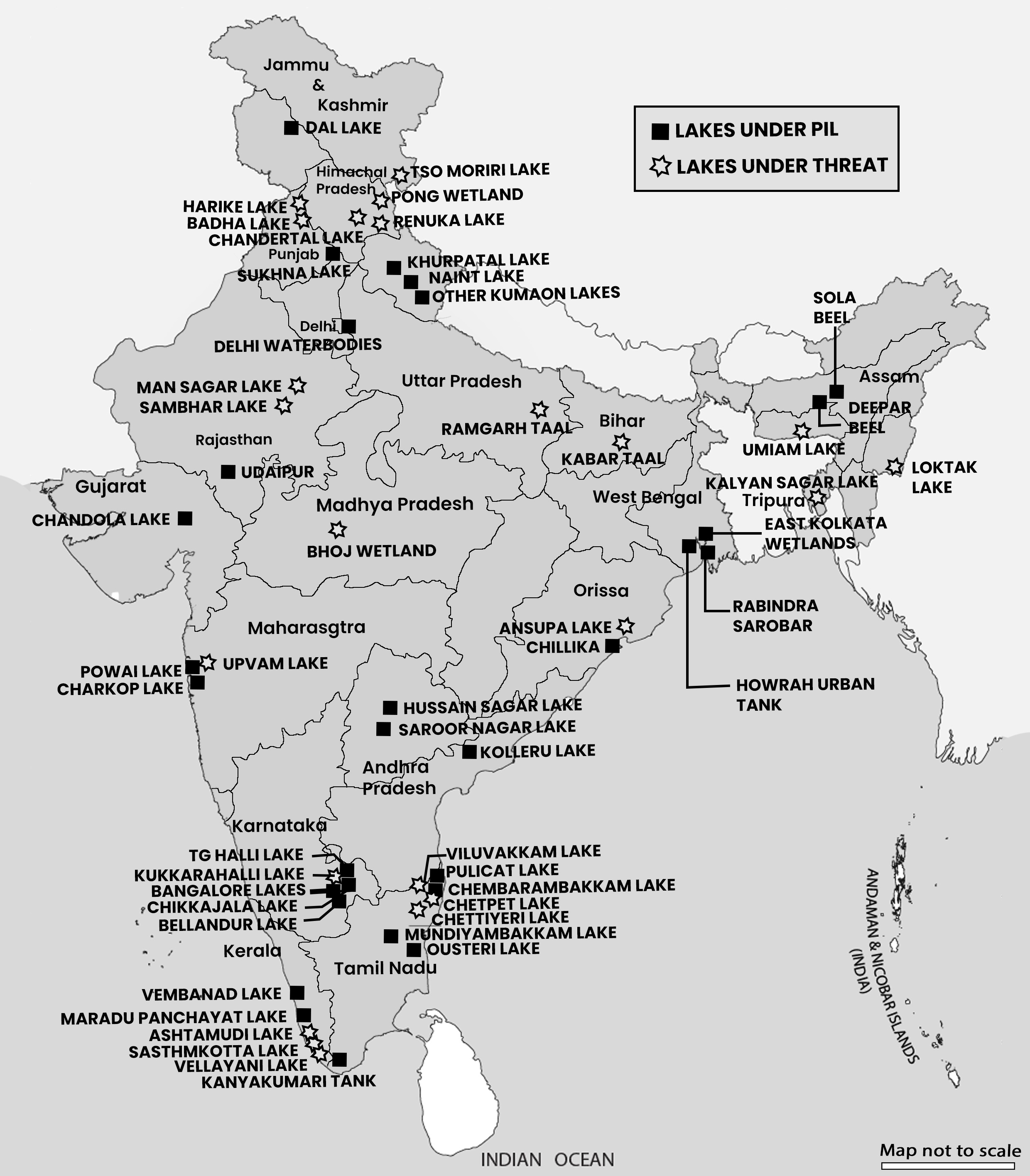
• Responsibilities:
• Central Government: Coordinates wetland conservation, provides guidelines, financial and technical assistance.
•
State Governments: Manage the wetlands, as land resources belong to the states.
NWCP:
• Aim: Conserve wetlands to prevent degradation
and ensure their wise use for local communities and biodiversity conservation.
• Objectives:
• Set policy guidelines.
• Provide financial assistance.
• Monitor implementation.
• Prepare an inventory of Indian wetlands.
Amrit Sarovar Programme
• Launch and Objective: Launched in April 2022, the mission aims to conserve water by developing or rejuvenating 75 Amrit Sarovars (ponds) in each district across India, totalling about 50,000 ponds.
• Collaborative Approach: Involves multiple ministries and organizations:
• Ministries: Rural Development, Jal Shakti, Culture, Panchayati Raj, Environment, Forest & Climate Change.
• Organization: Bhaskaracharya National Institute for Space Applications and Geo-informatics (BISAG-N).
• Other Ministries/Public Agencies: Ministry of Railways, Ministry of Road Transport & Highways for utilising soil/silt excavated from the ponds.
• Implementation:
• Carried out by states and districts.
• Utilises various schemes for funding and resources, including:
• Mahatma Gandhi National Rural Employment Guarantee Scheme.
• 15th Finance Commission Grants.
• Pradhan Mantri Krishi Sinchayee Yojana (Watershed Development Component, Har Khet ko Pani).
• States’ own schemes and Corporate Social Responsibility (CSR) funds.
• Focus Areas:
• Water conservation.
• People’s participation.
• Proper utilisation of soil from the ponds for infrastructural projects.
National Wetland Conservation Rules
• Overview: The Ministry of Environment, Forest and Climate Change (MoEF&CC) established the Wetlands (Conservation and Management) Rules, 2017 under the Environment (Protection) Act, 1986 to provide a regulatory framework for the conservation and management of wetlands in India.
• Purpose: These rules aim to conserve, manage, and maintain the ecological character of wetlands while allowing for their wise use.
• Legal and Institutional Strengthening:
• Legal Framework: Enhances legal measures for addressing environmental concerns.
•
Institutional Framework: Establishes State/ UT Wetland Authorities and a National Wetland Committee.
National Wetland Committee:
• Advisory Role: Guides state bodies on integrated wetland management using the wise-use principle.
• Progress Review: Monitors the integrated management of Ramsar Convention sites.
Implementation Guidelines:
• Support for State Governments/UT Administrations: Provides guidance on:
• Identifying wetlands for notification.
• Delineating wetlands and their zones of influence.
• Preparing required documents.
• Developing lists of activities to be regulated or permitted.
• Establishing and operating Wetlands Authorities.
Amrit Dharohar
Goal: Promote the unique conservation values of Ramsar Sites.
Purpose: Maintain a healthy and effectively managed network of Ramsar Sites that:
• Ensure water and food security.
• Protect landscapes from floods, droughts, cyclones, and other extreme events.
• Generate local employment and support livelihoods.
• Provide habitats for species of local, national, and international conservation significance.
• Maintain and enhance carbon sinks.
• Conserve and celebrate rich cultural heritage.
Focus and Activities:
• Exclusive Focus on Ramsar Sites: To demonstrate, replicate, and upscale successful conservation efforts to other important wetlands.
• Conservation and Cultural Heritage: Protect and promote unique conservation and cultural values.
• Nature Tourism: Create tourism opportunities and income generation for local communities.
• Optimal Use: Encourage sustainable use while maintaining the ecological character of wetlands.
• Biodiversity and Carbon Stock: Safeguard and enhance biological diversity and carbon storage.
• Integrated Management: Ensure sustained provision of a full range of ecosystem services through integrated management.
National Wetland Inventory Assessment Atlas
Purpose:
• The project, “National Wetland Inventory and Assessment (NWIA),” aims to create a detailed database of India’s wetlands.
• Categories and Mapping:
• Wetlands are categorised into 19 classes and mapped using satellite remote sensing data from the Indian Remote Sensing Satellite (IRS P6- LISS III sensor).
• Publication Details:
• This atlas includes information on India’s internationally important wetlands under the Ramsar Convention, presented through text, statistical tables, satellite images, maps, and ground photographs.
• Ramsar Criteria:
• Wetlands are identified based on nine criteria set by the Ramsar Convention, divided into two groups:
• Group A: Sites with representative, rare, or unique wetland types.
• Group B: Sites important for conserving biological diversity.
• Atlas Sections:
• The atlas is divided into five sections, providing comprehensive wetland information.
• Methodology:
• Uses four spectral bands of LISS III data (green, red, near infra-red, and short wave infra-red) to derive indices and information on water spread, turbidity, and aquatic vegetation.
• Includes data on water spread and turbidity during wet and dry seasons (post-monsoon and pre- monsoon).
• Accounts for the status of aquatic vegetation in two seasons.
• False Colour Composite (FCC):
• Shows satellite images (both seasons) with the derived wetland map to provide a visual representation of wetlands from remote sensing data and a synoptic view of the area.
Mangroves
Mangroves
Mangroves are shrubs or trees that grow in coastal salty or brackish water. They form tropical coastal vegetation and are found mainly between 30° N and 30° S latitude, with most areas near the equator. Mangroves evolved from various plant families over time, with the oldest fossils dating back 75 million years.
Adaptations - Mangroves are salt-tolerant (halophytes) and have special systems to filter salt and deal with waterlogged, low-oxygen mud. They thrive in the upper intertidal zone, where they are partially submerged in seawater.
Mangrove Habitat - The mangrove forest, or mangal, is a saline woodland or shrubland found in coastal areas with fine sediments and organic content. They tolerate various saline conditions, from slightly salty water to highly concentrated saltwater.
•
Global Presence and Loss - Using remote sensing technology, it was estimated that in 2010, mangroves covered 137,600 km² worldwide. However, from 1999 to 2019, there was a net loss of 3,700 km² of mangroves due to human activity, with some countries losing up to 0.70% annually.
• Restoration Importance - Mangroves are important because they support marine ecosystems, protect against tsunamis and extreme weather, and store carbon, helping to fight climate change. Successful restoration depends on local community involvement and ensuring the right conditions for mangrove growth.
• Approximately 40% of the world’s mangrove cover is in South and Southeast Asia, with India accounting for about 3% of this. The mangrove cover in India has increased by 54 square kilometers, totalling 4,975 square kilometers, which is 0.15% of the country’s total geographical area.
• West Bengal has the highest share of mangrove cover in India, followed by Gujarat and the Andaman and Nicobar Islands. South 24 Parganas district in West Bengal alone contributes significantly to the country’s mangrove cover, with the Sundarbans National Park located there.
| Region | %ShareofGlobal Mangrove Cove |
| South East Asia | 34% |
| South America | 15.5% |
| North and Central America | 15% |
| South Asia | 7% |
Adaptive Mechanism of Mangroves
Adaptations of Mangroves
Mangroves have evolved various physical and physiological adaptations to survive in harsh coastal conditions, including high salinity, lack of oxygen, and tidal inundation.
Here are some of their remarkable adaptations:
• Succulent Leaves: Mangroves have thick leaves that store water and minimize water loss through evaporation.
• Sunken Stomata: Stomata, tiny pores on leaves for gas exchange, are located deep within leaf surfaces to protect them from drying winds.
• Salt-Secreting Glands: Some mangroves have glands on their leaves that excrete excess salt, helping them cope with high salinity.
• Aerial Breathing Roots (Pneumatophores): These specialized roots emerge from the soil to absorb oxygen from the air, crucial for survival in waterlogged soils.
• Vivipary: Mangroves reproduce by germinating seeds while still attached to the parent tree, ensuring the seedlings have a head start in saline and oxygen-deficient environments.
• Stilt Roots: These roots spread out from the trunk and penetrate into adjacent soil, providing stability and anchorage in muddy substrates.
• Buttresses: Wide, supportive roots that extend from the base of the trunk help stabilize mangrove trees in shallow, waterlogged soils.
• Adventitious Roots: Roots that emerge above ground level from the main trunk, such as stilt roots, assist in stability and respiration.
These adaptations allow mangroves to thrive in challenging coastal habitats by overcoming obstacles like low oxygen levels, strong waves, and saltwater inundation. Their unique reproductive strategy of viviparity ensures successful germination in saline environments, contributing to their resilience and survival.
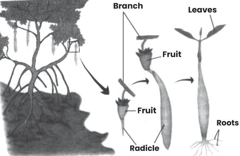
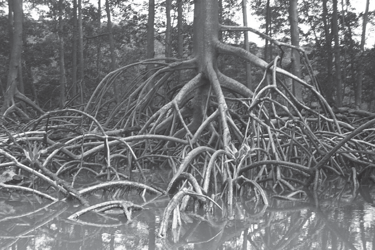
Mangroves in India
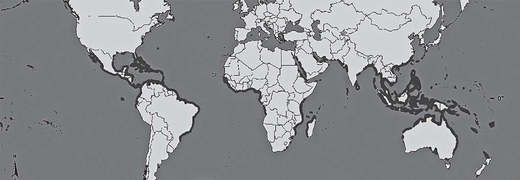
Importance of mangroves
Mangroves are vital ecosystems with many benefits:
• High Productivity: Mangroves are incredibly productive areas, supporting a diverse range of plant and animal life.
• Coastal Protection: Their intricate root systems help dissipate wave energy, shielding coastal areas from storms, tsunamis, and erosion.
• Pollution Filter: Mangroves act as natural filters, trapping pollutants like heavy metals and sediment, improving water quality.
• Carbon Sink: They absorb and store large amounts of carbon dioxide from the atmosphere, helping mitigate climate change.
• Nutrient Recycling: Mangroves facilitate the recycling of nutrients, enriching the surrounding environment.
• Sedimentation: Mangroves slow water flow, allowing sediment to settle and build up land, reducing coastal flooding.
• Habitat and Fisheries: They provide breeding grounds and shelter for a wide variety of fish and marine life, supporting fisheries and biodiversity.
• Livelihoods: Coastal communities rely on mangroves for resources like firewood, medicinal plants, and fish, sustaining their livelihoods.
• Building Material: Mangrove wood is valuable for construction, fencing, and fuel, providing essential resources for local communities.
Threats to Mangroves and Associated Consequences
• Agriculture and Aquaculture: Mangroves are often cleared for shrimp farming and other forms of aquaculture. This destroys their habitat and disrupts the delicate balance of the ecosystem.
• Hydrological Changes: Human activities like dam construction and irrigation alter the natural flow of water to mangroves. This disrupts their water supply and can lead to their decline.
• Eutrophication: Pollution from agricultural runoff and sewage can cause excessive nutrient buildup in mangrove waters, leading to the overgrowth of invasive species like water hyacinth, choking out native plants and animals.
• Overharvesting: Unsustainable harvesting of mangrove resources such as wood, fish, and shellfish can deplete their populations, disrupting the ecosystem and threatening local livelihoods.
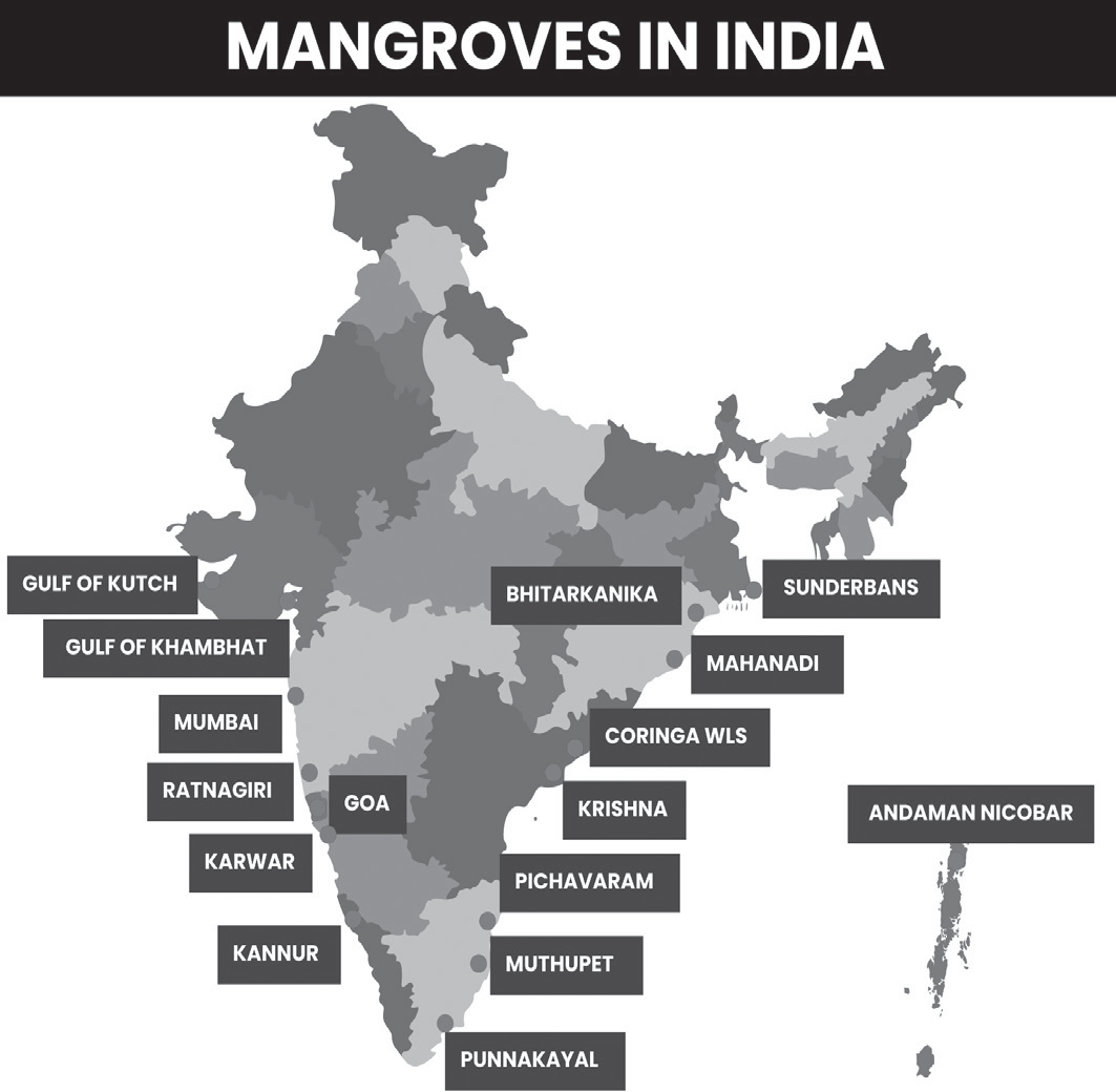
These threats endanger the health and survival of mangroves, disrupting their crucial role in protecting coastlines, supporting biodiversity, and sustaining local communities.
Consequences & Impact
Destroying mangroves can have serious consequences:
• Bioaccumulation & Biomagnification: Toxins can build up in the food chain, harming animals and humans.
• Loss of Biodiversity: Mangroves are rich ecosystems, and destroying them reduces habitat for numerous plant and animal species.
• Decline in Migratory Birds: Birds that rely on mangroves
for nesting and feeding, like the Siberian crane, may see their populations dwindle.
• Decrease in Fish and Marine Life: Mangroves are vital nurseries for fish and other marine creatures. Destroying them can reduce fish populations.
• Altered Water Balance: The balance between fresh and saltwater is disrupted, impacting the entire ecosystem.
• Increased Risk of Natural Disasters: Mangroves act as natural buffers against flooding, cyclones, and sea-level rise. Their destruction leaves coastlines vulnerable.
• Species Endangerment: Many species depend on mangroves for survival. Destroying them puts these species at risk of extinction.
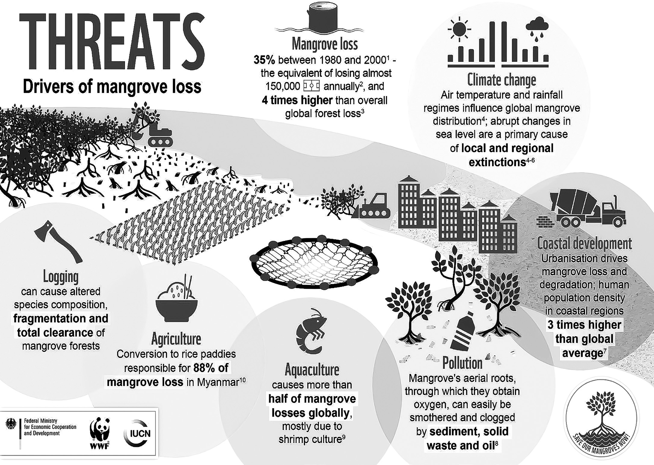
Measures to Protect Mangroves
• National Coastal Mission Programme: A government scheme to conserve and manage mangroves and coral reefs. It includes making annual plans for mangrove conservation in coastal areas.
• UNESCO Designated Sites: Mangroves are included in UNESCO Biosphere Reserves, World Heritage sites, and Global Geoparks, which helps in better understanding and conserving them.
•
International Society for Mangrove Ecosystem (ISME): An organization formed to study mangroves and promote their conservation and sustainable use.
• Blue Carbon Initiative: A global effort led by organizations like Conservation International and IUCN to combat climate change by protecting and restoring coastal ecosystems, including mangroves.
• International Day for the Conservation of the Mangrove Ecosystem: UNESCO celebrates this day on July 26
to raise awareness about mangrove conservation and sustainable management.
• Mangroves for the Future Initiative (MFF): An initiative by IUCN and UNDP to promote investment in coastal ecosystem conservation in countries like India, Indonesia, and Vietnam.
• National Mangrove Committee: A committee in India formed to advise the government on mangrove conservation and development.
•
Mangrove Alliance for Climate (MAC): A global initiative to educate people about the role of mangroves in combating climate change and to promote their conservation.
• MISHTI (Mangrove Initiative for Shoreline Habitats & Tangible Incomes): A new program in India to plant mangroves along the coastline and salt pan lands, with funding from various sources including MGNREGS and Campa Fund.