Whatsapp 88106-52225 For Details
Get Free IAS Booklet
Get Free IAS Booklet
IMPACT OF GLOBAL WARMING
Increased Frequency and Severity of Heatwaves
The increased frequency and severity of heatwaves, attributed to global warming, have resulted in devastating consequences in various regions around the world.
British Columbia, Washington, and Oregon experienced an unprecedented heatwave that claimed hundreds of lives. Australia, California, and Siberia have also faced deadly wildfires due to extreme heatwaves in recent years.
A heatwave is characterized by a prolonged period of excessively hot weather.
In India, the India Meteorological Department (IMD) declares heatwaves when the actual maximum temperature remains 45 C or higher, regardless of the normal maximum temperature.
Heatwaves can be caused by various factors, including the shifting of jet streams and Rossby waves in temperate regions, leading to the formation of heat domes. Local phenomena such as hot winds like loo, which affect the Gangetic Plains Region, can also contribute to heatwaves.
Anthropogenic causes, particularly global warming, have intensified heatwaves worldwide. The increased frequency and severity of heatwaves underscore the urgent need for mitigating climate change and implementing measures to adapt to extreme weather
events.
Global Warming and Heat Waves
Since 1900, the global average temperature has increased by approximately 1.3 C.
In India, this temperature rise has surpassed 2 C (More Pronounced Warming Trend).
With emissions continuing to rise globally, India is projected to experience more frequent and severe heatwaves compared to other parts of the world.
This trend is concerning as it poses significant risks to public health, agriculture, and ecosystems.
Studies conducted by the India Meteorological Department (IMD) and the Indian Institute of Tropical Meteorology (IITM) in Pune have provided evidence of the increasing frequency and severity of heatwaves in India over the past three decades.
Urban areas exacerbate the effects of heatwaves through the formation of Urban Heat Islands (UHIs), where temperatures in cities are significantly higher than in surrounding rural areas. The concentration of buildings, roads, and other heat-absorbing surfaces in cities amplifies
heat retention, intensifying the severity of heatwaves and their impact on urban populations.
As per State of the Global Climate 2025 of world meteorological organization, during 2015 to 2025 the Earth remain hottest on record
Urban Heat Islands
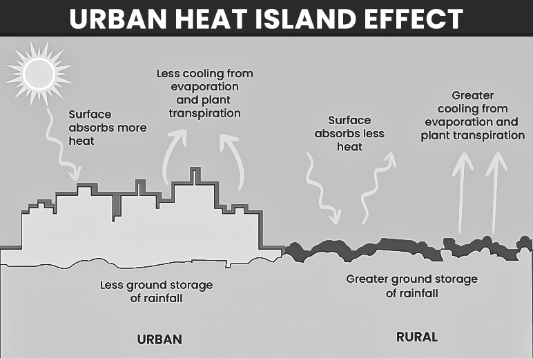
An urban heat island (UHI) refers to an urban or industrial area where temperatures are significantly higher than the surrounding rural areas, despite both areas sharing the same climate conditions. This phenomenon is primarily caused by human activities (anthropogenic reasons).
Causes Behind Urban Heat Islands
Concrete and asphalt, which have low albedo (reflectivity), replace natural vegetation and water bodies. This reduces evaporation and evapotranspiration.
Tall buildings offer more surface area for heat absorption.
High vehicle density in urban areas results in the release of heat from engines.
High pollution levels, including greenhouse gases like carbon dioxide (CO2) emitted from thermal power plants and vehicles, contribute to the heat island effect. These pollutants absorb outgoing infrared radiation, trapping heat in the atmosphere.
Cooling appliances such as air conditioners release heat into the surroundings, adding to the urban heat island effect.
Bad monsoons or limited rainfall result in less evaporation of water from vegetation and soil.
Urban heat islands at night
Urban heat islands at night occur when urban areas retain heat absorbed during the day and release it slowly overnight.
The dense network of buildings, roads, and other structures in cities absorbs and retains heat during the day. These structures, made of materials like concrete and asphalt, have high thermal mass, which means they store heat and release it slowly over time, even after the sun has set.
Urban areas often have fewer trees and green spaces compared to rural areas. Vegetation helps to cool the
surrounding air through evapotranspiration, but in urban environments, the lack of vegetation results in less cooling effect during the night.
Activities such as air conditioning, industrial processes, and vehicular traffic release heat into the urban environment. This additional heat contributes to higher temperatures in urban areas, particularly at night when there is less natural cooling from sunlight.
Urban areas tend to have higher levels of pollution, including particulate matter and greenhouse gases, which can trap heat in the atmosphere and contribute to warmer nighttime temperatures
Heat Domes
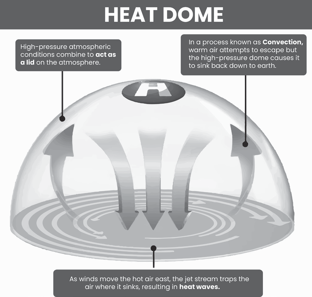
Heat domes are weather phenomena characterized by a dome-shaped area of high atmospheric pressure that traps hot air beneath it.
Heat domes develop when a large area of high pressure builds up in the atmosphere. This high-pressure system causes air to sink downward, resulting in compression and warming of the air as it descends toward the Earth’s surface.
As the air descends within the heat dome, it undergoes compression, which leads to an increase in temperature. This process contributes to the intensification of surface
temperatures within the affected region.
Heat domes often remain stationary or move very slowly, leading to prolonged periods of hot weather. Under the dome, the hot air becomes trapped, inhibiting the normal exchange of air and hindering the dissipation of heat.
The formation and behavior of heat domes are closely linked to the patterns of the jet stream. When the jet stream develops a large wave pattern known as Rossby waves, it can create conditions favorable for the formation and persistence of heat domes.
Climate change can exacerbate the conditions conducive to heat dome formation and intensification. Warmer atmospheric temperatures associated with climate change can contribute to the development of more intense and prolonged heat waves.
The recent extreme temperatures experienced in Lytton, British Columbia, and other regions are attributed to the presence of a heat dome.
Heat domes are like a lid trapping hot air over an area, leading to very hot weather. This can cause severe thunderstorms with lightning and heavy rain. In regions prone to wildfires, heat domes can make fires worse (wildfires).
Omega Block
An omega block is a weather pattern characterized by a blocking pattern in the atmosphere that disrupts the usual west-to-east movement of weather systems.
This pattern is named after the Greek letter omega ( ) because it resembles the shape of this letter on a weather map.
In an omega block, a high-pressure system, such as a heat dome, is situated between two low-pressure systems.
This configuration leads to prolonged periods of stagnant weather conditions, often resulting in extreme heat, as seen in Canada during the summer.
Effects of Heat Wave
Heat waves can lead to sunstroke, where the body temperature rises above 40 C, causing vital organ failure.
Heat waves can adversely affect mental health and reduce human productivity. The body functions optimally within a narrow range of body temperature (36-37.5 C).
Heat waves result in increased expenditure on cooling appliances, which creates a positive feedback mechanism exacerbating global warming. The cycle involves heatwaves leading to increased demand for cooling appliances, which in turn leads to more emissions, resulting in more severe heatwaves.
Heat waves can cause reduced biological activity and carbon sequestration in ecosystems.
Pyrocumulonimbus clouds
Pyrocumulonimbus clouds are formed during intense bushfires when the heat generated creates rising air currents. These rising air currents draw in surrounding air, forming a column of smoke and heat that can reach high altitudes.
As the rising air column cools in the upper atmosphere, it can form into a cumulonimbus cloud, similar to a thunderstorm cloud. This cloud can build up an electrical charge from the collisions of ice particles, leading to lightning strikes.
Pyrocumulonimbus clouds can lead to unpredictable changes in fire behavior, making firefighting efforts more challenging. The intense updrafts associated with these clouds can cause strong winds, which further fan the flames and accelerate the spread of the fire.
Lightning generated by pyrocumulonimbus clouds can ignite new fires, exacerbating the firefighting efforts and increasing the overall fire risk in the affected areas.
Wildfires and Zombie Fires Have Reached the Tundra Region due to Global Warming
Wildfires in the permafrost region of Siberia, south of the Arctic, have been relatively common. However, in 2020, wildfires occurred well above the Arctic Circle in the tundra region, which is not typically known for large wildfires.
This phenomenon is attributed to the unprecedented drying up of tundra vegetation, including moss, grass, and dwarf shrubs, caused by rising temperatures and changing climate patterns.
Also, “zombie fires,” also known as holdover fires, are becoming more frequent in the once-frozen tundra north of the Arctic Circle. Zombie fires are fires from previous growing seasons that can smoulder under the ground, particularly in carbon-rich peat, and reignite when conditions are favorable.
Concerns
The fires and record temperatures in the tundra region have the potential to transform the carbon sink into a carbon source. This means that instead of absorbing carbon dioxide from the atmosphere, the burning vegetation and thawing permafrost release stored carbon dioxide.
Marine Heat Waves
Marine heatwaves refer to instances when ocean
temperatures in a specific location are exceptionally warm for a prolonged period, regardless of the time of year.
These events can happen during both summer and winter seasons and can have significant effects on marine ecosystems and global weather patterns.
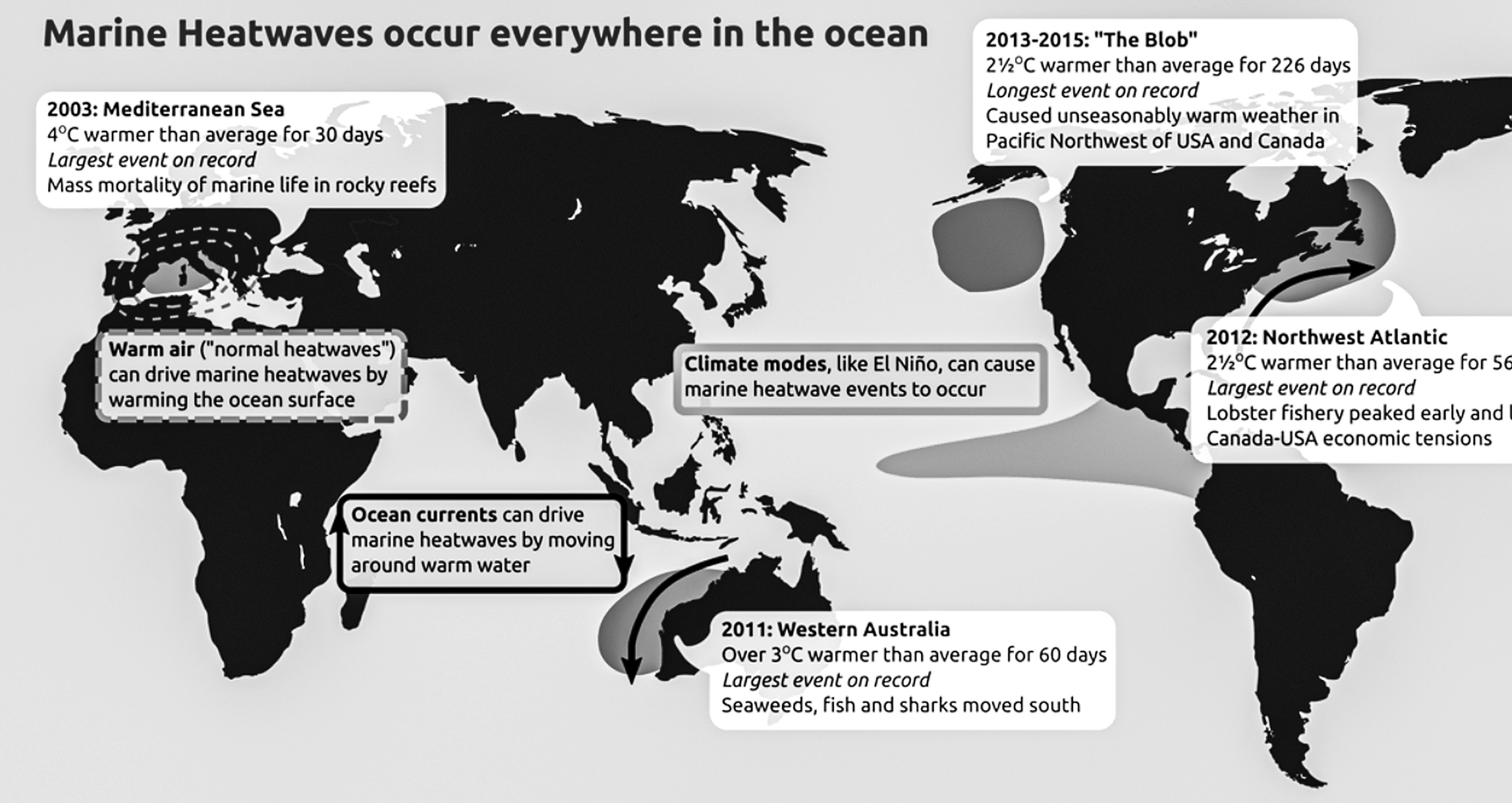
IPCC Special Report on the Ocean and Cryosphere in a Changing Climate (SROCC) on Marine Heat Waves
Oceans are currently experiencing unprecedented conditions characterized by increased temperatures, ocean acidification, marine heatwaves and more frequent extreme El Niño and La Niña events.
Communities closely connected to coastal environments, small island nations, polar regions, and high mountains are particularly vulnerable to changes such as rising sea levels and shrinking glaciers. Other areas are also affected through extreme weather events exacerbated by ocean warming.
Marine heatwaves have become twice as frequent over the past four decades and are lasting longer periods.
Human activities are identified as the primary cause of 84 to 90 percent of marine heatwaves that occurred in the last decade.
By 2081, the frequency of marine heatwaves could increase by 20 to 50 times.
Impact on marine productivity
Marine heatwaves often lead to large-scale coral bleaching events, where corals expel the algae living in their tissues, turning them white. Recovery from coral bleaching can take more than 15 years.
Marine heatwaves can reduce the mixing between water layers, limiting the supply of oxygen and nutrients essential for marine life. This reduction in nutrient
availability can negatively impact the growth and survival of various marine organisms.
In some cases, marine heatwaves can promote the growth of toxin-producing algae while suppressing the growth of small organisms at the base of the ocean food chain. This imbalance can disrupt marine ecosystems and lead to harmful algal blooms, which can have detrimental effects on marine life and human health.
Impact on weather patterns
The direct cause of marine heatwaves is attributed to weak winds, which can lead to prolonged periods of unusually warm ocean temperatures. However, the impact of marine heatwaves extends beyond the immediate oceanic conditions.
Marine heatwaves can have a significant influence on global wind circulation patterns and ocean currents. For example, the weakening of winds can disrupt ocean currents and alter the distribution of heat and nutrients within the ocean.
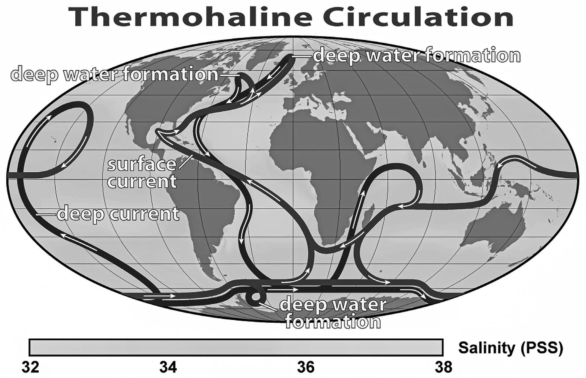
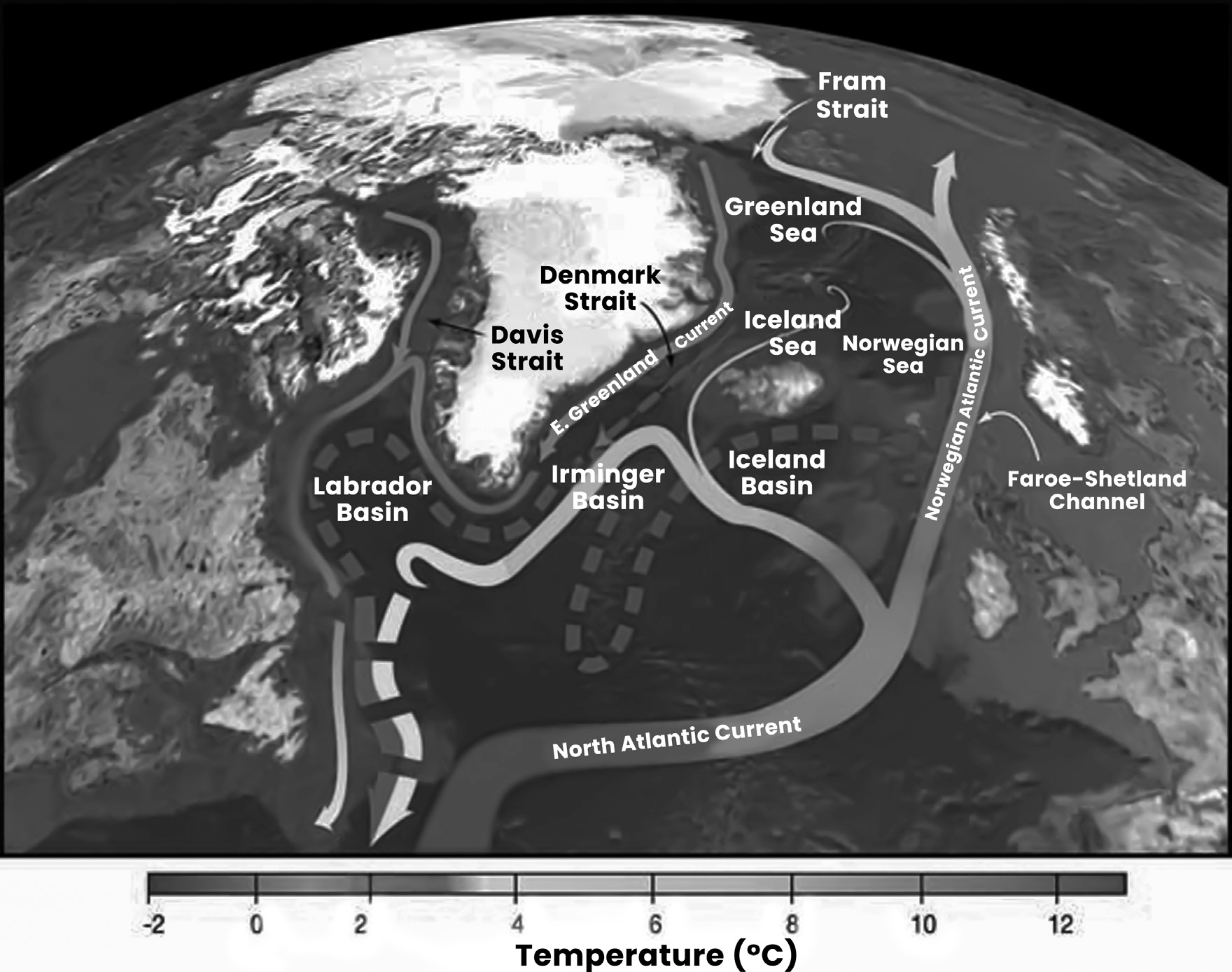
Impact on Atlantic Meridional Overturning Circulation (AMOC): The IPCC report highlights that the AMOC, responsible for the circulation of warm and cold waters in the Atlantic Ocean, has already weakened.
Further weakening of the AMOC could have several consequences
Decreased marine productivity in the North Atlantic.
Increased storm activity in Northern Europe.
Reduction in Sahelian and South Asian summer rainfall.
Changes in the frequency and intensity of tropical cyclones in the Atlantic.
Regional sea level rise along the northeast coast of North America.
More severe cyclonic storms
The IPCC has noted a concerning trend of an increasing percentage of category 4 and 5 cyclonic storms occurring annually.
These intense storms are fueled by warm ocean waters, which provide the moisture and energy necessary for their sustenance and intensification.
Shrinking Cryosphere
The cryosphere encompasses areas of snow or ice that experience temperatures below 0 C for at least part of the year.
It includes continental ice sheets, glaciers, ice caps, permafrost, and frozen parts of oceans, rivers, and lakes.
Studies, such as one conducted by the IUCN, warn that glaciers in many natural World Heritage sites, like the Khumbu Glacier in the Himalayas, could vanish entirely by 2100 if current emission rates persist.
The study predicts the extinction of glaciers in 21 out of 46 natural World Heritage sites that currently have glaciers (It shows the rapid decline of these ice formations due to global warming).
Role of Cryosphere
Snow and ice, with their high albedo, reflect a significant amount of solar heat, contributing to the Earth’s heat budget and helping to regulate global temperatures.
Glaciers and snow-covered mountains serve as vital freshwater reservoirs, supplying water to many regions around the world.
The cryosphere is highly sensitive to shifts in climate, making it a valuable indicator of past global climate changes. By studying the layers of ice, scientists can gain insights into historical climate variations.
Consequences of Shrinking Cryosphere (Glaciers)
Water scarcity and potential conflicts over water resources among nations could arise as glaciers, a major freshwater source, continue to shrink.
Loss of ecologically rich coastal wetlands due to rising sea levels and coastal inundation.
Displacement of coastal populations as major cities face submergence from sea level rise, particularly impacting Small Island Developing States.
Disruption of major weather patterns due to changes in the cryosphere’s behavior, leading to unpredictable climate phenomena.
Thawing of snow and ice may expand arable land in high-latitude regions but decrease it along coastlines due to sea level rise and saltwater intrusion.
Coastal groundwater resources will be affected by salinization, reducing freshwater availability for communities.
Reduced hydroelectric power generation due to changes
in glacier behavior may increase reliance on fossil fuels for energy.
Habitat loss and ecosystem disruption could lead to the decline or extinction of various animal species.
Surge-Type Glaciers and Disasters
Surge-type glaciers are characterized by periods of rapid advancement in volume and length, contrary to the overall trend of glacier retreat observed in most glaciers.
These glaciers exhibit cyclical flow instabilities, meaning they do not flow at a constant speed but rather experience periods of accelerated movement.
When surge-type glaciers break or collapse due to factors such as global warming, they can trigger catastrophic glacial lake outburst floods, posing a significant threat to surrounding areas.
Small Island Developing States (SIDS) are the Biggest Losers
Small Island Developing States (SIDS) are remote islands that are particularly vulnerable to environmental challenges, including climate change, and are generally small in size.
Recognized as a distinct group of developing countries in 1992 at the UN Conference on Environment and Development, SIDS face unique challenges due to their geographical characteristics.
Many SIDS are coral islands situated on shallow atolls, making them highly susceptible to sea level rise and associated impacts such as coastal erosion and inundation.
In 2016, the Marshall Islands took legal action against India, Pakistan, and Britain in the International Court of Justice, alleging their failure to halt the nuclear arms race, highlighting the existential threats faced by SIDS.
Barbados Programme of Action (1994)
The United Nations Programme of Action on the Sustainable Development of Small Island Developing States, commonly known as the Barbados Program of Action (BPOA), is a policy document.
It addresses the economic, environmental, and social developmental vulnerabilities faced by islands and proposes a strategy to mitigate those vulnerabilities.
The BPOA is the only internationally approved program specifically tailored to the needs of Small Island Developing States (SIDS).
Mauritius Strategy (2005)
The Mauritius Strategy is a 10-year comprehensive review of the Barbados Programme of Action (BPOA).
Its outcome resulted in the adoption of the Mauritius Strategy for the Further Implementation of the BPOA, aiming to enhance the implementation of the BPOA and address emerging challenges faced by SIDS.
Sea Level Change
Sea level change refers to fluctuations in the average level of the Earth’s oceans over an extended period.
PROCESSES THAT CAUSE CHANGE IN SEA LEVEL
Eustatic Changes
Eustatic changes occur when the volume of seawater changes globally.
Factors include global warming leading to the melting of ice sheets (raising sea levels) or ice ages (lowering sea levels), and changes in the volume of mid-oceanic ridges.
Tectonic Changes
Tectonic changes occur due to alterations in the level of land.
Isostatic changes result from the addition or removal of a load. For instance, during ice ages, landmasses may subside due to the weight of glacial ice. On the other hand, landmasses may rise as glacial ice melts.
Epeirogenic movement involves broad-scale tilting of continents, which can cause one part of the continent to rise while another part may subside.
Orogenic movement, such as mountain building, leads to the formation of high mountains and can result in an apparent decrease in sea level.
Changes in Global Sea Level
Typically, sea levels fluctuate by 5-6 cm throughout the year due to seasonal changes.
Short-term sea level changes can be influenced by various factors
Marine Water Density: Sea water density is affected by temperature and salinity. Colder temperatures and higher salinity lead to denser water and lower sea levels.
Atmospheric Pressure: Low atmospheric pressure can result in higher local sea levels, while high pressure can lead to lower sea levels. For example, storm surges can cause temporary increases in sea level.
Velocity of Ocean Currents: Fast-flowing Ocean currents, especially when they follow a curved path, can cause sea levels to rise on their outer edges. This phenomenon can result in a difference of up to 18 cm in sea level between
the two sides of a fast-flowing current.
Ice Formation and Melting: During winter, ocean water freezes into ice caps in the northern and southern hemispheres, causing a decrease in sea level. However, when this ice melts, it contributes to rising sea levels.
Piling up of Water Along Windward Coasts: Water can be driven towards coastal regions by air masses, leading to local increases in sea level. For example, during monsoon months, sea levels may rise in regions like south and east
Asia due to the landward movement of air masses.
The twentieth century has observed short-term global sea level rise due to the following factors.
Anthropogenic activities, particularly the emission of greenhouse gases, have led to global warming. This warming has caused thermal expansion of ocean water, resulting in a rise in sea levels by approximately 10 to 15 cm ov
er the past century.
The melting of about 3 percent of the total volume of ice sheets in Antarctica has also contributed, albeit to a lesser extent, to the global sea level rise observed during the twentieth century.
Long-Term Sea Level Changes
Global sea level changes exceeding 100 meters are only possible if major ice sheets melt or if there are substantial alterations in the volume of the world’s mid-oceanic ridges. These changes would have profound and long-lasting
impacts on global sea levels.
Importance of Understanding Sea Level Changes
Sea level changes provide crucial evidence of climate change over geological time scales, aiding in understanding past climatic conditions.
Studying sea level changes helps in estimating the rates of tectonic upliftment during different geological periods.
It helps in assessing the suitability of coastal locations for various activities such as industrial and agricultural development, tourism, and residential settlements.
Knowledge of sea level changes is essential for designing and implementing coastal protection measures such as building dykes and embankments to mitigate the impacts of rising sea levels on low-lying areas.
Understanding sea level changes enables the mapping of areas susceptible to storm surges and periodic flooding, allowing for better preparedness and planning for future events.
Identifying areas prone to submergence in the future can help in strategically locating renewable energy infrastructure such as tidal power generation plants, maximizing their efficiency and sustainability.
Sea Level Rise and Coastal Flooding due to Global Warming
The World Meteorological Organization (WMO) has attributed the current increase in sea surface temperatures worldwide to global warming, which is primarily driven by human activities such as the burning of fossil fuels and deforestation.
According to the Intergovernmental Panel on Climate Change (IPCC), sea levels could rise by 60 to 110 cm if greenhouse gas emissions continue to increase at current
rates.
Recognizing the seriousness of sea level rise, the ‘Oceans and Coastal Areas Programme Activity Centre’ was established in 1987 under the United Nations Environment Programme (UNEP). Its purpose is to identify countries
facing the highest risks of submergence due to rising sea levels and to develop strategies for addressing this threat.
IPCC: Extreme floods to increase economic loss 166 times in coastal megacities
Economic losses from extreme flooding are projected to increase dramatically by 2050, with a staggering 166- fold surge if coastal megacities fail to adapt to climate change.
Mumbai, India’s financial hub, is among the cities expected to bear the brunt of these escalating flood risks, emphasizing the need for adaptive strategies in vulnerable urban areas.
Over half of the global population resides in cities, many of which are situated in low-lying coastal regions prone to flooding.
Vulnerable Areas in India
A similar study says
36 million people living along the Indian coastlines are at risk of exposure to flooding by 2050, highlighting the urgent need for resilience-building efforts in coastal communities.
Contrary to earlier estimates, approximately 300 million people worldwide currently reside in areas below the annual coastal flood line, significantly increasing the global population at risk. The most vulnerable regions include China, Bangladesh, India, Vietnam, Indonesia, and Thailand, with China alone accounting for 43 million individuals at risk.
Numerous major cities, including Bangkok, Hong Kong, Shanghai, Taizhou, Surabaya, Dhaka, Mumbai, Ho Chi Minh City, and Osaka, are projected to experience significant flooding.
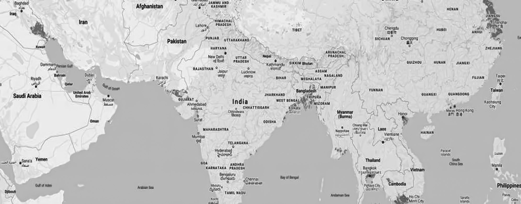
Bhuj, Jamnagar, Porbandar, Surat, Bharuch, and Mumbai face heightened vulnerability to rising sea levels, particularly along India’s western coastline. Similarly, significant portions of the coastline in West Bengal and Odisha, located on the eastern side of India, are also under threat from rising sea levels.
Regional Sea Level Rise (SLR)
Regional Sea Level Rise (SLR) refers to the uneven increase in sea levels observed across different regions of the world, as opposed to a uniform rise globally. While approximately 68% of the global coastal areas are susceptible to flooding, around 32% of this risk can be attributed to regional SLR.
Unlike global SLR, which represents the overall rise in sea levels averaged across the planet, regional SLR varies depending on factors such as the gravitational pull of
polar ice sheets and local geological conditions.
One example of regional SLR variation is the gravitational effect of polar ice sheets, which can cause sea levels to
rise unevenly across different regions. This means that some areas may experience higher or lower rates of SLR compared to the global average.
What are some ways of protecting against SLR?
Indonesia’s government initiated the construction of a coastal development project known as the Giant Sea Wall, or “Giant Garuda,” in 2014. This project aims to build a massive barrier along the coastline to protect coastal areas from the impacts of rising sea levels and coastal erosion.
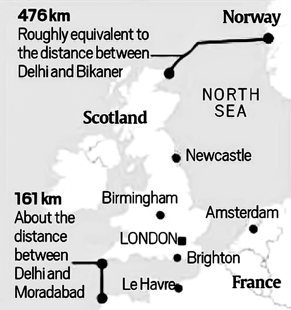
Northern European Enclosure Dam (NEED): The NEED project proposes the construction of two dams with a combined length of 637 km to enclose the entire North Sea region. This ambitious infrastructure project aims to protect 25 million people and important economic regions in Northern Europe from the threat of SLR caused by climate change. Similar mega enclosures could also be considered for other vulnerable regions, such as the Persian Gulf, the Mediterranean Sea, the Baltic Sea, the Irish Sea, and the Red Sea.
New Sea Routes in The Arctic Region
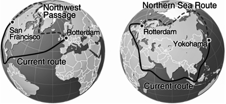
The warming of the Arctic region is accelerating at a rate twice as fast as the global average. As a result, the melting of ice in this region is gradually opening up new sea routes, such as the Northern Sea Route (NSR), which connects the North Atlantic to the North Pacific through
a shorter polar arc.
It is anticipated that by 2050, the NSR could become ice- free during the summer months (facilitating maritime navigation and trade).
However, the consequences of this warming trend extend beyond the opening of new sea routes. The loss of ice and the warming waters in the Arctic region are expected to have significant impacts on various environmental factors, including sea levels, salinity levels, and precipitation patterns.
Additionally, the changing climate is leading to ecological transformations, such as the return of tundra to swampy terrain, loss of forest cover, and the thawing of permafrost. These changes are exacerbating the release of carbon stored in the soil, contributing to greenhouse gas emissions.
Furthermore, the increased frequency and severity of wildfires in interior Canada and Russia are further compounding the environmental challenges faced by the region.
Tropical Cyclones are Becoming More Severe
Tropical cyclones are becoming more severe due to several factors, primarily linked to rising sea surface temperatures.
These storms require a minimum sea surface temperature of 26.5 C to form, with the most intense storms needing even warmer temperatures of 28-29 C.
The increasing frequency of high-intensity storms has been correlated with sea surface temperatures exceeding 30 C.
In the South Indian Ocean, where temperatures historically reached 26.5 C, they are now rising to 30- 32 C. This temperature rise contributed to the devastating Cyclone Idai in March 2019, which caused over 1300 casualties in the South-West Indian Ocean basin (South- East Africa).
Moreover, regions farther from the equator are experiencing more frequent temperatures exceeding the 24-26 C threshold, expanding the range where tropical cyclones can form. These conditions are compounded by global climate phenomena such as El Niño, Indian Ocean Dipole, Southern Annular Mode, and Madden- Julian Oscillation, all of which are influenced by global warming.
The number and intensity of tropical cyclones is increasing in the Arabian Sea
Traditionally, nearly 50% of storms in the Arabian Sea dissipate due to the presence of the Findlater/ Somali Current, which brings colder water to the west- central and north Arabian Sea. This local upwelling creates conditions unfavorable for sustained cyclonic development.
However, the Arabian Sea is experiencing rapid warming, which is altering this historical pattern. Warmer sea surface temperatures are becoming more prevalent, particularly in areas previously affected by cold water barriers. This warming trend is conducive to the development and sustenance of cyclonic storms.
The warming of the Arabian Sea is leading to an increase in cyclone activity and associated excessive rainfall. This excessive rainfall over the sea can reduce moisture content in monsoon winds.
Climate models indicate that a significant portion (64%) of the increased cyclone risk in the Arabian Sea can be attributed to climate change. As global temperatures rise, the Arabian Sea is expected to continue heating, further influencing cyclone dynamics and associated weather patterns.
Increased occurrence of Severe cyclonic storms
Previously, the Arabian Sea experienced an extremely severe cyclone roughly once every four to five years. This frequency was relatively low compared to other regions
prone to cyclonic activity.
However, there has been a noticeable increase in the frequency of high-intensity cyclones in the Arabian Sea in recent years. Instead of occurring once every few years, the region is now experiencing multiple extremely severe cyclones within shorter time intervals.
For instance, between 1998 and 2013, a span of just 15 years, the Arabian Sea witnessed the origin of five extremely severe cyclones.
Changing path
Traditionally, tropical cyclones in the Arabian Sea primarily affected the western coast of India, particularly the state of Gujarat. The coastal regions of Gujarat were often the main areas impacted by these cyclones.
However, over the past decade, there has been a noticeable shift in cyclone paths, leading to Kerala and Karnataka becoming more vulnerable to cyclonic activity. These states, located further south along the western coast of India, have experienced an increased frequency of cyclones making landfall or passing nearby.
Several factors may contribute to this changing trend. Shifts in atmospheric circulation patterns, changes in sea surface temperatures, and alterations in the intensity and tracks of cyclones due to climate change could all play a role in redirecting cyclone paths toward Kerala and Karnataka.
Deterioration of Carbon sinks
The deterioration of carbon sinks, particularly in high latitude forests such as the taiga and tundra areas, is a concerning phenomenon with significant implications for global carbon balance and climate change.
High latitude forests, including those found in the taiga and tundra regions, store substantial amounts of carbon. These forests often contain dense vegetation and organic soils that sequester carbon over long periods.
Approximately one-third of the world’s soil-bound carbon is located in taiga and tundra areas. This carbon is stored within the soil and vegetation of these ecosystems, contributing to their role as significant carbon sinks.
The melting of permafrost, a characteristic feature of tundra regions, is accelerated by global warming. As permafrost thaws, previously frozen organic matter decomposes, releasing carbon dioxide and methane into the atmosphere. This process contributes to the amplification of greenhouse gas concentrations and further exacerbates global warming.
In the past, tundra ecosystems acted as carbon sinks, absorbing more carbon dioxide from the atmosphere than they released. However, due to the effects of global warming, including permafrost thawing and increased microbial activity, these areas are transitioning into carbon sources. This shift results in a positive feedback loop, where the release of carbon from thawing permafrost
leads to further warming, exacerbating the process.
Carbon Dioxide Fertilization
Carbon dioxide fertilization refers to the process by which increased concentrations of atmospheric CO2 stimulate plant growth and enhance vegetation density.
Rising levels of atmospheric CO2 have led to significant greening of Earth’s vegetated lands. This greening manifests as an increase in the density and coverage of leaves on plants and trees.
Elevated CO2 concentrations promote photosynthesis, the process by which plants convert CO2 and sunlight into energy. As a result, plants experience accelerated growth rates and may produce more foliage.
Carbon dioxide fertilization is the primary driver behind approximately 70 percent of the observed greening effect.
Other factors contributing to the greening effect include nitrogen, accounting for about 9 percent of the effect, as well as changes in land cover, climate, precipitation, and sunlight.
While initially beneficial for plant growth, the fertilization effect of elevated CO2 concentrations may diminish over time as plants acclimatize to these conditions. This means that the extent to which plant growth is stimulated by CO2 may decrease as plants adjust to the elevated levels.
While carbon dioxide fertilization may offer short-term benefits for plant growth and vegetation density, the long-term implications are concerning. The continued rise in CO2 levels contributes to climate change, with detrimental effects on ecosystems, biodiversity, and overall environmental health.
Carbon Dioxide Fertilization is increasing carbon sink on land
Each year, approximately half of the 10 billion tons of carbon emitted into the atmosphere from human activities is temporarily stored. Roughly equal portions of this stored carbon are absorbed by the oceans and by plants on land.
Studies conducted since the 1980s have consistently reported an expanding carbon sink on land. This trend aligns with the concept of a greening Earth, wherein rising atmospheric CO2 levels stimulate plant growth and enhance vegetation density.
The observed increase in the carbon sink on land is entirely consistent with the greening of Earth’s vegetated areas, which is driven by carbon dioxide fertilization. As plants absorb more CO2 from the atmosphere through photosynthesis, they store carbon in their biomass and in the soil, effectively acting as a carbon sink.
Climate Migrants
The National Sample Survey Office (NSSO) 2007-08 report on migration in India identified natural disasters
as a major driver of migration, with approximately
13 out of every 1,000 migrants attributing their movement to such events (This shows the long- standing connection between environmental factors and human migration).
Environmental migrants are individuals who are displaced due to adverse changes in their local environment, which can include factors such as deforestation, desertification, and land degradation.
A subset of environmental migrants, climate migrants are those who are forced to relocate as a direct result of climate change impacts. Examples include individuals displaced by sea level rise in vulnerable coastal regions like the Sundarbans, floods in river basins such as the Ganges and Brahmaputra, and droughts in areas like central India, Vidarbha, Telangana, and Rayalaseema.
The displacement or increase in migration resulting from climate-related disasters raises concerns about various societal challenges. These include the risk of human trafficking, conflicts over resources in destination areas, and increased pressure on already strained infrastructure and services.
Addressing the needs of climate migrants requires comprehensive policies and planning at local, national, and international levels. This may involve measures to enhance resilience in vulnerable communities, facilitate adaptation strategies, and ensure the protection of human rights for those affected by climate-induced displacement.
OZONE HOLE DEPLETION
National & International Measures to Regulate Ozone Depleting Substances
Vienna Convention for the Protection of the Ozone Layer
The Vienna Convention for the Protection of the Ozone Layer, agreed upon in 1985, was a significant milestone in global environmental governance.
The Vienna Convention set up a framework for nations to monitor and report on ozone depletion. This involved the establishment of mechanisms for tracking atmospheric ozone levels, as well as the development of methodologies for assessing the extent of ozone depletion.
One of the key features of the Vienna Convention was its provision for the development of protocols aimed at addressing ozone depletion more effectively. While the Convention itself was not legally binding, it provided the groundwork for subsequent agreements that would carry legally binding obligations.
Montreal Protocol on Substances that Deplete the Ozone Layer
The Montreal Protocol on Substances that Deplete the Ozone Layer, established in 1987 under the umbrella of the Vienna Convention, is a landmark international agreement that has played a critical role in protecting the Earth’s ozone layer.
The Montreal Protocol facilitates international collaboration aimed at reversing the rapid decline in atmospheric concentrations of stratospheric ozone, particularly the “good ozone” found in the ozone layer. By bringing together countries from around the world, the protocol encourages collective action to address this pressing environmental issue.
One of the key provisions of the Montreal Protocol is the agreement among participating countries to phase out the production and consumption of certain chemicals known to deplete the ozone layer.
The Montreal Protocol is notable for achieving universal ratification, with 197 parties, making it the first and only global environmental treaty to achieve such widespread acceptance.
As a result of the concerted efforts made under the Montreal Protocol, there have been observable improvements in the ozone layer. For instance, the ozone hole over Antarctica, which was a major concern in the late 20th century, has shown signs of recovery.
Climate projections indicate that, as a result of the measures implemented under the Montreal Protocol, the ozone layer is expected to recover to 1980 levels between 2050 and 2070.
Compliance
Despite the international ban on the production and use of CFC-11 under the Montreal Protocol, China has been a major contributor to its emissions.
CFC-11 is a type of chlorofluorocarbon (CFC), which has been prohibited for most purposes since the Montreal Protocol was enacted in 1987. China, as a signatory to this agreement, committed to stopping the production of CFC-11 by 2010.
However, it has been found that some Chinese foam manufacturers continue to use CFC-11 illegally, despite cheaper alternatives being available. These manufacturers choose to use CFC-11 to save money, even though it is against the law and poses environmental risks.
Although there has been a reduction in the atmospheric concentration of CFC-11, it still contributes significantly to ozone depletion.
Kigali Amendment to Montreal Protocol 2016
The Kigali Amendment to the Montreal Protocol, established in 2016 during the 28th meeting of the Parties held in Kigali, Rwanda, is an international agreement signed by representatives from 197 nations.
This amendment targets the reduction of hydrofluorocarbons (HFCs), potent greenhouse gases widely used in air conditioners (ACs), among other applications.
If not substituted, ACs alone could contribute an additional 0.4 C of warming by the end of the century.
Additionally, the widespread use of ACs exacerbates the Urban Heat Island effect, making cities less hospitable, especially for disadvantaged populations.
Under the Kigali Amendment, parties to the agreement are expected to cut down the production and use of HFCs by approximately 80-85% compared to their respective baselines by 2045. This reduction is projected to help limit the global average temperature increase to 0.5 C by 2100.
The Kigali Amendment is a legally binding agreement among signatory parties, with mechanisms in place to address non-compliance. It officially became effective on January 1, 2019.
Hydrofluorocarbons (HFCs)
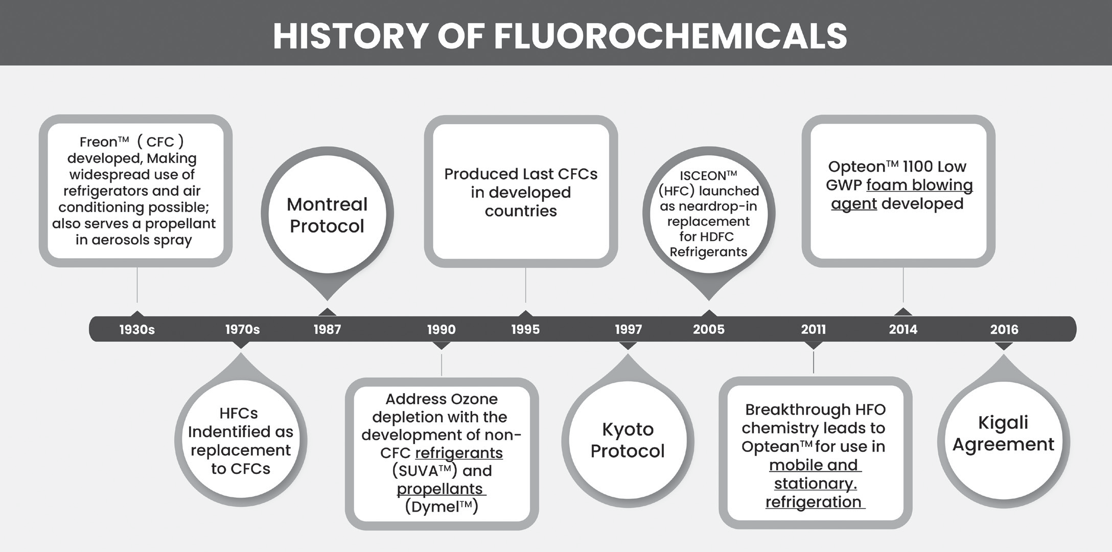
Hydrofluorocarbons (HFCs) have been utilized as substitutes for chlorofluorocarbons (CFCs) and hydrochlorofluorocarbons (HCFCs) since they do not harm the ozone layer.
However, despite this advantage, HFCs are potent greenhouse gases with a significant potential to contribute to global warming.
India’s position
India has adopted a relatively relaxed schedule regarding the reduction of hydrofluorocarbons (HFCs) because its consumption of HFCs is only 3% compared to larger consumers such as the USA (37%) and China (25%). This means that India’s contribution to the global use of HFCs is comparatively lower, so it has negotiated for a less stringent timeline for reducing its HFC consumption.
HFO Alternatives to HFCs
HFO stands for hydrofluoro olefin.
HFO refrigerants are made up of hydrogen, fluorine, and carbon atoms, but they contain at least one double bond between the carbon atoms.
Comparison: CFCs, HCFCs, HFCs & HFOs
| Fluorochemical | Ozone Depleting Potential | Global Warming Potential |
| Chlorofluorocarbons (CFCs) | High | High |
| Hydrochlorofluorocarbons (HCFCs) | Low | High |
| Hydrofluorocarbons (HFCs) | Zero | High |
| Hydrofluoroolefin (HFOs) | Zero | Very Low |
The Ozone Depleting Substances (ODS) Rules
The Ozone Depleting Substances (ODS) Rules are established under the jurisdiction of the Environment (Protection) Act. These rules outline deadlines for phasing out various ODSs and regulate the production, trade, import, and export of ODSs and products containing them.
The use of CFCs in manufacturing various products,
except for metered dose inhalers and other medical purposes, was prohibited after January 1, 2003.
Similarly, the use of halons was prohibited after January 1, 2001, except for essential purposes.
Other ODSs like carbon tetrachloride, methyl chloroform, and CFCs for metered dose inhalers could be used until January 1, 2010.
The use of methyl bromide was allowed until January 1, 2015.
HCFCs, which serve as interim substitutes for CFCs, are permitted for use until January 1, 2040.
India phases out Ozone Depleting HCFC-141b
Indiahas successfully phased out Hyd rochlorofluorocarbon (HCFC)-141b, a highly potent ozone depleting chemical commonly used in foam manufacturing, particularly in the production of rigid polyurethane (PU) foams.
This chemical is crucially linked to various economic sectors such as building construction, cold storages, cold chain infrastructure, automobiles, and commercial refrigeration.
Under the Ozone Depleting Substances (Regulation and Control) Amendment Rules, 2019, issued under the Environment (Protection) Act, 1986, HCFC-141b was prohibited from use starting January 1, 2020.
Since HCFC-141b is not produced domestically in India, all domestic requirements were met through imports. However, with the enactment of the Amendment Rules in 2019, the import of HCFC-141b was completely prohibited, thereby ensuring a comprehensive phase-out of this ozone-depleting chemical from India.
This accomplishment marks a significant milestone for India as it becomes one of the first developing countries (Article 5 parties) under the Montreal Protocol to achieve a complete phase-out of HCFC-141b in the foam sector at such a large scale.
Closure of Hindustan Fluorocarbons Limited (HFL)
The Government of India (GOI) approved the closure of Hindustan Fluorocarbons Limited (HFL).
HFL was a subsidiary of Hindustan Organic Chemicals Ltd., operating under the Department of Chemicals & Petrochemicals. The company was involved in the manufacturing of Chloro Di Fluoro Methane (HCFC-22 or CFM-22) and also utilizes HCFC-22 for the production of Poly Tetra Fluoro Ethylene (PTFE).
However, due to the provisions outlined in the Montreal Protocol aimed at phasing out ozone-depleting substances, HFL’s current production quota for HCFC-22 was insufficient for the plant to continue its operations. As a result, the decision to close down HFL was made.
Quito Adjustment
The Quito Adjustment refers to an adjustment made to the Montreal Protocol during the 13th Meeting of the Parties
to the Montreal Protocol on Substances that Deplete the Ozone Layer (MOP 30) held in Quito, Ecuador in 2018.
Its primary aim is ambitious: to help prevent 1ºC of future warming by taking decisive actions. Specifically, the adjustment was prompted by a concerning increase in global emissions of the banned chemical trichlorofluoromethane, also known as CFC-11.
To address this issue and strengthen the effectiveness of the Montreal Protocol, the decision was made to enhance enforcement mechanisms.
Additionally, practical arrangements were established to facilitate the implementation of the Kigali Amendment.
This included the approval of technologies for the destruction of substances controlled under the Protocol and the adoption of new data reporting requirements.
CFC-11
CFC-11, also known as trichlorofluoromethane or freon-11, is a type of chlorofluorocarbon (CFC).
It is a colorless liquid with a slightly sweet smell that boils around room temperature.
CFC-11 is classified as a Class 1 ozone-depleting substance, meaning it harms the Earth’s protective stratospheric ozone layer.
Climate Change Performance Index (CCPI)
The Climate Change Performance Index (CCPI) is published annually by the collaboration of Germanwatch, the NewClimate Institute, and Climate Action Network (CAN) to track the climate mitigation progress of the countries.
As per CCPI 2026, Top three position remain unoccupied because no country has achieved the required parameter of these positions. Denmark remains in 4th position in this
index. India secured 23rd place in 2026 while it had secured 7th position in CCPI-2024.
The parameters include:
GHG Emissions
Renewable Energy
Energy Use
Climate Policy