
Whatsapp 88106-52225 For Details
Get Free IAS Booklet
Get Free IAS Booklet
OTHER WASTE AND REMEDIES
Radioactive Pollution
Radioactive pollution is when radiation levels in the environment increase to a point where they become harmful to humans and other living things. This usually happens due to the unintended presence of radioactive substances in solids, liquids, or gases, which is called radioactive contamination.
Nuclear energy, while powerful, comes with serious risks. Accidental leaks, like those seen in Three Mile Island, Chernobyl, and Fukushima, can lead to devastating consequences. Another challenge is the safe disposal of radioactive waste, which is crucial for preventing further pollution.
Exposure to high doses of nuclear radiation can be deadly, but even lower doses can cause various health issues, with cancer being the most common.
Continued exposure to small doses can lead to problems like childhood leukemia, miscarriages, underweight babies, infant deaths, and increased vulnerability to diseases like AIDS and other immune disorders. So, it’s essential to manage and minimise our exposure to
radioactive materials to protect both human health and the environment.
Artificial Sources of Radioactive Pollution
Accidents in nuclear power plants and mishandling of nuclear waste.
Nuclear weapon testing and explosions, leading to nuclear fallout that contains radioactive substances like strontium-90, cesium-137, iodine-131, etc.
Mining of radioactive materials such as Uranium and Thorium, with monazite being a common ore of Thorium.
Medical procedures like radiation therapy, diagnostic scans (e.g., X-rays, CT scans), and chemotherapy, which expose individuals to radiation.
Slow nuclear radiation emissions from various sources like nuclear reactors and laboratories.
On the other Hand, Natural Sources of Radioactive Pollution Include
Cosmic rays from space.
Terrestrial radiation from radionuclides naturally present in the Earth’s crust, such as radium-224, uranium-238, thorium-232, potassium-40, carbon-14, etc.
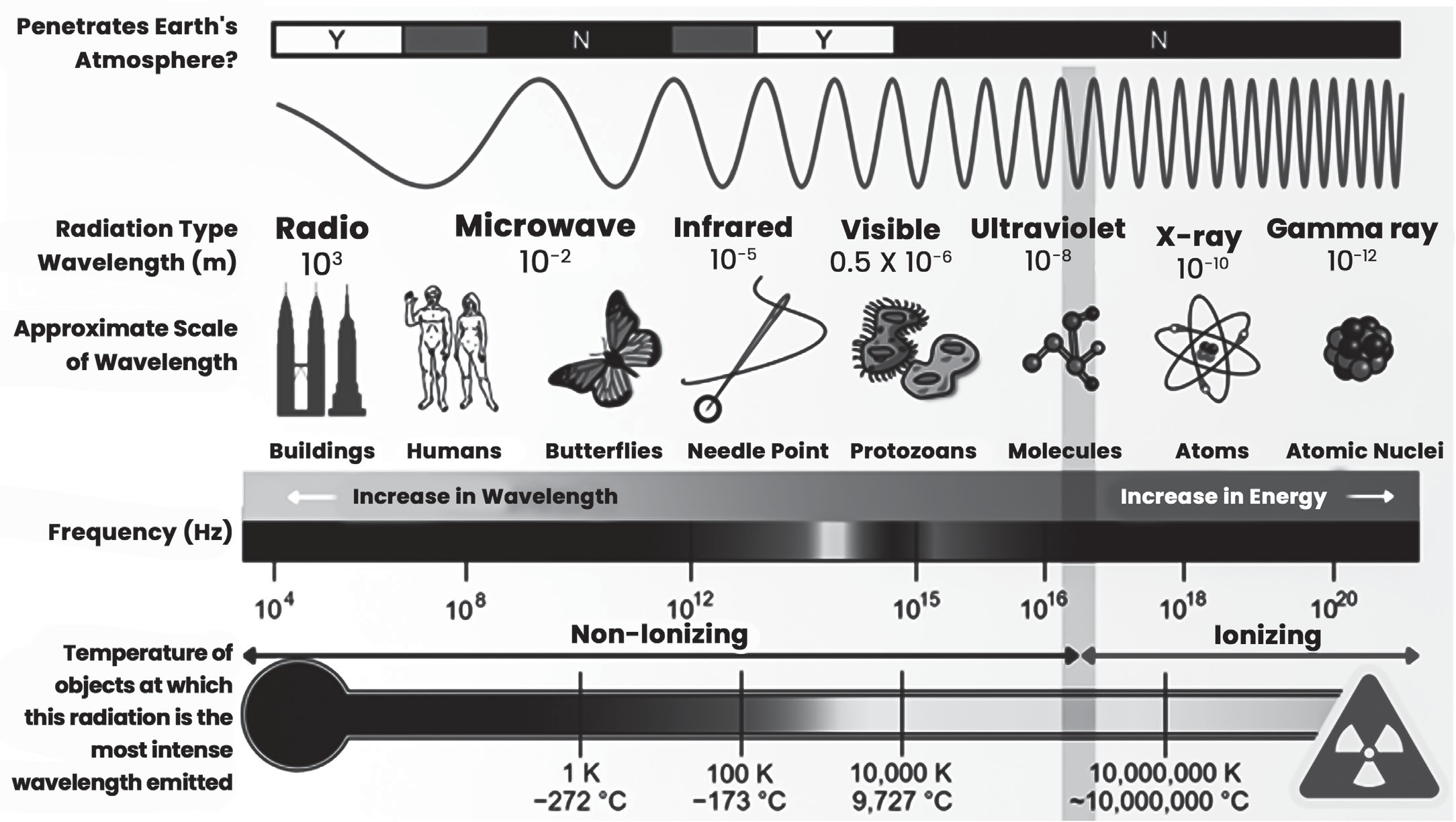
Ionising and Non-Ionising Radiation
Radioactivity occurs when certain elements undergo spontaneous decay, emitting particles such as alpha-particles (protons), beta-particles (electrons), and gamma rays (short- wave electromagnetic waves) from their atomic nuclei. These emissions are responsible for radioactive pollution.
Radiations can be divided into two main groups: non-ionising radiations and ionising radiations.
Non-Ionising Radiation
Non-ionising radiation consists of electromagnetic waves with longer wavelengths on the spectrum, ranging from ultraviolet (UV) to radio waves, which include microwaves.
These waves have sufficient energy to excite the atoms and molecules of the medium they pass through, causing them to vibrate faster. However, they lack the energy required to ionise atoms or molecules.
Non-ionising radiation can cause damage to the human body. For example:
UV radiation can harm the eyes, leading to conditions like snow blindness when reflected from surfaces like coastal sand or snow, or when directly staring at the sun during an eclipse.
Exposure to UV radiation can also injure skin cells and blood capillaries, resulting in blisters and reddening, known as sunburns.
In microwave ovens, non-ionising radiation causes water molecules in the food to vibrate faster, raising the temperature of the food as a result.
IMPACT OF NON-IONISING RADIATION FROM MOBILE PHONE TOWERS
Health Impact:
Non-ionising radiation emitted from mobile phone towers can have various health impacts:
Each antenna on a cell phone tower emits electromagnetic radiation (EMR).
When multiple operators use a single tower, the number of antennas increases, leading to higher power intensity in the surrounding area.
The power level of EMR near towers is higher and decreases as distance from the tower increases.
EMR can cause cellular and psychological changes in humans due to thermal effects caused by the absorption of microwave radiation.
Exposure to EMR may lead to genetic defects, reproductive and developmental issues, and affect the Central Nervous System.
Additionally, EMR can cause non-thermal effects, which occur at levels too low to produce significant heating and are related to the movement of ions across cell membranes.
Such exposure is associated with symptoms like fatigue, nausea, irritability, headaches, loss of appetite, and other psychological disorders.
Current exposure safety standards primarily focus on the thermal effects of radiation, with limited consideration for evidence of non-thermal effects.
Impact on Birds
Birds can be significantly impacted by non-ionising radiation from mobile phone towers:
Birds have a relatively larger surface area compared to their body weight, leading to greater absorption of radiation.
Due to their small body weight, birds have less fluid in their bodies, causing them to heat up more quickly when exposed to radiation.
The magnetic fields emitted by the towers can disrupt birds’ navigation abilities.
When exposed to electromagnetic radiation (EMR), birds may become disoriented and start flying in erratic patterns or in random directions.
Collisions with telecommunication masts are a significant cause of bird fatalities each year. This could be attributed to disorientation caused by EMR or other factors associated with the presence of the towers.
Ionising Radiation
Ionising radiation is highly damaging to living organisms because it causes ionisation, the process by which atoms or molecules gain or lose electrons, forming ions. This occurs when ionising radiation interacts with the atoms or molecules of the medium it passes through.
Examples of ionising radiation include:
Electromagnetic radiations such as short wavelength ultraviolet radiation (UV), X-rays, and gamma rays.
Energetic particles produced in nuclear processes, such as electrically charged alpha and beta particles from radioactive decay, and neutrons from nuclear fission.
These types of radiation have enough energy to knock electrons out of atoms or molecules, producing ions. These ions can induce reactions that break bonds in important molecules like proteins and DNA.
For instance, when a gamma ray passes through a cell, it may ionise water molecules near the DNA, leading to reactions that can damage the DNA.
Ionising radiation can also cause chemical changes by breaking chemical bonds, which can damage living tissues. Short-term effects may include burns, impaired metabolism, tissue death, and even death of organisms.
Long-term effects of ionising radiation exposure include mutations, increased incidence of tumors and cancer, shortened lifespan, and developmental changes.
In contrast to non-ionising radiation, which affects only components that absorb it and has low penetrability,
ionising radiation has high penetration power and can cause breakage of macromolecules, leading to significant biological damage.
Biological Damage Due to Ionising Radiation
Ionising radiation can cause significant biological damage, which can be categorised into two main types: somatic damage and genetic damage.
Somatic damage, also known as radiation sickness, refers to harm to cells that are not involved in reproduction.
The effects of somatic radiation damage include:
Loss of hair.
Fibrosis of the lungs.
Reduction of white blood cells, weakening the immune system.
Induction of cataracts in the eyes.
Increased risk of cancer development.
Ultimately, somatic damage can lead to death.
Genetic damage refers to harm to cells involved in reproduction, which can result in gene mutations and abnormalities. These genetic mutations can be passed on to future generations, leading to hereditary disorders or increased susceptibility to diseases.
Radiation Dose
Radiation dose is typically measured in the traditional unit called the rem, which stands for radiation equivalent in man.
At low doses, such as those received from background radiation on a daily basis (less than 1 mrem), cells can repair the damage quickly.
However, at higher doses, up to 100 rem, the cells may struggle to repair the damage, leading to potential consequences such as radiation sickness.
In cases where cells are unable to repair the damage or are permanently altered, they may produce abnormal cells during division. These abnormal cells can lead to the development of cancer.
The Damage Potential of Radiation Particles
The damage potential of radiation particles varies depending on their type:
Alpha particles: These particles can be stopped by a piece of paper or even human skin. However, if they enter the body, they can cause significant damage to internal tissues.
Beta particles: Beta particles can penetrate through the skin, but they can be stopped by materials like glass or metal. They have less penetrating power compared to gamma rays.
Gamma rays: Gamma rays have high penetrating power and can easily pass through human skin, damaging cells along their path. They can travel long distances and are only effectively blocked by dense materials such as thick concrete or lead.
Half-Life – Period of Radioactivity
Each radioactive substance has a consistent decay rate, meaning a predictable number of its atoms will decay over time.
The half-life of a radioactive material refers to the time required for half of its atoms to undergo decay.
Half-lives can vary widely, ranging from fractions of a second to thousands of years, depending on the specific radionuclide.
Radionuclides with longer half-lives are significant sources of environmental radioactive pollution because they remain active for extended periods, contributing to long-term radiation exposure risks.
Accidents at Nuclear Power Plants
Accidents at nuclear power plants can have catastrophic consequences due to the potential release of highly dangerous radioactive materials into the environment.
Nuclear fission within the reactor core generates a significant amount of heat. If this heat is not properly controlled, it can lead to a meltdown of the fuel rods, resulting in the release of large quantities of radioactive materials.
Meltdowns can occur accidentally and pose disastrous consequences for humans, animals, and plants due to exposure to radiation.
To prevent such accidents and reactor explosions, nuclear reactors are equipped with various safety features.
Despite these safety measures, notable disasters have occurred in nuclear power plants, including the Three Mile Island incident in 1979, the Chernobyl disaster in 1986, and the Fukushima Daiichi nuclear accident in 2011.
In the Three Mile Island and Chernobyl incidents, a series of mishaps and errors led to overheating of the reactor core and the release of radiation into the environment.
While the leakage from the Three Mile Island reactor was relatively low, resulting in no immediate injuries, the Chernobyl disaster resulted in heavy leakage, causing the deaths of many workers and widespread radiation contamination across Europe.
The Fukushima Daiichi nuclear accident, triggered by an earthquake, also resulted in significant radiation release and environmental contamination.
Safe Disposal of Nuclear Wastes
Radioactive wastes are broadly categorised into two types:
Low-level radioactive wastes (LLW): These include materials generated from various civilian applications of radionuclides in medicine, research, and industry.
Examples of LLW include:
Waste from medical procedures involving radioactive materials.
Materials from research activities using radioactive substances.
Waste from industrial processes utilising radioactive materials.
Clothing and protective gear worn by individuals working with radioactive materials or in nuclear facilities.
Materials from decommissioned nuclear reactors.
High-level radioactive wastes (HLW): These are the most hazardous forms of radioactive waste and typically result from:
Spent nuclear fuel rods from nuclear reactors.
Obsolete nuclear weapons or materials derived from their production.
HLW contains highly radioactive isotopes with long half- lives, making them extremely hazardous to human health and the environment.
Some Proposed Methods of Disposing Nuclear Waste
Deep underground burial in insulated containers: This involves burying the waste deep underground in specially designed containers to prevent leakage into the environment. This method is being pursued in the United States.
Space or sun disposal: This method involves launching the waste into space or directing it towards the sun. However, the high cost and the potential for catastrophic accidents during launch make this method impractical.
Burying under ice sheets: Proposed for burial under the ice sheets of Antarctica or Greenland, this method is prohibited by international law due to concerns about destabilising the ice and potential environmental impacts.
Deep ocean disposal: This involves dumping the waste into deep ocean trenches using glass and steel containers. However, there are concerns about container leakage and the contamination of ocean ecosystems.
Transformationintoharmlessisotopes:Whiletheoretically desirable, there is currently no known method to achieve this transformation, and any potential method would likely be prohibitively expensive.
Storage in special ponds or reprocessing: Currently, waste fuel rods are often stored in special storage ponds at reactor sites or sent to reprocessing plants. Reprocessing is more expensive but is used by some countries as an alternative to long-term waste storage.
Soil & Land Degradation
Land degradation refers to the temporary or permanent decline in the productivity of land due to various factors such as physical, chemical, or biological causes.
Soil degradation specifically refers to the deterioration in soil quality resulting from its improper use, typically in agricultural, pastoral, industrial, or urban activities.
It is a significant environmental issue globally and may worsen due to the effects of climate change.
Soil degradation can manifest in different forms, including physical erosion, chemical changes such as
salinity or pollution, and biological deterioration like loss of vegetal cover.
Deforestation
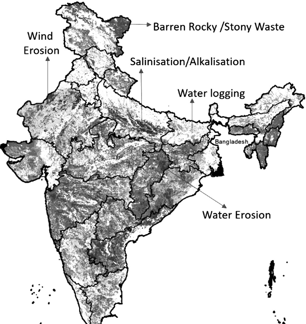
Deforestation is the process of clearing or removing trees and forests, often due to increasing human population and demand for land and resources. This practice puts significant pressure on forest ecosystems and can have several negative impacts, including soil erosion.
One major consequence of deforestation is soil erosion, which occurs when the roots of trees and plants, which help bind soil particles together, are removed. Without this natural protection, soil becomes more vulnerable to erosion by wind and water. This erosion can lead to the degradation of soil quality and fertility (affecting agricultural productivity and ecosystem health).
In regions like the Shiwalik range, the Chos of Punjab, and the ravines of the Chambal valley, deforestation has resulted in large-scale damage to soil due to increased erosion.
Major Causes of Deforestation
Deforestation, the widespread clearing of forests, is driven by various factors that contribute to the loss of tree cover and forest ecosystems:
Shifting Cultivation
This traditional agricultural practice involves clearing patches of land, burning vegetation, and using the ash to fertilise the soil for crop cultivation.
After a few years of cultivation, the land is abandoned to allow it to regenerate its fertility, while a new area is cleared for farming.
Population growth and increased demand for land have
made this practice unsustainable, leading to widespread deforestation in forested areas.
Development Projects and Mining
Large-scale infrastructure projects and mining operations often require clearing extensive forested areas.
Opencast mining, in particular, has been a significant driver of deforestation worldwide, leading to the loss of forest cover.
Plantation Boom
The rising demand for commodities such as cocoa, coffee, tea, sugar, palm oil, and rubber has led to the expansion of large- scale plantations in tropical rainforests. Forests are cleared to make way for these plantations, resulting in significant deforestation.
Raw Material Extraction
Forests are a source of various raw materials used in industries such as paper, plywood, furniture, and packaging.
Industries extract wood and other resources from forests.
Other Causes
Overgrazing by livestock, expansion of agricultural land, urbanisation, natural disasters like floods and fires, pest infestations, diseases affecting trees, as well as activities related to defence and communication, also contribute to deforestation.
Effects of Deforestation
The effects of deforestation are far-reaching and impact various aspects of the environment.
Deforestation leads to the loss of closed forests, resulting in an increase in degraded forests with diminished canopy cover.
Forests play a crucial role in the hydrological cycle by recycling moisture through transpiration, which then precipitates as rain.
Deforestation disrupts this cycle, leading to decreased transpiration and reduced precipitation, which can result in lower groundwater levels and altered rainfall patterns.
The removal of vegetation cover through deforestation increases the risk of soil erosion, as the roots of trees and plants no longer bind the soil together.
This erosion leads to land degradation, loss of soil fertility, and reduced agricultural productivity.
Deforestation can alter groundwater channels and recharge patterns, leading to changes in the availability of groundwater resources.
Reduced vegetation cover can also result in increased surface runoff and decreased infiltration, further exacerbating groundwater depletion.
Deforestation directly affects biodiversity by destroying habitats and disrupting ecosystems (loss of plant and animal species). It also fragments habitats, making it
difficult for species to migrate and adapt to changing environmental conditions.
Deforestation contributes to environmental pollution by releasing carbon dioxide into the atmosphere and reducing the capacity of forests to absorb pollutants.
It also exacerbates the scarcity of resources such as clean water, timber, and non-timber forest products.
Overgrazing
Overgrazing occurs when animals consume vegetation beyond the capacity of the land to regenerate, resulting in various detrimental effects.
During the rainy season, there is ample vegetation for grazing animals, providing them with sufficient fodder. However, during dry periods, vegetation becomes scarce, leading to a shortage of fodder for grazing animals.
In the absence of adequate fodder, animals graze grass to the ground and may even uproot plants.
Overgrazing disrupts the soil structure, making it more susceptible to erosion by rainwater. The constant trampling of hooves pulverises the soil, reducing it to fine particles, which further worsens soil erosion during heavy rainfall.
The loss of vegetation cover and disruption of soil structure due to overgrazing contribute to increased soil erosion. Without vegetation to anchor the soil, it becomes more prone to erosion by wind and water.
Overgrazing-induced soil erosion is particularly common in hilly areas, where the steep terrain exacerbates the effects of erosion.
Faulty Methods of Agriculture
Faulty agricultural practices contribute significantly to soil erosion in India, with several practices aggravating the problem.
Ploughing along the slope of the land facilitates the easy flow of water, leading to soil erosion. This method allows rainwater to wash away topsoil, particularly on sloping terrain.
Continuous cultivation of the same crop in the same field year after year depletes soil nutrients and disrupts the natural balance of soil chemistry. This practice makes the soil more susceptible to erosion by wind and water.
Shifting cultivation, a traditional agricultural practice, involves clearing patches of forest for cultivation and then abandoning them after a few years.
The removal of forest cover exposes the soil to the elements, making it vulnerable to erosion by rain and sun, especially on hilly slopes.
Growing the same crop repeatedly in the same area leads to soil exhaustion and reduces soil fertility. This makes the soil more prone to erosion by wind and water.
Deforestation associated with shifting cultivation or clearing land for agriculture exposes the soil to erosive forces.
The loss of vegetation cover removes the natural protection against soil erosion, resulting in the loss of topsoil, particularly on hillsides.
Soil Salinity and Soil Alkalinity
Soil salinity and alkalinity occur when the topsoil becomes saturated with salts and alkaline substances.
Saline and alkaline efflorescences, consisting of salts like sodium, magnesium, and calcium, develop in the topsoil due to the weathering of undecomposed rock fragments.
Some salts are carried in solution by rivers and can be deposited in soil through irrigation water.
In regions with inadequate drainage, stagnant water with high salt concentration evapourates, leaving behind salt deposits in the topsoil.
In areas with high groundwater tables, harmful salts are drawn up to the surface through capillary action during dry seasons.
Over-irrigation in canal-irrigated regions can lead to rising groundwater levels, bringing salts to the surface through capillary action.
Regions facing soil salinity and alkalinity issues include canal-irrigated areas in Uttar Pradesh, Punjab, and Haryana, as well as arid and semi-arid regions of Rajasthan, Maharashtra, Gujarat, Andhra Pradesh, Telangana, and Karnataka.
Impact of Large-Scale Irrigation Projects
While large-scale irrigation projects like the Indira Gandhi Canal in Rajasthan have transformed arid lands into productive agricultural areas, they have also contributed to soil salinity and alkalinity problems due to over-irrigation.
Addressing soil salinity and alkalinity requires implementing proper irrigation and drainage practices, promoting soil conservation techniques, and adopting crop varieties tolerant to saline and alkaline conditions.
Additionally, measures to improve water management and reduce over-irrigation are essential for sustainable soil and agricultural management in affected regions.
Steps to Treat Salinity and Alkalinity
Treating soil salinity and alkalinity requires a combination of management practices and soil amendments to improve soil quality and fertility.
Establishing proper drainage systems to remove excess water from the soil and lower the water table, preventing the buildup of salts.
Repairing leakages in canals, tanks, and other water bodies to prevent the infiltration of saline water into the soil.
Adopting water-efficient irrigation methods such as drip irrigation or sprinkler systems to minimise waterlogging and salt accumulation in the soil.
Planting salt-tolerant vegetation or cover crops to
improve soil structure, reduce erosion, and absorb excess salts from the soil.
Implementing crop rotation practices to break the cycle of salt accumulation and improve soil health over time.
Applying gypsum (calcium sulphate) to the soil to displace sodium ions and improve soil structure, promoting better water infiltration and reducing soil alkalinity.
Using acidifying agents such as sulphuric acid, sulphur, or organic residues like rice husks to lower soil pH and neutralise alkaline compounds.
Desertification
Desertification refers to the expansion of desert-like conditions in arid or semi-arid regions, primarily due to human activities or changes in climate patterns.
Uncontrolled grazing, where excessive livestock consume vegetation, leading to soil erosion and degradation.
Deforestation, especially the indiscriminate cutting down of trees, disrupts ecosystems and exposes soil to erosion by wind and water.
Growing population puts pressure on land resources, leading to unsustainable land use practices that contribute to desertification.
Changes in climate patterns, such as prolonged droughts or shifts in precipitation patterns, exacerbate arid conditions and contribute to the spread of deserts.
Wind erosion is a significant factor in desertification, as sand and dust carried by wind are deposited on fertile lands, reducing soil fertility and productivity.
Soil erosion leads to the loss of topsoil, which is rich in nutrients necessary for plant growth, further degrading land quality.
The Thar Desert in India is expanding rapidly, advancing at a rate of approximately 0.5 km per year, primarily due to desertification processes.
Ecological Implications of Desertification
The ecological implications of desertification are significant and can have far-reaching consequences:
Drifting sand and its accumulation on fertile agricultural land lead to soil degradation (reduction in fertility and productivity).
Excessive soil erosion by wind and, to a lesser extent, by water, further exacerbates land degradation and loss of topsoil.
Deposition of sand in rivers and lakes reduces their water-holding capacity, leading to decreased availability of water resources.
Lowering of the water table due to reduced infiltration and increased evapouration rates contributes to acute water shortages, impacting both human communities and ecosystems.
Desertification results in the expansion of wastelands, areas where land is no longer suitable for agriculture
or habitation due to degradation and loss of vegetation cover.
Decreased agricultural production due to soil degradation and water scarcity reduces food availability and can lead to food insecurity in affected regions.
Desertification can increase the frequency and intensity of droughts.
Measures of Controlling Desertification
Controlling desertification requires a combination of proactive measures aimed at conserving soil and vegetation, as well as sustainable land management practices.
Planting trees in transition zones and other vulnerable areas helps stabilise the soil, prevent erosion, and create microclimates conducive to vegetation growth.
Applying mulch to shifting sand dunes can help stabilise them and prevent further movement. Different plant species can be used for mulching to provide effective physical barriers against sand movement.
Implementing controlled grazing practices helps prevent overgrazing, which can worsen soil erosion and land degradation. Developing new pastures and rotational grazing systems can also reduce pressure on existing vegetation.
Banning indiscriminate felling of trees and promoting sustainable forestry practices such as selective logging and reforestation efforts help conserve forest resources and maintain ecosystem integrity.
Encouraging the use of alternative sources of fuel, such as biogas, solar energy, and improved cookstoves, reduces the demand for fuelwood and alleviates pressure on forests.
Proper land use planning ensures that sandy and wasteland areas are utilised judiciously. This may involve reclamation projects, afforestation initiatives, and sustainable agricultural practices tailored to local conditions.
Waterlogging
Waterlogging occurs when the land becomes saturated with water, leading to detrimental effects on soil and vegetation. Flat terrain and depressions in the landscape contribute to the accumulation of water.
Excessive rainfall or leakage from water sources can lead to waterlogging.
In India, approximately 12 million hectares of land are affected by waterlogging, with coastal and inland areas equally affected.
Waterlogging is a significant contributor to soil salinity, further degrading soil quality and fertility. It inhibits root growth and oxygen exchange.
Mitigation Measures
Proper drainage schemes are essential to address waterlogging issues effectively.
Surface drainage involves the construction of open drainage systems to divert excess water away from the land.
Vertical drainage methods, such as bore-wells, are used to extract underlying water and alleviate waterlogging, particularly in regions like the Indo-Gangetic Plain.
Characteristics of Indian Soils
Indian soils vary in age, with soils in the peninsular plateau being older than those in the northern plains. Most soils are mature, having undergone extensive weathering and soil formation processes over time.
Indian soils are often deficient in essential nutrients like nitrogen, mineral salts, and organic materials.
This deficiency can affect crop growth and yield unless supplemented through fertilisation.
Plains and valleys typically have deep soil layers, conducive to agriculture.
In contrast, hilly and plateau areas have thinner soil cover.
Some Indian soils, such as alluvial and black soils, are naturally fertile and support high agricultural productivity.
However, soils like laterite, desert, and alkaline soils are less fertile and may require extensive soil management practices to enhance productivity.
Indian soils have been cultivated for centuries, leading to the depletion of fertility over time.
Continuous agricultural practices without adequate soil conservation measures have contributed to soil degradation and loss of productivity.
Water Erosion
Water erosion takes place when soil particles are carried away by running water. This can occur due to raindrops, waves, or melting ice.
There are different types of water erosion, including raindrop erosion (caused by raindrops), sheet erosion (when water flows evenly over a surface), rill and gully erosion (creating small channels or larger gullies in the soil), stream bank erosion (along riverbanks), landslides, coastal erosion (at coastlines), and glacial erosion (caused by glaciers).
Raindrop Erosion or Splash Erosion
A raindrop, which is about 5 millimeters wide, falls onto the ground at a speed of about 32 kilometers per hour. Sometimes, bigger raindrops and strong gusts of wind can hit the soil even faster.
Raindrop erosion, also known as splash erosion, occurs when raindrops hit the soil surface. These raindrops act like tiny bombs, displacing soil particles and breaking down soil structure.
Vegetation helps prevent raindrops from directly hitting the soil, reducing erosion in areas covered by plants.
Sheet Erosion
When it rains continuously, the soil particles that are displaced start filling in the gaps between other soil particles. This makes it difficult for water to soak into the soil, leading to water flowing over the surface and causing even more erosion. This process of soil particles being detached and carried away by flowing rainwater is called sheet erosion.
Over time, weathering and erosion smooth out the uneven surfaces of landforms, creating a flat area known as a peneplane.
Rill and Gully Erosion
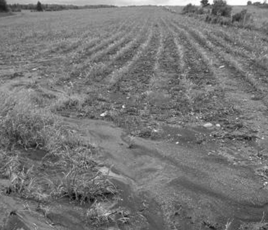
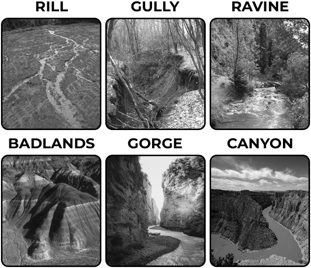
In rill erosion, small channels resembling fingers appear on cultivated land after sheet erosion. These channels, called rills, are smoothed out each year but gradually become wider and deeper over time.
Gully erosion occurs when soil is removed along drainage lines by runoff water. As rills grow larger, they turn into gullies. Gullies continue to expand due to erosion along their edges or by the collapse of their walls.
Extensive gully formation leads to badland topography, like the Chambal Ravines. When gullies deepen and flatten, they become ravines, which can be over 30 meters deep.
Further erosion can create canyons, which are even deeper and wider, like the Grand Canyon.
Streambank Erosion
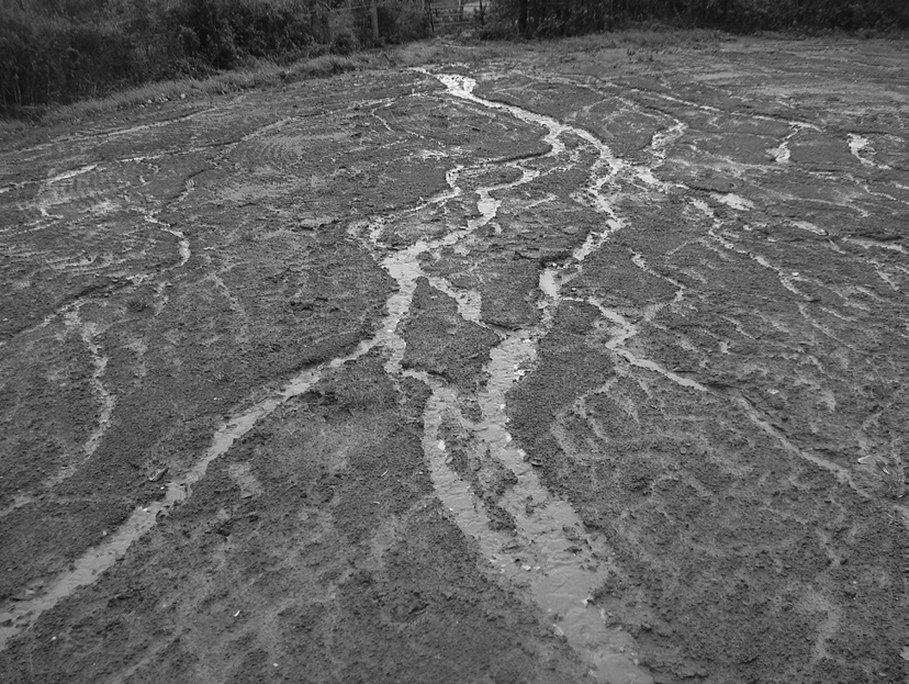
Streambank erosion occurs when soil is washed away from the shores of streams or rivers by the flowing water.
This erosion can occur more quickly in areas where the river’s path changes.
It can harm nearby farmland, roads, and bridges.
Landslide
A landslide is when a large amount of soil suddenly moves downhill. It occurs because the soil becomes unstable and loses its balance, often due to too much water.
Gravity then pulls the soil and rocks downhill quickly.
Coastal Erosion
Coastal erosion is when waves crash against the shoreline, wearing away the soil. During cyclones or storms, strong waves can damage beaches and remove the top layer of soil.
In estuaries, tidal bores can also harm the nearby banks.
Glacial Erosion
Glacial erosion happens in icy places like polar regions and high mountains such as the Himalayas. It occurs when glaciers slowly move, scraping and carrying away soil and rocks as they slide along.
Groyne for Coastal Protection
In Mamallapuram, Tamil Nadu, the shoreline near the Shore Temple is experiencing severe erosion from the sea.
The Public Works Department plans to build groynes for coastal protection.
About 4-5 meters of shoreline near the temple erodes annually.
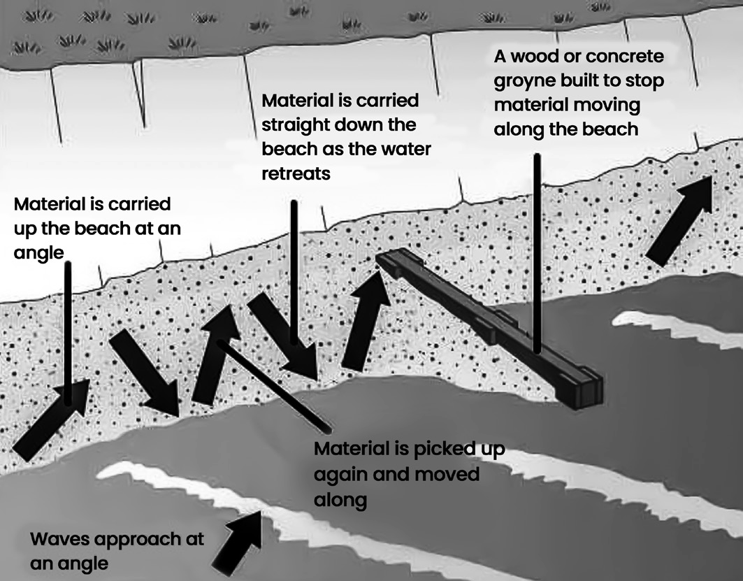
A groyne is a structure built perpendicular to the coast or river shoreline, designed to reduce erosion by blocking the movement of sand along the shore.
Typically made of rock or other materials like wood or concrete, groynes act as barriers to trap sediment and absorb wave energy, helping to stabilise the shoreline.
Wind Erosion
Wind erosion occurs when soil is carried away by the wind, usually in areas where vegetation has been removed. This often occurs in dry or arid regions, like sandy shores near bodies of water.
There are three main ways soil particles are moved by the wind:
Siltation: Soil particles are bounced along the ground by the wind in short hops.
Suspension: Soil particles are lifted and carried through the air over long distances.
Surface creep: Soil particles are pushed along the ground by strong winds.
Consequences of Wind Erosion
Wind erosion takes away the finer soil particles, like organic matter and clay, leaving behind less fertile soil.
This loss of soil nutrients affects the soil’s ability to support plant growth.
Additionally, wind-blown soil can damage roads and agricultural fields by depositing layers of soil on them.
Soil Conservation
Soil conservation means taking steps to protect soil from erosion or becoming less fertile due to various factors like overuse, acidification, or contamination. It’s crucial for maintaining agriculture and animal husbandry. To put it simply, it’s like safeguarding the source of our prosperity.
Crop Rotation
Crop rotation means planting different crops in a specific order on the same plot of land over successive seasons or years.
This helps maintain soil fertility and prevent depletion of nutrients because different crops have different nutrient needs.
For instance, one year you might plant potatoes, which require a lot of potassium, and the next year, you might plant wheat, which requires more nitrogen.
Also, certain crops, like legumes, can even help replenish soil nutrients by fixing nitrogen from the air into the soil.
Therefore, crop rotation is an essential practice for sustainable agriculture and soil conservation.
Strip Cropping
Strip cropping is a farming technique where different crops are grown in alternating strips or rows across a field. This method helps prevent soil erosion and improves water retention.
By alternating crops and leaving some strips fallow, soil nutrients are better preserved, and the risk of soil erosion is reduced.
Also, tall crops grown in some strips act as natural windbreaks, further protecting the soil from erosion caused by wind.
Strip cropping also helps to slow down water runoff, allowing more water to be absorbed by the soil and reducing the risk of flooding and soil erosion.
Use of Early Maturing Varieties
Using early maturing varieties of crops means choosing plants that reach maturity and can be harvested in a shorter amount of time.
By planting these varieties, farmers reduce the time crops spend on the field, which can help lessen the strain on the soil.
This reduces the risk of soil erosion because the soil is not exposed to erosion-causing factors for as long. In short, early maturing crops can help protect the soil by minimising the time it is vulnerable to erosion.
Contour Ploughing
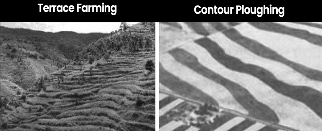
Contour ploughing is when farmers plough their fields following the natural curves or contours of the land, instead of ploughing straight up or down a slope. By ploughing along the contour lines, ridges and furrows are created that help slow down the flow of water.
This reduces the risk of soil erosion because the water is less likely to wash away the soil.
It also helps to retain more water in the soil for the plants to use. In essence, contour ploughing helps to conserve soil and water by working with the natural shape of the land.
Checking Shifting Cultivation
To control shifting cultivation, efforts should be made to encourage tribal communities to adopt settled agriculture instead.
This could involve resettling them in permanent locations and providing them with housing, farming tools, seeds, fertilisers, livestock, and cultivated land that has been restored.
Ploughing the Land in Right Direction
Ploughing the land across the direction of the wind slows down the wind speed, which helps protect the topsoil from being blown away.
Mulching
Mulching involves covering the bare soil between plants with materials like grass clippings or straw.
This layer offers several benefits, it protects the soil from erosion, retains moisture, reduces compaction from heavy rains, conserves water, maintains soil temperature, prevents weed growth, and improves soil condition as it decomposes over time, adding organic matter.
Contour Barriers
Contour barriers are structures made from stones, grass, or soil along the contours of slopes.
Trenches are dug in front of these barriers to collect water. They work by intercepting water and soil flowing downhill, slowing down the water’s speed and reducing erosion. Also, they filter out and trap soil particles, preventing them from being washed away.
Over time, soil accumulates behind these barriers, creating terraces. Contour barriers can be made from live plants, dead materials like rocks or crop residues, or a combination of both.
Rock Dam
A rock dam is created by piling rocks across a channel. This slows down the flow of water, preventing gullies and further loss of soil.
Terrace Farming
Terrace farming involves cutting a series of flat platforms or terraces into a steep slope. This creates flat areas where crops can be grown. Terrace farming helps reduce surface runoff and soil erosion on steep slopes.
Contour Bunding
Contour bunding is the construction of banks along the contour lines of a hill slope.
This helps to slow down the flow of water and promote the absorption of water by the soil.
It also prevents soil erosion by controlling the movement of water along the slope.
Intercropping
Intercropping is when different crops are grown in alternating rows and planted at different times. This helps to protect the soil from being washed away by rain.
Contour Ploughing
Contour ploughing means ploughing the land along the natural contours or curves of a hillside. This helps to create ridges and furrows that act as barriers, slowing down the flow of water and preventing soil erosion downhill.
Shelterbelts or Windbreaks
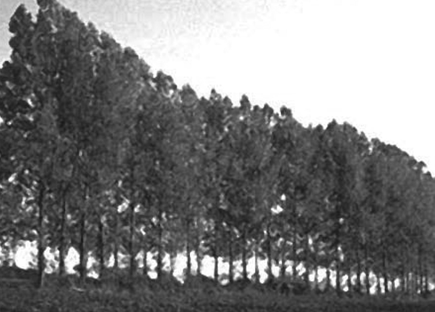
Shelterbelts or windbreaks are rows of trees planted in coastal and dry areas to block or reduce the force of wind, helping to protect the soil from erosion.
Sand Fences
Sand fences are structures made of small wooden slats or fabric that are placed to slow down the wind and catch blowing sand. They are often used around construction sites to prevent soil and sand from being carried away by the wind.

Afforestation
Afforestation involves protecting existing forests from destruction and planting new trees to increase forested areas. The goal is to maintain a healthy balance of forest cover for soil and water conservation.
Initially, it was recommended that 20 to 25 percent of the land be forested, but this was later increased to 33 percent, with specific targets for different types of terrain.
Checking Overgrazing
To prevent soil erosion, it’s important to address overgrazing, which worsens during dry periods when there’s a shortage of fodder. Animals graze the grass down to the ground, damaging the soil with their hoofs.
To tackle this, we need to create designated grazing areas and produce more fodder.
Dams
Constructing dams at strategic locations can help prevent soil erosion caused by river floods by regulating water flow.
However, haphazard dam construction can worsen issues such as floods and landslides, particularly in vulnerable regions like the Himalayas.
Addressing Land Degradation and Desertification
SDG 15 aims to ensure the protection, restoration, and sustainable use of terrestrial ecosystems, including forests, and to combat desertification, land degradation, and biodiversity loss.
The recent decades have seen desertification accelerate at a rate 30 to 35 times faster than historical levels.
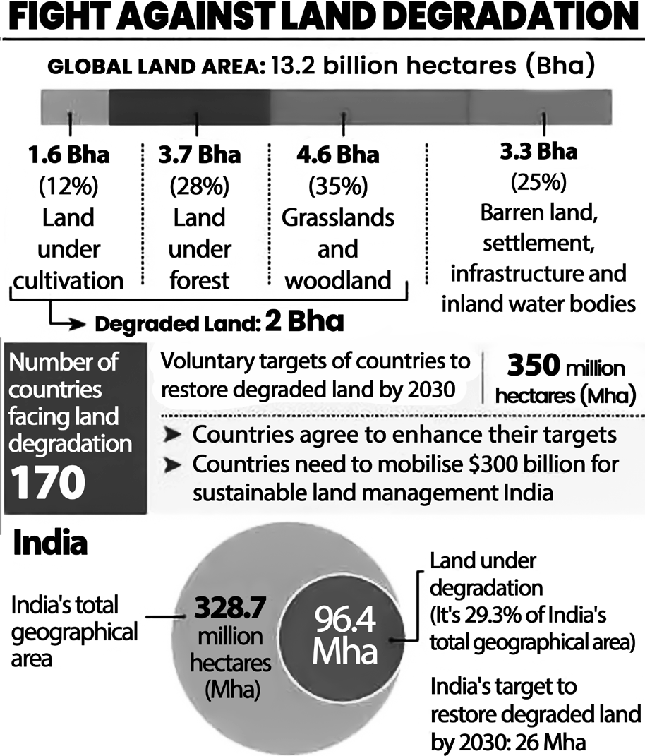
Alarmingly, approximately one-quarter of the world’s land has degraded over the past two decades.
This degradation directly impacts the lives of around 1.5 billion people who rely on these deteriorating lands for their livelihoods.
United Nations Convention to Combat Desertification (UNCCD)
The United Nations Convention to Combat Desertification (UNCCD) was established in 1994 as a result of the Rio de Janeiro Earth Summit, alongside other key environmental agreements.
It is the only legally binding international treaty that addresses the issues of land degradation and desertification.
Ratified by 196 countries and the European Union, including India in 1996, the UNCCD aims to promote global action for sustainable land management.
It emphasises the development of national action programs (NAPs) that involve local communities in efforts to restore degraded lands.
Also, the convention established the Global Mechanism (GM) to help countries mobilise financial resources for implementing its objectives.
Land Degradation Neutrality (LDN) Initiative
LDN, or Land Degradation Neutrality, was introduced following the UN Conference on Sustainable Development (RIO+20) in 2012.
In 2015, LDN became a target for Sustainable Development Goal (SDG) 15, which focuses on preserving life on land.
At COP12 to UNCCD, countries adopted LDN as a key tool for implementing UNCCD and urged nations to set voluntary targets to achieve “no net loss” by 2030.
The New Delhi Declaration saw over 190 countries committing to achieving land degradation neutrality by 2030, while ensuring that land rights of forest dwellers and women are protected.
However, achieving LDN requires a substantial investment of $300 billion for ramping up restoration efforts.
The LDN initiative is expected to bring various benefits, including mitigating and adapting to climate change, reducing hunger, ensuring access to clean water, and creating employment opportunities.
India’s LND Targets
India aims to revive 26 million hectares of deteriorated land by 2030, surpassing its previous goal of 21 million hectares.
UNCCD CoP-14 in New Delhi
The CoP is the highest decision-making body of UNCCD and meets every two years to review the Convention’s implementation and formulate strategies.
New Delhi hosted the 14th session of the Conference of Parties (CoP-14) from September 2 to 13, 2019.
India has hosted the COP of all three Rio conventions, making it among the few countries to do so.
At CoP14, India was elected president for the next two years.
The event gathered representatives from over 197 countries, NGOs, etc., to address issues related to combating desertification, land degradation, and drought.
The theme of COP14 was “Restore land, sustain future,” highlighting the importance of preserving land resources to prevent food insecurity, poverty, migration, and political instability.
UNCCD CoP 14: Only 25% of Nations Include Gender Discussions in Land Degradation Targets
UNCCD CoP 14: Only 25% of nations include gender discussions in land degradation targets:
UNCCD recognised that land degradation affects men and women differently in many developing countries due to unequal access to resources.
In 2017, UNCCD introduced a Gender Action Plan (GAP) for the first time in China.
Gender mainstreaming, or integrating gender considerations, brings additional benefits such as promoting gender equality, enhancing women’s access to resources, reducing poverty, and restoring ecosystems.
UNCCD mandates gender mainstreaming to support countries in achieving their Land Degradation Neutrality (LDN) targets.
However, only about 20 out of 80 countries have included discussions on the role of gender and women in their targets to halt land degradation by 2030.
UNCCD CoP 14: Report on Soil Organic Carbon
The report is titled “Realising the Carbon Benefits of Sustainable Land Management Practices.”
Soil Organic Carbon (SOC) plays a crucial role in providing various benefits.
It helps combat droughts, reduces soil diseases and compaction, and supports organic production.
Due to its multiple functions and sensitivity to land management, SOC is one of the three global indicators of Land Degradation Neutrality (LDN).
UNCCD GLOBAL LAND OUTLOOK REPORT
Loss of Cropland due to Urbanisation
Human settlements historically developed in fertile areas and accessible lands. The increasing size of urban areas is displacing significant amounts of fertile agricultural land.
Urbanisation is expected to lead to the loss of between
1.6 and 3.3 million hectares of prime agricultural land annually from 2000 to 2030 (48 to 99 million hectares in total).
The loss of croplands results in a 6% decrease in production in Asia and a 9% decrease in Africa.
Biodiversity Loss
Biodiversity loss due to urbanisation in Western Ghats and Sri Lanka hotspots could increase by about 900% by 2030 compared to the levels in 2000.
Increasing meat consumption worldwide has placed significant pressure on land resources.
If the average meat consumption per person per day is reduced from 100 grams to 90 grams, it could have a notable positive impact on human health and help mitigate climate change.
The rising demand for meat and other land-intensive foods, such as processed foods made with soy and palm, has contributed to crises like land scarcity and food insecurity.
Water Scarcity
Water scarcity is becoming a pressing issue globally.
By 2030, the demand for water is expected to exceed the capacity to extract it by 40%.
By 2050, up to one billion urban residents could face water shortages.
Nearly two-thirds of the world’s population may be living in water-stressed countries by 2025.
Agricultural water demand is set to double by 2050 due to increased food needs.
Salinity has affected 20% of irrigated land, leading to crop yield reductions. Some of the most water-intensive crops include cotton, rice, sugar cane, soy, and wheat.
Currently, two billion people and 40% of irrigation rely on groundwater, with countries like India, China, and the United States being heavy users.
Drought
Drought is a severe shortage of water that affects land and agriculture.
The UNCCD focuses on addressing drought as one of its key goals from 2018 to 2030.
They advocate for ‘drought-smart land management’ (D-SLM), which involves sustainable land management practices specifically aimed at combating drought and its impacts.
Cost
Investing $1.8 trillion in climate adaptation efforts over the next ten years could lead to significant changes.
Focusing on areas like early warning systems, resilient infrastructure, better dryland agriculture, and protecting mangroves could yield a return of $7.1 trillion, four times the initial investment.
Land for Energy Sources
The report highlighted that both fossil and renewable energy sources require land for extraction.
Biomass is particularly land-intensive, and solar power generation, especially Concentrated Solar Power System
(CSP), requires a significant amount of land compared to other green energy sources.
For instance, CSP consumes 15 square meters for every megawatt hour, whereas coal only needs five.
Desertification Setting in Across a Quarter of India
Desertification is affecting about a quarter of India’s land, with approximately 96.40 million hectares, or 30% of the country’s total area, undergoing degradation.
Drylands cover 228.3 million hectares, or 70% of India’s land, with 82.6 million hectares, or 25% of the total land area, experiencing desertification.
According to TERI’s estimate, this land degradation costs the country’s economy $48.8 billion annually, which is roughly 2.08% of India’s GDP in 2014-15.
Regional Causes Behind Desertification and Degradation
In Maharashtra, illegal logging by the timber mafia is destroying forests, causing soil erosion.
In Jharkhand and Odisha, excessive mining is leading to soil erosion and worsening water scarcity.
Goa is facing issues due to widespread mining and urban expansion.
In Nagaland, shifting cultivation practices and population growth are contributing to desertification.
Andhra Pradesh, Telangana, and Hyderabad Karnataka are experiencing droughts and increased reliance on borewells, leading to soil dryness.
Himachal Pradesh is affected by reduced snowfall and increased rainfall, exacerbating desertification.
In Gujarat, overgrazing and the conversion of grasslands for agriculture are causing degradation.
The Case of Goa Deforestation due to Illegal Mining
Illegal mining in Goa has caused significant deforestation and degradation.
The rush to export iron ore during China’s 2008 Olympics construction boom led to the destruction of large forested areas.
The Supreme Court intervened in 2012 to halt mining operations in Goa due to widespread illegal practices.
Soil Degradation due to Leaching of Harmful Chemicals Soil degradation occurs around mines due to the leaching of harmful chemicals.
When it rains, the soil in the mining area turns red with lateritic soil. To extract a tonne of ore, about 2.5 to 3 tonnes of overburden must be removed.
This overburden is often dumped outside the mining area onto agricultural land, where harmful chemicals leach out into the soil.
Apathy in Environmental Governance
The state of environmental governance in Goa reflects widespread neglect and discrepancies.
Despite Goa’s significant forest cover, much of it lies outside officially recorded forest areas.
For instance, while the government acknowledges only 1,224.46 sq km as government forest, the actual forest cover is much higher, at 2,229 sq km.
An example of this neglect is the proposed construction of an airport in Mopa.
Initially, the Environmental Impact Assessment (EIA) for the airport claimed no tree cover in the area. However, during a court case, the forest department suddenly discovered 54,676 trees in the same area.
Desertification in Cold Areas
Desertification isn’t just limited to hot, arid areas. It also affects cold regions known as cold deserts.
In India, around 80% of the cold desert area is in Ladakh, with the remaining in Himachal Pradesh and Uttarakhand.
In these regions, signs of desertification are visible, like shifting tree lines, moving sand dunes, and changes in soil moisture levels.
India lost 31% of Grasslands and 19% of Common Lands in a Decade
Over a decade, India experienced a significant decline in grasslands and common lands.
Grasslands, which covered 18 million hectares, shrank by 31%, down to 12.3 million hectares by 2015.
Particularly, the grasslands in the Aravalli range in Rajasthan faced severe degradation.
Also, common lands, which include grazing areas, forests, ponds, and rivers accessible to rural communities, decreased by 19%, from 90.5 million hectares to 73.02 million hectares.
State of India’s Environment (SoE) Report 2019
The State of India’s Environment (SoE) Report 2019 highlighted concerning trends regarding desertification and land degradation.
Between 2003-05 and 2011-13, desertification increased in 26 out of 29 states in India.
Despite committing to achieve land degradation neutrality by 2030, the country saw a rise of 1.87 million hectares undergoing desertification during this period.
Over 80% of the degraded land is concentrated in nine states: Rajasthan, Maharashtra, Gujarat, Jammu and Kashmir, Karnataka, Jharkhand, Odisha, Madhya Pradesh, and Telangana.
The districts most affected by desertification or land degradation include Jaisalmer, Lahaul and Spiti, and Kargil.
Addressing Land Degradation in India Bonn Challenge
The Bonn Challenge, launched in 2011, aims to restore 150
million hectares of the world’s deforested and degraded land by 2020.
In 2014, this target was extended to 350 million hectares by 2030 under the New York Declaration on Forests.
India joined the Bonn Challenge pledge voluntarily, committing to restore 13 million hectares of degraded and deforested land by 2020, with an additional 8 million hectares by 2030.
1/3rd of India must come Under forest Cover to Meet Bonn Challenge, Paris Agreement
To meet the targets set by the Paris Agreement and the Bonn Challenge, India needs to increase its forest cover significantly. Currently, about one-fourth of the country’s land is under forest cover.
To meet the targets, an additional 25-30 million hectares of land need to be brought under forest and tree cover, which means approximately one-third of India’s total land area should be covered by forests.
However, at the current rate of afforestation, India can only sequester a small amount of carbon dioxide (only 35 million tonnes of CO2), which is much lower than its commitment under the Paris Agreement.
Compensatory Afforestation Fund (CAF) Act, 2017
The Compensatory Afforestation Fund (CAF) Act, 2017 allows for compensatory afforestation to offset the loss of forests due to non-forest projects like industries and infrastructure.
Previously, afforestation was permitted only on degraded forest land if revenue land was unavailable.
In such cases, the degraded land needed to be twice the size of the forestland diverted. However, a recent notification under CAF now permits compensatory afforestation on forestland with crown density below 40 percent.
Challenges
The Forest Survey of India identifies forests with crown density ranging from 40 to 10 percent as “open forest”, which constitutes the second-largest forest category in the country, covering over 30 million hectares. This area accounts for 9.18 percent of India’s landmass or 42 percent of the total forest cover.
However, opening up such a vast area for plantation projects raises concerns about conflicts over land tenure.
India has approximately 300 million people who traditionally reside in and around forests, and their rights over forest land are recognised under the Forest Rights Act (FRA). Each individual is entitled to at least 4 hectares of land under this act.
Increasing tree Cover Outside Forest Areas
Increasing tree cover outside forest areas involves focusing on reclaiming wasteland, fallow land, and other degraded lands for afforestation activities. The Ministry
of Environment, Forest and Climate Change (MoEFCC) released a strategy in 2018 to guide this effort.
India has around 10 million hectares of culturable wasteland that can be targeted for afforestation.
The MoEFCC aims to incentivise individuals and institutions to undertake afforestation projects by providing monetary incentives and implementing flexible rules.
However, There are Challenges
Areas with inadequate rainfall, typically less than 50-60 cm annually, may not sustain tree growth effectively.
Many regions experiencing desertification, like those in Africa’s Sahel region, have attempted initiatives like the Great Green Wall (GGW) to combat desert expansion.
The GGW faced difficulties because plants couldn’t survive without sufficient water, highlighting the importance of water availability for successful afforestation efforts.
Agroforestry and Community Engagement could be a Viable Option
Agroforestry, along with active community involvement, presents a promising solution.
In Niger, smallholder farmers have actively safeguarded and nurtured naturally regenerating woody species on their farms. This approach has resulted in the establishment of new agroforestry parklands covering 5 million hectares.
In China, where a quarter of the land is desertified, successful community engagement has been crucial. Communities have played a significant role in China’s efforts to combat desertification (making it a global leader in greening deserts).
Desertification from a Conservation Perspective
Desertification, from a conservation standpoint, refers to the deterioration of land in arid, semi-arid, and dry sub-humid regions, rather than the natural expansion of existing deserts.
It entails the gradual decline in soil productivity, rendering the cultivation of food grains and other crops unviable.
In drylands, land degradation often leads to desertification, characterised by desert-like conditions.
This process is primarily driven by factors such as over- exploitation, recurrent droughts, and other climatic influences.
Importance of Reversing Land Degradation
Reversing land degradation in drylands is crucial for several reasons:
Extent of Dry lands: Drylands cover approximately 34% of the Earth’s land surface and contain half of the world’s farmlands.
Human Dependence: More than 2 billion people, as well
as half of the world’s livestock, rely on these drylands for their livelihoods and sustenance.
Given their significance in supporting both human populations and ecosystems, restoring degraded drylands is essential for ensuring food security, maintaining biodiversity, and safeguarding the well-being of millions of people and animals.
Effects of Land Degradation on People
Loss of Habitability: Degraded land loses its vegetative cover, rendering it unsuitable for human and animal habitation.
Forced Migration: Land degradation often leads to forced migration as people are compelled to leave degraded areas in search of better living conditions. This can result in socio-cultural and religious conflicts over land and water resources.
Urbanisation Pressure: In many cases, the loss of land productivity drives people from rural villages to urban centers in search of livelihood opportunities, leading to increased Urbanisation.
Brain Drain: Forced migration can also result in a loss of skilled individuals from rural areas, contributing to a “brain drain” phenomenon that deprives the country of origin of valuable human capital.
Strain on Resources: Host countries receiving migrants may face challenges in accommodating and providing for the needs of these individuals, putting a strain on their resources and social structures.
Land, Oceans, Forests
Land and oceans play critical roles in the carbon cycle, acting both as sources and sinks of carbon.
Carbon Absorption: Together, land and oceans absorb approximately 50 percent of greenhouse gases (GHGs) emitted annually through natural processes in the carbon cycle.
Importance of Afforestation: Afforestation, along with reducing deforestation, is crucial for combating climate change because it helps in sequestering carbon dioxide from the atmosphere.
India’s Action Plan: India’s action plan on climate change includes a significant focus on forests. The country has committed to creating an additional carbon sink of 2.5 to 3 billion tonnes by 2032 through measures such as increasing forest cover and planting more trees.
Glasgow Leader’s Declaration on Forests & Land Use
During the COP26 climate negotiations in Glasgow, a declaration on Forests & Land Use was adopted by over 100 countries. This ambitious declaration, spearheaded by the United Kingdom, aims to halt deforestation and land degradation by 2030.
Within the plan, global leaders recognised the crucial role of forests in balancing greenhouse gas emissions and removals, adapting to climate change impacts, and preserving healthy ecosystem services.
With more than 105 signatories, including major nations like the UK, US, Russia, and China, the declaration sets forth significant goals for global forest conservation.
However, notable absences among the signatories include India, Argentina, Mexico, Saudi Arabia, and South Africa, the only G20 countries that did not join the declaration.
Why India didn’t sign the Declaration?
India abstained from signing the declaration for several reasons.
Firstly, the declaration was perceived to interlink trade with climate change and forest issues, which India believed should be kept separate.
Trade matters typically fall under the jurisdiction of the World Trade Organization (WTO), and India argued that they should not be included in climate change declarations.
India requested other nations to remove references to “trade” from the declaration, but consensus could not be reached as other countries did not agree to this modification.
As a result, India decided not to sign the declaration due to its objection to the inclusion of trade-related aspects.