Airspace Security of India
AIRSPACE SECURITY OF INDIA
INTRODUCTION
Air Sovereignty
• It is the fundamental right of a sovereign state to regulate the use of its air space and enforce its own aviation law.
• The State controls the entry of foreign aircraft into its territory and that persons within its territory are subject to its laws.
• Controlled airspace
• It is defined as airspace of defined dimensions within which air traffic control measures are provided.
• Uncontrolled airspace
• In uncontrolled airspace all kind of flights are permitted where all participating flights can receive flight information services, if required.
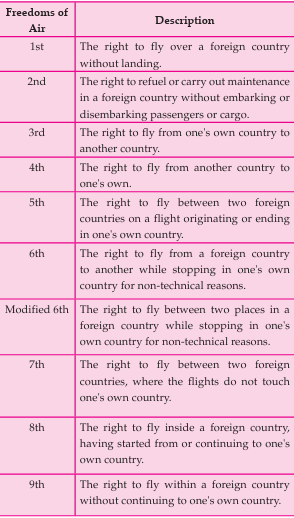
International Frameworks for Air Space
• The Principle of Air Space Sovereignty is established through the Paris Convention on the Regulation of Aerial Navigation (1919) and subsequently by Chicago Convention 1944.
• The Freedoms Of The Air, also called Five Freedoms Of Air Transport, are a set of commercial aviation rights granting a country’s airlines the privilege to enter and land in another country's airspace. They were formulated as a result of disagreements over the extent of aviation liberalisation in the Convention on International Civil Aviation of 1944, known as the Chicago Convention.
Transit Rights:
The first and second freedoms grant rights to pass
Under the Convention, contracting states agree to permit aircraft registered in the other contracting states and engaged in commercial non-scheduled flights to fly into their territory without prior diplomatic permission and, moreover, to pick up and discharge passengers, cargo, and mail.
through a country without carrying traffic that
originates or terminates there and are known as ‘transit rights’.
International Air Services Transit Agreement (IASTA) or “Two Freedoms Agreement”, was open to all signatories. At the end of 2017, the treaty was accepted by 133 countries.
• Open Skies Treaty 2002
• It establishes a program of unarmed aerial surveillance flights over the entire territory of its participants. The treaty allows gathering information about military forces and activities of concern to them. Currently, it has 34 party states.
• India has not signed the treaty.
• The idea of allowing countries to openly surveil each other is thought to prevent misunderstandings (e.g., to assure a potential opponent that one’s country is not about to go to war) and limit the escalation of tensions. It also provides mutual accountability for countries to follow through on treaty promises.
• The Open Skies regulations covers the territory over which the parties exercise sovereignty, including mainland, islands, and internal and territorial waters. Entire territory of a member state is open to observation. Observation flights may only be restricted for reasons of flight safety,not national security.
• In 2020, the United States withdrew from the treaty citing Russian violations of the treaty, and in 2021, Russia also withdrew, citing the U.S. withdrawal and the inability of member nations to guarantee that information gathered would not be shared with the U.S.
Indian Airspace
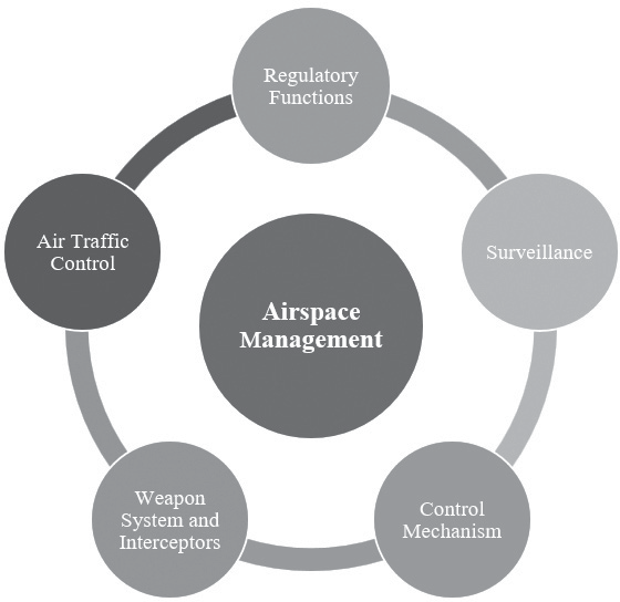
Figure: Key elements of Airspace Management
• Indian airspace encompasses a three-dimensional expanse of 40 million cubic kilometers, covering the mainland, islands, and territorial waters of the country.
•
The management of this airspace is both vital and complex due to factors such as the presence of hostile neighbors, rising air traffic driven by economic liberalization, and the necessity of monitoring trade routes.
• Like other airspaces worldwide, India's airspace has limited availability for civil aviation, as a significant portion is designated as prohibited, restricted, or danger zones.
• Prohibited ares
A prohibited area is established primarily for national security purposes and, in some cases, environmental concerns.
Aircraft are strictly forbidden from entering this zone under any circumstances.
• Restricted area
A restricted area is a defined section of airspace over land or territorial waters where aircraft operations are allowed only under specific conditions.
• Danger area
A danger area is a vast portion of airspace where military activities such as artillery drills, missile testing, and other exercises occur, necessitating restrictions on aircraft movement.
Security Challenges in the Indian Airspace
• Why we need to manage airspace?
• The security concerns surrounding Indian airspace were notably emphasized by the 1995 Purulia Arms Drop incident, followed by the 1998 downing of a Pakistan Air Force surveillance aircraft, resulting in the loss of all 17 personnel on board.
• Apart from these major events, occasional airspace violations by neighboring countries continue to surface from time to time.
• Globally significant incidents, such as the 9/11 attacks on the World Trade Center in the United States, where civilian aircraft were weaponized, the mysterious disappearance of Malaysia Airlines Flight MH370, and the shooting down of MH17 near Ukraine, serve as crucial reminders when strategizing Indian airspace management.
• Recent Violations:
• In May 2025, India faced a wave of drone strikes from Pakistan, targeting 26 locations across the north and west, including Srinagar airport and military sites. These were repelled through integrated air defense systems, but not without collateral impact: a civilian family was injured at Ferozpur.
• Regions like Rajasthan—notably Pokhran, Barmer, and Jaisalmer—were repeatedly targeted. Indian forces intercepted and destroyed these intrusions under Operation Sindoor,
• Punjab’s border saw hundreds of drone interceptions— many laden with contraband—by May 2025. These drones, often Chinese-made, are flown at higher altitudes and use zigzag descent to evade detection, presenting a growing security concern.
• In response to the Pahalgam terror attack on April 22, 2025, Indian authorities issued a NOTAM, restricting all Pakistani-registered and operated aircraft—including military flights—from entering Indian airspace between April 30 and May 23
• In June 2023, the Border Security Force (BSF) intercepted a Pakistan drone that entered Indian airspace in Punjab’s Tarn Taran district.
• Similarly, in a shocking incident, a Pakistani civilian airplane, PIA-308, unexpectedly entered Indian airspace in July 2023 due to the weather’s sudden deterioration. Similarly, IndiGo flight entered Pakistani airspace in June 2023.
• Fortify Rights, a human rights NGO, claimed that Myanmar’s Air Force had “dropped bombs on both sides of the Myanmar-India border” against an ethnic- Christian Chin minority rebel group.
• IN December 2022, Indian Air Force scrambled jets 2-3 times to prevent air violations by Chinese drones along the Line of Actual Control (LAC) in Arunachal Pradesh.
• In March 2022, Pakistan claimed an unarmed Indian supersonic missile took off from Sirsa and landed at a place 124 km within Pakistani territory.
The missile, it said, was cruising at an altitude of 40,000 feet and endangered passenger flights in both Indian and Pakistani airspace, and also civilians and property on ground.
• According to a 2005 agreement between India and Pakistan on pre-notification of flight testing of ballistic missiles, each country has to notify the other at least three days in advance of the flight test it wants to undertake whether surface-to-surface, land or sea launched missiles.
• It further states that launch sites should not fall within 40 km from either the International Boundary or the Line of Control and the planned impact area should not fall within 75 km.
Emerging threats from Drones
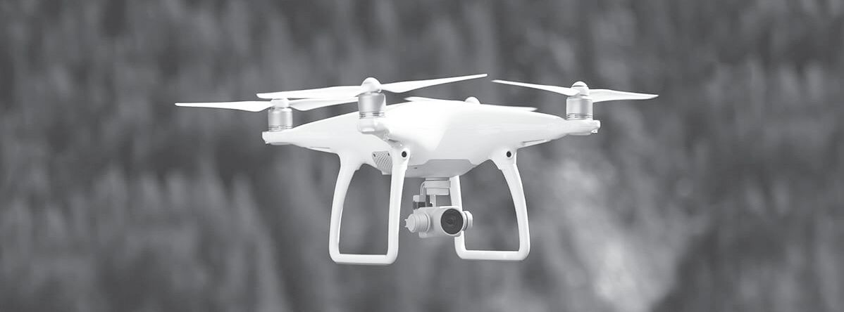
Figure: Drone
•
‘Drone’ is the common name of Unmanned Aerial Vehicle (UAV) which is a flying robot that is either remote or software controlled.
• Drones are being used for smuggling weapons, ammunition, counterfeit currency and drugs.
• The BSF detected weapons dropped by a suspected Pakistan drone in Jammu. One AK-47 assault rifle, one pistol, one magazine, and 15 rounds for a 9 mm weapon were recovered 250 m inside Indian territory.
• significantly felt across the Punjab border, where narco–terrorism has intensified.
• Drones for terrorist attacks
In June 2021, Air Force Station Jammu was attacked by two low-flying drones that carried Improvised Explosive Devices (IEDs); one exploded on the roof of a building and caused minor damage while the other in an open area.
• Drones for Surveillance:
• Drones have emerged as a new strategic tool used by Pakistan to gain an advantage in the border conflict with India.
• India’s Border Security Force (BSF) reported more than 268 drone sightings in 2022, compared to 109 in 2021 and 49 in 2020.
• Detection Challenges:
• Conventional radar systems are not meant for detecting small flying objects, and, even if they are calibrated that way, they might confuse a bird for a drone and the system may get overwhelmed.
• Currently, border forces in India largely use eyesight to spot drones and then shoot them down.
• It is easier said than done as most rogue drones are very small and operate at heights difficult to target.
• Drone Attacks that Made Headlines Worldwide:
• 2016- Weaponized drone used by ISIS in Iraq: ISIS used drones to attack Iraqi military troops during the campaign over Mosul.
• 2018- Caracas drone attack: Venezuelan President Nicolas Maduro survived a weaponized drone attack which was an attempt to assassinate the President.
• 2019- Saudi oil sites hit by Yemen Houthi drones: Houthi, a Yemen rebel group, hit Abqaiq, the world’s largest oil processing facility in Saudi Arabia.
• 2021- Hamas’ Kamikaze drone attack on Israel: In May 2021, Hamas, the Palestinian military group, launched weaponized drones named ‘Shehab’ on Israel. However, those drones were intercepted and disabled by the Iron Dome System installed in Israel.
2023-
• Kremlin Drone attack- two explosive drones allegedly targeted the Kremlin in Moscow and were shot down.
Iran- Several unidentified drones attacked an ammunition factory.
MEASURES TAKEN BY THE GOVERNMENT TO SECURE THE AIR SPACE
Domestic Measures
• The Directorate General of Civil Aviation is the regulatory body in the field of Civil Aviation primarily dealing with safety issues.
• Functions of DGCA
To meet State obligations under ICAO
Regulation of air transport services to/from/ within India
Enforcement of civil air regulations, air safety and airworthiness standards.
Surveillance & Enforcement Division (SED) in DGCA Headquarters is the office coordinating and consolidating the “DGCA Safety Oversight System”.
• Under the Indian Constitution, the subject “civil aviation” comes in the Union List. Thus, any criminal activity unlawful interference against civil aviation occurring anywhere in India is the Union Government’s responsibility.
LEGISLATIVE MEASURES
• The Anti-Hijacking Act, 2016
• It replaced the Anti Hijacking Act, 1982.
• It aims to enforce the Hague Hijacking Convention, 1970 and the 2010 Beijing Protocol Supplementary to the Convention.
• It defines the offence of hijacking, prescribes punishment for it and allows Indian courts to take cognizance of extraterritorial hijacking if a territorial or nationality nexus can be established.
• Sets out the principle of ‘aut dedere aut judicare’ — a state that is a party to the Convention must prosecute an aircraft hijacker if no other state requests his or her extradition for prosecution.
• The key new introductions are the death penalty, life sentence for hoax calls, and a wider definition for aircraft “in service”.
• The Suppression of Unlawful Acts Against Safety of Civil Aviation Act, 1982
• This Act was passed by the Indian Parliament to give effect to the Convention for the Suppression of Unlawful Acts against the Safety of Civil Aviation, adopted in Montreal, 1971.
• Spells out offences at airports.
• Air transport’s high-profile operations also make it a prime target for terrorism.
• Flexible Use of Airspace (FUA)
• Optimum use of national airspace by fully implementing the concept of Flexible Use of Airspace (FUA) has been suggested by the Ministry of Civil Aviation under the Atma Nirbhar Bharat vision.
•
Indian Air Force (IAF) controls 30% of national airspace out of which 30% has been released as upper airspace under Flexible Use of Airspace. Regional Airspace Management Cells (AMCs) are established at Delhi and Chennai and the National AMC is established at Delhi.
• Till date, 128 Conditional Routes (CDRs) have been promulgated under FUA. This will lead to significant savings in flight time, fuel usage and reduction in carbon emission.
• Air Defense Identification Zones (ADIZ)
• The air defense identification zone is the airspace of the country as well as additional areas of water and land in which a country tries to identify, locate, and control any civil aircraft except military aircraft in the interest of national security
• India has established its own ADIZ and procedures for identification, location and control of all the aircrafts within its airspace.
• 6 Zones: There are total six ADIZs covering Indian Territory namely,
• North
• West
• Central
• East
• South: It also includes airspace over and up to the territorial waters of Lakshadweep Islands
• South- East.
• Permitted Routes
• All aircrafts flying in air space above the Indian Territory, including territorial waters adjacent thereto are required to follow the established ATS routes.
• Pilots are cautioned not to fly in the air space over Indian Territory within 15 nm of the border of India except when following an ATS or specifically permitted
• Interception of Action
• If an aircraft penetrates into/operates within an ADIZwithout Air Defense Clearance, strays into a restricted area/prohibited area/danger area or fails to inform the Air Traffic Control Centre about its deviation/intended deviation from the route, it will be liable to interception by fighter aircraft.
Drone Policy in India
• Civil Aviation Requirements (National Drone Policy 1.0) 2018:
• The CAR on Operation of Civil Remotely Piloted Aircraft System was issued by the DGCA under Rule 133A of the Aircraft Rules 1937.
• It categorized drones into 5 categories- nano (up to 250g, micro (250g to 2 kg), small (2 kg to 25 kg), medium (25 kg to 150 kg), and large(more than 150 kg).
It also introduced various requirements for flying drones, like UAO Permit, Unique Identification Number, No Permission-No Take Off Policy, etc.
• National Counter Rogue Drone Guidelines 2019:
• These Guidelines provide measures to prevent the misuse of drones; for example, it states the importance of drone detection and neutralization mechanisms, and strict enforcement of rules.
• It also discusses the limitations of the present drone response mechanism against drone misuse.
• Unmanned Aircraft Systems Rules 2021 (National Drone Policy 2.0):
• In addition to the categorization of drones in the National Drone Policy 1.0, these Rules further categorize Unmanned Aircraft Systems into- Airplane, Rotorcraft, Hybrid, Autonomous Aircraft Systems, etc.
• It also introduces some requirements for nano-drones.
Unmanned Aircraft Systems Rules 2021
• The liberalised Drone Rules, 2021 notified, drone airspace map published, nearly 90% of Indian airspace opened as a green zone for drone flying up to 400 feet.
• Eligibility: Authorizes individuals, company and government agencies to trade, own, operate, or manufacture drones in India:
• Individual: Indian citizen of or above 18 years of age;
• In case of a company or body corporate, it should be registered and have a principal business place in India, and the Chairman and the at least two-thirds of the directors must be Indian citizens;
• Central or State Govt. agencies, local authorities, etc.
• Registration: Mandatory registration of UAS and applicant gets a Unique Authorization Number (UAN), which may be valid for a maximum of 10 years.
• Mandatory security requirements for drones
• Global Navigation Satellite System (GNSS);
• Fire-resistant Identification plate for engraving Unique Identification Number (UIN);
• Flight Data Logging Capability;
• Real-Time Tracking System;
• The 360-degree Anti-Collision Avoidance System;
• Secondary Surveillance Radar (SSR).
• No-Permission, No-Takeoff (NPNT) Policy:
• All drones (except nano) must be “no-permission, no-take off” policy compliant;
• Before every flight, the operator must get permission to take off from the DigitalSky Platform mobile application.
• Height of the flight
• Nano drone- Up to 15 meters AGL or a maximum speed of 15m/s and maximum of 100 meters distance from the remote pilot;
•
Micro drone- Up to 60 meters AGL or a maximum speed of 25m/s;
• Small done- Up to 120 meters AGL or a maximum speed of 2m/s;
• Medium/ Large drone- As per the conditions specified in the Operator Permit issued by DGCA.
• Permit:
• Except for nano drones, only the operators who have the ‘UAS Operator Permit’ issued by the DGCA can operate a drone.
• Operators must have the Remote Pilot Licence to apply for the Permit.
• License:
• Licenses are of two types – Remote Aircraft Pilot Licence (RAPL) and Student Remote Pilot License (SRPL).
• The student must possess SRPL to commence the remote flying training; once the training and examination are complete, the trainee gets the RAPL, on the receipt of which he will get the Permit.
• RAPL’s validity is up to 10 years.
• No-Fly Zones: Some of the no-fly zones are:
• Within 5km from the perimeter of international airports at Mumbai, Delhi, Chennai, Kolkata, Bengaluru, Hyderabad;
• Within 3km from the perimeter of any civil, private, or defence airports;
• Within Prohibited, Restricted and Danger Areas as notified by AAI;
• Within 25km from international border including Line of Control (LoC), Line of Actual Control (LAC), Actual Ground Position Line (AGPL);
• Within 3km from the perimeter of military installations/ facilities;
• Within 2km from the perimeter of strategic locations/ vital installations notified by Ministry of Home Affairs.
• Challenges in UAS Rules 2021
• Implementation: Drones without the mandated equipment like NPNT hardware and firmware, 360 degrees anti-collision system, GNSS, etc., are still being sold in the market without any hiccups; most commercial drones are sold on the internet are made in China.
• Exorbitant requirements: Compliance with difficult requirements will raise the price of drones.
• Training cost: drone license for training itself costs 30,000.
Technology to Counter Drone Attacks
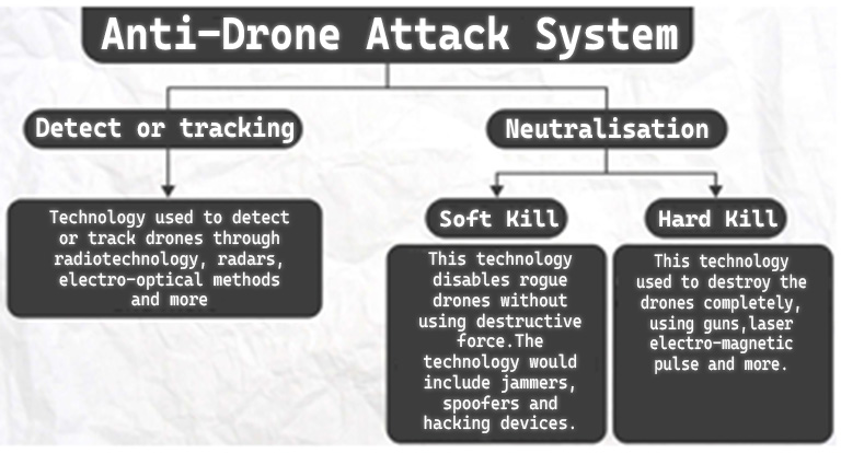
Figure: Anti-Drone Attack System
• DRDO’s Counter-Drone (D-4) System: developed in 2019, has capabilities for Hard Kill (destroying a drone with lasers) and Soft Kill (jamming a drone’s signals). It has a 360 radar that can detect micro drones up to 4 km, and other sensors to do so within 2 km. Its Soft Kill range is 3 km and Hard Kill range between 150 m and 1 km.
• Swarm (Smart War fighting Array of Reconfigurable Modules) Drones are a collection of small and lightweight aerial vehicles equipped with advanced communication systems and a variety of payloads for a collaborative
attack against an enemy unit.
• Supplied by an Indian start up – Bengaluru based NewSpace Research & Technologies
• The benefit of such a swarm is that if one drone drops out or a few crashes due to enemy counter measures, the group can rearrange or self-heal itself to continue
undertaking the mission till the last UAV in air.
• Rustom-2 Indigenous UAV also known as Tapas-BH (Tactical Airborne Platform for Aerial Surveillance- Beyond Horizon 201.
• Designed and Developed by the Aeronautical Development Establishment (ADE),Hindustan Aeronautics Ltd and Bharat Electronics Limited.
• Developed to carry out surveillance and reconnaissance roles and is capable of carrying different combinations of advanced payload and capable of auto-landing among others.
• It is being designed to acquire real-time, high- quality pictures and signal intelligence from fields of concern at medium to long ranges.
•
The Naval Anti-Drone System (NADS) is the first fully indigenous anti-drone system, developed by DRDO.
• The Indian Navy utilizes Israel’s SMASH 2000 Plus system, which is primarily mounted on assault rifles to provide a hard-kill capability.
• Indrajaal is an autonomous drone defense dome, developed by the Indian private firm Grene Robotics.
International Civil Aviation Regulations and Bodies
• Annex 17: India’s National Civil Aviation Security Regulations are based on the Annex 17 of the Chicago Convention 1944. Under the Annex 17, the contracting states shall ensure the security of international passengers through well trained officers, supporting facilities, safeguard of airport and ground facilities at all international airports, and effective implementation of national civil aviation training programmes.
• The Tokyo Convention Act, 1975
• This Act was passed to give effect to the Convention on Offences and Certain Other Acts Committed on Board Aircraft, adopted in Tokyo on 14 December 1963.
• Defines offences committed on the board a flight to be prosecuted in India is so covered under Indian laws.
• Recognizes the jurisdiction of state of registration.
• Allows commander of the aircraft to take charge for safety of the aircraft and its passengers.
• International Civil Aviation Organisation
• ICAO is a United Nations (UN) specialized agency, established in 1944, which laid the foundation for the standards and procedures for peaceful global air navigation.
• The Convention on International Civil Aviation was signed on 7th December 1944 in Chicago to setup ICAO.
• It’s one of the objectives is to foster the planning and development of international air transport so as to ensure the safe and orderly growth of international civil aviation throughout the world.
• India is a contracting State to the Chicago Convention on International Civil Aviation and a member of the International Civil Aviation Organisation (ICAO).