India’s Maritime Security
Maritime security is very important in terms of national security as having the strongest navy against other states makes you more powerful than having a powerful military army and air force. This is because trade through sea route is the largest transportation method. This in turn leads to many threats to maritime security. Threats to maritime security varies from nation to nation. It is a term that encompasses the aspects and issues arising.
INDIA’S MARITIME SECURITY
• India has a vast coastline of 11098.81 km with nearly 1,200 islands and a large EEZ (Exclusive Economic Zone) of about 2 million sq. km. The Annual Report 2021-22 on Internal Security by Ministry of Home Affairs mentions following Coastal States and their Boundaries-
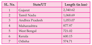
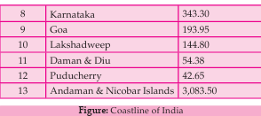
• The Indian Ocean, through which much of the world’s ships transit, is distinguished by a land rim on three sides.
• Maritime boundaries have strategic, economic, and environmental implications.
• Strategic Significance of Indian Ocean
• Maritime access to this region is restricted to specific choke points that connect it to the Arabian Sea, the Bay of Bengal, and the Southern Indian Ocean.
• India holds a strategic position, flanking the first two
regions while centrally overseeing the third.
• Its peninsular geography naturally extends its influence across vast maritime areas in all directions, further enhanced by the Andaman & Nicobar and Lakshadweep island chains.
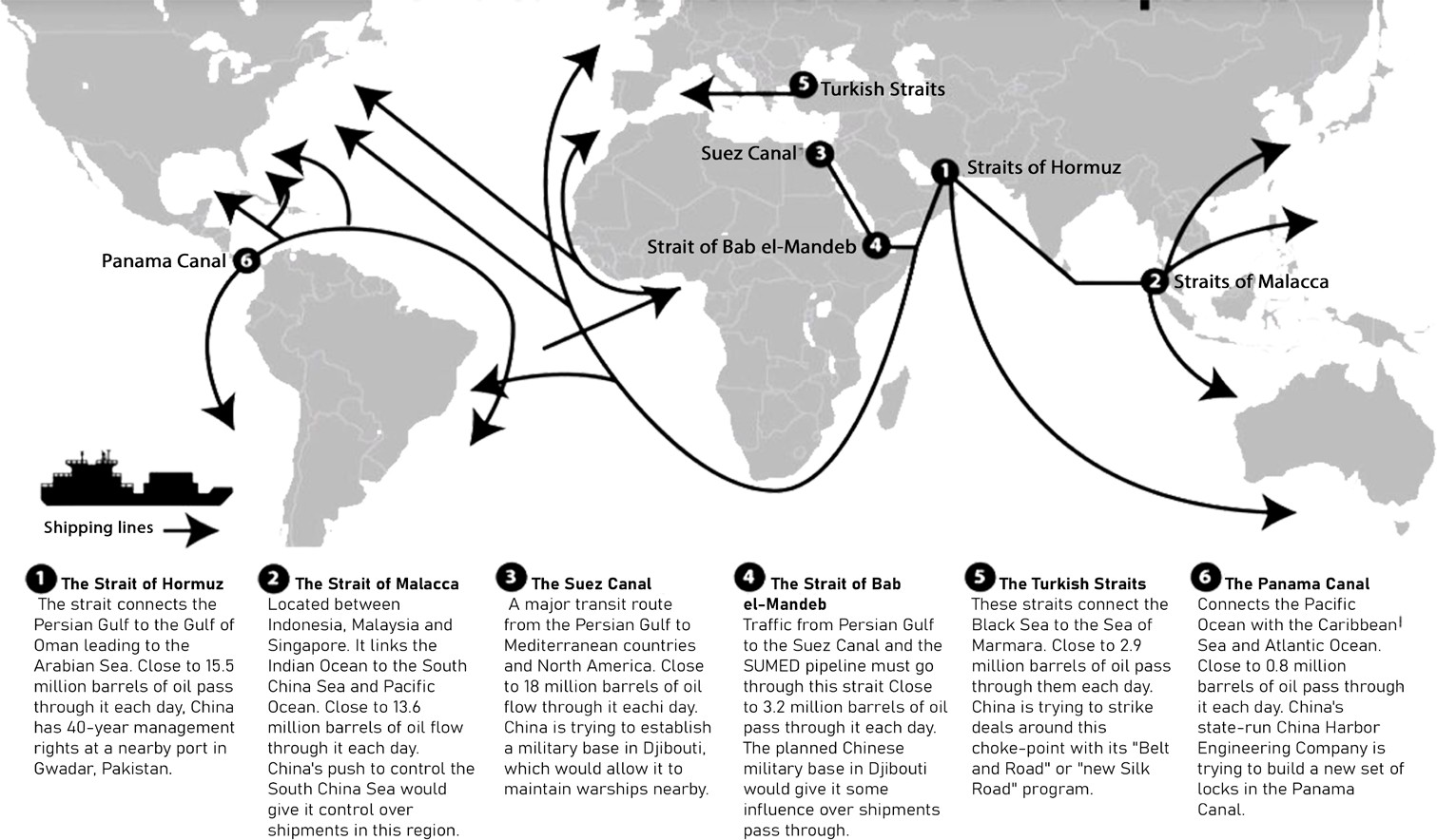
Figure: Indian Ocean Chokepoints
• India's central location within the Indian Ocean Region (IOR) allows it to dominate key International Shipping Lanes (ISL), offering a strategic advantage. This positioning places the outer edges of the IOR and critical choke points at nearly equal distances from India, enabling effective reach, mobility, and sustained operations of its maritime forces across the region.
• As a result, India is well-placed to shape the maritime environment and safeguard its national interests within its maritime domain.
• However, the vastness of this domain necessitates substantial resources and investment to secure it against both conventional and unconventional threats.
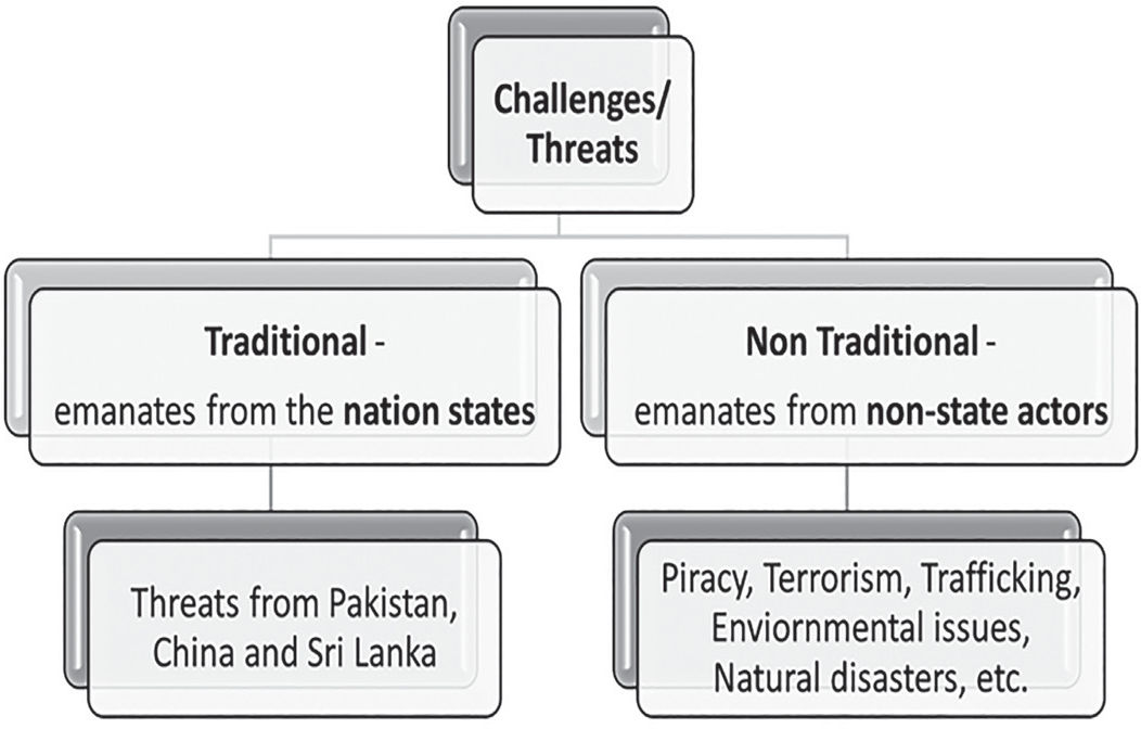
Figure: Maritime Security Challenges/Threats to India
Standard Terms Related to International Maritime Waters
• Internal Waters
• The term refers to all waters landward of the baseline
(e.g., low water line) and all harbours.
• Any law in force in the country, including the common law, shall also apply in its internal waters and airspace above its internal waters.
• The right of innocent passage does not exist here.
• Territorial Waters
• The sea within the distance of 12 nm from the baseline.
• It is a fully sovereign territory of the state. However, foreign ships, both civilian and military, are permitted ‘innocent passage’ through it.
• Submarines and other underwater vessels are required to navigate on the surface and show their flag.
• Contiguous Zone
• This zone refers to the sea beyond territorial waters but within a distance of 24 nm from the baseline.
• Within this contiguous zone and the airspace above it, the nation has the authority to enforce all measures
necessary to prevent violations of fiscal, customs, immigration, or sanitary laws, as well as to impose penalties for such violations.
However, this jurisdiction extends only to the ocean’s surface and seabed, excluding any rights over airspace and outer space.
• Exclusive Economic Zone
• It is a term for the sea beyond the territorial waters but within a distance of 200 nm from the baseline, except when the space between two countries is less than 400 nm.
• This zone is subjected to any other laws of the country, in respect of all natural resources, the same rights and powers it has in respect of territorial waters.
• State has special rights over the exploration and use of both living and non-living marine resources, including energy production from water and wind.
• International Waters
• It is not a defined term in international law.
• It is an informal term, which sometimes refers to
waters beyond the “territorial sea” of any country.
• High Seas
• The United Nations Convention on the Law of the Sea, established in 1982, defines the "high seas" as all areas of the ocean that lie beyond a state's Exclusive Economic Zone (EEZ), territorial waters, internal
waters, or the archipelagic waters of an archipelagic state.
• The high seas are regarded as part of the "Global Commons" or the "common heritage of all mankind," remaining outside the jurisdiction of any single nation. In this zone, states are permitted to engage in activities for peaceful purposes, including navigation, marine scientific research, and undersea exploration.
• Archipelagic State
• Archipelagic States are composed of groups of islands forming a state as a single unit, with the islands and the waters within the baselines as internal waters.
• The Bahamas, Fiji, Indonesia, Papua New Guinea, and the Philippines are the five original sovereign states that qualified as the archipelagic states under UNCLOS in 1982. As of 20 June 2015, a total of 22 sovereign states have sought to claim archipelagic status.
• Archipelagic Waters
• For a country that is an archipelago or has an archipelago under its jurisdiction, a baseline is established by connecting the outermost points of the islands, provided they are in close proximity. The waters enclosed within this boundary are referred to as Archipelagic Waters.
• These waters hold a distinct legal status, as they are neither classified as internal waters nor as territorial sea.
• While an archipelagic state exercises sovereignty over them, other nations have the right to navigate through these waters under the principle of Innocent Passage. Additionally, in routes customarily used for international navigation, a broader right known as archipelagic sea lanes passage applies, similar to transit passage through straits. Neighboring states may also engage in traditional fishing and other non-navigational activities within archipelagic waters.
• The territorial sea, contiguous zone, Exclusive Economic Zone (EEZ), and continental shelf are measured from archipelagic baselines.
The areas located on the landward side of these baselines are considered the internal waters of the archipelagic state. However, it is important to emphasize that archipelagic waters are distinct from internal waters
• Innocent Passage
• Innocent passage, as defined under UNCLOS, permits vessels to transit through the archipelagic and territorial waters of another state, subject to certain limitations.
• This principle grants ships and aircraft the right to enter and move through a state's territory, provided their passage does not disrupt the peace, order, or security of the coastal state.
• According to India's Territorial Waters, Continental Shelf, Exclusive Economic Zone, and Other Maritime Zones Act of 1976, all foreign vessels, except warships, submarines, and other underwater craft, are entitled to the right of innocent passage through India's territorial waters.
• Freedom of Navigation (FON)
• Under the law of the sea, a fundamental principle states that vessels bearing the flag of any sovereign nation shall not be subjected to interference by other states, except in cases permitted under international law.
• In the context of international law, this principle is defined as the freedom of vessels to navigate, access ports, utilize facilities such as docks, load and unload cargo, and transport goods and passengers without unjustified restrictions
Innocent Passage vs Freedom of Navigation (FON)
• While both Innocent Passages and FON operations involve vessels traversing seas claimed by a foreign state, under innocent passage implies a concession on traveling through territorial waters of another state.
• Both innocent passage and FON operations challenge a state’s-imposed limitations, but innocent passage acepts that the area is within a state's waters, while a FON operation can be used to challenge a state's territorial claim to an area.
• Artificial Island
• Artificial islands, installations, and structures do not hold the legal status of natural islands. They do not have their own territorial sea, nor do they influence the boundaries of the territorial sea, exclusive economic zone (EEZ), or continental shelf.
• According to the United Nations Convention on the Law of the Sea (UNCLOS), artificial islands are not classified as harbor works (Article 11) and fall under the jurisdiction of the nearest coastal state if located within 200 nautical miles (370 km) (Article 56). These structures do not qualify as islands in terms of territorial waters or EEZ rights, and only the coastal state has the authority to permit their construction (Article 60). However, in areas beyond national jurisdiction on the high seas, any state has the right to build artificial islands (Article 87).
• However, artificial islands, installations, and structures do not hold the same legal status as natural islands.
• Several countries, including the Netherlands and the Maldives, have been constructing artificial islands to drive economic growth and mitigate the risks posed by rising sea levels.
Figure: Maritime Security Challenges/Threats to India
• These waters hold a distinct legal status, as they are neither classified as internal waters nor as territorial sea.
• While an archipelagic state exercises sovereignty over them, other nations have the right to navigate through these waters under the principle of Innocent Passage. Additionally, in routes customarily used for international navigation, a broader right known as archipelagic sea lanes passage applies, similar to transit passage through straits. Neighboring states may also engage in traditional fishing and other non-navigational activities within archipelagic waters.
• The territorial sea, contiguous zone, Exclusive Economic Zone (EEZ), and continental shelf are measured from archipelagic baselines.
• The areas located on the landward side of these baselines are considered the internal waters of the archipelagic state. However, it is important to emphasize that archipelagic waters are distinct from internal waters.
• Innocent Passage
• Innocent passage, as defined under UNCLOS, permits vessels to transit through the archipelagic and territorial waters of another state, subject to certain limitations.
• This principle grants ships and aircraft the right to enter and move through a state's territory, provided their passage does not disrupt the peace, order, or security of the coastal state.
According to India's Territorial Waters, Continental Shelf, Exclusive Economic Zone, and Other Maritime Zones Act of 1976, all foreign vessels,
Maritime Boundary
• Maritime Boundaries can be divided into three groups based on their legal status:
• Sovereign Territorial Waters:
They fall under the sovereignty and authority (exercising power) of a coastal State such as Internal Waters, Territorial Sea, and Archipelagic Waters.
• Mixed Legal Regime:
They fall under both the jurisdiction of the coastal State and under the international law, such as Contiguous Zone, the Continental Shelf and the Exclusive Economic Zone.
• International High Seas:
High Seas refers to the ocean water column that lies beyond the boundaries of any one country, also known as Areas Beyond National Jurisdiction ABNJ). It is an area that can be used by all States (including land-locked ones) equally.
• Maritime spaces belonging to same group may have different legal regime. For instance, international straits and canals have their own legal status as well.
• The Constitution (40th Amendment) Act of 1976 introduced a revised Article 297, granting the Union of India ownership over all land, minerals, and valuable resources located beneath the ocean within India's Territorial Waters, Continental Shelf, and Exclusive Economic Zone (EEZ).
• The key distinction between the Territorial Sea and the Exclusive Economic Zone (EEZ) is that the former grants full sovereignty over the waters, while the latter provides only "sovereign rights," which apply exclusively to resources beneath the sea’s surface.
(ABNJ). It is an area that can be used by all States (including land-locked ones) equally.
• Maritime spaces belonging to same group may have different legal regime. For instance, international straits and canals have their own legal status as well.
• The Constitution (40th Amendment) Act of 1976 introduced a revised Article 297, granting the Union of India ownership over all land, minerals, and valuable resources located beneath the ocean within India's Territorial Waters, Continental Shelf, and Exclusive Economic Zone (EEZ).
• The key distinction between the Territorial Sea and the Exclusive Economic Zone (EEZ) is that the former grants full sovereignty over the waters, while the latter provides only "sovereign rights," which apply exclusively to resources beneath the sea’s surface.
•
•
Traditional Threats
Traditional Threats
• Traditional threats are the military threats that are faced by a nation from another nation that that has a negative effect on its sovereignty, integrity, trade, etc.
• Traditional threats affect only the state whereas non- traditional threats affect the state, individual and the entirety of humanity.
• Non-traditional threats cover other aspects like terrorism, piracy, natural disaster, drug trafficking, illegal migrants etc.
INDIA-PAKISTAN
• The maritime boundary between India and Pakistan remains undefined over 70 years after independence and partition.
• Sir Creek Issue
• Sir Creek is a 96 km strip of water in the marshes of the Rann of Kutch in Gujarat. The dispute lies in the interpretation of the maritime boundary line between Pakistan and India.
• While Pakistan claims Sir Creek in its entirety and argues that the Bombay Resolution of 1914 supports its claims.
• On the other hand, India states that the division of the creek should follow the Thalweg principle: it supports dividing the creek in the middle since the creek is navigable during high tide.
• It is an estuary in the marshes of Rann of Kutch, opening into the Arabian Sea, which separates India’s Gujarat and Pakistan’s Sindh.
• Importance of Sir Creek
• Fishing: The disputed region of Sir Creek has very little strategic or militarysignificance but the region is rich in fishing resources, considered to be one of the largest fishing grounds in Asia.
• Ecological Importance: It is home to Flamingoes and other species of migratory birds in the winters.
• Natural Resources: The region is expected to be rich in hydrocarbon and shale gas with immense economic potential.
•
Exclusive Economic Zone (EEZ): If boundary gets defined it would help in determining the maritime boundaries which will further decide the limits of EEZ and Continental shelf.
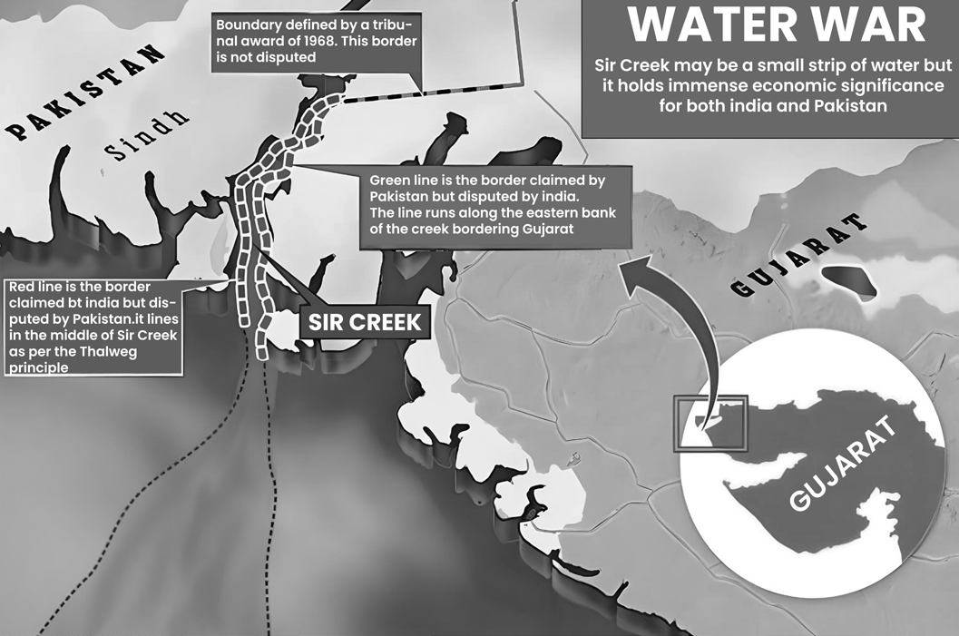
Figure: Sir Creek boundary
Dispute
• At the heart of the dispute is the differing interpretations of the maritime boundary line between the two neighbouring countries.
• In 1965, a dispute in this region contributed to the full- fledged war between India and Pakistan.
• Arbitration & Dispute Resolution
• 1968 Indo-Pak Western Boundary Case Tribunal Award
• Resolved the larger Great Rann of Kutch border claims of India and Pakistan, which also covered Sir Creek.
• The tribunal upheld 90 per cent of India’s claim to the entire Rann leaving the boundary to the south unresolved.
• From 1997 to 2012, there have been twelve rounds of talks between the two nations, without a breakthrough.
• Joint surveys of the region were conducted between 2005 and 2007. Since neither country has made any concessions, India has suggested that the maritime boundary be demarcated first in accordance with the provisions of the ‘Technical Aspects of Laws of the Sea’ (TALOS).
• However, Pakistan seeks to resolve the dispute through international arbitration, a move India has firmly rejected, maintaining that it is strictly a bilateral matter.
• India maintains that under Shimla Agreement 1972, all bilateral disputes should be resolved without the intervention of third parties.
• Challenges in Sir Creek
• With both nations unable to reach a consensus on the precise boundary, the disagreement extends into the Arabian Sea, resulting in a large expanse of contested waters. This region has become a hotspot where the
struggles of fishermen, terrorist activities, and global drug syndicates intersect.
• There are signs that this area could be one of the most active hubs for drug trafficking worldwide.
• Two channels, the Harami Nala and Bondho Dhoro, are of specific concern to India for preventing infiltration and illegal activities.
• Security Forces guarding Sir Creek
• BSF: The Indian military Border Security Force (BSF) patrols Sir Creek up to midstream using floating border posts, amphibious vehicles, and foot travel by the Creek Crocodile Commandos.
• ICG: The coastal area of Sir Creek is manned by the Indian Coast Guard.
• Indian Navy: The larger open sea beyond is patrolled by the Indian Navy.
INDIA-SRI LANKA
• The maritime boundary between India and Sri Lanka was established though a pair of bilateral agreements that were reached in 1974 and 1976 and spans some 288 km from the tripoint with the Maldives in the west to the 200 nautical mile limit of India and Sri Lanka in the east.
• Palk Strait
• The maritime border that exists between Sri Lanka and India is a water body called the Palk Strait. It is a strip of ocean that separates Tamil Nadu in India from the Mannar district in Sri Lanka. The width of this is between 53 km and 80 km. Palk Strait is divided by the International Maritime Boundary Line (IMBL).
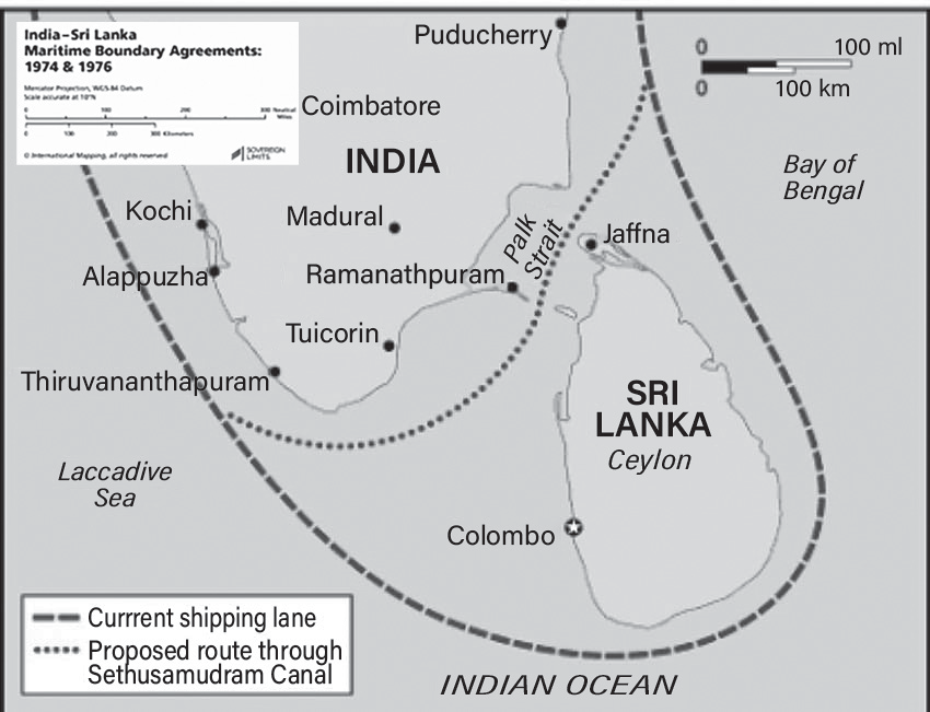
Figure: India-Sri Lanka Maritime Boundary Agreements
• However, there are few issues still left having direct bearing on the livelihood of the people residing there.
Fishing Dispute
• India and Sri Lanka are separated by only 12 nautical miles
• There have been instances of fishing by Indian fishermen in Sri Lankan waters. There is also the issue of Indian fishermen having used mechanised trawlers, which deprived the Sri Lankan fishermen (including Tamils) of their catch and damaged their fishing boats. Sri Lankan authorities have retaliated by arresting the fishermen and seizing the boats.
• A Joint Working Group was established to address issues concerning Indian fishermen inadvertently entering Sri Lankan territorial waters. Its objectives include formulating measures to prevent the use of force against them, facilitating the prompt release of seized boats, and exploring potential bilateral agreements for licensed fishing.
• Following the defeat of the LTTE, there has been a rise in conflicts involving Indian fishermen, both with their Sri Lankan counterparts and the Sri Lankan Navy.
• Allegations have surfaced regarding the use of excessive force, including firearms, to deter illegal fishing activities.
• 1974 Kachchatheevu/Katchatheevu Ceded to Sri Lanka
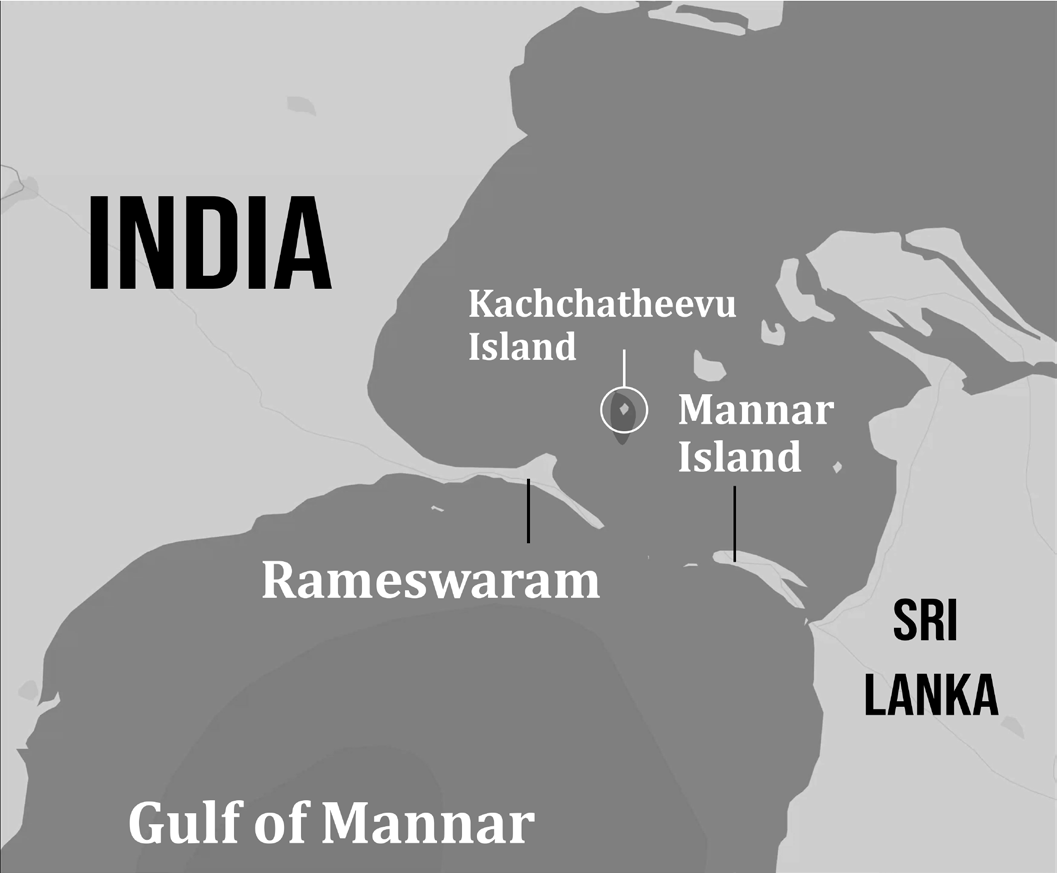
Figure: Kachchatheevu Island given by India to Sri Lanka
• Kachchatheevu is a 285-acre uninhabited speck in the Palk Strait, between India and Sri Lanka. It lies northeast of Rameswaram, about 33 km from the Indian coast.
• Kachchatheevu is not suited for permanent settlement
as there is no source of drinking water on the island.
• In 1974, under ‘Indo-Sri Lankan Maritime agreement’, Indira Gandhi ‘ceded’ Kachchatheevu to Sri Lanka. However, Indian fishermen were still allowed to access Kachchatheevu.
• Another agreement in 1976, barred either country from fishing in the other’s Exclusive Economic Zone.
•
The grant of “Kachchatheevu” has endangered the Indian fishermen’s right over the rich fishing waters.
INDIA- BANGLADESH
• Soon after exiting the territorial sea, the boundary was shifted slightly to the south, to follow a directional azimuth of N 177 30 E, until intersecting with the Bangladesh–Myanmar maritime boundary on the outer continental shelf. Bangladesh and India also share a land boundary.
• India and Bangladesh, with different perceptions of their maritime boundaries and Exclusive Economic Zone, engaged in eight rounds of bilateral negotiations since 1974, which remained inconclusive until 2009 when both agreed to undergo arbitration under the UNCLOS.
• On 7 July 2014, Arbitration Tribunal resolved the dispute in Bangladesh’s favour, which was amicably accepted by both sides, thus ending the dispute. Dispute also included South Talpatti (also called New Moore), a small uninhabited offshore sandbar that emerged as an Island in the aftermath of the Bhola cyclone in 1970, and disappeared around March 2010.
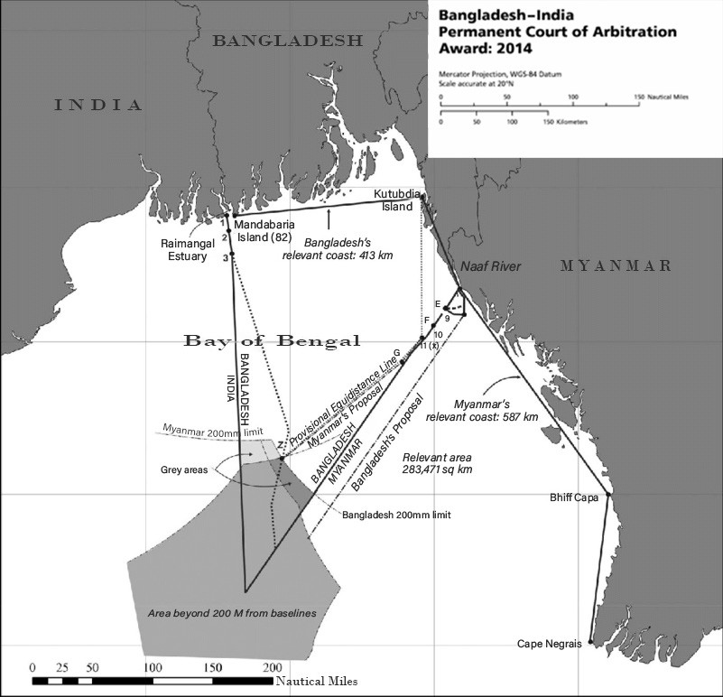
Figure: India-Bangladesh Maritime Boundary
INDIA-CHINA
Introduction
• The maritime aspect of security threats from China to India is a relatively recent concern.
• The rapid economic expansion of both nations has led to a growing demand for energy and raw materials, most of which are transported via sea routes.
• As a result, both countries are prioritizing the security of sea lanes to ensure the smooth and uninterrupted movement of trade and energy supplies.
• This has led to new responsibilities for the Indian Navy in the South China Sea, while the People's Liberation Army (PLA) Navy has extended its presence into the Indian Ocean.
• Examining China’s trade routes reveals that 40% of its oil imports pass through the Strait of Hormuz, while 82% transit via the Malacca Strait.
• These critical maritime corridors fall within the operational reach and influence of the Indian and US Navies.
• In response, China is expanding its footprint in the Indian Ocean through its ‘String of Pearls’ strategy, which appears to be an effort to encircle and restrict India’s influence in the region.
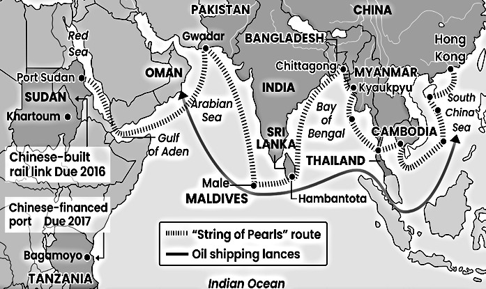
Figure: String of Pearls
India’s Necklace of Diamonds
This strategy aims at garlanding China or in simple words, the counter encirclement strategy. India is expanding its naval bases and is also improving relations with strategically placed countries to counter China’s strategies.
Changi Naval Base, Singapore: From 2018 onwards, while sailing through the South China Sea, the Indian Navy can refuel and rearm its ship through this base.
Sabang Port, Indonesia: In 2018, India got the military access to Sabang Port which is located right at the entrance of Malacca Strait. This strait is one of the world’s famous choke point. A large chunk of trade and crude oil passes
on to China through this region.
• Duqm Port, Oman: In 2018, India got another military access after Sabang Port in Indonesia. The Duqm Port is located on the south-eastern seaboard of Oman. The port facilitates India’s crude imports from the Persian Gulf. In
addition to this, Indian facility is located right between the two important Chinese pearls-- Djibouti in Africa and Gwadar in Pakistan.
• Assumption Island, Seychelles: In 2015, India and Seychelles agreed upon the development of the naval base in this region. This gives the military access to India. This base is of strategic importance to India as China desperately wants to increase its presence in the African continent through the maritime silk route.
• Chabahar Port, Iran: In 2016, Prime Minister Modi signed an agreement to built this port. The port provides access to Afghanistan and an important trade route to Central Asia.
• India’s Relations with Strategic IOR Countries
• Mongolia: Prime Minister Modi is the first Indian Prime Minister to visit this country. Both the countries have agreed and will collaborate to develop a bilateral air corridor using India’s credit line.
• Japan: India and Japan have jointly declared to built the
Asia-Africa Growth Corridor (AAGC).
• Vietnam: India is maintaining good relations with Vietnam and has so far sold Brahmos Missile and 4 patrol boats to the country.
INDIA-MYANMAR
• The maritime boundary between India and Myanmar runs through the Andaman Sea, Coco Channel, and Bay of Bengal and was established through a bilateral agreement in 1986.
• The boundary separates India’s Andaman and Nicobar Islands from the maritime entitlements of Myanmar and follows a modified equidistance line for 593 nautical miles.
• The boundary begins at Point 1, coincident with the tripoint with Thailand, which was officially established by trilateral agreement that was reached on 27 October 1993.
• India and Myanmar have maritime Exclusive Economic Zones in each other›s vicinity. Landfall
Island, India’s northernmost Island in Andaman and Nicobar is 40 kilometres (25 mi) south of Coco Islands of Myanmar.
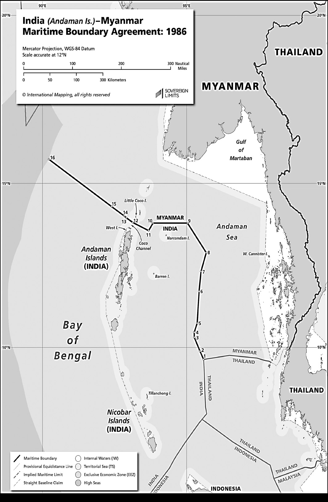
Figure: India-Myanmar Maritime Boundary Agreement
INDIA-INDONESIA
• An initial segment of the maritime boundary nearest the coasts of the States’ relevant islands was delimited through a bilateral agreement that was reached on 17 December 1974.
• The boundary was then extended in 1977 in both directions; to the northeast into the Andaman Sea, and to the southwest into the Indian Ocean.
• The India–Indonesia maritime boundary is almost 300 nautical miles in length and delimits the overlapping maritime entitlements generated by India’s Nicobar Islands and Indonesia’s Sumatra Island.
• On 22 June 1978, India, Indonesia, and Thailand signed an agreement fixing the location of their tripoint in the Andaman Sea at point T.
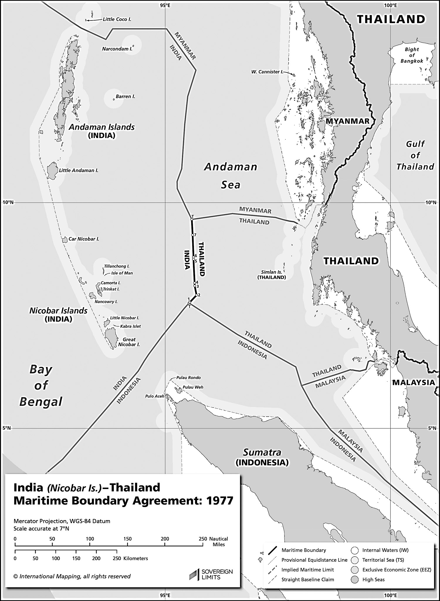
Figure: India Indonesia Maritime Boundary Agreement
INDIA-MALDIVES
• The maritime boundary between India and Maldives was established on 28 December 1976 and is a modified equidistance boundary. The total length of the boundary is 496.25 nautical miles.
• Eight Degree Channel: It separates the entire group of Lakshadweep Islands from the Maldives.
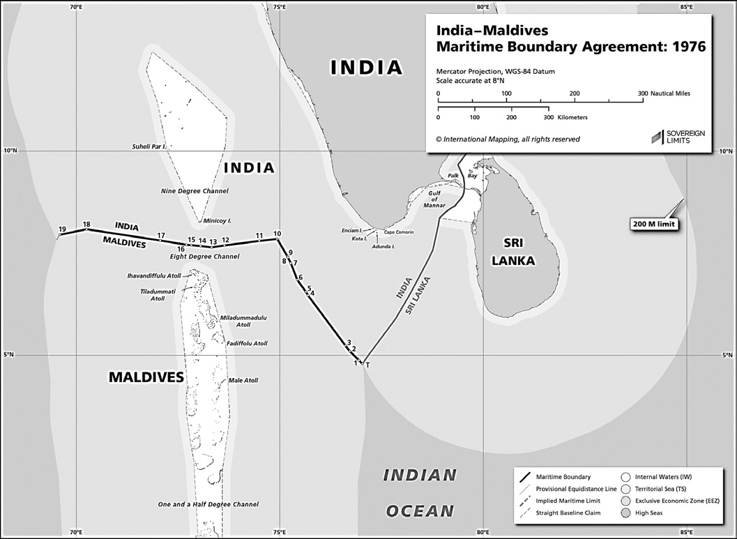
Figure: India-Maldives Maritime Boundary Agreement
• Threatens livelihood of the coastal populace.
• Impacts food and related economic security in India.
• Leads to border disputes e.g., India-Pakistan and India- Sri Lanka arresting fishermen from other’s jurisdiction.
As per the 2005 report of FAO (Food & Agriculture Organisation of UN) 75 per cent of fishery resources in south-western Indian Ocean
Non-traditional Threats
Non-Traditional Threats
Maritime Terrorism
Vulnerable maritime borders have been misused to attack civilian assets, including commercial centers, densely populated areas, transportation hubs, industrial zones,
ports, and ships, as well as key military targets, offshore oil facilities, and nuclear power plants.
In 1993, the explosives used in the Mumbai serial blasts were smuggled into India’s western coast using sea routes.
Similarly, the 26/11 attacks were executed by terrorists who gained entry through unguarded maritime borders.
Non-State Actors
These are threats because of evil criminal activities like environmental contamination, drug trafficking, illegal fishing, religious extremism and threat to national security because of terrorism.
Smuggling
• Limited Surveillance on the High Seas
• The high seas fall beyond the jurisdiction of any single nation or authority, leading to restricted monitoring capabilities.
• This gap is often exploited by non-state actors engaged in illicit activities such as trafficking and smuggling.
• Strategic Weaknesses
• Positioned between the **Golden Crescent** to the west and the **Golden Triangle** to the east, India faces persistent challenges due to unregulated maritime movements linked to drug and arms trafficking.
• Operational Tactics
• Traffickers and smugglers employ a method involving the transshipment of illegal consignments on the high seas onto smaller local vessels. These boats then blend in with fishing activities offshore, allowing them to discreetly land at numerous coastal entry points.
• The possibility of nuclear materials being smuggled into or out of neighboring countries further escalates the gravity of this issue.
• Piracy
• Piracy is one of the oldest maritime security threats, primarily targeting trade, thereby endangering a nation’s economy, risking the lives of crew members, and limiting the free use of sea routes for economic advancement.
• Over the past two decades, economic activities in the Indian Ocean Region (IOR) have surged due to the rising energy demands of China and India, as well as their expanding trade. This has attracted pirates to the region.
• In recent years, piracy originating from the Gulf of Aden and Somalia has extended into the Arabian Sea, reaching up to 500 nautical miles from India’s coastline.
• Decisive action by the Indian Navy and Coast Guard has effectively countered these threats, forcing pirates away from Indian waters.
• Since 2008, Indian naval ships have been patrolling the Gulf of Aden, escorting over 3,000 merchant vessels and safeguarding nearly 25,000 Indian and foreign seafarers.
• In 2015, the International Maritime organisation (IMO) modified the areas considered high-risk for piracy from
65 East to 78 east in the Arabian Sea.
• While the IMO took this step so that ships may be ready to take evasive action against Somali pirates, the resultant effect has led to ships hugging India’s territorial waters.
• Thus, vessels seeking to avoid waters that are at high risk of attacks of pirates impinge on the fishing zones of Indian fishermen. E.g., Enrica Lexie case where two Italian marines shot a fisherman from Kerala mistaking him for a pirate.
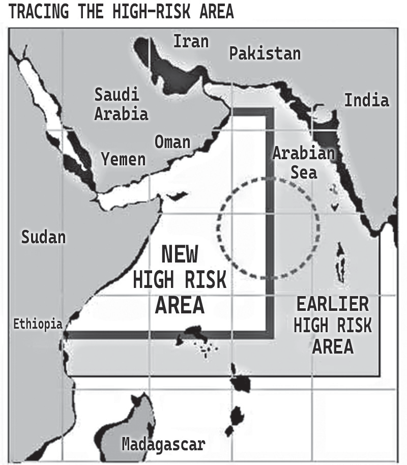
Figure: New and Old High Risk Area Limits
• Illegal, Unreported and Unregulated Fishing (IUU)
• IUU fishing undermines national and regional efforts to conserve and manage fish stocks and, as a consequence:
• Inhibits progress towards achieving the goals of long- term sustainability.
•
Threatens livelihood of the coastal populace.
• Impacts food and related economic security in India.
• Leads to border disputes e.g., India-Pakistan and India- Sri Lanka arresting fishermen from other’s jurisdiction.
• As per the 2005 report of FAO (Food & Agriculture Organisation of UN) 75 per cent of fishery resources in south-western Indian Ocean have been finished to their limits while the remaining 25 per cent have been harvested beyond ecological sustainment.
• As per United Nations Convention on the Law of the Sea (UNCLOS), coastal nations are responsible for addressing IUU fishing issues within their respective EEZ.
Climate Change
• Climate change has manifested in alteration of seasonal temperatures and weather patterns the world over. Because of the global surface warming, the Indian ocean sea level has risen up to 1.8 degree Celsius which is a 0.8 degree rise from the past century. Because of this, tiny, low-lying islands are at a threat of facing tidal storm surges and coastal erosion. The 2004 tsunami brought the National Disaster Management Center (NDMC). Its impact on maritime security include-
• Reduction of living resources leading to increased competition.
• Loss of national territory.
• Impacts on food, water and energy supplies.
• Natural disasters - tropical cyclones, tornadoes, floods, coastal and marine inundation, wave, tidal surge, coastal erosion, monsoon rain related flooding, high winds which endangers the flora and the infrastructures and climate change. These issues posed as a threat to the people who eventually had to leave the coastal areas for safer place to stay.
• These are impacts on living resources, possible inundation of low lying coastal areas and islands, the loss of national territory etc.
• Forced migration and displacement.
• Loss of livelihood.
Maritime Pollution
• Some of the causes for this is shipwrecks, collisions at sea and oil bunkering. These issues cause serious harm to the maritime ecosystem. Oil pollution is inevitable because of the constant use of ships. But, intentional discharge of toxic quantities of oil, trash, cargo, residues, etc. can be avoided. This would save the maritime ecosystem.
Drug Trafficking
• Because of drug trafficking and the smuggling of drugs into the countries illegally, many young people abuse and use drugs. In India alone, there are more than 2000 drug cases. This issue was difficult to counter because of the lack of resources to protect the borders. An example of a drug trafficking case is when officials discovered and confiscated more than a ton of hash oil concealed in the depth of 30m in the lagoon close to Dhiffushi island in 2006.
India’s Maritime Security Management
INDIA’S MARITIME SECURITY MANAGEMENT
India’s Coastal Vulnerability
Diverse topography – Includes creeks, bays, lagoons, estuaries, and backwaters which make surveillance difficult.
Long coastline- 7516kms.
Absence of Natural Barriers: Unlike land borders, the sea is open, fluid, and harder to regulate.
Focus on Maritime Security
It is only during the last two decades that some factors and incidences forced India to focus on its maritime security management.
• Opening of Economy in 1990: with increased trade vide sea, securing the shipping lanes became crucial.
• 26/11 Attack indicated the porosity of coastline, inadequacy in the surveillance of its maritime domain, and lack of co-ordination among various agencies playing role in maritime security.
• China’s Threat: with the ‘String of Pearls’ attempt to encircle India and make the Indian Ocean Region its stronghold.
Efforts to Reform India’s Maritime Security
• PM Modi’s Five Basic Principles for Maritime Security
• As to establish legitimate trade, free maritime trade sans barriers.
• Peaceful Settlement of maritime disputes and on the basis of international law only.
• Encourage responsible maritime connectivity.
• Maritime threats posed by non-state actors and natural calamities need to be collectively combatted.
Preserve maritime environment and maritime resources.
• Coastal Security Scheme (CSS)
The Department of Border Management is implementing the Coastal Security Scheme (CSS) in phases to enhance the infrastructure of police forces in coastal States and Union Territories. The scheme aims to improve patrolling and surveillance, particularly in shallow waters near the coastline.
•
Phase I of CSS, launched in 2005-06, resulted in the establishment of 73 Coastal Police Stations (CPS). Over a span of five years, these stations were equipped with 204 interceptor boats, 153 jeeps, and 312 motorcycles, ensuring better mobility along the coast and in nearby waters.
• CSS Phase II formulated post 26/11 and vulnerability/ gap analysis has been implemented from 2011 to 2020 for setting up CPS, marine operational centres, etc.
• Reforming Security Apparatus
• The Indian Navy, with support from the Indian Coast Guard and state maritime police, plays a key role in coastal security.
• To safeguard the coastline, the government has implemented a three-tier security mechanism.
• At the outermost level, the Indian Navy conducts patrols in the high seas and aerial reconnaissance using ship-based aircraft.
• The intermediate level, covering the Exclusive Economic Zone (between 12 and 200 nautical miles), is monitored by the Coast Guard.
• The areas near the coastline are patrolled by the Coastal Police.
• Joint Coastal Patrolling (JCP) by the Indian Coast Guard and Coastal Police began in 2020.
• The Indian Navy established Sagar Prahari Bal (Ocean Strike Unit) to protect naval bases and other strategic locations.
Sagar Suraksha Dal, an informal network of fishermen and trained coastal volunteers, assists in surveillance and intelligence gathering.
• Additionally, commando units of the Central Industrial Security Force (CISF) have been deployed across all ports.
• National Committee on Strengthening Maritime and Coastal Security (NCSMCS): to integrate all stakeholders- states and central agencies under the Cabinet Secretary.
• Commander In Chief of Coastal Police- is the Indian Navy Commander.
• Commander, Coastal Command- Is the Director General of Coast Guard who undertakes overall co- ordination.
• A unified command has been established for coastal districts to effectively counter terrorist threats originating from the sea.
• For island territories, the government has set up the Andaman & Nicobar Command (ANC), a joint command in the Andaman & Nicobar Islands that includes personnel from the Army, Navy, Air Force, and Coast Guard.
• Additionally, the Government of India has approved the establishment of the National Academy of Coastal
Policing (NACP) in Dwarka, Gujarat, to enhance coastal security training.
• 10 Coastal Police Stations notified by Ministry of Home Affairs for delaying with crimes committed in international waters i.e., beyond territorial waters and upto Exclusive Economic Zone (EEZ).
• Reforming Identification Systems
• Automatic Identification System (AIS) was made compulsory for all vessels above 20m.
• ReALCraft (Registration and Licensing of Fishing Craft) allows for easy identification of fishing vessels in Indian Waters.
• Issuance of biometric identity cards to the majority of fishermen has been done to enable biometric verification of the identity of fishing vessel crews at sea.
•
The National Maritime Domain Awareness (NMDA) project has been launched to enhance multi-agency coordination and reinforce ongoing initiatives aimed at strengthening maritime and coastal security.
• The National Command Control Communication Intelligence (NC3I) network is capable of monitoring 30,000 to 40,000 ships daily, ensuring comprehensive maritime surveillance.
• Alert suspicious movements.
• Track conventional and unconventional threats in IOR.
• Neutralise threats.
• Be the backbone for NDMA project.
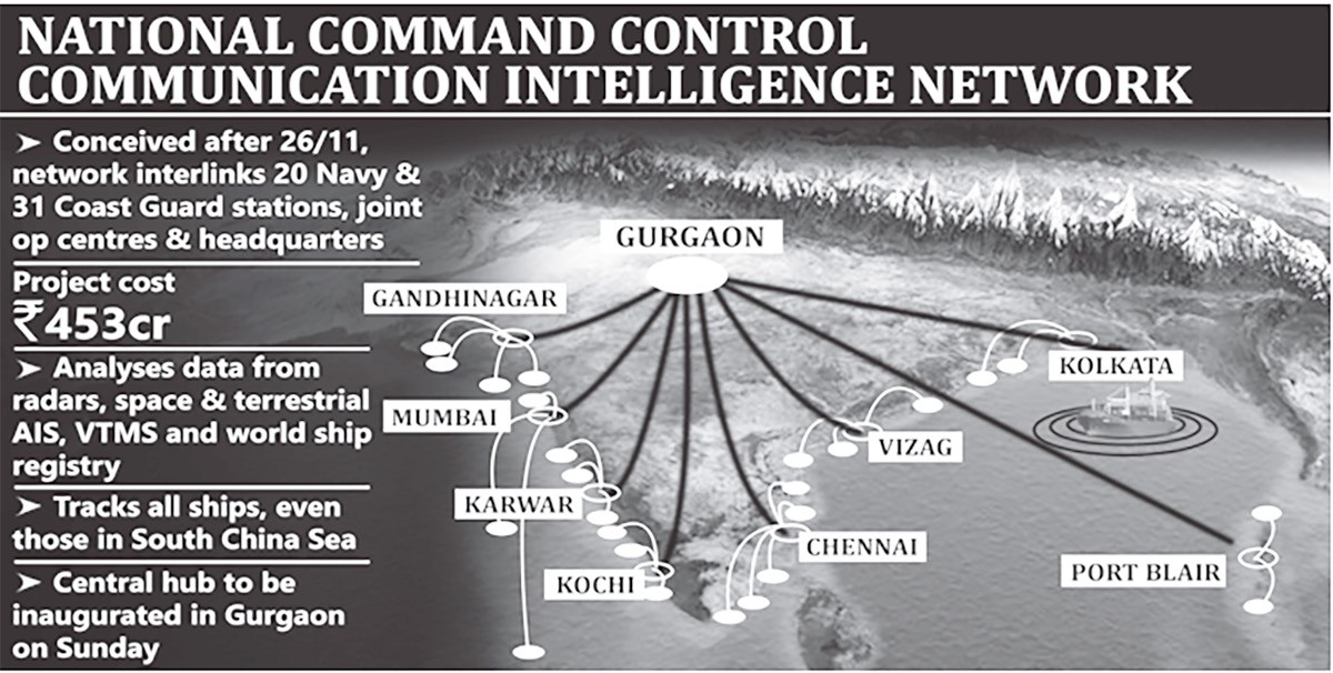
Figure: National Command Control Communication Intelligence Network
• Information Management and Analysis Centre (IMAC) at Gurgaon will fuse, correlate and analyse feeds and inputs from multiple sources ranging from coastal radars to satellites, to assess threats at sea.
• Undertaking International Collaboration
• India has consistently advocated a cooperative approach and the involvement of all nations in ensuring maritime security within the Indian Ocean Region (IOR), as outlined in the Prime Minister's vision of SAGAR – Security and Growth for All in the Region.
• The Indian Ocean Naval Symposium (IONS), established in 2008, is a voluntary initiative aimed at enhancing maritime collaboration among 36 navies of the Indian Ocean's littoral states.
• Bilateral and multilateral engagements, such as the
MILAN and MALABAR series of naval exercises, play a crucial role in countering illegal activities, including trafficking, arms smuggling, and other illicit maritime operations.
• Expediating governmental action -
• the coastal states/UTs have been directed to
• Expedite the implementation of the approved Coastal Security Scheme such as early completion of construction of coastal police stations, check
posts, out-posts etc.
• Immediately start coastal patrolling by locally hired fishing boats/trawlers.
• Carry out vulnerability/gap analysis on their coasts in consultation with Coast Guard.
• Make the 227 non-major ports compliant with
International Ship and Port Facility Security (ISPS) guidelines of Ministry of Shipping.
• To follow Single-Point Mooring (SPM) which is a loading buoy anchored offshore, that serves as a mooring point and interconnects for tankers loading or offloading gas or liquid products.
• To complete Coastal mapping which is a process of putting information on the map which includes vital details and location of Coastal Police Stations, local Police Stations, intelligence set up, fish landing points, fishing villages, Ports, Customs Check Posts, Hospital, Railway Stations, Bus Station, Bomb disposal facilities etc.
• Ministry of Shipping, Road Transport and Highways has been directed to Streamline the process of registration of all types of vessels, i.e., fishing as well as non-fishing vessels.
• Ministry of Forest Environment & Climate Change has been directed to Ease environmental norms for setting up coastal police stations
• Department of Animal Husbandry, Dairying and Fisheries has been directed to issue ID cards to all the fishermen and coastal population.
• Community Interaction Programs (ICP)
• Indian Coast Guard has been undertaking such programmes for the fishermen to bring in awareness about safety issues at sea.
Anti-Maritime Piracy Act, 2022
• Objective: To address piracy activities in both territorial waters and the high seas.
• Key Provisions:
• Definition of Piracy: The Act classifies piracy as any unlawful act of violence, detention, or destruction directed at a ship, aircraft, individual, or property on the high seas for private gain, committed by the crew or passengers of a private vessel or aircraft. It also criminalizes actions that incite, assist, or facilitate piracy.
• Punishments: The Act prescribes life imprisonment or the death penalty for those convicted of piracy.
• Authority for Arrest and Seizure: It grants designated officials the power to apprehend individuals and confiscate ships suspected of engaging in piracy.
• Establishment of a Special Court: A Special Court will be set up to handle cases related to piracy offenses.
• Extradition: Individuals accused of piracy can be handed over to another country for prosecution if India has an extradition treaty with that nation.
• Compliance with International Law: The Act aligns with global maritime piracy regulations, including the United Nations Convention on the Law of the Sea (UNCLOS).