Border Vs Frontier
INTRODUCTION •
Asmarkers of theterritorial sovereigntyof a state, borders perform interrelatedbut contradictory functions to protectthe state they enclose. On one hand, borders act asbarriers to undesirableelements such as goods, services, capital, people, and ideas considered harmful for thedomestic territory andpopulation.
Onthe other, they serve as bridges to facilitate legitimate socio-economic andcultural exchanges across countries. Traditionally, the primary role ofborders has been to prevent threats such as cross border terrorism, illegal migration, traffickingof narcotics and drugs, smuggling, etc.from entering the country and jeopardisingits security.
•The advent of a globalisedworld coupled with revolutions in mass communication and information technologies enabled an increase in crossborder movement. Free flow of people, goods, services, and capital across countries wasnecessary forthe growth ofthe globalisedmarkets. In thiscontext, the barrierwas seen as a hindrance to ‘free flow of trade, limiting the size of the market, and increasing transaction costs’, and therefore needed to be transformed into facilitators for greater economic integration through enhanced trade and connectivity. Consequently, borders acquired a new ‘bridging’ function.
Border vs Frontier
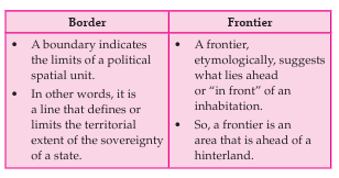
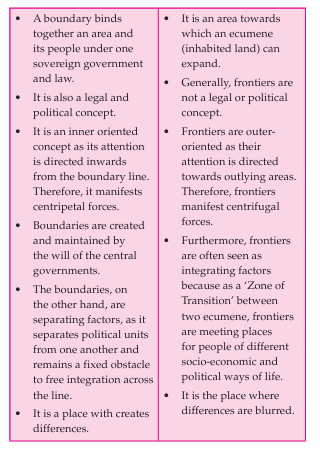
India’s International Borders
India’s International Borders
• As an sovereign independent country, India doesnot have frontiers.
• During themcolonialtimes, India had large areas,especially alongits north-western and north-eastern peripheries,which did not have defined boundaries.
• However, as British India extended its administration,delimiting the territorialextent of the empire these remote areas became necessary.
• Thus,in the northwest, the Durand Line was drawn in1893 to define the boundary between British India and Afghanistan.
• In the northeast, the McMahon Line was drawn in 1914 to delineate the territories between British India and Tibet.
• In 1954, the NEFT was renamed the North East Frontier Agency (NEFA). In 1972, NEFA was inaugurated as a Union Territory and renamed Arunachal Pradesh, which formally became India’s 24th state on 20 February 1987.
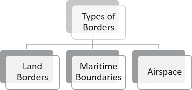
Land Border
It has well-defined land boundaries measuring 15,106.7 km with its seven land neighbours (Afghanistan, Pakistan, China, Nepal, Bhutan, Bangladesh, and Myanmar).
India shares over 15,000 kilometers of land boundary with her immediate neighbours:
• Bangladesh (4,096 km)
• China (3,488 km)
• Pakistan (3,323 km)
• Nepal (1,751 km)
• Myanmar (1,643 km)
• Bhutan (699 km)
• Afghanistan (106 km)
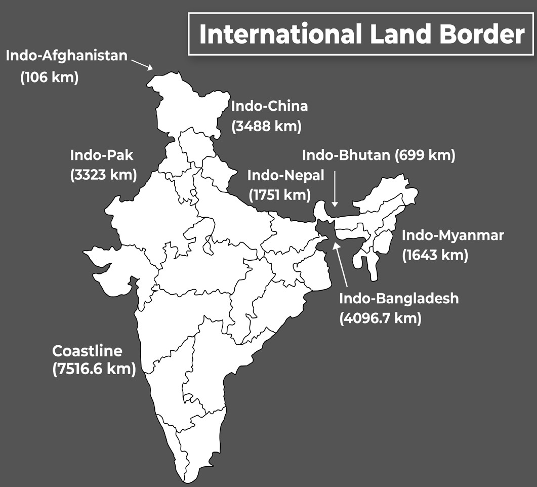
Figure: International Land and Maritime Borders of India
Demarcation of Maritime Boundary
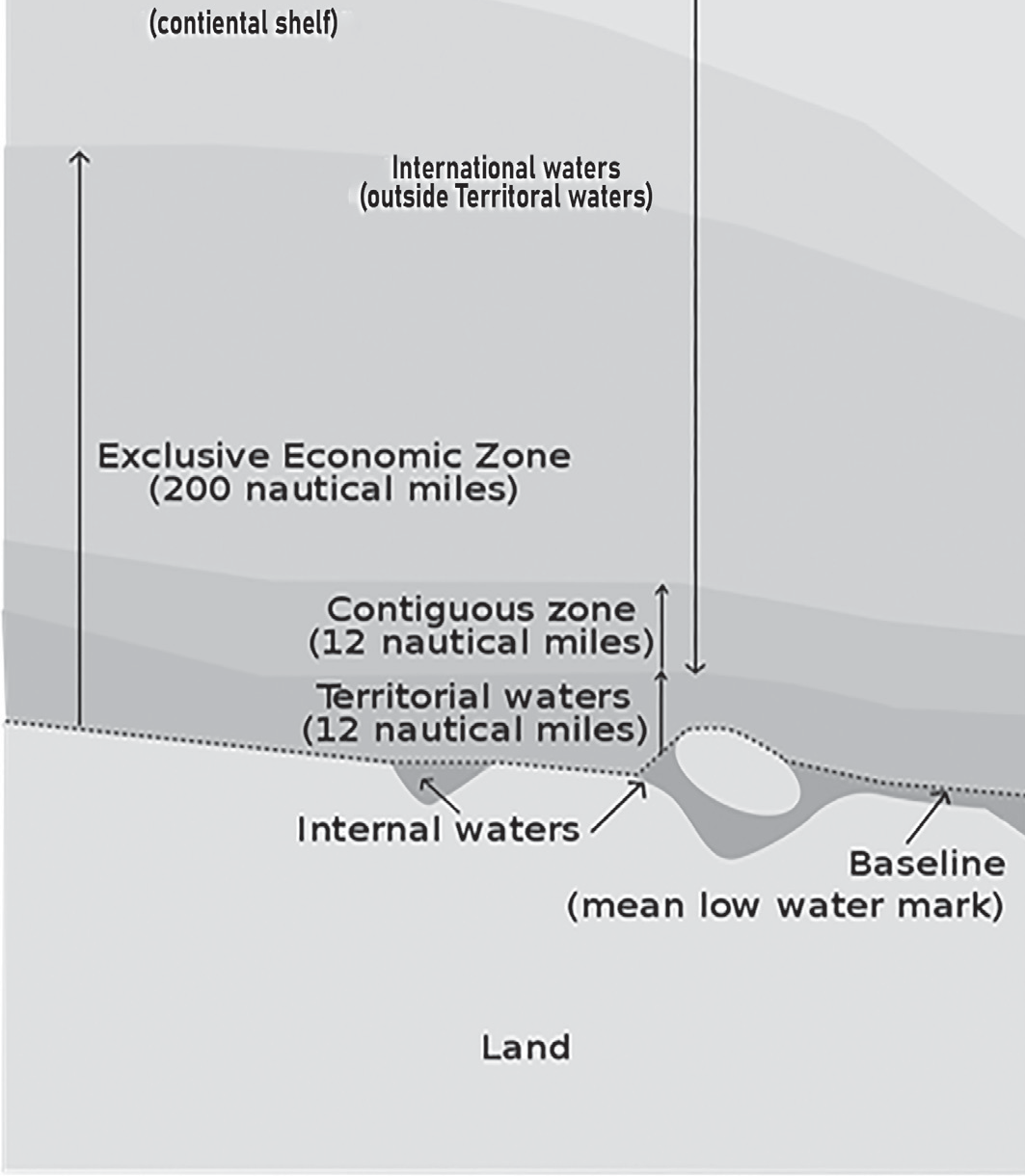
Figure: Maritime Boundary
India's Maritime Boundaries
• India, with its claim of a 12-nautical-mile (22 km; 14 mi) territorial maritime zone and 200-nautical-mile (370 km; 230 mi) Exclusive Economic Zone, has a more than 7,516-kilometre (4,300 mi) maritime border shared with seven nations.
• Delimitation is necessary with seven neighboring and opposite coastal states—Pakistan, Maldives, Sri Lanka, Indonesia, Thailand, Myanmar, and Bangladesh.
• Bangladesh and Pakistan share both land and maritime borders with India, whereas Sri Lanka has only a maritime border through Ram Setu.
• India's Andaman and Nicobar Islands share maritime borders with Thailand, Myanmar, and Indonesia.
• Territorial Waters vs International Waters
• The territorial waters and the exclusive economic zones shall also become part of the states or union territories without being separately mentioned in Schedule 1 and 4 of the constitution.
• The Territorial Waters, Continental Shelf, Exclusive Economic Zone and other Maritime Zones Act, 1976
was enacted by the Government of India to notify the sovereign rights on these areas for dealings with other countries.
Air Space
• Airspace is the portion of the atmosphere controlled by a country above its territory, including its territorial waters. It is not the same as Outer Space which is the expanse or space outside the Earth and Aerospace which is the general term for Earth's atmosphere and the outer space within the planet's vicinity.
• India’s Air Space Boundary
• Horizontally, the Indian air space is bound by the territory including territorial waters of the Union of India.
• Vertically, there are no defined limits. Owing to reduced air density with an increase in altitude, there are rarely any aircraft operations beyond 20 kilometers above mean sea level.
• Air Space Boundary
• According to international law, a state possesses full and exclusive sovereignty over the airspace above its territory. This principle aligns with the maritime definition of territorial waters, which extend 12 nautical miles (22.2 km) from a nation's coastline.
• Airspace not within any country's territorial limit is considered international, analogous to the "high seas" in maritime law.
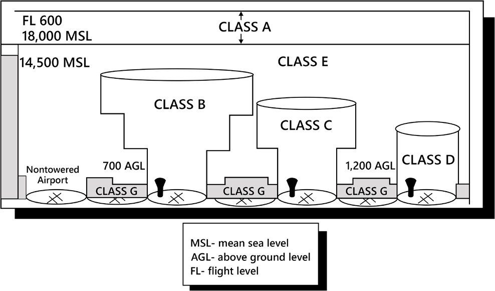
Figure: Air Space Boundaries
• Controlled Airspace: It exists where it is deemed necessary that air traffic control has some form of positive executive control over aircraft flying in that airspace (however, air traffic control does not necessarily control traffic operating under Visual Flight Rules (VFR) within this airspace).
Border Management
Border Management
In the early years after independence, persistence of various cross-borderthreats and challenges and an absence of robust intra-regional trade among its neighbouring countries forced India to employ a Security-Centric and Unilateral Approach to border management with emphasis on hardening the borders to cross-border trade and travel and keeping the border areas underdeveloped to act as a buffer against external conventional threats.
However, with India's economic growth and increasing confidence and resources, the country began viewing borders as connections rather than obstacles.
As a result, there was a stronger focus on developing border regions and re-establishing disrupted communication links with neighboring countries by investing in transportation infrastructure both along the borders and beyond.
India has actively engaged with its neighboring countries to enhance the management of its international borders. Several initiatives and programs have been introduced to strengthen border security and facilitate legitimate movement across borders. These include:
Establishing and reinforcing border security forces.
Constructing both physical and electronic barriers.
Setting up modern infrastructure to streamline legal cross-border travel.
Implementing special programs to develop border regions.
Enhancing trade and connectivity.
Establishing cooperative bilateral mechanisms for better coordination.
Border management refers to the comprehensive process of overseeing and regulating international borders. This encompasses security measures to prevent unauthorized crossings while ensuring smooth movement for legitimate travelers and goods with minimal disruption.
Effective border management requires a clear understanding of what qualifies as lawful and unlawful border crossings, distinguishing potential threats from legitimate movement. It also demands the strategic allocation of resources and well-planned policies to counter security risks while facilitating efficient clearance for authorized trade and travel.
Objectives of Border Management
According to the Ministry of Home Affairs (MHA) (2014), one of the primary goals of border management is to secure the nation's borders from entities that pose a threat while simultaneously ensuring systems are in
place to intercept such threats. At the same time, it aims to promote legitimate trade and commerce.
Border management encompasses the formulation of appropriate policies, legislative frameworks, administrative structures, and operational mechanisms. It also requires a well-equipped human resource system capable of addressing diverse challenges. Effective border management depends on seamless coordination among multiple agencies, including security forces, regulatory bodies, intelligence units, diplomatic channels, administrative departments, and economic entities.
• Core Objectives of Border Management
• National Security – Ensuring the protection of the country from external threats.
• Trade & Commerce – Facilitating smooth and legitimate economic exchanges.
• Sovereignty & Integrity – Upholding the nation’s sovereignty and territorial integrity.
Border Management Strategy
• Countries adopt various strategies for border management based on their threat perception and available resources.
• Some nations prefer to handle border management independently, while others collaborate with neighboring countries for better coordination.
• Certain countries focus primarily on security, reinforcing and tightening their borders to prevent threats. In contrast, some prioritize economic and social interaction by maintaining more open borders to encourage trade and cross-border engagement.
• India’s Border Management Strategy:
• India has traditionally focused on securing its borders due to various cross-border challenges such as insurgencies, militancy, terrorism, illegal migration, smuggling, and trafficking. This has led to restrictions on the unrestricted movement of people across borders.
• Additionally, the emphasis on a security-driven approach has been reinforced by the limited trade and economic exchanges with neighboring countries, which otherwise might have encouraged more open borders to facilitate smoother movement of goods and people.
• However, with significant economic growth in the 2000s, India witnessed a surge in trade and investment,
prompting a shift in its outlook towards neighboring and extended regions as economic partners.
• As India's economic focus evolves towards regional and global integration, borders are increasingly being viewed as facilitators of trade and movement rather than merely physical barriers.
This shift in perspective, coupled with rising trade with neighboring nations, has led India to implement programs aimed at the integrated and sustainable development of border areas. Increased investments and improved connectivity in these regions reflect a transformation in India’s border management strategy from a security-dominated and unilateral approach to one that prioritizes trade facilitation and cooperation
India’s Land Borders
INDIA’S LAND BORDERS
Indo–Pakistan Border
• Border Security Force (BSF) has the responsibility for the 3323 km long border with Pakistan.
• The Line of Control (LoC): It is a military control line between the Indian- and Pakistani-controlled parts of the former princely state of Jammu and Kashmir—a line which does not constitute a legally recognized international boundary, but serves as the de facto border, earlier called Ceasefire Line. It was established as part of the Shimla Agreement at the end of the Indo-Pakistani War of 1971.
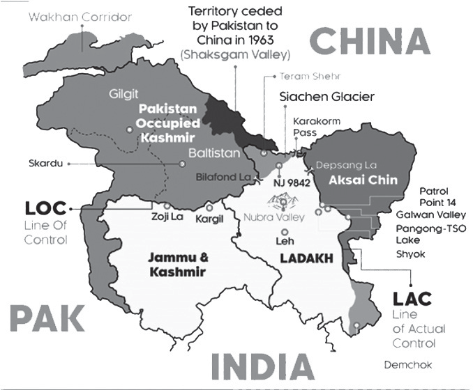
Figure: Indo-Pak Border
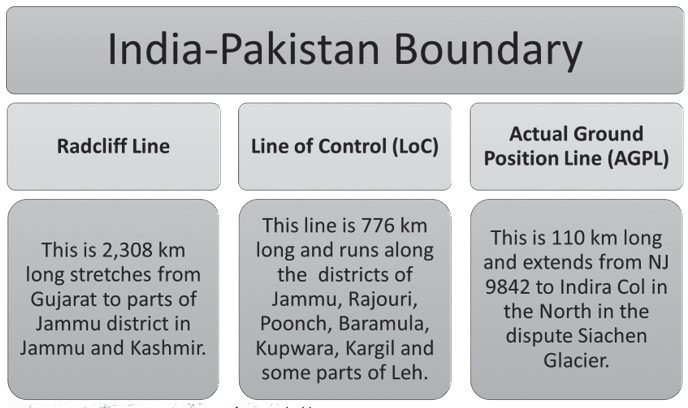
Figure: India-Pakistan Boundary
• Sir Creek Estuary in Gujarat:
• Sir Creek is a 96 km estuary that lies between Kutch in Gujarat and Pakistan’s Sindh province. But it is also a disputed land.
• India claims the boundary should lie in the middle of the creek. Pakistan claims the boundary should lie in the eastern bank, closer to India. The fishermen of Sir Creek are often caught in this crossfire.
• The Indian military Border Security Force (BSF) patrols Sir Creek up to midstream using floating border posts, amphibious vehicles, and foot travel by the Creek Crocodile Commandos. The coastal area of Sir Creek is manned by the Indian Coast Guard, and the larger open sea beyond is patrolled by the Indian Navy.
• Challenges of Indo- Pakistan Border (IPB)
• Use of Unmanned Aerial Vehicles (UAV): For India, the increased use of UAVs like mini and micro drones by smuggling syndicates and terrorist groups on the western border has emerged as a new challenge for national security. For example, attack on the Air Force base in Jammu by Lashkar-e-Taiba in 2021 demonstrated for the first time the use of drones for terrorist attacks.
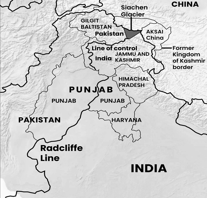
Figure: Radcliffe Line
•
Insufficient Resources: Inadequate manpower, lack of resources and inadequate cooperation from Pakistan make management of the border difficult.
• Porous Border Across Diverse Terrain: The India- Pakistan boundary runs through diverse terrain like deserts, marshes, plains and snow-clad mountains, and winds its way through villages, houses and agricultural lands, making it extremely porous. This is exploited by Pakistan based criminals for drug trafficking:
• Throwing packets of contraband over the fence across the border by involving the border population, who are ideal couriers as they are well-versed with the topography and local environment;
• Using 10-12-meter-long plastic pipes to move the drugs (packed in small packets) across the border while dodging the electrified fence;
• Making cavities inside farming vehicles and appliances as these are allowed to cross the fence for farming activities.
• Illegal Activities: The porous nature of this border has enabled various unlawful activities, including smuggling, drug and arms trafficking, and infiltration.
• Smuggling: The primary contraband items smuggled across this border include heroin and counterfeit Indian currency. Additionally, goods such as saffron, textiles, and mercury are illegally transported from Pakistan.
• Money Laundering: Punjab, particularly Ludhiana, has become a hub for a widespread hawala network facilitating large-scale money laundering.
• Illegal Fishing: The challenging terrain of the Sir Creek area makes it difficult for border security forces to operate effectively, creating opportunities for illegal fishing in the creeks.
• Propaganda: The border population has also been exposed to hostile propaganda from Pakistan, aimed at misleading and influencing their allegiances.
• Wars: A strained political relationship, multiple wars, and Pakistan’s support for secessionist militants in Punjab and Jammu & Kashmir have compelled India to reinforce its international border with Pakistan.
• Balancing Security & Trade: Consequently, India faces the ongoing challenge of maintaining the border as a strong defense against cross-border terrorism while
simultaneously ensuring it remains open for controlled trade and travel.
Tackling Border Challenges:
• Ministry of Home Affairs in its Annual Report 2021-22 outlined the following measures taken to strengthen the border-
• The Government of India, in collaboration with State Governments, has implemented a comprehensive strategy to curb cross-border infiltration. This approach includes enhancing border management, deploying security forces in multiple layers along the International Border, closely monitoring infiltration routes, constructing border fencing, and addressing gaps using advanced technological solutions. Additionally, security forces are equipped with modern weapons and equipment, while intelligence gathering and operational coordination have been significantly improved.
• ‘National Counter Rogue Drone Guidelines’ 2019: Ministry of Civil Aviation has issued these guidelines and highlighted the subversive use of drones for surveillance and reconnaissance of sensitive defence installations, airspace interference, smuggling, and kinetic attacks.
• Counter-UAV Efforts: At the border, security agencies are employing various counter-UAV systems. These include the system that can detect, identify and neutralise different types of drones, including Small Hybrid UAVs, Micro UAV/Multirotor, and Nano UAVs. A typical counter-drone system comprises the following elements:
• Drone detection and tracking radar
• Day and night camera with laser ranging for detection and tracking of a drone target
• Communication channel detection and jamming system (soft kill)
• GPS jamming/spoofing system (soft kill)
• Laser-directed energy weapon system (hard kill).
• Improving Infrastructure:
• 731 Border Out Posts, 2000 kms of floodlights, 2000km of fence setup to curb infiltration, cross-border crimes, smuggling etc.
• Laser Walls is one of the integrated measures taken by BSF, to cover the unfenced riverine stretches.
• Integrated Check Post (ICP) Border crossings with designated Integrated Check Posts (ICP) with immigration and customs facilities are:
•
Attari and Wagah is the most famous and prominent border crossing point between India and Pakistan due to the Attari–Wagah border ceremony. The crossing is located 32 kilometres from Amritsar and 24 kilometers from Lahore.
• Munabao: This village situated at Barmer district in Rajasthan, is famous for the railway station through which, the Thar Express connecting India with Pakistan runs. The crossing point had been closed after the Indo-Pakistani War of 1965. In February 2006 it was reopened and since then the Thar Express operates from Bhagat Ki Kothi in Jodhpur, India to Karachi, Pakistan.
• Other crossings
Ganda Singh Wala border: Kasur (Pakistan)- Hussainiwala(India).
Sulaimanki, Punjab (Pakistan side) / Fazilka border, Okara District (India side).
Longewala (closed).
• Connectivity:
• Bus Links: Delhi–Lahore Bus, officially known as Sada-e-Sarhad is a passenger bus service connecting the Indian capital of New Delhi, Delhi with the city of Lahore, started in 1999 (stopped since 2019), via the border transit post at Wagah near Attari.
• Train Links: The Samjhauta Express (Delhi-Lahore) was a twice-weekly train, Thursday and Monday, that recently ran only between Attari in India and Wagah in Pakistan. It started in 1976 after Simla Agreement (stopped since 2019). The word Samjhauta means "agreement", "accord" and "compromise" in both Hindi and Urdu.
• Comprehensive Integrated Border Management System (CIBMS) along Indo-Pakistan Border (IPB)
• The Comprehensive Integrated Border Management System (CIBMS) combines manpower, sensors, networks, intelligence, and command control solutions to enhance situational awareness across different levels of authority, enabling swift and effective responses to emerging threats.
• Technological Solutions: The Border Security Force (BSF) has conducted a detailed study of the Indo- Pakistan border, assessing vulnerabilities, terrain conditions, crime patterns, and unique regional characteristics. Based on this analysis, the border has been segmented and secured using advanced technological solutions.
As part of this initiative, two pilot projects
covering 5 km each have been implemented along the International Border (IB) in Jammu.
Electronic Surveillance: Further, a proposal of electronic surveillance of vulnerable patches has also been approved.
Indo-Bangladesh Border
• India has the longest shared border with Bangladesh, spanning 4,096 km.
• This border, referred to as the Zero Line or Radcliffe Line, is governed by the Indira-Mujib Pact of 1972, which prohibits the construction of any permanent structures within 150 yards of the boundary.
• The Indian side of the Indo-Bangladesh border passes through
• West Bengal (2216.7 km)
• Assam (263 km)
• Meghalaya (443 km)
• Tripura (856 km)
• Mizoram (318 km)
• The entire stretch consists of plains, riverine belts, hills & jungles. The area is heavily populated and is cultivated right up to the border.
• The boundary was drawn by ‘Bengal Boundary Commission’.
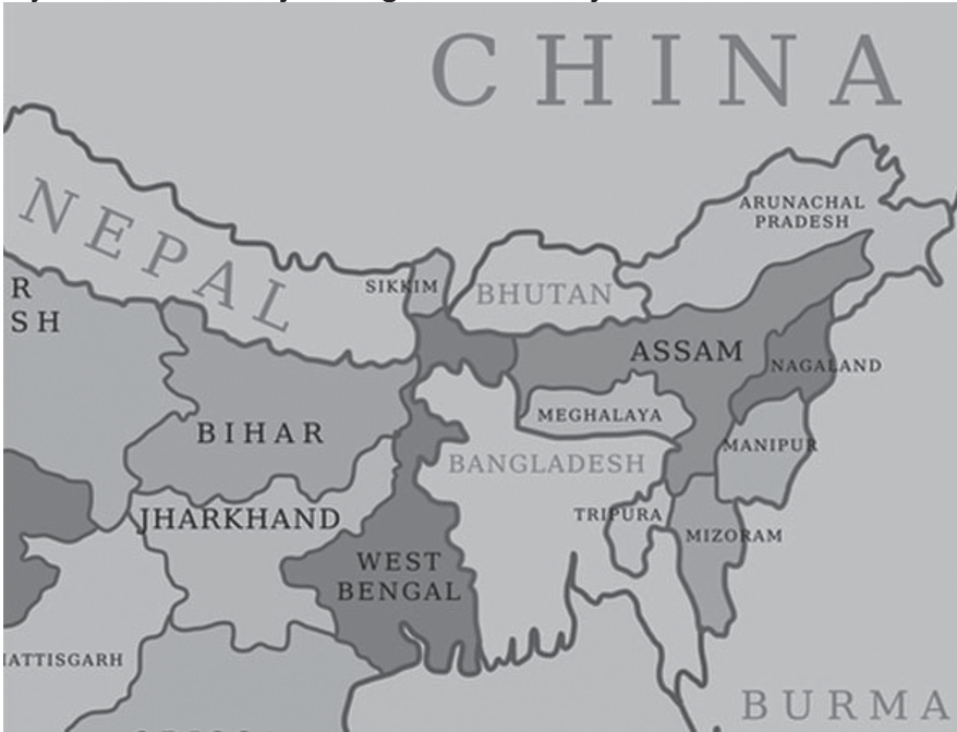
Indo-Bangladesh Border (IBB) Challenges
• Land Disputes: Instead of aligning with natural barriers, the border winds through villages, farmlands, and rivers, making it highly porous and leading to multiple contested areas.
Issue of Enclaves: The presence of unmarked border sections, enclaves (chhitmohols), and adverse possessions has been a continuous source of tension between the border security forces of India and Bangladesh.
• Illegal Migration: The movement of undocumented migrants from Bangladesh to India has persisted since independence.
• Several "push factors" contribute to this trend, including poverty, political instability, religious persecution, population pressures, and environmental challenges.
• On the other hand, "pull factors" such as access to land, job prospects, healthcare, and education attract migrants to India.
• Trans-Border Crimes: Porous border, lack of economic opportunities, poverty and underdevelopment, attitude of the people towards petty crimes, laxity in vigilance, alleged nexus between criminals and police and border guarding forces all contribute to the escalating trans- border crimes, kidnapping, and thefts are quite common along this border.
• Insurgents Escape & Infiltrate: The porosity of the border also allows Indian insurgents to cross over to Bangladesh and other neighbouring countries for asylum.
• Smuggling has become a serious concern.
Cattle: Truckloads of cattle from Haryana, Rajasthan, Uttar Pradesh and Madhya Pradesh are shipped to the India-Bangladesh border every day, ostensibly for grazing purposes. The Border Security Force (BSF) regularly seizes cattle.
Arms, Narcotics, Goods: Along with cattle, smuggling of arms and other essential items, such as sugar, salt and diesel, human and narcotics trafficking, counterfeit Indian currency.
Tackling Border Challenges
• Ministry of Home Affairs in its Annual Report 2021-22 outlined the following measures taken to strengthen the border-
• Improving Infrastructure: To curb infiltration, cross- border crimes, smuggling etc.
1078 Border Out Posts (BOPs) are the main workstations of the BSF along the borders. These are self-contained defence out-posts with a specified
area of responsibility established along the entire continuum of land borders. Inter-alia, the BOPs are meant to provide appropriate show of force to deter trans-border criminals, infiltrators and the hostile elements from indulging in the activities of intrusion/ encroachment and border violations. Each BOP is provided with the necessary infrastructure for accommodation, logistic support and combat functions.
Designated Integrated Check Posts (ICP), with both customs and immigration facilities and Land Customs Stations (LCS) are:
Assam
Mankachar Land Customs Stations (India) and Rowmari post (Bangladesh)
Karimganj–Beanibazar Upazila via Sutarkandi integrated checkpost crossing on NH37(India) and Sheola post (Bangladesh)
Karimganj Steamer and Ferry Station (KSFS) Land Customs Stations (India) and Zakiganj post (Bangladesh)
West Bengal
Kolkata–Dhakavia Petrapole-Benapole integrated checkpost crossing
Malda–Rajshahi via Mahadipur crossing
Changrabandha integrated checkpost
Hili
Meghalaya
Bagmara Land Customs Stations (India) and Bijoyour post (Bangladesh)
Borsara Land Customs Stations (India) and Borsara post (Bangladesh)
West Garo Hills–Bakshiganj via Mahendraganj crossing on NH12
Tura–Nalitabari via Dalu crossing on NH217 (India) and Nakugaon post (Bangladesh)
Shillong–Sylhet via Dawki integrated checkpost crossing (India) and Tamabil post (Bangladesh)
Tripura
Agartala–Dhaka via Agartala integrated checkpost (India) and Akhaura checkpost crossing
Santirbazar–Feni via Santirbazar integrated border checkpost road and railway crossing in South Tripura district
Mizoram
Kawarpuchiah integrated checkpost, opened in
October 2017 by Prime Minister Narendra Modi.
• Fencing: The total length of the Indo- Bangladesh border is 4096.7 km of which 3145 km has been covered by physical fencing and remaining about
951.70 km will be covered by physical and non- physical barriers. The non-physical barrier will comprise of technological solutions. Sanction has also been accorded to replace old design fence with a new design fence.
Challenges: There have been some problems in the construction of fencing in certain stretches on this border due to riverine/low lying areas, habitations within 150 yards of the border, pending land acquisition cases and protests by the border population, which delay the completion of the project.
• Floodlighting: over 3000km of flood lighting has been sanctioned.
• Connectivity:
• Bus Links: The Kolkata–Dhaka Bus started in 1999. In 2001, another bus service was launched to connect Dhaka with Agartala. In 2015, direct bus service from Kolkata to Agartala via, Petrapole, Dhaka, Akhoura began.
• Rail Links: Two scheduled passenger trains run between Kolkata and Bangladesh as the Maitree Express and the Bandhan Express. One train Mitali Express runs between Dhaka Cantonment and New Jalpaiguri Junction of North Bengal.
• Roads: Roads are being constructed for improved communication and operations mobility. Over 4200kms of roads have been sanctioned.
• Border Security Force (BSF) is India's border guarding organisation on its border with Pakistan and Bangladesh.
• Comprehensive Integrated Border Management System (CIBMS) along India Bangladesh Border.
• CIBMS is the integration of manpower, sensors, networks, intelligence and command control solutions to improve situational awareness at different levels of hierarchy to facilitate prompt and quick response to emerging situations.
• Technological Solutions: BSF has studied the Indo- Bangladesh border and based on the vulnerability, terrain conditions, crime pattern and peculiarity of area, the border has been classified into different segments to cover through technological solutions.
• Electronic Surveillance: Further, a proposal of electronic surveillance of vulnerable patches has also been approved.
IBB LAND BOUNDARY AGREEMENT (LBA), 2015
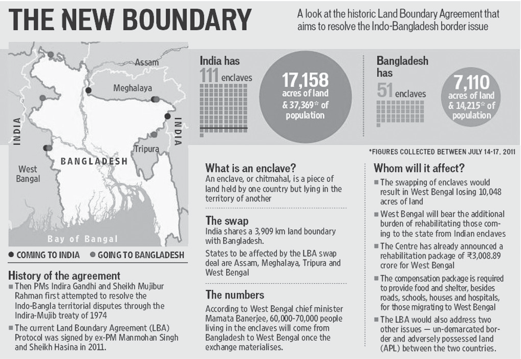
Figure: IBB Land Boundary Agreement (LBA), 2015
Enclave: is piece of land held by one country but lying in the territory of another country.
Problem of Enclaves: They did not allow government to establish administrative set-up to provide facilities like police stations, courts, schools, roads, hospitals, banks, markets, etc. for the residents.
• The 2015 LBA was signed on 6 June 2015 in Bangladesh. The historic agreement facilitated the transfer of 111 enclaves, adding up to approximately 17,100 acres, from India to Bangladesh. Conversely, India received 51 enclaves, adding up to 7,110 acres, which were in Bangladesh.
• The 100th Amendment to the Indian Constitution was passed in 2015 to bring into effect this land swap.
• Choice of Country: Under the agreement, the enclave residents could continue to reside at their present location or move to the country of their choice.
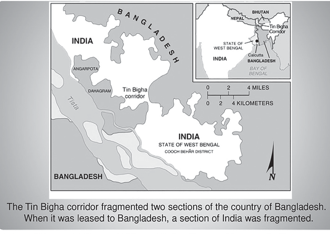
Figure: India: The Tin Bigha Corridor
• The Tin Bigha Corridor is a strip of land belonging to India on the West Bengal–Bangladesh border which, in September 2011, was leased to Bangladesh so the country could access its Dahagram–Angarpota enclave from the mainland. The enclave remains the only one still in existence after the 2015 resolution of the India-Bangladesh enclave’s issue.
Indo-China Border
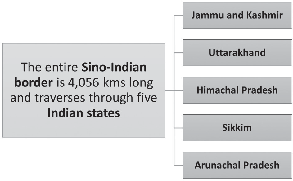
Figure: States sharing boundaries with China
• India's International Border (IB) with China is 4,056 km. The length given by the Ministry of Home Affairs
(MHA) is 3,488 km which is the length of the Line of Actual Control (LAC).
• On the Chinese side, the line traverses the Tibet Autonomous Region.
• The border between China and India has never been officially delimited. Not a single Chinese government recognised the McMahon Line.
• Line of Actual Control (LAC)
• Another ceasefire line separates the Indian-controlled state of Jammu and Kashmir from the Chinese- controlled area known as Aksai Chin. Lying further to the east, it is known as the Line of Actual Control (LAC). This demarcation existed as the informal Ceasefire Line between India and China after the 1962 conflict until 1993, when its existence was officially accepted as the ‘Line of Actual Control’ in Border Peace and Tranquility Agreement signed in 1993.
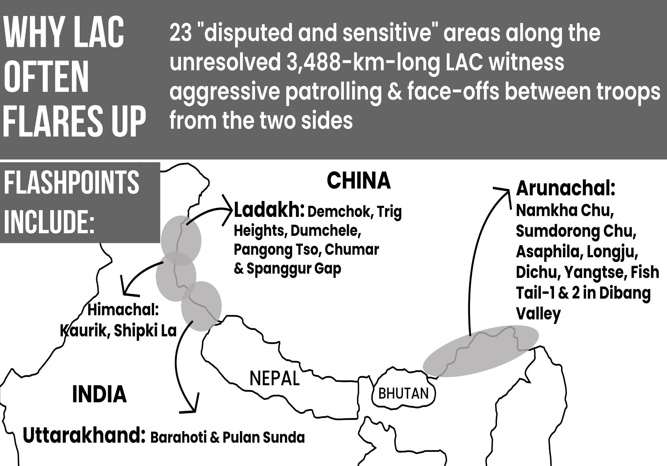
Figure: Western Sector of India China Border
• India perceives the ongoing border clashes with China as a significant security threat. Since the 1962 war, both countries have consistently strengthened their military and logistical infrastructure in the contested areas.
Chinese Occupation of Indian Territory
Figure: Central Sector of India China Border
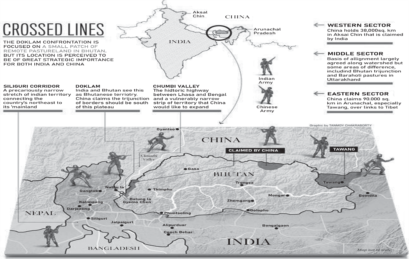
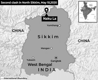
Figure: Clash at Naku La in North Sikkim\
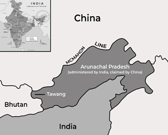
Figure: Eastern Sector of India China Border
| Occupied or Claimed Areas | Disputes |
| Western Sector China occupies approximately 38,000 square kilometers of Indian territory known as Aksai Chin, located in the Union Territory of Ladakh. Additionally, under the 1963 China-Pakistan "Boundary Agreement," Pakistan transferred 5,180 square kilometers of Indian land in Pakistan-Occupied Kashmir, known as the Shaksgam Valley, to China. China has maintained its control over the Aksai Chin region, where it constructed a strategic highway connecting the Xinjiang and Xizang autonomous regions. | Galwan Valley, Pangong Tso (lake), Gogra-Hot Springs (2020) |
| Middle Sector China claims about 2000 sq. kms. in the Middle Sector. | |
| Eastern Sector China claims approximately 90,000 sq. kms. of Indian territory in Arunachal Pradesh. It is flat and rich in water and forest resources. The area of this disputed region is three times that of Taiwan, six times that of Beijing. It borders China’s Xizang Autonomous Region. | Doklam Standoff (2017) Naku La (2020) Tawang (2022) |
Recent Skirmishes
• Tawang (2022):
• Encounter started when Chinese troops "encroached into Indian territory" and "unilaterally tried to change the status quo" along the disputed border near the Yangtse area.
• Standoff between India and China (2020):
•
Starting in April 2020, Chinese troops and armaments were assembling along the in eastern Ladakh leading to stand-offs and skirmishes at Galwan Valley, Pangong Tso (lake), Gogra-Hot Springs and other areas.
• The People’s Liberation Army (PLA) moved into Indian territory and built fortified structures and defences, changing the status quo on the ground.
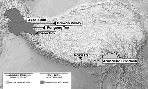
Figure: Indian lands claimed by China and Pakistan
• Naku La 2020
• On May 9, 2020, clashes occurred.
• Pangong Tso 2020
• On May 5, 2020- PLA troops moved up to Finger 4 from Finger 8, and then a major clash occurred which resulted in injuries to over 70 Indian soldiers.
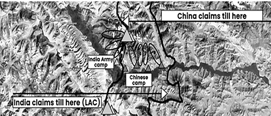
Figure: Indian and Chinese Claims
•
Fingers in the lake: The barren mountains on the lake’s northern bank, are called “fingers” by the Army.
• Pangong Lake of Ladakh, the world's highest saltwater lake, two-thirds of which lies in China.
• The Indian Army has a permanent position near Finger 3, while the Chinese have a base east of Finger 8.
• India holds one-third of the 135 km-long boomerang- shaped Pangong lake.
Galwan Valley 2020
• The Galwan River flows from the disputed Aksai Chin area. Originates in the Karakoram range and joins Shyok river (tributary of Indus) at Daulat Beg Lodi.
• Construction was being undertaken by China of roads to Galwan valley, however when India in response started construction as well, Chinese opposed.
| Finger 2 | Finger 4 | Finger 8 | |
| China’s Stand | China believes that the LAC passes through Finger 2. | Chinese use light vehicles on the road to patrol up to Finger 4. | Chinese border posts are at Finger 8. |
| India’s Stand | Indian’s troops confront Chinese troops while patrolling here. | India physically controls area only up to Finger 4. | India claims that the LAC is coterminous with Finger 8. |
• On 16 June 2020, China attempted to advance further in the valley through troop movement and road construction.
• Twenty Indian soldiers were killed. China occupied Patrol Point 14 and moved 1 km into the Indian territory.
• The Doklam Standoff 2017
• In Doklam area of Bhutan, a faceoff between India & China ensued when Chinese Army entered the area to construct a road in Southern Doklam. India’s physically stopped any Chinese construction.
• Doklam is an area spread over less than a 100 sq km comprising a plateau and a valley at the trijunction
between India, Bhutan and China. It is surrounded by the Chumbi Valley of Tibet, Bhutan’s Ha Valley and Sikkim.
• What lies at the heart of the Doklam dispute?
• China argues that the India-China-Bhutan trijunction is at Mount Gipmochi (Gyemo Chen), which is far south of where India and Bhutan mark the trijunction, near Batang la.
• China’s ire is aimed not at Bhutan, but at India’s ‘interference’.
• One reason for this is China's view that, by crossing over into Bhutanese territory at Doka la, India had 'trespassed' the agreed-upon Sikkim-Tibet border and entered Chinese territory.
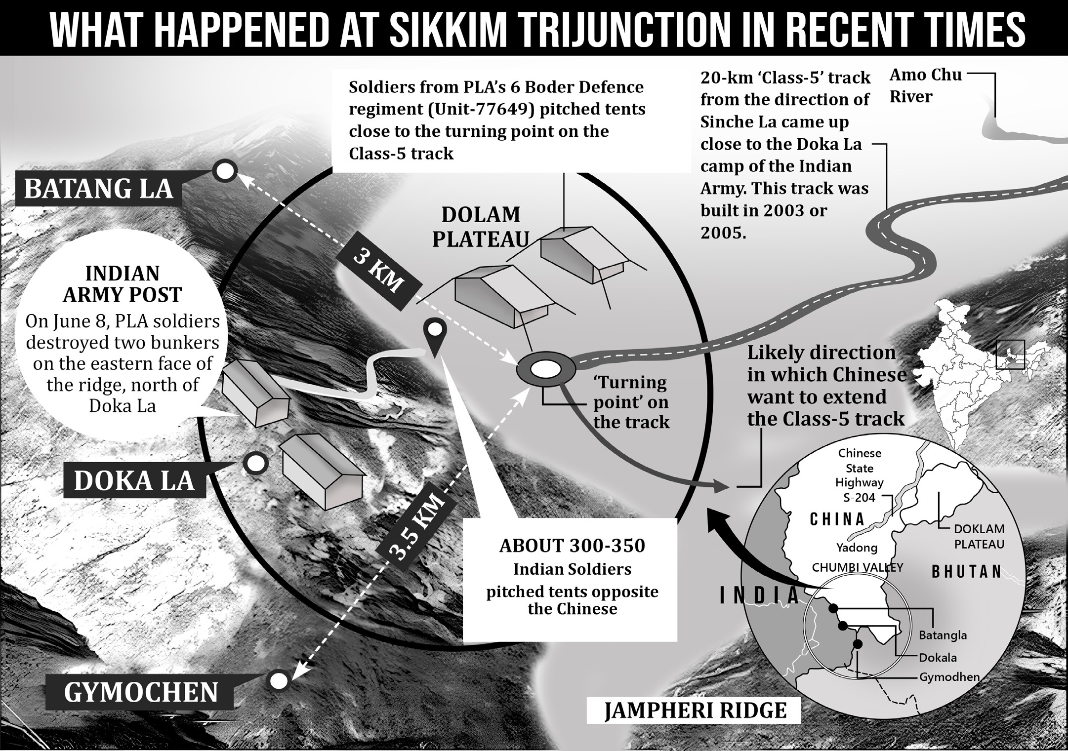
Figure: India’s Concerns on Doklam
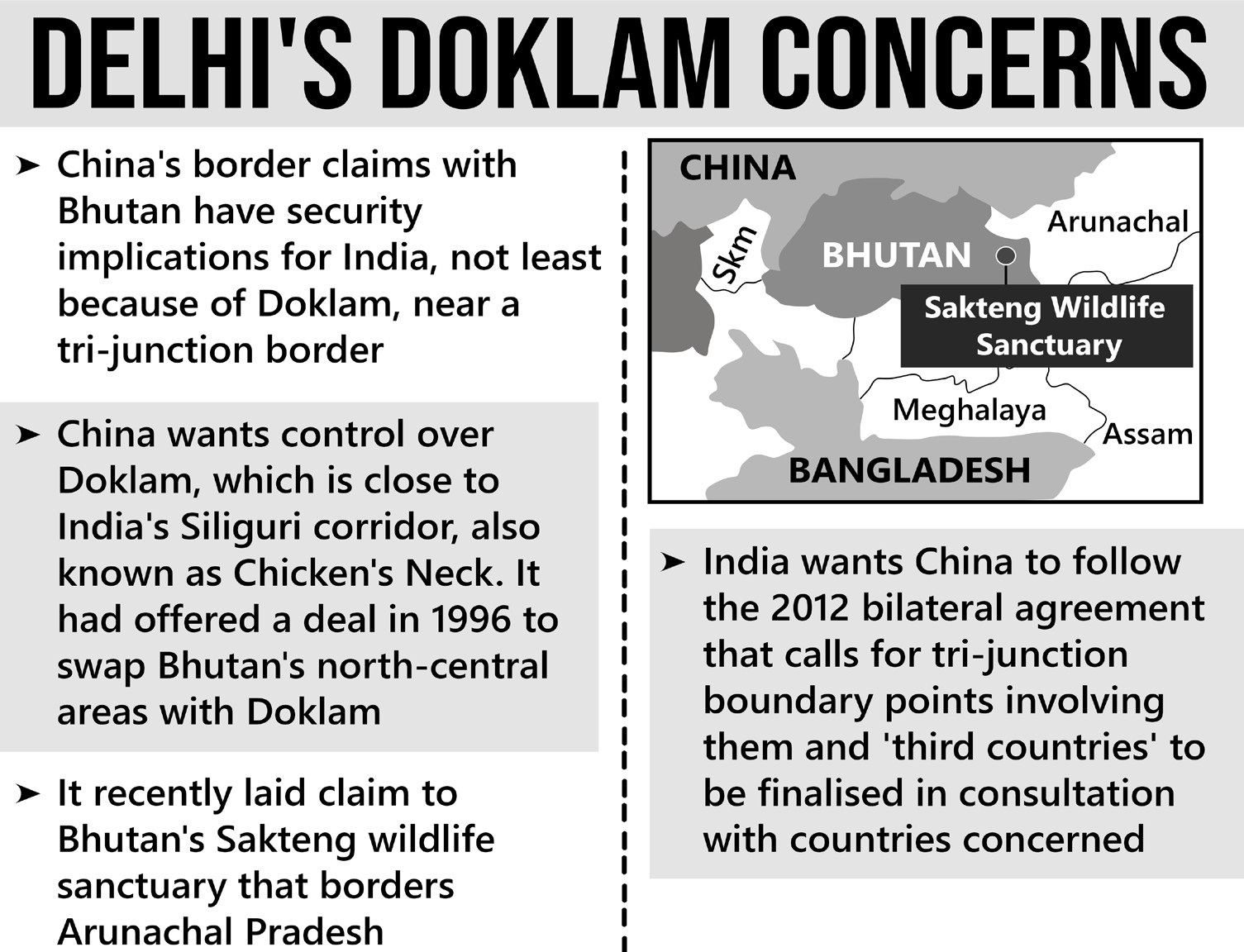
Figure: India’s Concerns on Doklam
Challenges for Indo-China Border Management
• China’s Aggressive Moves: Most of the countries are criticizing China for its expansionist policies and aggression that is being displayed by it e.g., in South China Sea, takeover of Hong Kong etc.
• With China's deepening alliance with Pakistan, including massive investments in PoK, the view in New Delhi is that India is now dealing with a fundamentally different China-one that is less cautious, more muscular and not afraid to aggressively pursue its interests overseas.
• Trade and Cyber Assaults by China:
• The International support that India has received has been a great sign. Even though any physical war would not be beneficial for any country but then also countries are preparing themselves for other types of war including Trade war, Cyber war etc.
• India in this context had banned fifty-nine of Chinese popular applications in India over security concerns.
• Even Government and people of India are boycotting Chinese goods.
• Strategic Advantage:
• At the LAC front, Chinese are placed at a strategically better position than India and also, they are more war-ready than India at present.
• More Resources & Preparedness:
• They have built roads till the LAC and are patrolling on vehicles while Indian troops still patrol on foot.
• China-Pakistan Economic Corridor (CPEC): It is an infrastructure and economic development project that aims to connect Gwadar Port in southwestern Pakistan to China's northwestern region of Xinjiang. India has following concerns with this project
• Sovereignty & Territorial Integrity- CPEC passes through PoK a region that India claims as its own
• Security Concerns: Infrastructure development may have military applications.
• China-Pakistan Nexus: India perceives CPEC as strengthening the strategic and economic relationship between China and Pakistan, which it views as a potential security threat.
• Geopolitical Rivalry: India and China have had longstanding geopolitical rivalries, and their competition for influence in South Asia adds to the tensions surrounding CPEC.
Lack of Transparency: India has also criticized the lack of transparency and consultation in the planning and execution of CPEC projects. It has raised concerns about the debt burden on Pakistan and the potential for exploitative economic practices.
• Unfortunately, we in India have not come out of the habit of working in ministerial silos and stovepipes which in the past have often resulted in military operations not achieving the desired strategic goals.
• Unlike western democratic nations, our ministers and civil officials are still shy of involving military personnel directly in defence policy-making or while negotiating such issues with foreign political leaders.
Steps Taken
• Diplomatic Engagement
• The Agreement on the Maintenance of Peace and Tranquility: It was signed in 1993, which called for a renunciation of the use of force, recognition of the LAC, and the resolution of the border issue through negotiations.
• The Agreement on Confidence Building Measures in the Military Field along the LAC: It was signed in 1996, which laid down pledges on non-aggression, prior notification of large troop movements, and exchange of maps to resolve disagreements over the LAC.
• The Border Defence Co-operation Agreement: It was signed in 2013 following the Depsang Valley incident.
• Meanwhile, International diplomacy is required so that international pressure is increased on China to back off and stop its expansionist designs.
• Military Deployment:
• We have to increase our military deployment to match the Chinese and find solutions for the challenging terrain.
• The Indian Army, on its part, has deployed a whole host of artillery weapons along the LAC, which range from the old 155mm Bofors and new M-777 ultralight howitzers and `winterised' K-9 Vajra self-propelled tracked guns to Pinaka and Smerch multi-launch rocket systems for long-range high-volume firepower.
• Also, there are now two China-specific mountain strike corps for summer deployment along LAC.
• Combat air patrols by Sukhoi-30MKI, Rafale and Mig-29 fighters, reconnaissance by Israeli Heron Mark-II drones.
• Infrastructure Development:
• India–China Border Roads (ICBRs, ICB Roads) is a Government of India project for developing infrastructure along the Sino-Indian border by constructing strategic roads, including bridges, tunnels and Border Out Posts in the Union Territory of Ladakh and States of Himachal Pradesh, Uttarakhand, Sikkim and Arunachal Pradesh. The ICBR project is largely in response to Chinese infrastructure development along the borderlands with India. ICBR infrastructure is funded by the "Border Infrastructure and Management Fund" (BIMF) which also funds Bangladesh, Pakistan and China borders.
• In May 2022, Indian govt sources announced establishment of the Border Infrastructure Management Authority (BIMA) which is responsible for the integrated development of the border areas including road, rail, water, power, communications infrastructure.
• Frontier Highway, the under-construction 1,800-km- long highway in Arunachal and named National Highway 913, shadows the China border and connects the China-Bhutan-India border tri-junction to Vijaynagar, via Tawang, Upper Subansari, Siang, Dibang Valley and Kibithu. It is expected to take three years to complete. It will give an unprecedented advantage to the Indian army in terms of response time, accessibility, logistics and reach.
• Sela Tunnel: Access to and within Arunachal Pradesh will be further enhanced through the prominent Sela Tunnel Road project—at an altitude of over 13,000 feet—that will connect Tawang with Guwahati and the Nechiphu Tunnel on the 317 km Balipara- Charduar-Tawang (BCT) road. When completed, both will ensure vital all-year mobility.
• In Ladakh, a 298-km-long double-lane road will provide alt e rnative connectivity to western Ladakh and the Zanskar Valley from the Manali axis in Himachal Pradesh.
• The strategically crucial Darbuk-Shyok-Daulat Beg Oldie (DS-DBO) road in eastern Ladakh, which provides access to high-altitude airfields and military posts near the LAC, is also being upgraded.
• Newer roads, such as Ladakh’s Chisumle-Demchok Road, have improved the Indian military’s battle readiness. The 52 km road connects towns in the Chumar sector in eastern Ladakh with Leh and the Nyoma and Karu military stations.
• Indian Railways: Three strategic railway lines in the Northeast to enable the Indian army to mobilise fast:
a 200 km line between Bhalukpong and Tawang (Arunachal Pradesh),
an 87 km line between Silapathar (Assam) and Along via Bame (Arunachal) and
a 217 km line between Rupai (Assam) and Pasighat (Arunachal).
A 125 km line between Lakhimpur (Assam) and Ziro is planned.
Up north, work is underway on the 489 km long high-elevation Bhanupli (Punjab)-Leh rail line.
Indian Air Force (IAF): Now we have 25 airfields and fast upgrading its Advanced Landing Grounds (ALGs) near the border with hardened aircraft and equipment shelters. In eastern Ladakh, airfields are being made/ upgraded in DBO, Fukche and Nyoma.
The Nyoma air base, barely 50 km from the LAC, is being developed to operate fighter aircraft, new radars and upgraded military drones.
Nyoma, the world’s highest airfield at 13,700 ft, will be the third air base in Ladakh to support fighter aircraft operations after Leh and Thoise.
In Arunachal, three new airfields have been constructed in Tezu, Pasighat and Holongi, while the Ziro airfield is now upgraded. They all have dual-use potential.
• Local Development:
• In June 2020, it was announced that 54 villages in the Ladakh region; including the Demchok is among the 19 in Kargil, 11 in Zanskar and 7 in Nubra Valley; will receive mobile phone connectivity from Jio via the satellite connected towers under the Universal Service Obligation Funding (USOF) programme.
• Vibrant Village Programme 2023 identified 2,967 villages in 46 blocks of 19 districts bordering China in Arunachal, Sikkim, Uttarakh and, Himachal and the Union Territory of Ladakh, for improvement of living conditions of natives through modern infrastructure, road connectivity and tourism in these areas to prevent their out-migration as the border villages are considered strategic assets.
Way Forward:
• Parliamentary Standing Committee on Defence's Report:
• The Indian Air Force's deterrent and striking power must be strengthened with faster adoption of fifth- generation fighter aircraft and Tejas fighter.
• Urgent need to make up the dwindling squadron numbers through the 114 Multi Role Fighter Aircraft project.
• Similar observations were made for hardware procurement for the Indian Army and Indian Navy.
• The Ministry of Defence should make a final decision on having a third Aircraft Carrier, which would enhance India's maritime capabilities.
• Committee recommends allocation for defense should be 3% of GDP to maintain India's deterrent posture.
• China and Pakistan are already engaged in a ‘collusive threat’ (engaged in secret or hidden avowed goals) vis- à-vis India. National security, particularly armed conflict issues, thus it requires a ‘Whole of the Government’ Approach.
CONCLUSION
• A strengthened border infrastructure serves multiple purposes, from stepping up India’s Act East engagement and the broader social and economic development of India’s border areas to aiding the Indian military to undertake rapid deployment on the Sino-Indian border.
• India’s accelerated pace of infrastructure and connectivity development will make it that much easier on the forces and could change the outcome in India’s favour even in the initial stages of a conflict.
Indo-Nepal Border
• India and Nepal, as close neighbors, share a distinctive bond of friendship and cooperation, marked by an ‘open border’ policy and strong people-to-people ties rooted in kinship and cultural connections.
• Nepal shares a 1,751 km-long border with India, touching five Indian states:
• Sikkim
• West Bengal
• Bihar
• Uttar Pradesh
• Uttarakhand
• The foundation of the special relationship between India and Nepal is the "India-Nepal Treaty of Peace and Friendship (1950)".
• This treaty grants Nepalese citizens exceptional privileges in India, allowing them to access facilities and opportunities on par with Indian citizens.
• As a result, nearly "six million Nepali nationals reside and work in India".
• The "Sashastra Seema Bal (SSB)" is responsible for securing the Indo-Nepal border.
• The Treaty of Sugauli: Signed between Gorkha Kingdom of Nepal and British East India Company demarcated
Kali river on the West and Mechi River on the East as boundaries. This has led to conflict today due to confusion over their origin and path meandering.
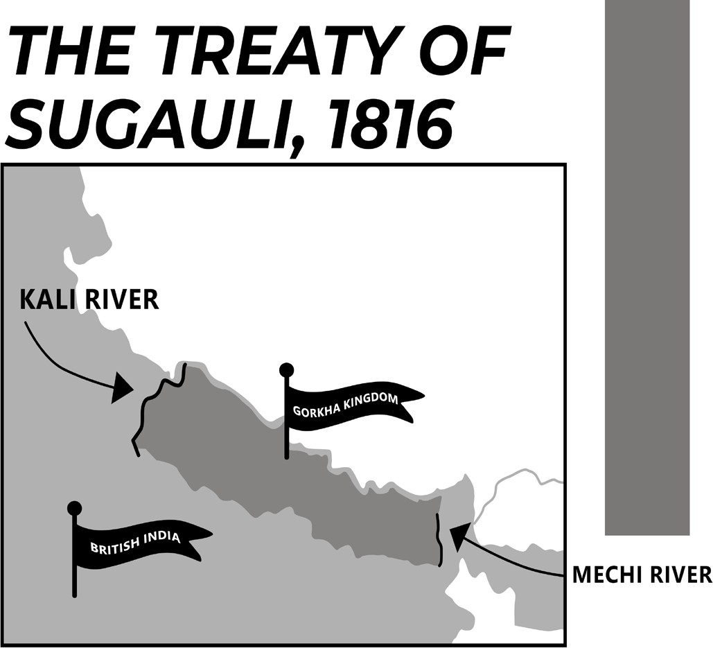
Figure: Treaty of Sugauli
Border Issues with Nepal
• Shifting Himalayan Rivers: Disputes frequently arise due to the ever-changing course of turbulent Himalayan rivers, particularly in areas like Kalapani and Susta.
• Encroachment Issues: The submergence, displacement, and destruction of border pillars, along with unauthorized occupation of no-man’s land by individuals from both sides, contribute to tensions.
• Reports of coercion and forced land acquisition along contested border regions emerge periodically.
• Unregulated Migration: Over time, continuous migration has led to the formation of territorial pockets dominated by populations originating from the neighboring country.
• Terrorist Infiltration: The open border facilitates easy movement for terrorists and insurgents.
• During the late 1980s, Sikh and Kashmiri extremists entered India through Nepal.
• Groups like ULFA, NDBF, and KLO have previously exploited the open border.
• In the past, Maoists reportedly sought refuge in India when pursued by Nepalese security forces.
• Organizations such as ISI, LeT, and other extremist groups continue to use Nepal as a transit route and operational base.
The Kalapani Issue
• Trijunction between India, Nepal, and China and the three areas of interest in this trijunction are Limpiyadhura pass, Lipulekh, and Kalapani.
• For India, this trijunction is strategically important in the defence against China.
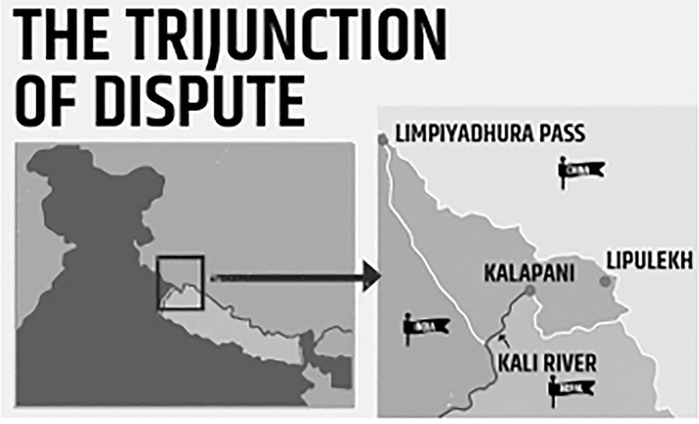
Figure: India-Nepal-China Trijunction issue
• For more than a hundred years there was no dispute between India and Nepal over this trijunction.
• In fact, during the 1962 war with China, India had deployed troops at the trijunction to check Chinese aggression. Even now, Indian troop deployment continues in many parts there.
• But the situation changed in the 1990s when Nepal shifted from a monarchy to a democratic government.
• In 2015, India and China agreed to use Lipulekh to further trade between the two countries. The then Nepalese prime minister Sushil Koirala raised strong objections to the deal.
• In 2022, Nepal released a new political map that claims Kalapani, Limpiyadhura and Lipulekh of Uttarakhand as part of Nepal’s territory.
The Susta Region
• Susta is located on the bank of the Gandak river.
• The change of course by the Gandak river is the main reason for disputes in the Susta area.

Figure: Susta Region
• The Latest Standoff
• Nepal deployed armed police along its border, one Indian citizen was killed in a firing incident.
• Moreover, the new Nepalese map shows Indian territory within Nepal's borders.
• At the same time, for the Nepalese government, facing criticism over the mismanagement of the COVID-19
situation in the country, winning this ‘nationalistic battle’ is crucial for its political stability.
EFFORTS TO RESOLVE ISSUES-
• The Nepal-India Joint Border Inspection Mechanism of 1981 and the Nepal-India Joint Border Management Committee, formed in 1997, are both noteworthy in the discussion about efforts that have been made by both countries in the past.
• Additionally, in order to make agreements and bilateral talks on border clearer, the Nepal-India Joint Technical Level Boundary Committee (JTBC) was constituted in 1981 (dissolved in 2008).
• These organisations mainly worked to bring about a comprehensive border management system along with the re-establishment of the boundary pillars from the British era and the periodic inspection of keeping the boundary intact.
• Boundary base maps and strip maps of 1:15000 scale covering 50 meters from either side were also created with the construction of boundary pillars—which are basically subsidiary or additional pillars in the specific riverine segments.
CONCLUSION
• Both India and Nepal must invest in negotiating new border management agreements to take into consideration recent events.
• India should also move beyond its insecurities related to China.
• After all, the demands of the times have changed since the time the Kalapani border dispute first emerged. In the process, the people of both countries should be prioritised.
Indo-Myanmar Border
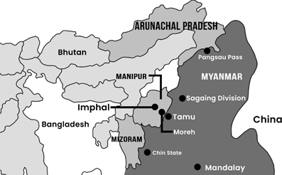
Figure: India-Myanmar Border
• India shares a 1,643 km long land border as well as a maritime boundary in the Bay of Bengal with Myanmar. The land border passes through the States of-
• Arunachal Pradesh (520 km),
• Nagaland (215 km),
• Manipur (398 km) and
• Mizoram (510 km).
• It runs from the tripoint with China in the north (de facto tripoint is located just north of the Diphu Pass) to the tripoint with Bangladesh in the south. The land boundary was demarcated in 1967 under an agreement signed by both countries. Out of 1,643 km, demarcation of 1,472 km has been completed.
• Unfenced border and unregulated migration from Myanmar have been attributed as some of the factors responsible for the ethnic violence in Manipur.
• The Indian Army’s Assam Rifles is the border guarding force deployed along the Myanmar border.
• There is a Free Movement Regime (FMR) implemented since 2018 along India-Myanmar border under Act East Policy. It is a mutually agreed arrangement between the two countries that allows tribes living along the border on either side to travel up to 16 km inside the other country without a visa.
Challenges
• Terrain & Location: The location of the Indo-Myanmar border throws up many challenges for its effective management. The rugged terrain makes movement and overall development of the area difficult
Unrestricted Borders: Although the boundary is well- defined, certain areas remain disputed. There are no significant physical barriers like fences, border outposts, or roads to facilitate stringent monitoring.
Historical Conflicts: The security of border regions is impacted by internal regional dynamics, including tribal loyalties, inter-tribal conflicts, insurgency, and cross- border ethnic connections. For instance, the movement of Rohingya refugees has added to the challenges.
• Insurgent Activities: Strong ethnic ties among tribes such as the Nagas, Kukis, and Chin, who reside on both sides of the border, provide insurgents with safe havens in Myanmar.
Misuse of Free Movement Regime (FMR): This provision has also contributed to increased smuggling in the region.
• Drug Smuggling: The border's proximity to the "Golden Triangle" enables the unchecked influx of illegal drugs into India.
• Illicit Trade of Arms and Goods:
Weapons, ammunition, precious stones, and Chinese-manufactured consumer products are illegally brought into India.
Items such as "Red Sanders, amphetamine-type stimulants (ATS), groceries, and bicycle parts" are smuggled out of India.
Human Trafficking: Thebo rder regionalso experiences a high incidence of human trafficking.
Steps Taken
• Bilateral Cooperation: Memorandum of Understanding (MoU) was signed between India and Myanmar in 2019 for enhancing bilateral cooperation on the prevention, rescue, recovery, and repatriation of persons who have been trafficked.
• Border Demarcation: Out of the total 1,643 km Indo- Myanmar border, 1,472 km has been successfully demarcated. However, two sections remain unresolved:
• Lohit sub-sector in Arunachal Pradesh – 136 km
• Kabaw Valley in Manipur – 35 km
• To check fake Indian currency and animal trafficking, the Government has adopted a multi-pronged approach which inter-alia includes round-the-clock surveillance and patrolling on the borders and establishment of observation post;
• Higher Deployment and Out Posts: Increase in number of BSF personnel and use of water crafts/boats and floating Border Out Posts (BOP) for domination of riverine area;
• Use of Technology: Hand Held Thermal Imager (HHTI), Night Vision Device (NVD), Twin Telescope, Unmanned Aerial Vehicles (UAV) etc.
• The Manipur government has suspended the Free Movement Regime (FMR) since 2020, post COVID-19 pandemic.
• Barbed wire fencing and floodlighting are being erected along around 400 km India-Myanmar border with Manipur.
• Connectivity:
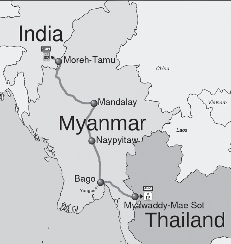
Figure: Connectivity between India and Myanmar
• India-Myanmar-Thailand Trilateral Highway is a 1,360-km long trans-nation highway to boost trade
and tourism, under India's Act East policy that will connect Moreh, India with Mae Sot, Thailand via Myanmar.
• The 160 km (99 mi) long India–Myanmar Friendship Road, linking Moreh-Tamu-Kalemyo-Kalewa, was officially inaugurated on 13 February 2001, and it now forms a part of the trilateral highway.
• The Kaladan Multimodal Transit Transport Project is connecting Kolkata with Sittwe seaport in Rakhine State, Myanmar by sea.
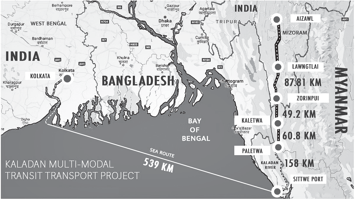
Figure: Kaladan Multimodal Transit Transport Project
• Cross Border Trade:
• Trade Development of Integrated Check Post at Moreh (Manipur) by Department of Border Management to facilitate cross-border trade and movement of passengers.
• Border Haat at Pangsau Pass, Arunachal Pradesh: This location has been mutually agreed upon between India and Myanmar to open the first Border Haat or Trading Post on the Indo-Myanmar border as per the Joint Statement in May, 2004.
Way Forward
• Bilateral Cooperation: Being the only country that intersects India's “Act East Policy” and “Neighbourhood First Policy”, strengthening diplomatic and security ties with Myanmar is necessary. Regular dialogues and joint operations can help address common security challenges.
• Strengthen Intelligence Sharing: Both India and Myanmar should enhance intelligence sharing on insurgent groups, drug traffickers, and other criminal elements. Joint intelligence operations can help track and neutralize threats.
• Legal Framework: Extradition Agreements and legal mechanisms to facilitate the handover of criminals and insurgents operating across the border.
• Enhanced Border Surveillance: Improve border infrastructure, deploy modern technology such as surveillance cameras, drones, and sensor systems, and increase the training of security forces to monitor and control border activities effectively.
•
Troop Deployment: India hopes to curtail cross- border crime, including goods, arms and counterfeit Indian currency smuggling, drug trafficking, and insurgency.
• Indo-Myanmar Border Force (IMBF) is a new proposed force under ITBP, composed of 29 battalions
- 25 battalions from Assam Rifles and 4 battalions from Indo-Tibetan Border Police - to guard and patrol the border to the zero line.
• Customs and Border Control: Strengthen customs enforcement to curb illegal trade, arms smuggling, and drug trafficking. Encourage legal trade and commerce to boost the local economy.
• Development Initiatives:
Invest in the socio-economic development of the border regions to address the root causes of insurgency and to provide livelihood alternatives to the local population such as Border Area Development Programme (BADP).
• Community Engagement:
• Engage with local communities to gather intelligence, build trust, and encourage them to resist the influence of insurgent groups. Community policing initiatives can be beneficial.
• Peace Initiatives: Encourage dialogue and negotiations with insurgent groups to resolve conflicts peacefully. Myanmar's cooperation is crucial in this regard.
• International Cooperation: Seek the cooperation of regional and international partners in countering transnational crimes, including drug trafficking and arms smuggling.
Indo-Bhutan Border
• The Bhutan-India Border is the international boundary between the Kingdom of Bhutan and the Republic of India. India and Bhutan share open borders. Nationals from both countries can cross freely without visa requirements.
• The border is 699 km long, and adjoins the Indian states of Assam (267 km), Arunachal Pradesh (217 km), West Bengal (183 km), and Sikkim (32 km).
• Single Entry Point: The "India-Bhutan border" serves as the only land route for entering Bhutan, as its border with China remains completely sealed.
Foreign nationals can enter Bhutan through a single official checkpoint, located between Jaigaon in West Bengal and Phuntsholing in southwestern Bhutan.
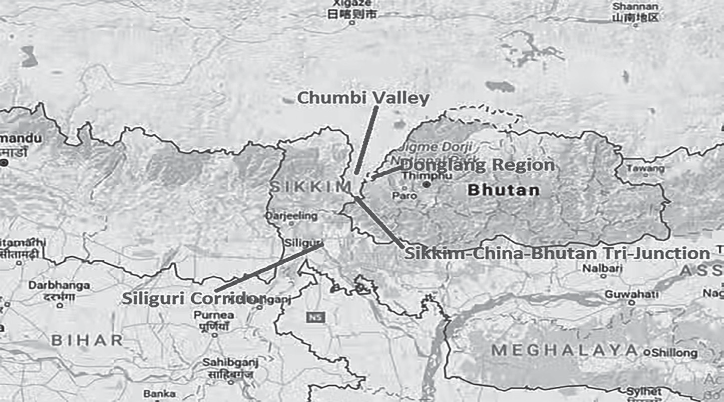
Figure: India-Bhutan Border
• To secure the border, the Indian government has stationed 12 battalions of the Sashastra Seema Bal (SSB) and established 132 border posts.
• The "India-Bhutan Group for Border Management and Security" has been formed to jointly evaluate and enhance border security between both nations.
• The boundary is demarcated except along the tri- junction with China, where the boundary is open.
• Recently India helped in maintaining the territorial integrity of Bhutan from advancing Chinese troops during the Doklam or Donglang standoff 2017.
Challenges in managing Indo-Bhutan border
•
Insurgent Movement: The border remained peaceful until Indian insurgent groups like KLO, ULFA, and NDBF set up camps in Bhutan’s southern districts. Although these camps were later dismantled, insurgents exploited the open border to retreat into Bhutan after committing extortion, killings, and bomb attacks.
• Smuggling and trafficking are also rampant along the border.
• India sees significant smuggling of items such as Chinese-manufactured goods, Bhutanese cannabis, liquor, and forest resources.
• On the other hand, livestock, groceries, and fruits are illegally transported into Bhutan.
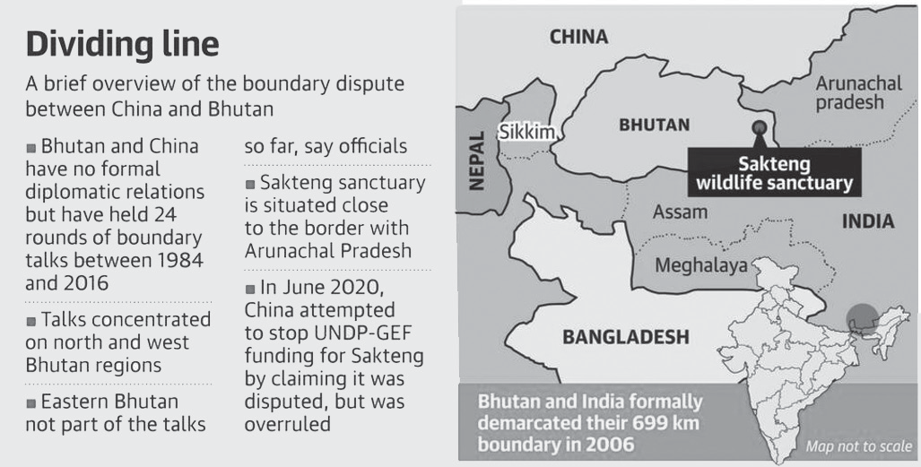
Figure: Boundary dispute between China and Bhutan
Steps Taken
• Border Demarcation: In 2006, a final Border Demarcation Treaty was signed.
• Border Management:
• The India-Bhutan Group for Border Management and Security has been formed to jointly evaluate and strengthen border security between the two nations.
• Additionally, a Border District Coordination Meeting Mechanism exists between the bordering Indian states and the Royal Government of Bhutan to enhance cooperation on border management and related issues.
• Connectivity:
• Proposed India-Bhutan Railway Link Project 2023 involves a 57.5-km railway line that will seamlessly connect Kokrajhar in Assam, India, to Gelephu in Sarpang, Bhutan. By being a part of this railway network, doors will be open to the transnational movement of goods, people, and ideas apart from strengthening regional connectivity.
• In 2020, a new trade route between Jaigaon in Bengal to Pasakha in Bhutan, which will further the camaraderie.
• Project Dantak has completed approximately 1600 km of blacktopped roads and 120 km of tracks in Bhutan with 5000 meters of bridges over them.
Include the construction of Paro Airport, Yonphula Airfield, Thimphu – Trashigang Highway, Telecommunication & Hydro Power Infrastructure, Sherubtse College, Kanglung and India House Estate.
• Bangladesh-Bhutan-India-Nepal (BBIN) Corridor has been on progress to enhance trade and connectivity between the two countries. The Motor Vehicle Agreement (MVA) was signed by the BBIN countries in 2015 with the object of facilitating the unrestricted movement of cargo, persons, and personal vehicles between the four South Asian countries.
The BBIN project suffered a setback in 2017 when Bhutan temporarily opted out of it after being unable to get parliamentary approval for the MVA.
Way Forward:
• Bhutan’s concerns may ease if inclusion of waterways and riverine channels is considered as a less environmentally damaging substitute.
Border Management Challenges
BORDER MANAGEMENT CHALLENGES
• Boundary Issues
• Lack of proper demarcation of maritime and land borders at many places in case of Bangladesh and Myanmar.
• Artificial boundaries: Extremely porous and easy to infiltrate.
• Disputes with neighbours- Sporadic aggression on China border, Indo-Pak Border dispute at Sir Creek and Kashmir.
International Disputes
Water-sharing issues such as River water sharing issue on the Indus River with Pakistan and Teesta River Dispute with Bangladesh.
Illegal Migration in eastern region causing socio- economic stress as well as demographic changes like Bangladeshi and Rohingya refugees.
Terrorism & Smuggling
Hostile elements have access to latest technology, money power, organisational strength, maneuverability etc.
Cross-border terrorism targeted to destabilise India.
Cross border safe houses for insurgent in north eastern neighbours.
Smuggling of arms and explosives, narcotics and counterfeit currency.
Enhanced instances of smuggling, piracy, breach of coastal security.
Resource Deficient -
Coordination Issues: The presence of multiple security agencies along the same borders creates challenges in coordination, command, and control.
Insufficient Infrastructure: Border security forces, such as the BSF, face infrastructure deficiencies and require enhancements in both manpower and equipment.
Discontent among local people:
Problems faced by local people due to tough measures taken during anti-terrorism and anti-insurgency operations generate discontent.
Technological Challenges
Many of the high-tech surveillance devices deployed by the BSF are not optimally utilized.
The exorbitant cost of the electronic devices acts as a deterrent against their use.
Erratic power supply and adverse climatic and terrain conditions in border areas.
Steps Taken
Department of Border Management was created in the Ministry of Home Affairs in January, 2004 to devote focused attention to the issues relating to-
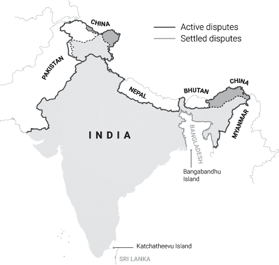
Figure: Disputed Borders of India
The management of the international land and coastal borders,
Strengthening of border policing and guarding,
Creation of infrastructure such as roads, fencing, flood lighting and Border Out Posts (BOPs)/Company Operating Bases (COBs) at the borders and
Implementation of the Border Area Development Programme (BADP).
'One Border, One Border Guarding Force (OGOBGF)
• The approach to border management differs for each border, depending on security concerns and the nature of relations with the neighboring country. Specific border areas are assigned to different security forces:
• The Border Security Force (BSF) is responsible for guarding the Bangladesh and Pakistan borders.
• The Indo-Tibetan Border Police (ITBP) manages security along the China border.
The Sashastra Seema Bal (SSB)oversees the Nepal and Bhutan borders.
The Assam Rifles is in charge of securing the Myanmar border.
Additionally, the Indian Army, alongside the BSF, protects land borders along the Line of Control (LoC) with Pakistan, while it works with the ITBP along the Line of Actual Control (LAC) with China.
For maritime security, the Indian Navy has overall responsibility, covering both coastal and offshore areas. The Indian Coast Guard has been assigned authority over coastal security within India's territorial waters, including regions monitored by the Coastal Police.
Strengthen Border Security Arrangements
Implementation of Comprehensive Integrated Border Management System (CIBMS)
To establish an integrated security system at borders
providing all-round security even in adverse climatic conditions.
• To improve situational awareness at different levels of hierarchy to facilitate prompt and quick response to emerging situations along the India-Pakistan Border (IPB) and India-Bangladesh Border (IBB
• It integrates manpower, sensors, networks, intelligence and command control solutions. It has three main components:
New high-tech surveillance devices
An efficient and dedicated communication network
A command-and-control center to which data will be transmitted
• A unit of Indian Special Forces has been deployed to strengthen counter-terror operations by training J&K police and other paramilitary forces in room intervention tactics, anti-terror strategies, and overseeing anti- hijacking operations.
• A new intelligence wing has been set up within the SSB along the Indo-Nepal and Indo-Bhutan borders to enhance operational effectiveness.
Border Infrastructure and Management (BIM) Scheme:
• It is a Central Sector Scheme. The scheme aims to enhance the security along the borders of the country and involve implementing a number of projects for the development of border infrastructure such as
• Border Fence,
• Border Roads,
• Border Floodlights,
• Border Out Posts (BOPs),
• Helipads and
• Foot Tracks along the international borders of the country.
• It also involves deployment of technological solutions in such patches of the borders, which are not feasible for physical fence.
• Technology can be integrated with the existing systems to facilitate better decision and interception.
• Specialized Communication satellites are deployed by India like RISAT and Cartosat to capture high resolution images and video footage of disputed border areas furthering enhanced intelligence gathering and border surveillance
• Navigation Support: The Indian Regional Navigation Satellite System (IRNSS)-based GPS aids operational teams by providing navigation assistance in remote, high-altitude border regions and areas affected by Maoist insurgency.
Strengthening Border Connectivity
Government of India has approved construction of 1377 km of roads along Nepal border.
Establishing new border posts in Sikkim along the Bhutan frontier near Doklam.
Government has given a general approval for the diversion of forest land for major border infrastructure projects along the eastern border with Bhutan, Myanmar, and Nepal.
Developing Border Areas
Border Area Development Programme (BADP) introduced in the year 1993-94 as a Centrally Sponsored Scheme.
The ambit of the programme includes socio-economic aspects such as education, health, agriculture and other allied sectors for the remote villages existing near border areas.
Being implemented in 16 State and 2 Union Territories located along the international border.
Vibrant Villages Programme introduced in 2023, provides for infrastructural development of remote and less populated villages existing specifically across Indo-China border.
Cultivating Favourable Perception Amongst Locals
Ensure that the security forces respect the rights and dignity of the local population and do not engage in abusive or discriminatory practices.
It is also important to communicate openly and transparently with the local community about the reasons for security measures and efforts to address their problems.
International Efforts
Security cooperation with friendly countries’ army to prevent sanctuary to insurgents on their soil.
Development aid to Nepal to prevent human trafficking owing to lack of employment opportunities there.
Secretary-level Mechanism for India-Bhutan border management and security.
Establishment of Border District Coordination Committee at the level of district officials of the two countries to discuss issues of mutual concern.
Neighbourhood Projects have been initiated such as:
CrossBo rder petroleumpipeline Motihari– Amlekhgunj with Nepal
Mahakali Motorable Bridge connecting Dharchula (in India and Nepal)
High speed Diesel Maitri Setu pipeline with Bangladesh
Sittwe port and Kaladan Multi modal Transit Transport Project with Myanmar