Whatsapp 88106-52225 For Details
Get Free IAS Booklet
Get Free IAS Booklet
INTRODUCTION
Air mass
An air mass is a large body of air with uniform temperature and humidity characteristics throughout. These characteristics are acquired when the air mass remains stationary over a particular region, known as its source region, for an extended period.
Air masses are typically associated with high-pressure systems because they bring stable weather conditions due to their uniform characteristics.
Classification Based on Moisture Content
• Continental Air Masses (c): These air masses originate over continents and are therefore dry.
• Maritime Air Masses (m): Originating over oceans, maritime air masses are moist.
Further Classification Based on Temperature
• Arctic Air Masses (A): Extremely cold air masses originating from the Arctic or Antarctic regions.
• Polar Air Masses (P): Cold air masses originating from higher latitudes, both over land and sea.
• Tropical Air Masses (T): Warm to hot air masses originating from lower latitudes, both over land and sea.
• By combining moisture content (continental or maritime) with temperature (Arctic, polar, or tropical), meteorologists
can classify air masses into distinct categories, allowing for a more precise understanding of their characteristics and behavior in weather systems.
ORIGIN OF AIR MASS
A source region is the area where an air mass begins its development. During this process, the air mass acquires the temperature, pressure and moisture characteristics of the source region.
Characteristics of a Good Source Region
• Fairly Uniform Extensive Area: A good source region is characterized by a large, uniform area where air can develop consistently.
• Relatively Flat and Homogeneous: The source region should be relatively flat and homogenous, with similar physical conditions throughout. This ensures that the air mass acquires consistent properties as it develops.
• Prevailing Calm Conditions: Calm conditions are preferable in the source region, as turbulent weather can disrupt the development of the air mass.
• Preferably High-Pressure Conditions: High-pressure conditions are ideal for air mass development, as they promote stability and allow for gradual acquisition of properties from the source region.
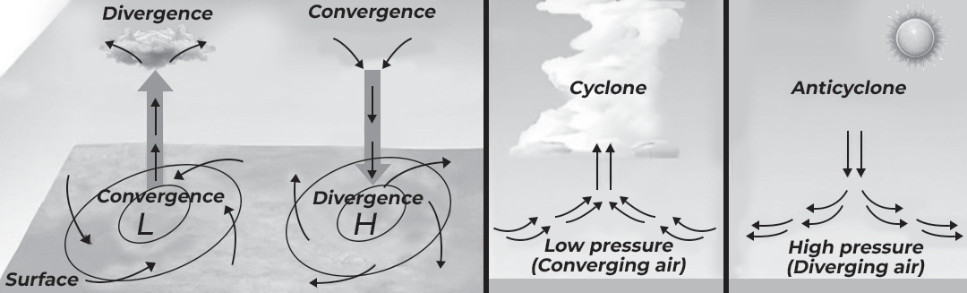
(Fig- Formation of Air Mass)
• High-pressure zones in the Earth’s atmospheric circulation, such as the subtropical subsiding zone and thermally induced polar zones, serve as source regions for air mass development. These areas feature vertically subsiding air and relatively stable, high-pressure conditions with low horizontal pressure gradients.
• The divergent air circulation in these high-pressure zones creates stable volumes of air, making them ideal for the development of air masses. Unlike the mid-latitude regions, which are dominated by cyclonic disturbances and local weather phenomena, these source regions are relatively devoid of such activities.
• The characteristics of the source region determine the properties of the air mass that develops there. These properties include temperature and humidity, which play a crucial role in maintaining equilibrium within the air mass. As air masses move away from their source regions, their characteristics may change gradually, influenced by the surrounding environment.
• Source regions are characterized by stationary or slow-moving anticyclones with calm or light winds. These conditions allow for the gradual acquisition of temperature and moisture characteristics by the air mass, resulting in relatively uniform and stable properties.
Determining factors of Air Mass
The nature of air masses is primarily determined by three factors. They are:
Source region,
Duration of air mass stability
Natural changes or modification with time and space
Classification of Air Masses
The primary classification of air masses is based on the characteristics of the source region.
They could be
• Arctic (A)
• Polar (P)
• Tropical (T)
There are five major source regions of air masses
• Warm tropical and subtropical oceans;
• The subtropical hot deserts;
• The relatively cold high latitude oceans;
• The very cold snow-covered continents in high latitudes;
• Permanently ice-covered continents in the Arctic and Antarctica.
Tropical air masses are warm and polar air masses are cold. The heat transfer processes from the arriving air mass changes the characteristics of the reached areas. Warm air mass makes the area warmer than what it was before, whereas the cold air mass turns the area cooler than the original temperature conditions already prevailing.
On the basis of the characteristics of the surface, they are
• Continental (c) and
• Maritime (m)
Types of Air Masses on the basis of Source Region
Based on Temperature Conditions, air masses can be listed into two categories as follows:
• Polar (cold) and
• Tropical (warm)
Polar Air Mass (cold)
A polar air mass is defined as an air mass with temperatures lower than that of the underlying surface. These air masses are typically associated with instability and high atmospheric turbulence due to the sharp temperature contrast with the surface below.
Characteristics and Associations
• High Pressure Centers: Polar air masses are associated with high-pressure systems on surface weather maps. These centers of high pressure are indicative of the heavier and denser nature of the cold air, which displaces warmer air masses.
• Dynamic Interaction: When polar air masses encounter warmer air masses, they act as a wedge, forcing the warmer air rapidly upward at a sharp angle. This interaction results in a steeper wedge compared to warm fronts and contributes to the development of weather phenomena such as storms and frontal systems.
• Origination Regions: Polar air masses generally originate in specific regions known for their cold and dry or cold and moist conditions. These regions include:
Arctic Ocean: Characterized by cold and moist air.
Siberia: Known for cold and dry air.
Northern Canada: Also characterized by cold and dry air.
Southern Ocean: Known for cold and moist air.
Tropical Air Mass (warm)
• A warm air mass is characterized by being warmer than the underlying surface and is a warm and moist air mass is more prone to instability. The centers of very warm air masses often appear as semi-permanent regions of low pressure on surface weather maps.
• Warm air masses create wide bands of weather due to the eastward movement of light warm air. Due to their instability and high temperature, these air masses have high humidity, resulting in cloud cover and precipitation.
• The classification of an air mass as cold or hot depends on the temperature of the surface area over which it moves.
Classification Based on Source of Origin
• Tropical Deserts: These air masses originate from tropical deserts and are warm and dry in nature.
• Tropical Oceans: Originating from tropical oceans, these air masses are warm and moist.
Factors Influencing Aridity
• Offshore Trade Winds and Rain Shadows: Moist trade winds blow from east to west, releasing moisture on the eastern sides of continents. By the time they reach the western sides, they are dry, contributing to arid conditions.
• Anticyclonic Conditions: Between 20 and 30 latitude on the western sides of continents, descending air masses lead to compression and warming, decreasing humidity and contributing to desert formation.
• Rain Shadow Zones: Mountains block moisture-laden clouds, creating drier rain shadow zones on the leeward side.
• Cold Ocean Currents: Cold ocean currents along western coasts stabilize the air, preventing cloud formation and rainfall, thus contributing to arid conditions and the formation of coastal deserts.
Air Masses Based on Latitudinal Extension
• Air masses in tropical regions are warm, while those in polar regions are cold. This temperature difference is a result of the varying latitudinal positions and climatic conditions of these regions.
• The alteration of air mass characteristics occurs through the processes of conduction or convection, which facilitate the transfer of heat within the atmosphere. Conduction involves the transfer of heat through direct contact between air molecules or between the air and the Earth’s surface. Convection, on the other hand, involves the movement of air masses, which results in the transfer of heat from one location to another.
• Whether through migration or movement of air masses, or through gradual changes occurring at the same location, the alteration of air mass characteristics is a slow process. This gradual change allows for the adjustment of temperature, humidity, and other properties of the air mass to align with the conditions of the surrounding environment.
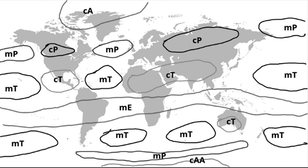
(Fig-Air Masses o f the world)
Maritime Tropical
• Maritime Tropical air masses originate from sub-tropical anticyclones (high-pressure cells) that persist over the oceans around latitude 30 N and 30 S throughout the year.
• These air masses originate from tropical and subtropical oceans such as the Atlantic and Pacific, extending to the Gulf of Mexico. They exhibit distinct characteristics during both summer and winter, influencing local climates.
• Maritime Tropical air masses are warm, unstable, and humid due to the warm waters beneath them. During summer, they absorb moisture from the lower layers, facilitated by the higher temperatures. As the air rises from subtropical to higher latitudes, it gradually cools down due to contact with colder sea and land surfaces, reducing the normal lapse rate and increasing stability.
• The cooling process increases relative humidity, leading to the formation of fog and light drizzle to steady rain, often accompanied by stratus clouds. Winters under Maritime Tropical influence are typically mild with overcast conditions and fog.
• In summer, Maritime Tropical air masses bring heavy rain to hot continental regions as they move over warmer seas, exhibiting unstable characteristics. Eastern coastal regions of mid-latitudes receive significant rainfall from these air masses. Summers are characterized by high temperatures, humidity, cumulus clouds, and convectional rain.
Continental Tropical
• Continental Tropical air masses are hot, stable, and dry winds originating from tropical and subtropical desert areas such as the Sahara in North Africa, Asia, and Australia. These winds, known locally as the Harmattan in North Africa, are prevalent in the western drier margins of North America (USA) during summers. They also originate from the arid regions of Australia.
• Continental Tropical air masses generally do not extend beyond their source regions. They remain hot and unstable during summers and dry throughout the year, with minimal humidity. Despite being in unstable zones, the combination of high temperature and low humidity results in a high condensation level but no rainfall occurs.
• In winter, the air remains warm and dry but becomes stably stratified as it is found in anticyclonic zones with descending air. These stable winds tend to be localized and do not move much. However, when they encounter cooler surfaces, their stability increases, particularly where they meet cold air masses. Fronts may occur in regions like the Mediterranean.
• Continental Tropical air masses are dry throughout the year with minimal rainfall compared to tropical maritime air masses.
Continental Polar
• Continental Polar air masses originate from polar regions such as Antarctica, the Arctic basin, Eurasia and northern North America. These air masses are characterized by being dry, stable and very cold.
• The wind circulation within Continental Polar air masses is gentle and divergent. This circulation pattern contributes to their stable and dry nature.
• The winds associated with Continental Polar air masses are very dense and cold. This coldness is primarily due to the distance from warmer water bodies (oceans) and the continuous terrestrial radiation experienced in polar regions.
• In summers, Continental Polar air masses may become warmer and less stable, with a decrease or absence of prevailing anticyclonic winds. However, winters are characterized by frigid temperatures, clear skies and stability, with minimal cloudiness. Precipitation in the form of snow or ice is common during winter months.
Maritime Polar
• Maritime Polar air masses originate from the oceans located between latitudes 40 and 60 . When these air masses move over warmer water bodies like oceans, they become heated up and absorb moisture, resulting in increased humidity. This warmed and moistened air mass is referred to as Maritime Polar air mass.
• Regions influenced by Maritime Polar air masses are characterized by cool, moist and unstable air.
• These regions experience dynamic weather conditions that cannot remain stagnant for long periods. Summers are stable, clear and fair in this zone due to the influence of Maritime Polar air masses. However, winters are characterized by high humidity, mild temperatures, overcast skies and occasional fog and precipitation.
Continental Arctic
• Continental Arctic air masses form over large areas of snow and ice near the poles in both the Northern and Southern Hemispheres.
• These air masses tend to form during the winter months, from December to March in the Northern Hemisphere, and from June to September in the Southern Hemisphere. During these times, the polar regions experience extreme cold temperatures and minimal insolation (solar radiation).
Influence of air masses on the world climate
Transport of Moisture: Air masses carry atmospheric moisture from oceans to continents, resulting in precipitation over landmasses. This movement of moisture contributes to the distribution of rainfall across different regions.
Temperature Regulation: Maritime polar air masses play a role in influencing coastal temperatures in subtropical and arctic regions. The presence of these air masses can moderate temperatures, affecting local climate conditions.
Contribution to Cyclone Formation: When different air masses mix, it can lead to the rising of air, which fuels the formation of cyclones, particularly subtropical cyclones. For example, the interaction between warm maritime tropical air masses and other air masses provides the energy necessary for the development of tropical cyclones.
Arid Conditions and Desertification: The presence of dry air masses in certain regions can lead to arid conditions and desertification. This process can result in the destruction of natural vegetation and increase the risk of devastating wildfires. Example: Occurrence of wildfires in California
FRONT
Fronts are boundaries between air masses of different temperatures. It is actually zones of transition, but sometimes the transition zone, called a frontal zone, can be quite sharp. The type of front depends on both the direction in which the air mass is moving and the characteristics of the air mass.
• There are four types of fronts that will be described below: cold front, warm front, stationary front, and occluded front.
Cold Front
A cold-front forms when a cold air mass advances into a region occupied by warmer air. Cold fronts typically move quickly, often twice as fast as warm fronts. As the cold air mass displaces the warmer air, it forces the warmer air to rise into the troposphere.
The rising warm air ahead of the cold front leads to the formation of cumulus or cumulonimbus clouds, which can result in thunderstorms.
As the cold front passes through an area, there are noticeable changes in weather conditions. Winds become gusty, temperatures drop suddenly, and heavy rain, hail, thunder, and lightning may occur.
Atmospheric pressure changes from falling to rising as the cold front passes through. Following the passage of a cold front, the weather may clear up, and cumulus clouds are replaced by stratus and stratocumulus clouds, or clear skies may prevail.
On weather maps, a cold front is represented by a solid blue line with filled-in triangles indicating the direction of movement. Temperature changes from warm to cold as one crosses the front line.
Significant shifts in wind direction occur with the passage of a cold front. Winds ahead of the front are southerly, turning westward as the front approaches. After the front passes, winds become northerly.
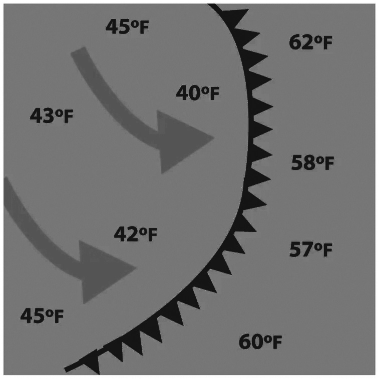
(Fig- Cold Front)
(Fig- Warm front)
Warm Front
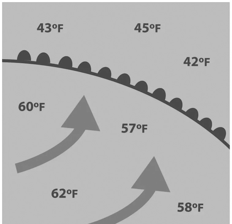
A warm-front forms when a warm air mass advances into an area occupied by cooler air.
Warm fronts often bring stormy weather because the warm air mass rises over the cooler air mass, leading to cloud formation and storms.
Warm fronts move more slowly than cold fronts due to the difficulty of pushing the denser, cooler air across the Earth’s surface.
Warm fronts typically form on the east side of low- pressure systems, where warmer air from the south is forced northward.
Clouds such as cirrus, cirrostratus, and middle clouds like altostratus appear ahead of a warm front. These clouds form in the warm air above the cooler air. As the warm front passes over an area, the clouds lower, and rain is likely. Thunderstorms may occur if the air is unstable.
On weather maps, warm fronts are represented by a solid red line with red, filled-in semicircles along it. The direction of movement is indicated by the orientation of
the semicircles, which are on the side of the line where the front is moving.
Stationary Front
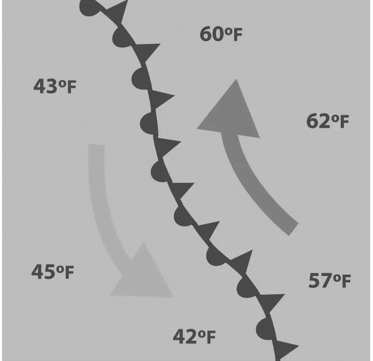
A stationary-front forms when a cold front or warm front stops moving due to equal opposing forces between two air masses. When winds blow parallel to the front instead of perpendicular, it helps the front stay stationary.
Stationary fronts may persist for days until wind direction changes, causing the front to resume movement as either a cold or warm front, or it may dissipate altogether.
Stationary fronts mark the boundary between two air masses, leading to differences in air temperature and wind on either side of the front.
Along a stationary front, weather conditions are often cloudy, and precipitation, such as rain or snow, is common, particularly if the front is located in an area of low atmospheric pressure.
On weather maps, a stationary front is represented by alternating red semicircles and blue triangles. The blue triangles and red semicircles point in opposite directions, indicating the direction of movement if the front were to resume motion.
(Fig- Stationary Front)
(Fig- Occluded Front)
Occluded Front
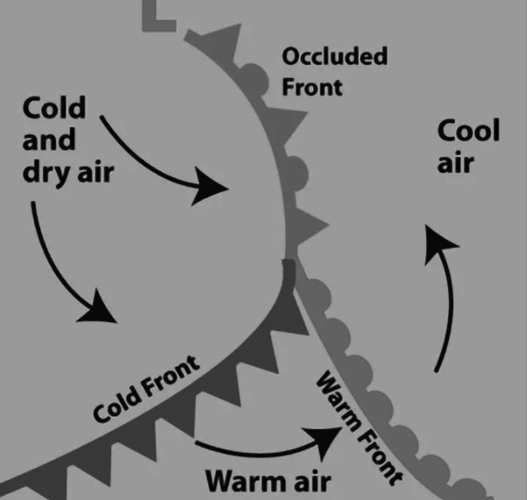
An occluded front occurs when a cold front catches up to and overtakes a warm front. This happens when a cold air mass from the cold front meets the cool air mass that was previously ahead of the warm front.
At an occluded front, the warm air is forced aloft by the approaching cold air masses. This lifting of warm air often leads to precipitation, typically from cumulonimbus or nimbostratus clouds. The direction of the wind changes as the front passes, and there may be a change in temperature as well. After the front passes, the sky tends to clear, and the air becomes drier.
Occluded fronts are associated with areas of low atmospheric pressure and are depicted on weather maps as purple lines with alternating triangles and semicircles pointing in the direction of movement. They typically terminate at a low- pressure system marked by a large ‘L’ on the map and begin where the cold and warm fronts connect.
Polar Front Theory
The theory posits that warm-humid air masses from the tropics meet dry-cold air masses from the poles, creating a polar front as a surface of discontinuity. These conditions typically occur over sub-tropical high-pressure belts, sub- polar low-pressure belts, and along the Tropopause.
When the cold air from the poles encounters the warm air from the tropics, it forces the warm air to rise upward. This displacement creates a void due to the reduction in pressure.
The surrounding air rushes in to occupy this void. Coupled with the Earth’s rotation, this movement of air leads to the formation of a cyclone. Cyclones are propelled forward by the westerlies, which are high-altitude wind currents known as Jet Streams.