Whatsapp 88106-52225 For Details
Get Free IAS Booklet
Get Free IAS Booklet
LANDFORMS DEVELOPMENT AND EVOLUTION
Landforms are the natural features found on Earth’s surface, including mountains, valleys, rivers and plains. These features are shaped by a combination of internal and external forces. • Internal forces, also called endogenous processes, originate from within the Earth. Plate tectonics is a significant internal force, causing the movement of Earth’s crustal plates and leading to the formation of mountains, volcanoes and rift valleys. Volcanism, another internal force, involves the eruption of magma onto the surface, creating new landforms. Uplift and subsidence, influenced by factors like plate movements and volcanic activity, lead to the rising or sinking of landmasses
External forces, known as exogenous processes, originate from external sources. Weathering is the breakdown of rocks and minerals through physical, chemical and biological processes. Erosion involves the removal and transport of weathered material by agents like water, wind, ice and gravity. Deposition occurs when eroded material settles in new locations.
These internal and external forces interact, with internal forces raising the land and external forces wearing it down. This continuous process of uplift and erosion shapes the Earth’s surface over time. Various geomorphic agents, such as water, glaciers, wind and waves play crucial roles in transporting and depositing eroded rock material from one place to another, further contributing to the formation and evolution of landforms. Overall, the combination of internal and external forces, along with geomorphic agents, results in the diverse and ever-changing landscapes found on Earth
ENDOGENIC FORCES
Endogenic forces refer to the geological processes that operate within the Earth’s crust and are responsible for shaping the land through activities such as upliftment and subsidence, folding, faulting, earthquakes, volcanic eruptions and other related phenomena. These forces originate from within the Earth and are primarily driven by factors like plate tectonics and internal heat processes.
On the other hand, exogenetic processes, also known as exogenic forces, originate from the Earth’s atmosphere and are actively engaged in the breakdown and alteration of major landforms created by endogenic forces. These processes occur on the Earth’s surface and are visible in various forms. They include weathering, erosion, transportation and deposition, which collectively work to reshape the Earth’s surface features over time. Diastrophic forces refer to significant movements occurring within the Earth’s crust, the rigid outer layer. This term encompasses all processes responsible for the deformation and movement of the Earth’s crust, which can occur gradually over time or suddenly with catastrophic effects. These processes include:
Mountain Building (Orogenic Processes)
It involves the uplift and folding of large segments of the Earth’s crust, typically associated with plate boundaries where tectonic plates collide, leading to the formation of mountain ranges.
Uplift or Warping of Large Parts (Epeirogenic Processes)
Vertical movements of the Earth’s crust that cause extensive areas of land to rise or sink. These movements are usually
slower than orogenic processes and are often linked to changes in the Earth’s mantle.
Earthquakes (Local Movements)
Sudden and violent movements of the Earth’s crust that result in ground shaking. Earthquakes occur due to the release of stored energy within rocks as they undergo stress and deformation. While earthquakes can happen anywhere on Earth’s surface, they are most common in regions where tectonic plates are actively moving.
Plate Tectonics (Horizontal Movements)
Refers to the lateral movement of the Earth’s tectonic plates, driven by convective currents in the Earth’s mantle. Plate movements lead to the formation of new continents, the opening and closing of oceans, and the creation of mountain systems.
Volcanism
The process through which molten rock (magma) erupts onto the Earth’s surface. Volcanic eruptions can be explosive or effusive and can produce various hazards such as lava flows, ash clouds and pyroclastic flows.
These diastrophic forces collectively shape the Earth’s surface and play a crucial role in the dynamic processes that drive geological evolution.
EXOGENIC PROCESSES
There are three fundamental types of exogenic processes that occur on the Earth’s surface: weathering, mass wasting and erosion.
Weathering
Weathering refers to the breakdown and decomposition of rocks in place due to weather phenomena such as temperature fluctuations, precipitation, freezing and thawing cycles, among others.
Mass wasting, also known as mass movement, is the process whereby weathered material moves downhill under the influence of gravity.
The theories of landform development were proposed by William Morris Davis, an American geographer and geomorphologist, and Walther Penck, a German geomorphologist. Erosion involves the movement of weathered material, primarily facilitated by various geomorphic agents such as rivers, glaciers, groundwater, ocean waves and wind, operating under different external processes.
Weathering is a static process, meaning it primarily involves the disintegration or decomposition of rock in place without the involvement of a transporting agency. The products of weathering, such as sand, clay, and rock fragments, accumulate on the spot to form a soft surface layer called regolith, which covers the bedrock. Scientifically, weathering is defined as the mechanical fracturing or chemical decomposition of rocks by natural agents at the Earth’s surface.
Weathering process is of mainly two types
• physical or mechanical weathering
• chemical weathering.
Physical or mechanical weathering is the process by which massive bedrock breaks down into smaller fragments, ranging in size from large blocks or boulders to fine sand and silt, through various physical stresses. This type of weathering involves the mechanical disintegration of rocks without any change in their chemical composition.
• It occurs through several mechanisms, including frost action, salt-crystal growth, thermal expansion and contraction and the mechanical action of plants and animals. In essence, physical weathering is a straightforward process involved in the gradual disintegration of rocks over time.
Chemical weathering refers to the breakdown of rocks through the alteration of their rock-forming minerals. This process involves various types of reactions between atmospheric and biotic agents. Certain minerals, such as olivine and augite found in basalt, are more prone to alteration compared to others like quartz, which is highly resistant to chemical change and only slightly soluble in water and even more so in saline water. Chemical weathering is most prominent in warm and humid climates where heat and moisture facilitate these reactions.
• Chemical weathering encompasses several processes, all of which are associated with moisture and contribute to the disintegration of minerals in rocks. The most significant processes of chemical weathering include carbonation, hydrolysis and oxidation. These processes play crucial roles in breaking down rock minerals over time, particularly in environments with ample heat and moisture.
Mass Wasting
Mass wasting, also known as mass movement, refers to the movement of weathered material down slopes under the influence of gravity, often aided by factors such as running water. This process occurs over relatively short distances and can be triggered by various factors, including geological structure (such as closely spaced joints or faults), rock composition and permeability, topography (such as steep slopes or cliffs), climatic factors (including temperature variations and heavy rainfall) and vegetation cover.
• The slope gradient plays a particularly significant role in mass wasting, as steeper slopes are more prone to movement. There are three main classes of mass movement: falls, slides, and flows, each characterized by distinct mechanisms of movement and types of material involved.
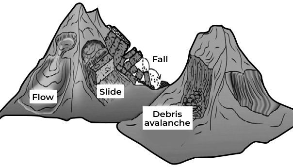
(Fig- Types of mass movement).
Some flows, such as earthflows and mudflows, are characterized by rapid movement and occur when soil becomes saturated with water. Earthflows typically occur on low-angle terraces or hillsides when water-saturated soil rapidly moves downslope. This can happen on any steep slope when underlying rocks become saturated during or after rainfall.
Mudflows, on the other hand, consist of a mass of saturated rock particles of various sizes, often triggered by sudden heavy rainfall or shallow groundwater. Runoff water carries soil and rock debris from a large slope area, transporting them to a valley or canyon. The water and debris then move down the canyon mouth and spread out onto the gentle slopes below. Mudflows are particularly common in arid and semi-arid regions.
Erosion
Erosion is a process by which various erosive agents acquire and remove rock debris from the Earth’s crust, transporting it over long distances. During erosion, if new relief features are formed, the process repeats until the features are leveled down to a featureless plain called a peneplain.
• This leveling of relief features to sea level through erosion is defined as the cycle of erosion.
• The concept of the cycle of erosion, also known as the geographic cycle of erosion, was initially proposed by William Morris Davis, an American geomorphologist and professor of physical geography at Harvard University, in 1899. This concept was a key idea in the history of geomorphology. Davis’s main concept was to organize landforms into a cycle of development.
Various action Agents of erosion: The principal agents of erosion, including running water, glaciers, groundwater, sea waves, and wind, play crucial roles in the erosion, transportation and deposition of materials on Earth’s surface.
• Among these agents, the work of rivers or running water stands out as one of the most significant exogenetic processes.
• Rivers effectively remove materials from land areas and transport them to the oceans.
River as an action agent
The work of rivers involves three closely interrelated activities: erosion, transportation, and deposition. Erosion by rivers is influenced by various processes such as hydraulic action, corrosion, abrasion and attrition.
Hydraulic action
Hydraulic action refers to the erosion process by which a river exerts mechanical force on the surrounding rocks and sediments due to the impact of its flowing water. This force can cause the breaking of rocks along the sides of the river valley and the erosion of loosely consolidated alluvial materials such as sand, silt, clay and gravel.
• Essentially, hydraulic action involves the loosening and removal of rock and sediment materials solely by the force of water.
Corrosion
Corrosion, in the context of river erosion, refers to the chemical process by which soluble materials in the stream channel are dissolved or undergo acid reactions, resulting in their removal. This process can lead to the dissolution of certain minerals or substances present in the rocks and sediments along the riverbed.
Abrasion
In addition to corrosion, another erosional process occurring in river channels is abrasion. This involves the mechanical wearing away of rocks and sediments due to the frictional force of the flowing water and the sediment load carried by the river. As the water and sediment move downstream, they can carve out cylindrical holes known as potholes, as well as create other features such as plunge pools, chutes, and troughs through the process of abrasion.
Attrition
Attrition refers to the process by which rock fragments, such as boulders and cobbles, collide with each other while being transported by the water. As these rock fragments collide and rub against one another, they undergo mechanical abrasion and are gradually broken down into smaller grains of sand and silt. This process of attrition contributes to the overall erosion and transportation of sediment by rivers, ultimately shaping the landscape over time.
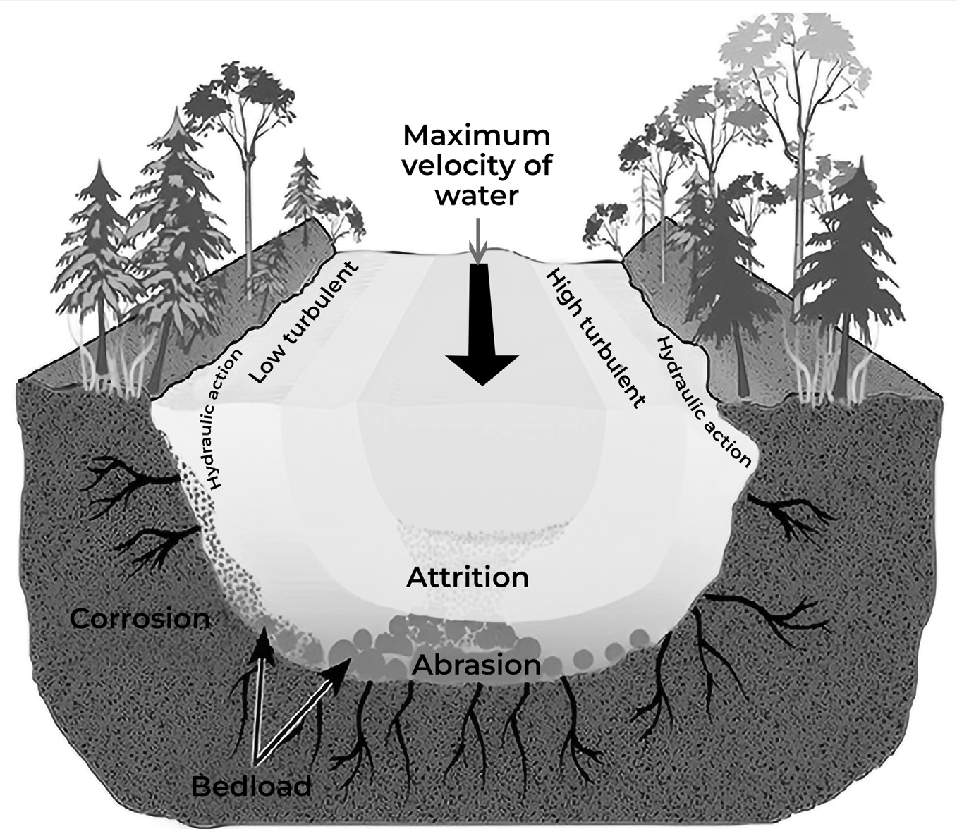
(Fig- Process involved in the river erosion)
FLUVIAL LANDFORMS
Fluvial landforms are those that result from the action of flowing water, predominantly from rivers and streams. These landforms are sculpted by various processes such as erosion, transportation, and deposition, which are driven by the flow of water and the characteristics of the surrounding landscape. Fluvial landforms can be broadly categorized into two types: erosional and depositional.
Erosional Fluvial Landforms: These landforms are created by the removal of material from the channel or banks of a river or stream. Examples of erosional fluvial landforms include: Waterfalls, Gorges and Meanders
Depositional Fluvial Landforms: These landforms are created by the accumulation of sediment within the channel or along the banks of a river or stream. Examples of depositional fluvial landforms include: Alluvial Fans, Deltas and Floodplains.
These fluvial landforms play a significant role in shaping the Earth’s surface and are important features of both natural landscapes and human environments
Geomorphic Agents
Geomorphological agents are natural forces that play a crucial role in shaping and modifying the Earth’s surface over extended periods. These agents interact with the Earth’s materials and processes to create various landforms and features.
Some of the key geomorphological agents include Water
Rivers: Rivers contribute significantly to landscape formation through erosion, transportation and deposition of sediment. They carve out valleys and canyons as they flow, shaping the surrounding terrain.
Ocean Waves: Waves along coastlines erode and shape coastal landforms through processes such as abrasion, hydraulic action and wave refraction. They can create features like sea cliffs, beaches and spits.
Groundwater: Groundwater plays a role in the formation of karst landscapes, characterized by features such as sinkholes, caves, and underground drainage systems.
Glaciers
Glaciers sculpt the landscape by eroding rocks and soil as they move downhill, forming U-shaped valleys and cirques. They also deposit sediment in the form of moraines drumlins, and eskers as they retreat.
Wind
Wind erosion occurs when fine particles like sand and silt are transported and deposited by wind. Wind can shape landscapes by forming sand dunes, deflation basins and ventifacts in arid and semi-arid regions.
Gravity
Gravity is a fundamental force that influences geomorphological processes such as mass movement
or mass wasting. Landslides, rockfalls, and debris flows are examples of mass movements caused by gravity.
Tectonic Activity
Tectonic activity, driven by internal heating of the Earth, results in processes such as earthquakes, mountain building and volcanic eruptions.
Courses of River
The course of a river can be divided into three main parts, each characterized by distinct features and processes:
• The upper or mountain course
• The middle or valley course
• The lower or plain course
Upper Course
The upper course of a river, originating from its source, is characterized by several distinctive features and processes:
Swift Flow and Vertical Corrasion
• The river flows swiftly as it descends steep slopes, leading to high flow rates.
• Vertical corrasion, or downward erosion, is predominant in this section due to the force of the flowing water.
• This results in the formation of deep, narrow, and V-shaped valleys, carved out by the river’s erosive action.
Down Cutting and Valley Formation
• The river channel erodes the landscape with great force, widening and deepening its valley through down-cutting.
• Lateral corrasion (sideways erosion) is outweighed by vertical corrasion due to the rapid down-cutting process.
• In regions where the rocks are highly resistant, narrow valleys with steep sides can form, creating gorges or canyons.
Landform Features
Landforms carved by the river in its upper course include V-shaped valleys, gorges, canyons, rapids, potholes, spurs and waterfalls.
• Rapids occur when water flows rapidly over a hard rock surface, causing turbulence and rough water.
• Waterfalls are formed when water plunges vertically downward, often over a sudden drop in elevation.
• Cataracts refer to falls of greater dimensions, similar to waterfalls but with larger dimensions.
• Plunge pools are large, deep holes formed at the base of waterfalls due to the erosive force of falling water.
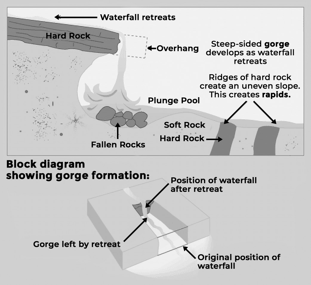
(Fig- Various landforms in upper course)
Middle Course
In the middle course of a river, as it flows through the plains, several notable changes occur:
Transition from Vertical to Lateral Corrasion
• In this section, lateral corrasion begins to replace vertical corrasion as the predominant erosional process.
• The river’s erosive action focuses more on the widening of valleys through the erosion of banks rather than deepening them.
Increase in River Load
• As the river gathers water from numerous tributaries, its volume and load increase significantly.
• The increased load includes sediment and other materials carried by the river, contributing to its erosive and depositional processes.
Transportation and Deposition
• Transportation becomes the primary function of the river in the middle course, accompanied by some deposition.
• Deposition occurs due to a sudden decrease in velocity as the river transitions from steep mountain slopes to gentler plains.
Formation of Landforms
• Landforms characteristic of the middle course include alluvial fans, floodplains, meanders, and ox- bow lakes.
• Alluvial fans form at the foot of mountains, where materials carried by the river from the upper course accumulate and spread-out fan- shaped.
• Bhabar plains are formed when multiple alluvial fans merge, creating a flat plain at the base of the mountains.
Lower Course
In the lower course of a river, the following characteristics and landforms are observed:
Reduced River Velocity
• As the river flows downstream into its lower course, its speed decreases significantly.
• The river traverses a wide, flat plain, laden with sediment and debris transported from the upper reaches.
Transition from Vertical to Lateral Erosion
• Vertical erosion diminishes substantially in the lower course, while lateral erosion continues to shape the riverbanks.
• Lateral erosion contributes to the ongoing erosion of
the riverbanks, albeit at a slower rate compared to the upper and middle courses.
Predominance of Deposition
• Deposition becomes the primary process in the lower course, with the river depositing sediment and building up its bed.
• This deposition leads to the formation of extensive floodplains along the river’s banks, characterized by fertile soil and periodic inundation during floods.
Formation of Landforms
• The lower course of a river is associated with the creation of specific landforms, notably deltas and estuaries.
• Deltas form at the river’s mouth, where sediment carried by the river is deposited, resulting in the formation of fan-shaped landforms.
• Estuaries are transitional zones where the river meets the sea, characterized by brackish water and influenced by tides.
Erosional Landform created by Rivers
River Valleys
River valleys undergo significant changes in shape and dimensions as part of the fluvial cycle of erosion. Here are the key characteristics of river valleys at different stages of their development:
Youthful Stage
• Valleys in their youthful stage exhibit a V-shaped profile.
• The valley sides are steep and slope convexly towards the valley floor.
• These valleys are deep and narrow, with the valley sides meeting at the valley floor.
• The V-shaped profile is the result of rapid down- cutting or vertical erosion.
Mature Stage
• With the progression of the fluvial cycle, valleys widen due to lateral erosion.
• Valleys in the mature stage have a broader profile with a flat valley floor.
• The valley sides have more uniform or rectilinear slopes compared to the steep slopes in the youthful stage.
Old Stage
• In the old stage of valley development, valleys become very broad and shallow.
• The valley sides exhibit concave slopes with a gentle gradient.
• These valleys have undergone significant widening and flattening over time.
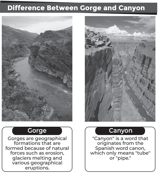
shaped valleys can be categorized into two main types: gorges and canyons.
Gorges
• Gorges are typically formed during the youthful stage of the fluvial cycle of erosion.
• They are created through active downcutting of valleys, often facilitated by mechanisms like pothole drilling.
• The formation of gorges can also be attributed to the recession of waterfalls.
• Many Himalayan rivers have carved out deep and narrow gorges due to their rapid downcutting action.
Canyons
• Canyons are essentially extended versions of gorges, representing longer valleys with similar characteristics.
• These valleys are also deep and narrow but tend to be longer in extent.
• The steepness of canyon walls depends on the geological composition of the rocks.
• Canyons formed in relatively resistant rock formations exhibit steeper valley sides, while those alternating between resistant and soft rocks may have undulating valley sides.
• Examples of famous canyons include the Grand Canyon of the Colorado River in Arizona, USA and the Gandikota Canyon on the Pennar River in Andhra Pradesh, India.
Waterfalls
• Waterfalls are characterized by the vertical descent of water from a considerable height along the longitudinal profile of rivers. They involve a significant volume of water cascading down from an elevated point. Rapids, on the other hand, are smaller in scale compared to waterfalls.
Pot holes
• Pot holes, on the other hand, are small depressions resembling kettles found in the rocky beds of river valleys. Typically cylindrical in shape, these features are commonly observed in coarse-grained rocks like sandstones and granites. Potholes are formed through erosive processes acting on the riverbed, gradually carving out these cylindrical depressions over time.
River Meanders
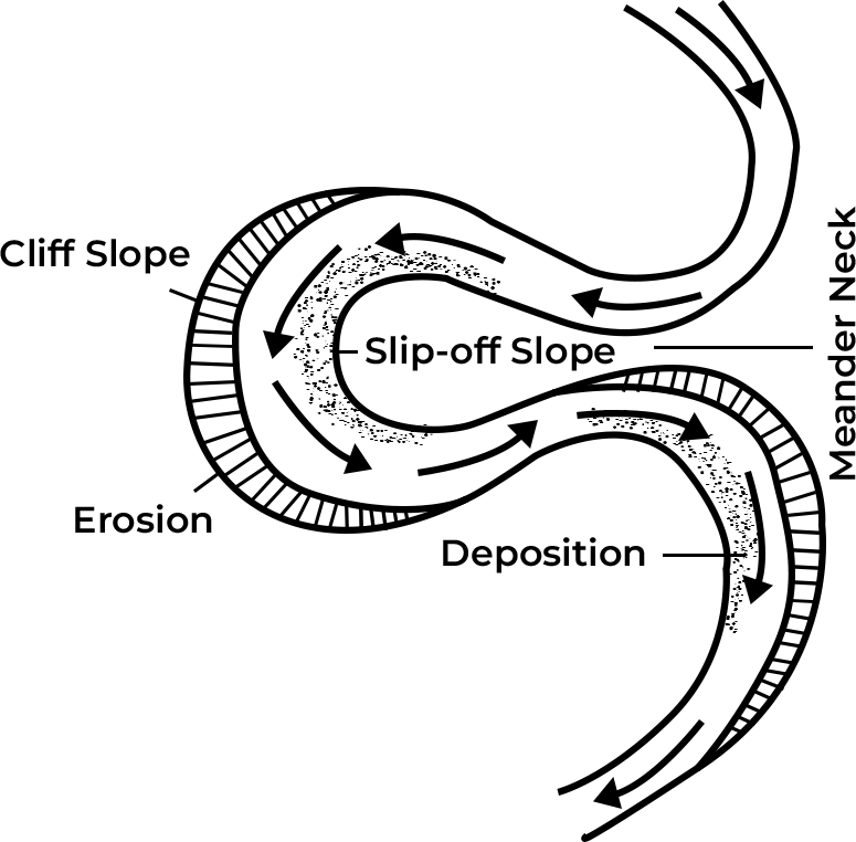
• River meanders are the bends or curves found along the longitudinal courses of rivers. These sinuous bends are referred to as meanders, a term derived from the Meander River in Asia Minor (modern- day Turkey), which is renowned for its numerous bends.
• In a meander, one side is marked by a concave slope, where the river channel directly strikes the valley sides. This concave side experiences intense erosion, leading to the formation of vertical cliffs. This side of the meander belt is often referred to as the cliff-slope side.
• Conversely, the other side of the meander belt features a convex slope, where deposition predominantly occurs, typically comprising sands and gravels. However, occasionally, alluvium may also be deposited. This convex side is characterized by a gentle slope and is known as the slip-off slope side.
Depositional Fluvial Landforms created by Rivers Alluvial fan
• Alluvial fans are geological formations created by the deposition of sediment carried by flowing water.
• Alluvial fans are composed of gravel, sand and other small materials that have been transported and deposited by flowing water.
• When water is confined within a channel, such as a river, and then suddenly exits into an open area, it loses its confinement and spreads out, depositing the sediment it carries. This deposition forms a cone- shaped fan pattern.
• Fan Shape: The term “alluvial fan” originates from the fan-like shape of these formations, as the sediment spreads out in a widening pattern resembling a fan.
• Alluvial fans are typically found in the middle course of rivers, particularly at the base of slopes or mountains where the river exits a confined channel and enters a broader, open area.
Peneplains
• Peneplains are low, featureless plains characterized by an undulating surface and remnants of convexo- concave residual hills. These formations represent the end products of the normal cycle of erosion.
Delta
• Deltas are distinctive landforms formed at the mouths of rivers where they deposit their sediment load into a body of water.
• Deltas are flat, low-lying areas primarily composed of sediments carried by the river and deposited at its mouth.
• Deltas typically form where the river meets a body of water with slower-moving or stagnant currents, such as an ocean, sea, lake, reservoir or estuary. In these areas, the river’s velocity decreases, allowing sediment to settle out and accumulate.
• Deltas often exhibit a triangular shape, with the apex pointing upstream towards the river’s source and the base extending outward into the body of water. This shape results from the combined effects of sediment deposition and the dynamics of water flow at the river mouth.
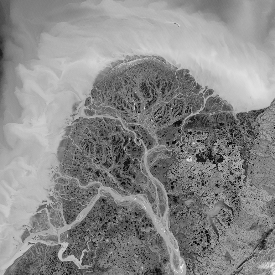
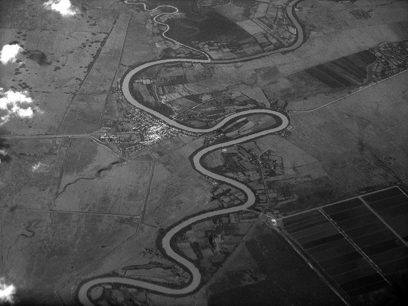
(Fig-Delta) (Fig- Meander)
Oxbow lakes
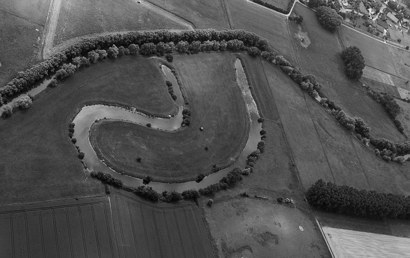
• Oxbow lakes are fascinating features that form as a result of the dynamic processes of erosion and deposition in river meanders.
• As a river flows, it often winds and curves in its path, creating loops known as meanders. The outer banks of these meanders experience erosion due to the faster-flowing water, while sediment is deposited on the inner banks.
• Over time, the outer banks of meanders continue to erode and widen, while the inner banks become more pronounced due to sediment deposition.
•
Eventually, the erosion of the outer banks may cause the meander to become so pronounced that it loops back on itself. During periods of high flow, such as floods, the river may breach the narrow neck of land between the meander loop and the main channel, creating a new, shorter path for the river.
• Once the new path is established, the old meander loop is cut off from the main channel of the river. This isolated body of water is what we call an oxbow lake.
• Horseshoe Shape: Oxbow lakes often exhibit a horseshoe or U-shape, reflecting the curved path of the former meander. They may vary in size from small ponds to large bodies of water, depending on factors such as the size of the river and the rate of sediment deposition.
(fig- Oxbow lake) (Fig- Floodplains)
Floodplains
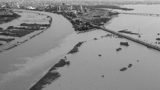
• During periods of high discharge, such as heavy rainfall or snowmelt, rivers may overflow their banks and inundate the surrounding areas. This water spreads out over the adjacent land, forming what is known as a floodplain.
• As the river floods, it carries with it a significant amount of sediment, including sand, silt and clay. When the water spreads out onto the floodplain, its velocity decreases, causing it to deposit this sediment onto the land.
• As the water loses its energy, it drops the sediment it was carrying, leading to the gradual buildup of alluvial deposits.
• Over time, with repeated flooding events, the deposited sediment accumulates, gradually raising the elevation of the floodplain.
Levees
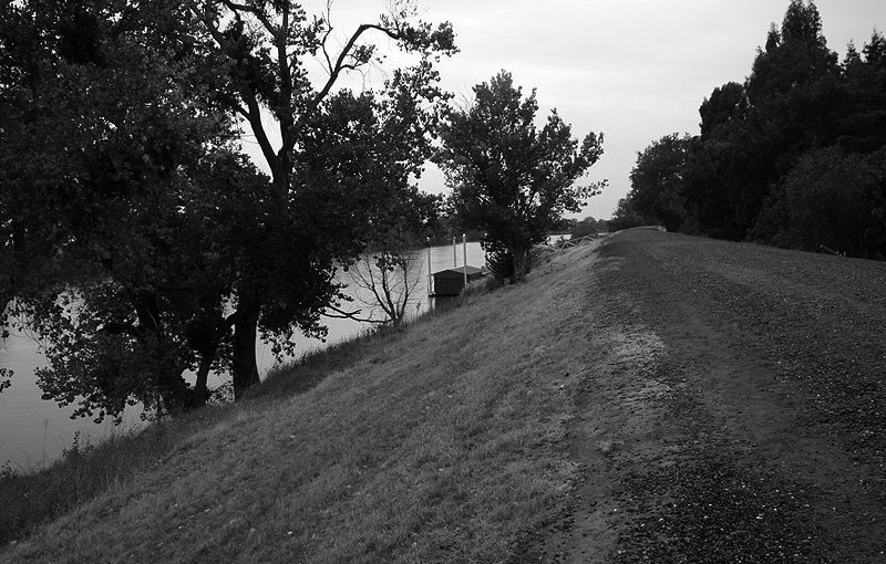
• The formation of levees on floodplains is a natural process that occurs as a result of river flooding and sediment deposition.
• As floodwaters spill out onto the floodplain, the wide expanse of the area causes the water velocity to decrease significantly due to friction with the land surface.
• The reduced velocity of the water leads to the deposition of sediment carried by the floodwaters. Coarser, heavier materials settle out first, closer to the river channel, while finer particles may be carried further away from the river.
• Over time, with repeated flooding events, the coarse sediment deposits accumulate along the banks of the river channel. These deposits gradually build up, forming natural embankments or ridges known as levees. Levees typically have a higher elevation than the surrounding floodplain due to the accumulation of sediment.
(Fig- Levee) (Fig- Braided pattern)
Braided channels
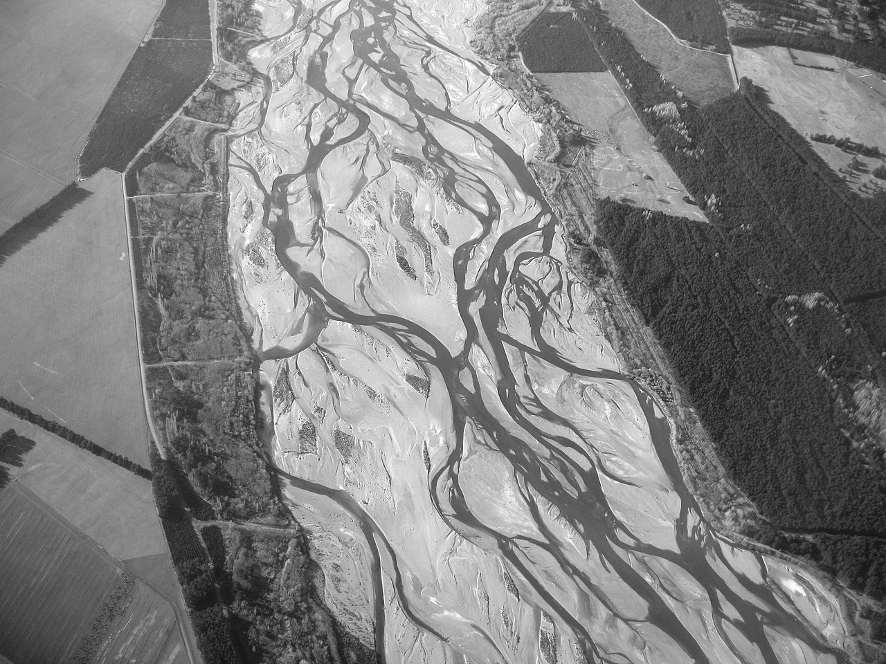
A braided channel or river refers to a river that is characterized by being divided into multiple smaller channels or streams, often resembling a braided pattern. These channels may intertwine and diverge, creating a network of interconnected pathways for the flow of water.
Eyots, also known as aits or islets, are small islands that form within the braided river channels. These islands are typically temporary and are created by the deposition of sediment carried by the river. Eyots contribute to the division of the river into smaller channels and add complexity to its morphology.
Braided channels often form in rivers with specific characteristics. These rivers typically have a steep gradient or profile, allowing for the rapid movement of water and sediment.
Additionally, braided rivers are often rich in sediment, which can be sourced from upstream erosion or sediment inputs from tributaries. Regularly fluctuating discharge, often due to seasonal variations in precipitation or snowmelt, is another characteristic feature of braided rivers.
Estuary & mudflats
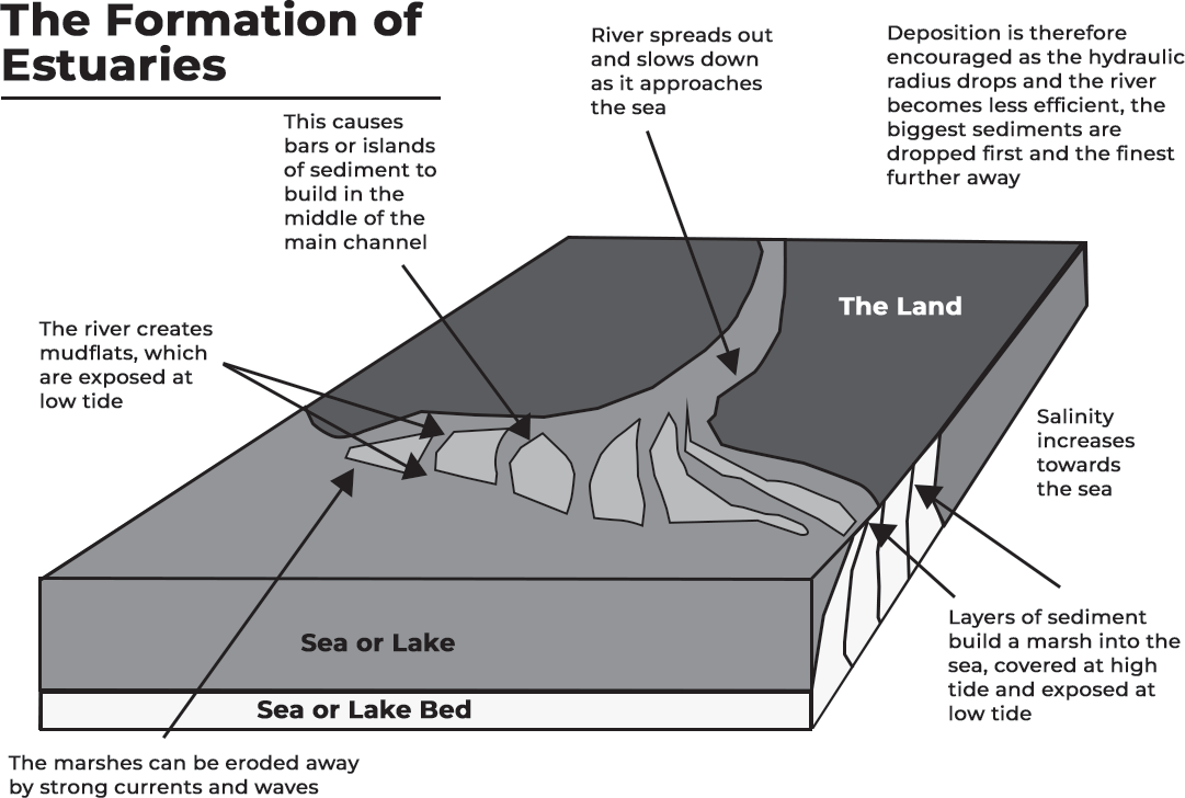
An estuary is a coastal area where a river meets the sea or ocean.
Estuaries form at the interface between freshwater rivers or streams and saline seawater. The mixing of these two water bodies creates a unique brackish water environment characterized by fluctuating salinity levels.
Estuaries are subject to tidal influences, with water levels rising and falling in response to the gravitational pull of the moon and sun. As a result, estuarine ecosystems experience regular fluctuations in water depth and salinity.
Estuaries are highly productive ecosystems that support diverse communities of plants and animals. The mixing of freshwater and saltwater creates dynamic habitats rich in nutrients, making estuaries important breeding grounds, nurseries and feeding areas for many species.
Mudflats are extensive areas of soft, muddy sediment that are exposed at low tide and submerged at high tide. These habitats form in sheltered coastal areas where tidal currents and river flows deposit fine-grained sediment, such as silt and clay. Mudflats are characterized by their flat topography and are often colonized by specialized plants and animals adapted to the fluctuating tidal environment.
KARST TOPOGRAPHY
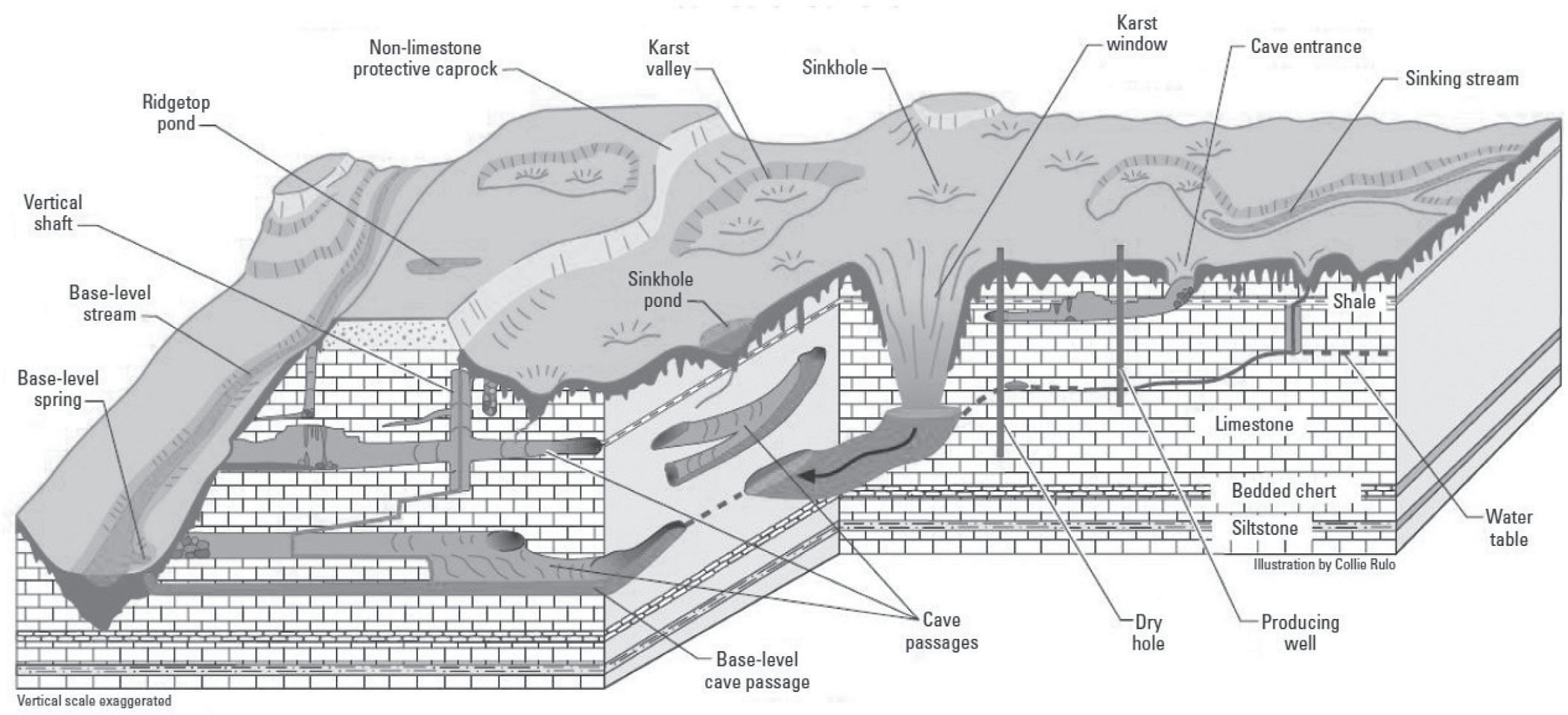
Karst topography, characterized by unique landforms such as sinkholes, caves and underground drainage systems, is the result of the dissolution of soluble rocks like limestone and dolomite by groundwater. This process begins with groundwater percolating through the fractures and pores of the soluble rock. As it flows, the groundwater picks up minerals like calcium carbonate and magnesium carbonate, derived from the dissolution of the rock.
Subsequently, these dissolved minerals are transported by the groundwater and deposited within underground voids, creating intricate cave systems and passages. Over time, as the dissolution process continues, the underground cavities may enlarge and eventually lead to the collapse of the overlying rock layers, forming sinkholes on the surface. This continuous dissolution and deposition cycle sculpt the distinctive landscape features associated with karst topography.
This process can create a variety of landforms
Erosional landforms
Erosional landforms in karst topography are shaped by various processes involving the dissolution of soluble rocks like limestone and dolomite.
• Sinkholes: These are depressions in the ground that occur when the roof of an underground cave collapses. Over time, as soluble rock is dissolved by groundwater, caverns or voids form beneath the surface. When the roof of these caverns can no longer support the weight above, it collapses, creating a sinkhole.
Lapies: Lapies are small grooves or channels that form on the surface of rocks due to the selective dissolution of soluble minerals. As water flows over the surface of the rock, it dissolves the more soluble minerals, leaving behind these distinctive grooves.
Dolines: Dolines are larger depressions in the ground that result from the dissolution of soluble rocks. They are similar to sinkholes but typically larger in scale. Dolines form when underground caverns or voids enlarge due to the dissolution process, causing the surface to collapse and create a depression.
Caves: Caves are underground passages formed by the dissolution of soluble rocks by groundwater. As water percolates through fractures and pores in the rock, it dissolves the minerals, gradually enlarging the passages over time and creating extensive cave systems.
Cenotes: Cenotes are natural pits, sinkholes, or caverns partially or completely filled with water. They often form when the roof of an underground cavern collapses, exposing the groundwater below. Cenotes are common in karst regions and can provide access to underground cave systems.
Depositional landforms
Depositional landforms in karst topography are created by the precipitation of dissolved minerals from groundwater.
Stalactites: These are mineral deposits that hang from the ceiling of a cave. They form as water drips from the cave ceiling, carrying dissolved minerals such as calcium carbonate. As the water evaporates, the minerals are left behind, gradually building up the stalactite from the ceiling downwards.
• Stalagmites: Stalagmites are mineral deposits that rise from the floor of a cave. They form when mineral-rich water drips onto the cave floor and evaporates, leaving behind deposits of minerals. Over time, these deposits accumulate and grow upwards, forming stalagmites.
• Pillars: Pillars are formed when stalactites hanging from the ceiling of a cave and stalagmites rising from the floor grow together and eventually merge into a single column or pillar.
• Flowstone: Flowstone is a mineral deposit that forms on the walls of a cave. It is created by the slow dripping of mineral- rich water over the cave walls. As the water flows down the walls, it deposits layers of minerals, resulting in the formation of smooth, sheet-like structures.
• Travertine: Travertine is a type of limestone formed by the precipitation of dissolved minerals from hot springs. As water flows through limestone-rich areas and reaches the surface as hot springs, it carries dissolved minerals with it. When the water reaches the surface and cools, the minerals are deposited, gradually building up layers of travertine over time. This process often results in the formation of terraces and other distinctive surface features around hot spring areas.
Examples
• Nullarbor Plain, Australia: Known for its expansive flat terrain, the Nullarbor Plain showcases vast stretches of limestone karst landscape, featuring sinkholes, caves, and underground drainage systems.
• Yucatán Peninsula, Mexico: The Yucatán Peninsula is famous for its extensive network of cenotes, natural sinkholes or caverns filled with groundwater. These cenotes are not only geological wonders but also popular swimming and diving destinations, offering stunning underwater landscapes and ecosystems.
• The Burren, Ireland: Characterized by its unique limestone pavements, the Burren in Ireland displays vast expanses of flat, bare rock surfaces interspersed with cracks, crevices, and grikes. This distinctive karst landscape supports a rich diversity of flora, including rare and endemic plant species.
• Guangxi Zhuang Autonomous Region, China: Home to the Shilin karst forest, Guangxi features towering limestone formations known as karst pillars or pinnacles. This karst forest boasts the world’s largest cave system, with expansive underground caverns and passages waiting to be explored.
Dinaric Alps, Southeastern Europe: Stretching across several countries in Southeastern Europe, the Dinaric Alps showcase breathtaking karst landscapes characterized by rugged limestone peaks, deep gorges, and extensive cave systems. This region is renowned for its stunning natural beauty and rich cultural heritage.
LANDFORMS CREATED BY GLACIERS
Glaciers, massive bodies of ice, possess the ability to gradually advance over land, shaping the terrain through a combination of erosion and deposition processes. As glaciers move, they accumulate rocks, gravel and sediment, which they incorporate into their mass. This debris acts like sandpaper, scraping and grinding against the bedrock underneath, leading to the formation of distinct landforms.
Erosional Landforms
Erosional landforms created by glaciers result from the dynamic interplay of ice movement and the abrasive action of debris embedded within the glacier.
Cirques: These are amphitheater-shaped depressions found in mountainous regions, formed by the erosive processes of plucking and abrasion as glacial ice
moves across the landscape. Cirques often contain small lakes, known as tarns, and are typically the starting point for glaciers.
Horns: Horns are distinctive pyramid-shaped peaks formed by the erosion of multiple cirques converging at a central point. Examples include iconic peaks like the Matterhorn in the Alps, characterized by sharp, steep faces carved by the action of glaciers.
U-shaped Valleys and Fjords: U-shaped valleys are trough-like valleys with steep sides and a flat bottom, sculpted by the erosive force of glaciers. Fjords are extensions of these valleys that have been flooded by the sea after glaciers retreated. Glacial erosion carves deep, narrow valleys which, when inundated by rising sea levels, create fjords, notable for their steep cliffs and scenic beauty.
Arêtes: These are narrow, sharp ridges formed by the erosion of adjacent glaciers flowing in opposite directions. Arêtes often separate two glacial valleys and are characterized by their steep sides and jagged peaks.
Truncated Spurs: Truncated spurs are triangular- shaped ridges that were once part of a mountain range but have been cut off or truncated by the erosive action of glaciers. As glaciers move down valleys, they wear away the sides of mountains, leaving behind truncated spurs.
Hanging Valleys: Hanging valleys are smaller valleys perched above the main valley floor, formed by tributary glaciers that have eroded at different rates than the main glacier. When the main glacier deepens the valley, the smaller tributary valleys remain elevated, creating the characteristic “hanging” appearance.
Depositional Landforms
Moraines: These are accumulations of rocks, gravel, and sediment carried and deposited by glaciers. Terminal moraines mark the farthest extent of a glacier’s advance, while lateral and medial moraines form along the sides and within the glacier, respectively, as a result of debris picked up and transported by the moving ice.
Drumlins: Drumlins are elongated, streamlined hills composed of glacial till. They are formed by the movement of glaciers and often indicate the direction of ice flow. Drumlins typically have a steep side facing the direction from which the glacier advanced and a gentler slope on the opposite side.
Eskers: These sinuous ridges are composed of sand and gravel deposited by meltwater streams flowing beneath or within glaciers. Eskers form when sediment-laden meltwater is deposited in tunnels or channels beneath the ice, creating long, winding ridges upon the glacier’s retreat.
Outwash Plains: Outwash plains are extensive flat areas covered with sand and gravel deposited by meltwater streams flowing away from glaciers. The sediments on these plains are sorted and stratified according to size due to the sorting action of glacial meltwater.
Till Plains: Till plains are flat, gently sloping surfaces covered with a thick layer of glacial till, a mixture of unsorted sediments deposited directly by glaciers as they retreat. These plains often exhibit low relief and are characteristic of regions formerly covered by ice sheets.
Kettle Lakes: These depressions are formed when blocks of ice, known as kettle holes, are left behind by retreating glaciers. As the ice blocks melt, they create small, often circular lakes. Kettle lakes are common in areas where glaciers have deposited large amounts of sediment, creating depressions in the landscape
LANDFORMS CREATED BY WAVES AND OCEAN CURRENTS
Sea Stac k
Waves and currents play pivotal roles in shaping coastal landscapes through erosion, transportation and deposition of sediment.
Erosional Landforms
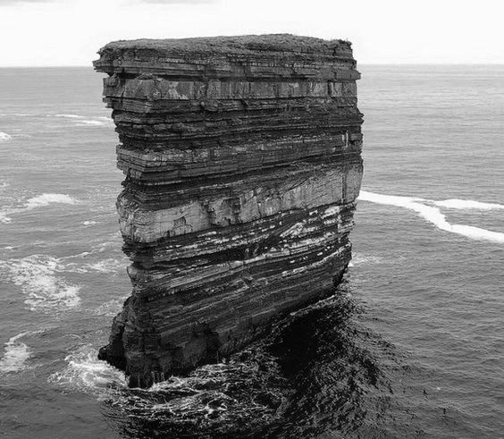
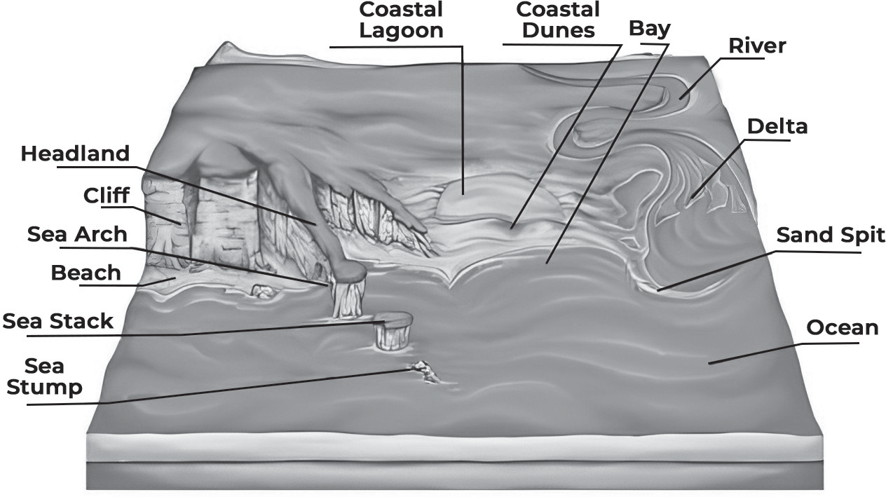
Sea stacks: These are isolated rock pillars that stand offshore, formed by the relentless erosion of waves and currents on coastal cliffs. Over time, the erosive action of waves wears away softer rock layers, leaving behind resistant portions as tall pillars or stacks.
Caves: Natural openings or hollow spaces in coastal cliffs created by the erosive force of waves. As waves repeatedly crash against the base of cliffs, they exploit weaknesses in the rock, gradually enlarging cracks and fissures to form caves.
Arches: Arches are formed when caves near the base of cliffs are eroded to the extent that their roofs collapse, leaving behind natural bridges or arches of rock. The continual action of waves and weathering weakens the roof of the cave until it eventually collapses, forming an arch.
Wave-cut platforms: These are flat, sloping surfaces of rock extending from the base of coastal cliffs into the sea, formed by the erosive action of waves. As waves break against the cliff face, they dislodge and transport rock fragments, gradually wearing down the base of the cliff to create a broad, flat platform.
Depositional Landforms
Depositional landforms along coastlines are formed by the deposition of sediment carried by waves and currents.
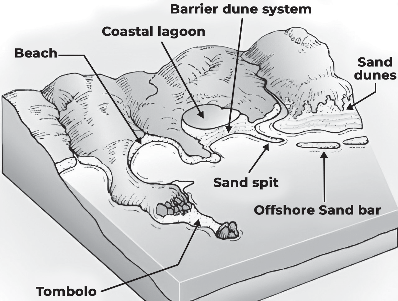
• Beaches: Beaches are accumulations of sand, gravel, or pebbles deposited along the shoreline by the action of waves and currents. They typically form in areas where sediment is transported and deposited by wave action, creating a gently sloping area between the land and the water.
• Spits: These are narrow, elongated landforms that extend from the shore out into the sea. Spits are formed by the deposition of sediment carried by longshore drift, where waves approach the shore at an angle and carry sediment along the coast. Over time, this sediment accumulates, forming a spit that protrudes into the sea.
• Tombolos: Tombolos are similar to spits but connect an island to the mainland. They are formed when sediment is deposited between the island and the mainland, eventually creating a land bridge or isthmus.
• Sand Bars: Sand bars are offshore ridges or bars of sand, gravel, or pebbles that are created by the deposition of sediment. They typically form parallel to the shoreline and can be submerged or exposed depending on the tide. Sand bars play a crucial role in coastal dynamics and can influence wave action and sediment transport.
• Lagoons: Lagoons are shallow, sheltered bodies of water separated from the open sea by a barrier, such as a sand bar or spit. They are often found behind barrier islands or along coastlines with extensive depositional features. Lagoons can support diverse ecosystems and provide important habitats for marine life.
AEOLIAN LANDFORMS
Aeolian landforms are those that are formed or influenced by the action of wind. Wind plays a crucial role in shaping the Earth’s surface, especially in arid and semi-arid regions where vegetation is limited and soil is loose. Through processes of erosion, transportation, and deposition, wind can create a diverse range of landforms known as aeolian landforms.
Erosional Landforms
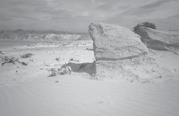
Erosional landforms shaped by wind action are the result of the abrasive forces exerted by wind-blown particles on the Earth’s surface.
Deflation Hollows: These are shallow depressions on the land surface caused by the deflation or removal of loose sediment by wind. Deflation hollows typically occur in areas with minimal vegetation and loose soil or sediment, where wind erosion is prevalent.
Yardang
Yardangs: Yardangs are elongated, streamlined landforms formed by the erosion of softer sedimentary rocks by wind-blown sand and abrasion. These ridges or grooves are aligned parallel to the prevailing wind direction and are often found in regions with strong winds and hard rock formations.
Blowouts: Blowouts are areas of wind-deflated terrain where layers of soil and underlying rock have been eroded, leaving behind depressions or pits. They are often surrounded by hummocks or dunes formed by the deposition of wind-blown sediment. Blowouts can vary in size and shape and are characteristic features of landscapes affected by wind erosion.
• Ventifacts: These are rocks that have been shaped and polished by the abrasive action of wind-driven sand. Ventifacts often exhibit smooth, faceted surfaces and may have distinctive features such as grooves or fluting caused by the selective erosion of softer layers within the rock. They are commonly found in desert regions where wind erosion is prevalent.
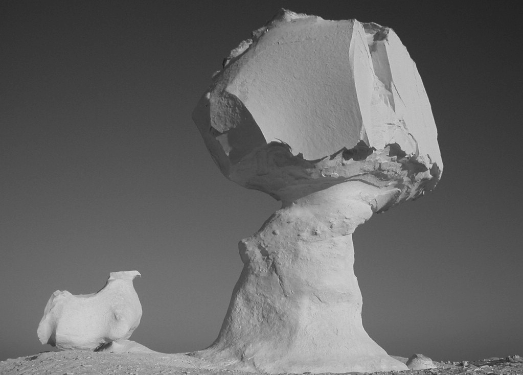
Ventifact
Depositional landforms
Depositional landforms shaped by wind-driven processes involve the accumulation and redistribution of sediment across the landscape.
Sand dunes: Sand dunes are accumulations of windblown sand that form various shapes and sizes depending on wind direction, sediment availability, and local topography. Different types of sand dunes include
• Barchan dunes: Crescent-shaped dunes with steep slip faces on the convex side and gentler slopes on the concave side. They typically migrate across the landscape as wind direction changes.
• Seif dunes: Long, sinuous ridges of sand aligned parallel to the prevailing wind direction. They are often found in areas with abundant sand supply and strong, unidirectional winds.
• Parabolic dunes: Similar to barchan dunes but with elongated arms or spurs extending downwind from the dune peak. They are common in areas with variable wind directions or where vegetation interferes with sand movement.
• Transverse dunes: Linear ridges of sand oriented perpendicular to the prevailing wind direction. They often form perpendicular to other dunes or obstacles, such as vegetation or topographic features.
• Longitudinal dunes: Elongated ridges of sand that extend parallel to the prevailing wind direction. They are typically found in areas with abundant sand supply and strong, unidirectional winds.
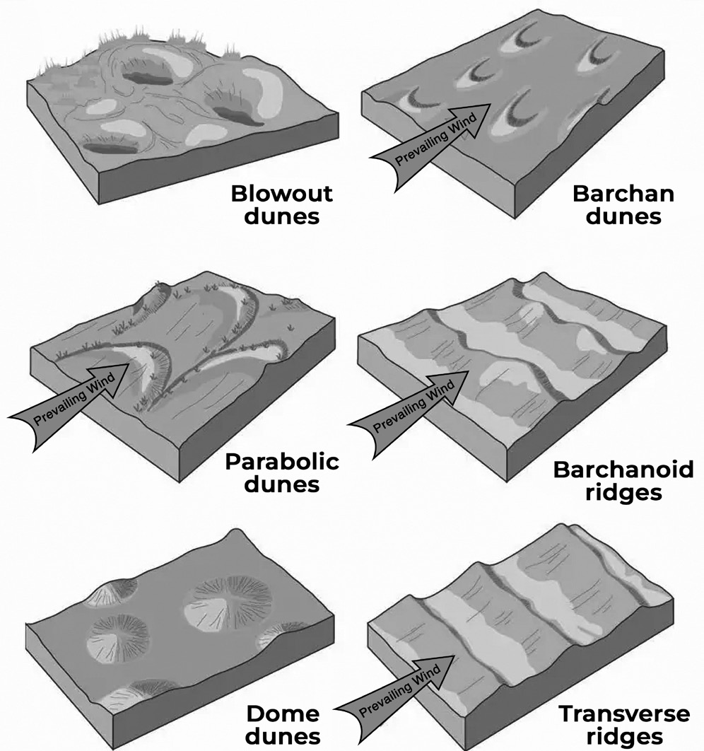
Depositional Landforms
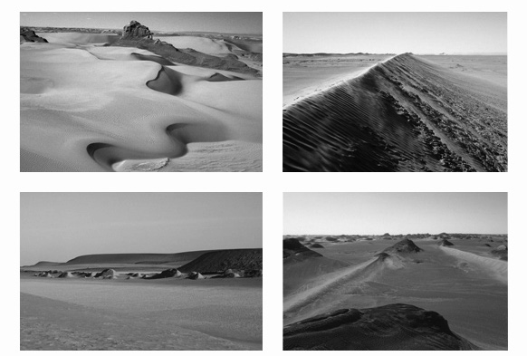
Transverse Dunes
Loess deposits: Loess deposits are thick layers of windblown silt particles, often found in areas downwind of glaciated terrains or regions with extensive river valleys. Loess deposits contribute to fertile soils and can form extensive landscapes with unique features.
Desert varnish: Desert varnish is a thin, dark coating of iron and manganese oxides that forms on rocks in arid regions. It acts as a protective layer against wind erosion and can provide valuable information about past environmental conditions.
Playas: Playas are flat, dry lake beds found in arid regions, often formed by the wind removing water through evaporation. They can undergo periodic flooding during rare rain events, leaving behind characteristic sediment patterns.
Sand sheets: Sand sheets are extensive, flat deposits of wind- blown sand covering large areas. They often form in regions with sparse vegetation and are shaped by prevailing wind patterns