Evaporation
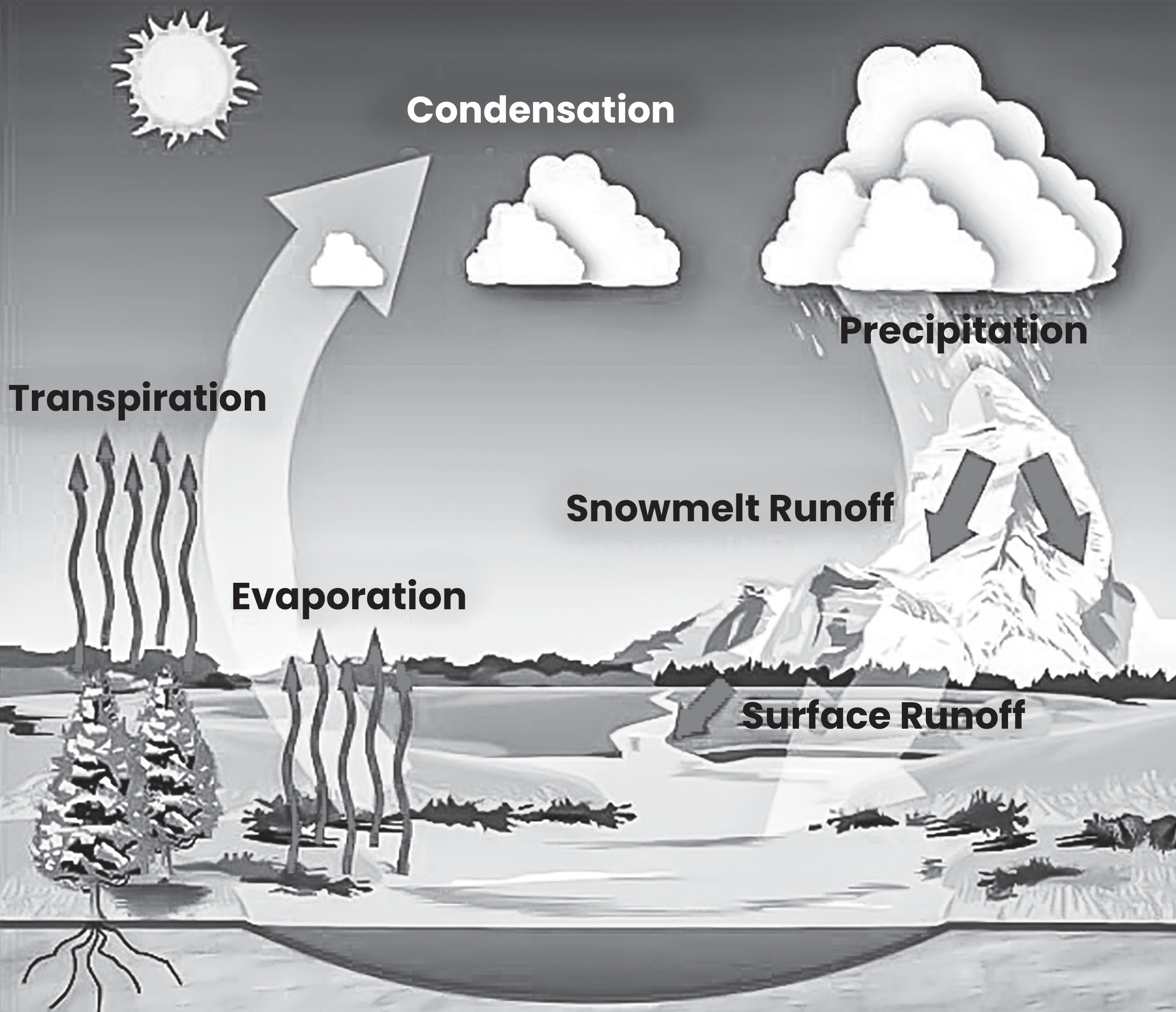
The water cycle elaborates how water moves through Earth’s land, ocean, and atmosphere. Water exists in various forms and locations, including as liquid in lakes and rivers, solid in glaciers and ice sheets and vapor in the air and clouds. The water cycle comprises three primary processes: evaporation, condensation and precipitation.
EVAPORATION
Evaporation is defined as the process where a liquid’s surface changes to a gas. In the water cycle, water from oceans, lakes, and rivers evaporates and transforms into water vapor, which is an essential component of the air we breathe. Water vapor also acts as a significant greenhouse gas.
The primary driving force behind the evaporation process is the energy of the sun which interacts with liquid water on the Earth’s surface, causing it to transition into an invisible gas (water vapor).
Additionally, factors such as wind, temperature, and the density of the body of water influence the rate of evaporation.
Factors Affecting Evaporation Rate
Surface Area: The larger the surface area of the water body, the higher the rate of evaporation, and vice versa.
Temperature: Higher temperatures lead to increased kinetic energy of water molecules, resulting in higher rates of evaporation.
Humidity: The presence of high humidity in the atmosphere reduces the rate of evaporation, as the air already contains a significant amount of water vapor.
Wind Speed: Higher wind speeds enhance the rate of evaporation by continually removing water vapor from the surface, thus maintaining a concentration gradient favoring evaporation.
can condense to form liquid droplets. These nuclei can include dust, pollutants, salt particles, or even microscopic organisms.
Condensation
CONDENSATION
Condensation is the process by which water vapor changes from a gaseous state to a liquid state. When air is cooled below its dew point temperature, some of the water vapor in the air undergoes condensation, forming liquid water droplets.
Pre-Requisite Conditions for Condensation
There must be a significant amount of water vapor present in the air for condensation to occur. This water vapor can originate from sources such as evaporation from bodies of water or transpiration from plants.
The air needs to reach a state of saturation, where it contains the maximum amount of water vapor that it can hold at a given temperature. Saturation can be achieved by either cooling the air to its dew point temperature or by adding more water vapor to it.
Condensation nuclei are tiny particles suspended in the air that serve as surfaces on which water vapor
can condense to form liquid droplets. These nuclei can include dust, pollutants, salt particles, or even microscopic organisms.
There are four important processes under which air cools below its dew point
Loss of heat by radiation,
Contact with cold surfaces such as cool ground, leaves of plants, layers of snow and icebergs,
Mixing with cold air, and
No actual addition or withdrawal of heat. This type of temperature changes result from internal processes in adiabatic change e.g. adiabatic cooling by expansion in rising air current.
Adiabatic Process of Cooling
An adiabatic process occurs when no heat is added to or subtracted from an air mass as it moves vertically in the atmosphere. Air, being a poor conductor of heat, retains its heat energy when it moves vertically, maintaining its thermal identity different from the surrounding air.
When an air mass rises in the atmosphere, it expands due to the decrease in pressure at higher elevations. As the air mass expands, it performs work against the surrounding air, resulting in the consumption of internal heat energy.
The rate at which the temperature of a moving air mass decreases with height is called the adiabatic lapse rate (ALR).
When an air mass remains dry (i.e., no condensation occurs), the rate of temperature decrease is known as the dry adiabatic lapse rate (DALR). The typical value of the DALR is approximately 10 C per kilometer of ascent. It represents the rate of temperature change for dry air undergoing adiabatic expansion.
The environmental lapse rate refers to the actual rate of temperature change with height as observed in the atmosphere. It is measured using instruments such as thermometers carried by balloons through the atmosphere.
The DALR differs from the environmental lapse rate, providing important insights into the vertical temperature structure of the atmosphere.
• As a rising air mass continues to ascend in the atmosphere, its temperature decreases due to adiabatic expansion. Eventually, the air mass may reach a point where its temperature cools to the dew point temperature, causing it to become saturated with water vapor. Further cooling beyond the dew point leads to condensation, wherein water vapor molecules transition into liquid water droplets.
During condensation, latent heat of condensation is released, which is the heat energy absorbed or released during a phase change. This latent heat of condensation is added to the rising air mass, contributing to its warming and slowing down the rate of cooling.
• The rate at which the temperature of a saturated air mass decreases with height is known as the saturated adiabatic lapse rate (SALR). Unlike the dry adiabatic lapse rate (DALR), which assumes no condensation, the SALR accounts for the release of latent heat during condensation. The SALR is typically lower than the DALR, reflecting the slower rate of cooling due to the addition of latent heat. Its value generally ranges around 5 C per kilometer of ascent, but it can vary depending on factors such as humidity and atmospheric conditions.
• Condensation depends on two main variables: the amount of cooling experienced by the air mass and the relative humidity of the air.
Types of Condensation
Various forms of condensation near the ground and the conditions favorable for their formation:
Dew
Dew forms directly by condensation near the ground when surfaces are cooled by outgoing radiation.
Favorable conditions for dew formation include radiational cooling during the night, calm conditions or light winds, clear skies, cool and long nights, sufficient availability of water vapors, anticyclone wind and cold advection.
Fog
Fog results from the condensation of atmospheric water vapors into water droplets suspended in the air, reducing surface visibility.
Favorable conditions for fog formation include excessive moisture with relative humidity greater than 75%, calm or light winds and anticyclonic winds.
Frost
Frost occurs when the dew point of the air falls below the freezing point (0 C), leading to the direct sublimation of water vapors into solid ice crystals.
Frost may be light or heavy, with heavy frost causing damage to crops, also known as killing frost.
Frosty nights are common during the winter season in northwest India, causing damage to crops sensitive to low temperatures.
Smog
Smog is a combination of fog and smoke, often found over industrial cities in middle or high latitudes. It can persist for
days and is associated with health hazards and increased mortality rates, earning it the name “killer fog.”
Cloud Formation
Cloud formation occurs through the process of evaporation followed by condensation, where water on the Earth’s surface evaporates due to sunlight and rises into the atmosphere.
Upon reaching a certain height, water vapor condenses to form tiny droplets, which collect to form clouds that float in the air.
The level at which condensation occurs determines cloud formation, mist, fog and dew. This condensation level decreases from the equator towards the poles.
Precipitation
PRECIPITATION
Precipitation refers to any form of liquid or solid water that falls on the Earth’s surface as a result of condensation in the atmosphere. Types of precipitation include rain, snow, and hail. Precipitation plays a vital role in the water cycle, as it represents one of the mechanisms by which water is cycled from the atmosphere back to the Earth or ocean.
Besides evaporation, condensation, and precipitation, there are additional processes involved in the water cycle. These processes include runoff, which is the flow of water over the land surface into rivers, lakes, and oceans, and transpiration, which is the release of water vapor from plants into the atmosphere.
Evapotranspiration is a combined term that encompasses both evaporation and transpiration. It represents the total movement of water from the Earth’s surface to the atmosphere.
There are three main types of rainfall — convectional rainfall, orographic rainfall and cyclonic rainfall.
Convectional Rainfall
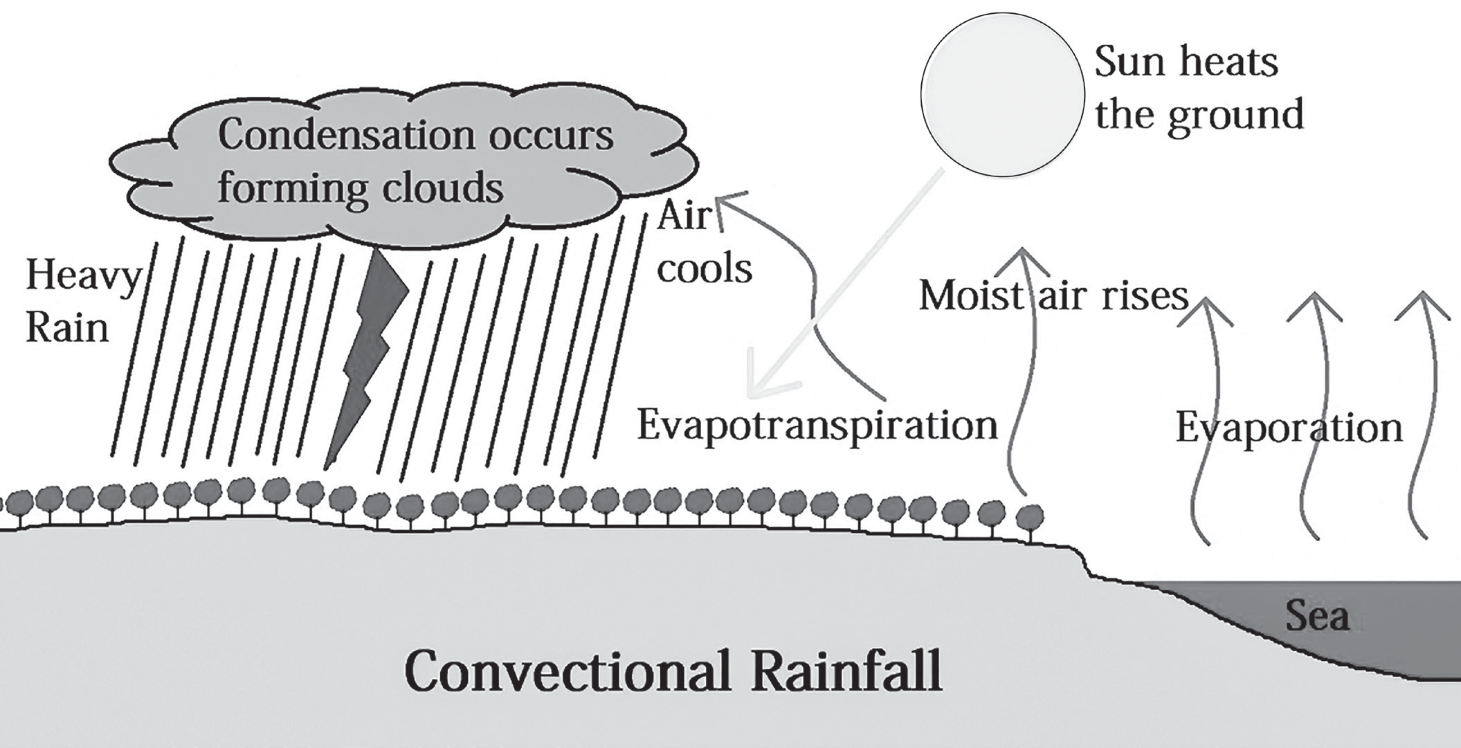
Convectional rainfall predominantly occurs in equatorial regions due to the high temperatures prevalent in these
areas, leading to a high rate of evaporation. The equatorial regions experience consistently warm temperatures throughout the year, creating ideal conditions for convectional rainfall.
High temperatures cause the air near the surface to become heated, leading to its expansion and rise into the atmosphere. As warm air ascends, it expands and cools at higher altitudes, resulting in the condensation of water vapor and the formation of cumulonimbus clouds
with significant vertical extent. These cumulonimbus clouds are characterized by towering structures and are associated with intense convection and updrafts.
Such clouds often produce heavy rainfall, accompanied by thunder and lightning due to the vigorous convective activity within the clouds.
The Amazon River basin, located in the equatorial region, experiences convectional rainfall almost daily.
Orographic or Relief Rainfall
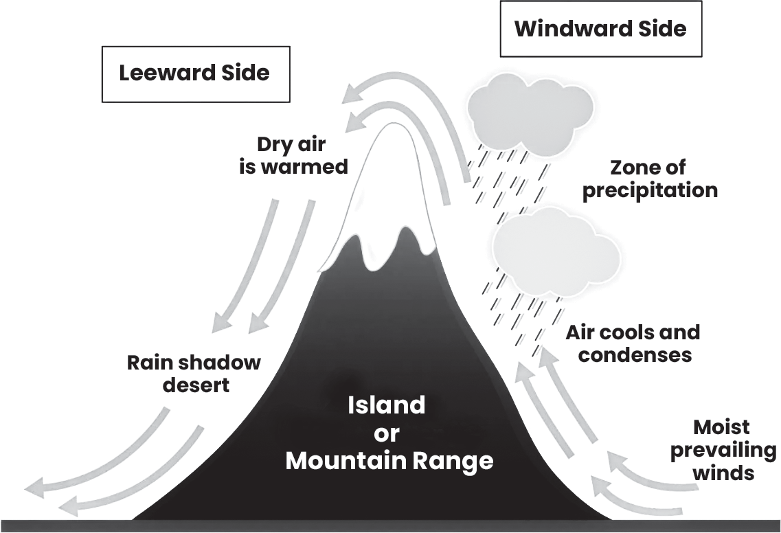
Relief rainfall is named as such because it is influenced by the relief or physical features of a region, particularly mountains. When moisture-laden winds encounter a mountain range, they are forced to ascend due to the barrier created by the mountains.
As the air rises along the mountain slope, it undergoes adiabatic cooling and reaches its saturation point, leading to condensation and the formation of clouds. The condensed moisture then precipitates as rainfall on the windward side of the mountains.
On the windward side of the mountains, where the moist air ascends and cools, heavy rainfall occurs due to the condensation of water vapor. On the other hand, on the leeward side (or the downwind side) of the mountains, the air descends and warms up, resulting in adiabatic warming and a decrease in relative humidity. This leads to dry conditions and scanty rainfall on the leeward side.
Example: Mumbai, located on the windward side of the Western Ghats, receives heavy rainfall due to relief effects, whereas Pune, situated on the leeward side, experiences relatively lower rainfall amounts.
(Fig-Orographic rainfall)
Cyclonic or Frontal Rainfall
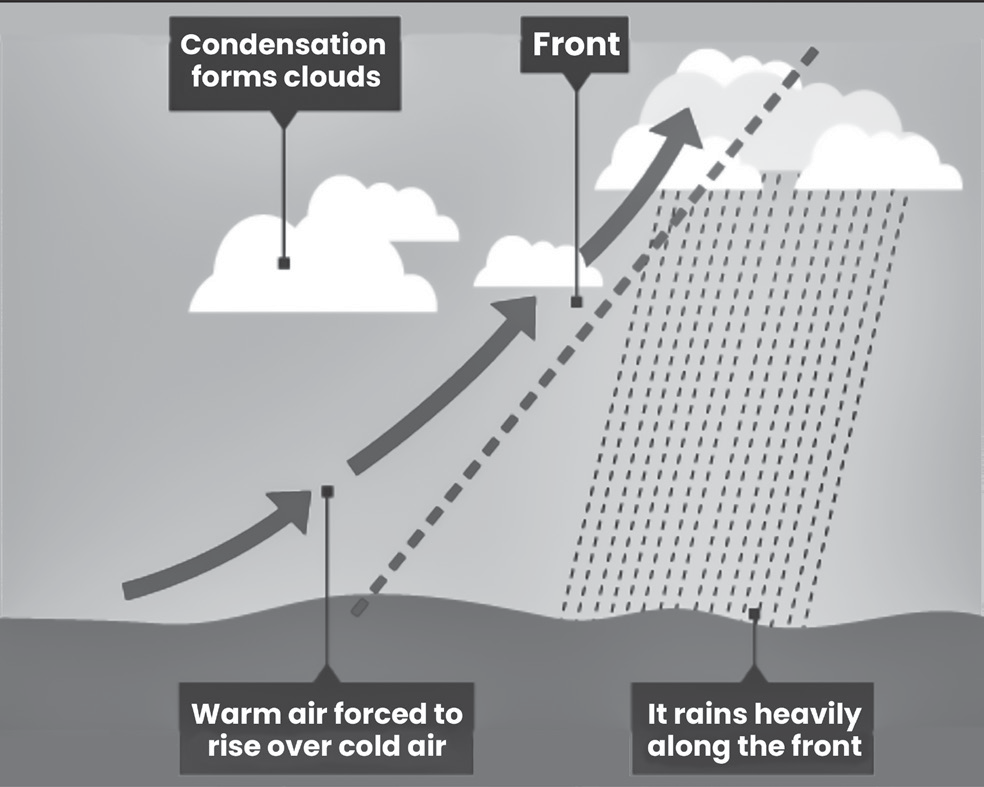
Cyclonic or frontal rainfall occurs when warm air masses and cold air masses converge and interact with each other.
When warm and cold air masses meet, the warmer air, being less dense, rises above the denser, colder air. As
the warm air rises, it undergoes adiabatic cooling and reaches its saturation point, leading to the formation of clouds and subsequent rainfall.
Cyclonic or frontal rainfall events typically last for a few hours. These rainfall events can be very intense, particularly during tropical cyclones or other weather systems characterized by strong temperature gradients and atmospheric instability.
Thunderstorm
THUNDERSTORM
A thunderstorm is a weather phenomenon characterized by rain showers accompanied by thunder. Thunder is caused by lightning, so all thunderstorms inherently involve lightning.
Thunderstorms are typically generated by surface heating, which leads to convection—an upward atmospheric motion that transports moisture along with it. Convection plays a key role in the formation of thunderstorms.
A thunderstorm is classified as “severe” if it exhibits one or more of the following characteristics: hail with a diameter of one inch or greater, winds gusting over 50 knots (equivalent to 57.5 mph), or the presence of a tornado.
Thunderstorms are most likely to occur during the spring and summer months, particularly in the afternoon and evening hours when surface heating is at its peak. However, thunderstorms can happen year-round and at any time of the day or night.
In the Plains region, thunderstorms are particularly common in the late afternoon and nighttime hours due to specific atmospheric conditions prevalent in that area.
Formation of Thunderstorm
Three essential ingredients are required for a thunderstorm to form: moisture, rising unstable air, and a lifting mechanism to initiate upward motion. Cumulonimbus clouds, commonly known as thunderheads, are associated with thunderstorms.
The sun heats the Earth’s surface, warming the air above it. When warm surface air is forced to rise due to factors like topography or air mass interactions, it continues to rise if it remains warmer and less dense than the surrounding air.
As the warm air rises, it transfers heat from the Earth’s surface to higher atmospheric levels through convection. The water vapor contained in the rising air cools, condenses and forms clouds.
The cloud continues to grow upward into regions of the atmosphere where temperatures are below freezing, leading to the formation of ice particles.
Within the thunderstorm cloud, various types of ice particles form from freezing liquid droplets. These ice particles can grow by condensing water vapor or by collecting smaller supercooled liquid droplets.
When ice particles collide, they can exchange electric charges. Accumulation of electric charges within the cloud can lead to the formation of lightning bolts, which generate the sound waves perceived as thunder.
Life Cycle of the Thunderstorm
Thunderstorms have three stages in their life cycle
The developing stage,
The mature stage and
The dissipating stage,
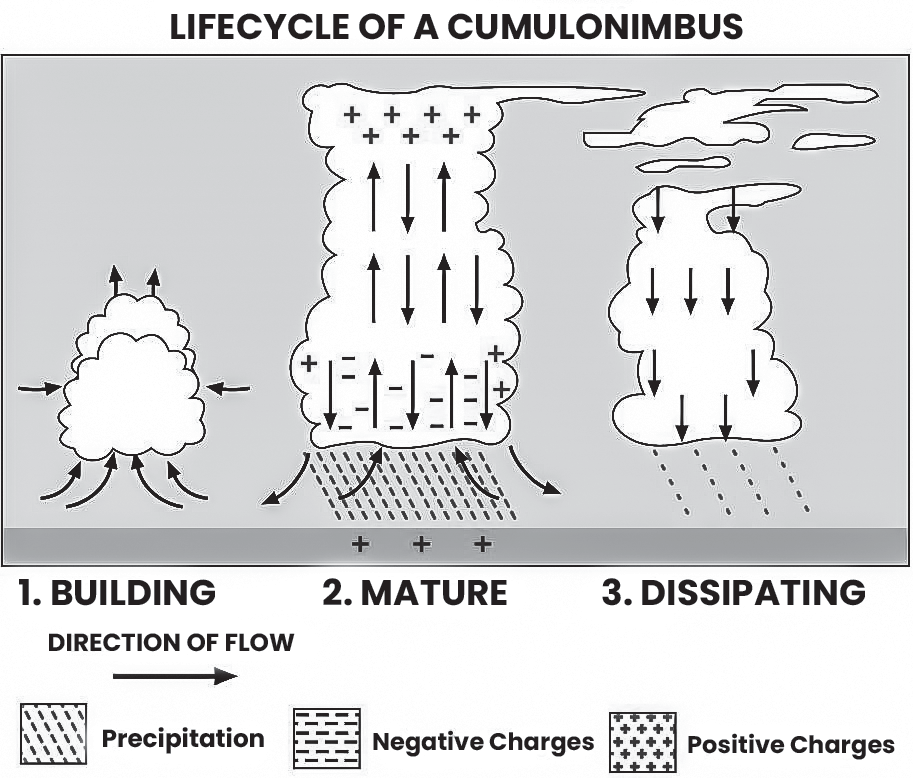
(Fig- Life cycle of a thunderstorm)
The developing or cumulus stage
This stage is characterized by a cumulus cloud being pushed upward by a rising column of air, known as an updraft.
The cumulus cloud starts to resemble a tower, known as towering cumulus, as the updraft continues to strengthen.
During this stage, there is typically little to no rain, but occasional lightning may occur.
The mature stage
The thunderstorm progresses to the mature stage when the updraft sustains the storm, but precipitation begins to fall out of the cloud, leading to the formation of a downdraft.
The downdraft, along with rain-cooled air, spreads out along the ground, forming a gust front characterized by gusty winds.
The mature stage is associated with the most severe weather phenomena, including hail, heavy rain, frequent lightning, strong winds and tornadoes.
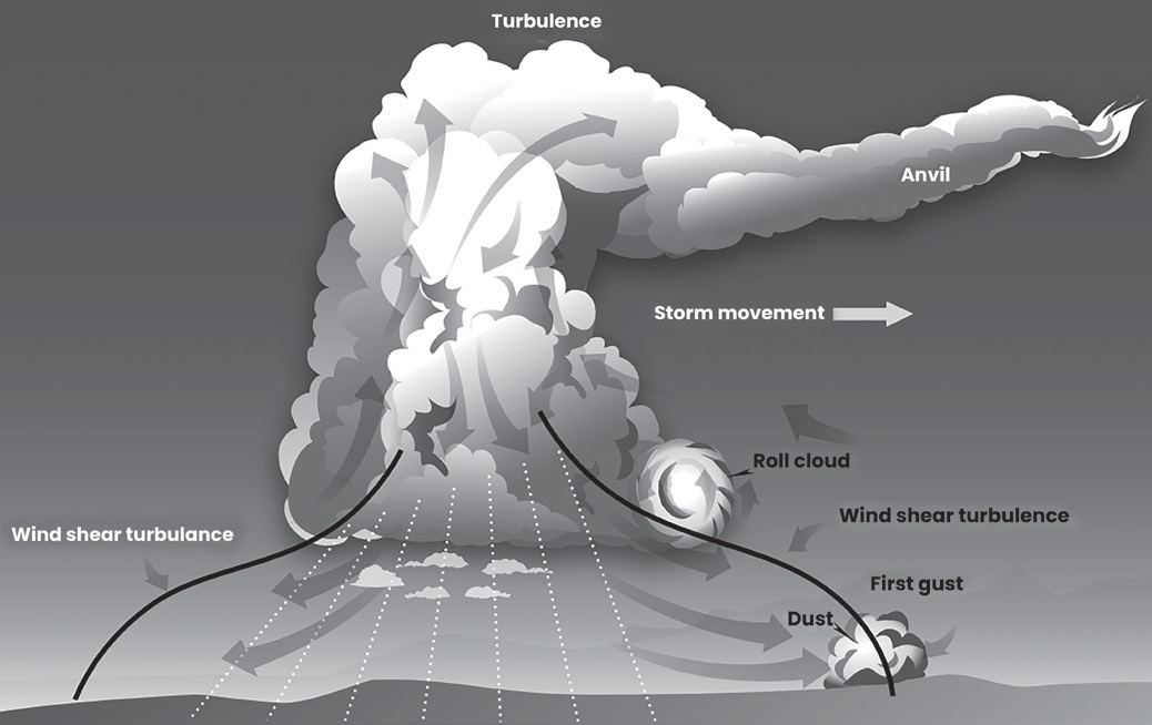
(Fig- Mature stage thunderstorm)
Dissipating Stage
In this stage, the updraft is overwhelmed by the downdraft, marking the beginning of the dissipating stage (Downdrafts within the cloud become stronger than the updrafts, leading to a decline in storm activity).
At ground level, the gust front moves away from the storm, cutting off the warm, moist air that was fueling the thunderstorm.
Rainfall intensity decreases during this stage, but the risk of lightning persists.
There are 4 types of Thunderstorms
• The single-cell
• The multi-cell
• The squall line
• The supercell
The single-cell
Also known as “popcorn” or “pop-up” storms, single- cell thunderstorms are small, brief, and weak storms that typically last for about an hour.
They are driven by heating on a summer afternoon and may produce brief heavy rain and lightning.
These storms are common in spring and summer and can provide relief from intense heat.
The multi-cell
Multi-cell thunderstorms consist of a group or family of single cells at various stages of their life cycles.
New updrafts form along the leading edge of rain-cooled air, known as the gust front.
These storms may produce hail, strong winds, brief tornadoes and flooding.
They can also line up and move continuously over the same area, causing flash flooding through a process called “training.”
The squall line
Squall line storms are intense lines of thunderstorms that can span hundreds of miles.
They consist of a group of storms arranged in a line, often accompanied by squalls of high wind and heavy rain.
Squall lines tend to pass quickly and are less likely to produce tornadoes compared to supercells. They can cause structural damage and are often investigated to determine if the damage was caused by a tornado or a “derecho.”
A supercell
Supercells are long-lived storms, often lasting for more than an hour. They are highly organized, with distinct features such as a rotating updraft and a well-defined structure.
Supercells are fueled by a strong updraft, which is a rising current of air. The updraft in a supercell is tilted and rotating, creating a rotating column of air that extends high into the atmosphere. This rotating updraft can be as large as 10 miles in diameter and reach heights of up to 50,000 feet.
The rotation within a supercell, known as a mesocyclone,
is a key characteristic detected by Doppler radar.
The tornado is a small extension of the larger rotation within the supercell. Most large and violent tornadoes originate from supercells, as the strong rotation and updraft within these storms provide favorable conditions for tornado development.
Destruction by Thunderstorm
Thunderstorms pose various hazards that can endanger lives and property. Heavy rainfall from thunderstorms can lead to flash flooding, which is a rapid and localized flooding of low-lying areas, streets and streams. Flash flooding is one of the leading causes of death associated with thunderstorms due to its sudden onset and swift- moving water.
Lightning is produced by every thunderstorm and poses a significant threat to life and property. On average, lightning causes 80 fatalities and 300 injuries each year in the United States alone. Lightning strikes can start fires, damage electrical equipment and electrocute humans and livestock.
Thunderstorms can generate high winds capable of causing widespread damage. These winds can damage homes, vehicles, trees, and power lines, leading to power outages and property destruction.
Hailstones, which are balls of ice formed within thunderstorms, can cause extensive damage to crops, vehicles, roofs and windows. Large hailstones can injure people and animals caught outdoors during a storm.
Tornado
TORNADO
A tornado is a destructive weather phenomenon characterized by a violently rotating column of air that extends from the base of a thunderstorm to the ground. Tornadoes are capable of causing severe damage to structures, uprooting trees, and propelling debris through the air at high speeds, posing a significant risk to life and property.
Tornadoes can occur at any time of the day or night and during any season of the year. While tornadoes are most common in regions known as “Tornado Alley” in the Central Plains of the United States and the southeastern U.S., they can occur in many other parts of the world as well.
Development of Tornadoes
Thunderstorms form through a complex interplay of atmospheric conditions, typically Factual error - when warm and humid air is forced to rise over cold and dry air. This process leads to the development of convective currents, which create an updraft within the storm.
Convective currents are circular flows of heat that occur in fluids due to difference in temperature and density. These currents are a key driver of weather pattern, ocean currents and movement of tectonic plates.
When warm, moist air rises through the colder, drier air above, it creates an updraft within the thunderstorm. This updraft is driven by the temperature and moisture differences between the two air masses.
In some cases, the winds within a thunderstorm may vary significantly in speed or direction, leading to the development of a rotating updraft. This rotation may be initiated by wind shear or other atmospheric dynamics.
As the rotating updraft intensifies, it can draw in more warm air from the surrounding environment, causing the rotation to become more pronounced. Eventually, this rotation may extend downward from the cloud base, forming a funnel cloud. Initially, this funnel cloud may not reach the ground and is not yet classified as a tornado.
The most violent tornadoes typically originate from supercell thunderstorms, which are large, organized thunderstorms with rotating updrafts. Supercells provide the ideal conditions for tornado formation due to their strong and persistent updrafts.
Within a supercell, the rotating updraft can become increasingly intense, leading to the formation of a tornado. The tornado descends from the base of the thunderstorm and may extend all the way to the ground. Tornadoes are most dangerous when they make contact with the ground, causing widespread destruction.
While tornadoes can form from various types of thunderstorms, including supercells, not all thunderstorms produce tornadoes. Approximately one in a thousand thunderstorms develops into a supercell and only a fraction of supercells produce tornadoes—around one in five or six.
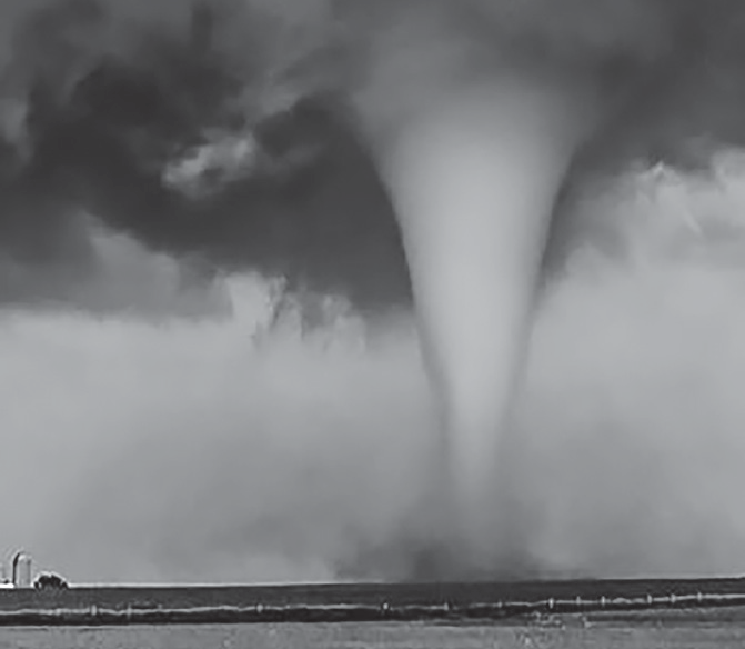
(Fig- Thunderstorm)
Waterspouts
WATERSPOUTS
A waterspout is a meteorological phenomenon characterized by a rotating column of cloud-filled wind extending from a cumulus cloud down to the surface of a body of water, such as an ocean or a lake. Waterspouts are akin to tornadoes but typically exhibit smaller dimensions and less intensity.
There are two main categories of waterspouts: Fair Weather Waterspouts and Tornadic Waterspouts.
Fair weather waterspouts
Fair weather waterspouts are a type of waterspout that typically forms under relatively calm and fair-weather conditions, often in association with developing cumulus clouds.
Unlike tornadic waterspouts, fair weather waterspouts are not associated with thunderstorms or severe weather. They can form in relatively benign weather conditions.
Fair weather waterspouts originate on the surface of the water, as opposed to descending from the base of a thunderstorm cloud. They then work their way upward as they develop.
By the time the funnel of a fair-weather waterspout becomes visible, the waterspout is typically near maturity. This means that observers may not notice the waterspout until it has already formed and developed significantly.
Fair weather waterspouts typically form in light wind conditions, resulting in minimal movement. As a result, they may remain stationary or move very slowly over the surface of the water.
Tornadic waterspouts
Unlike fair weather waterspouts, tornadic waterspouts develop downward from thunderstorm clouds. They are essentially tornadoes that form over water or move from land to water.
Tornadic waterspouts exhibit many of the same characteristics as land tornadoes. They have a rotating column of air extending from the thunderstorm cloud base to the water surface, often with a visible funnel cloud.
Tornadic waterspouts are typically associated with severe thunderstorms that have strong updrafts and rotating mesocyclones. These thunderstorms can produce high winds, rough seas, large hail and frequent lightning.
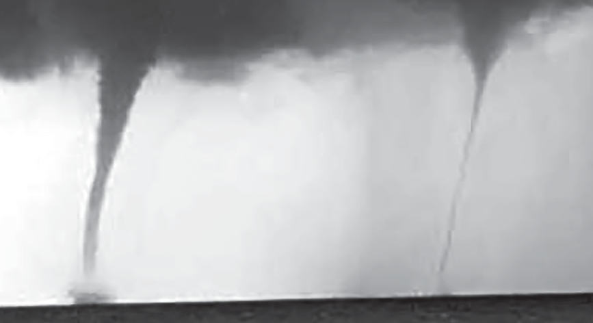
(Fig- waterspouts formation)
There are five stages of waterspout formation
Dark Spot: The initial stage of waterspout formation is marked by the appearance of a dark spot on the surface of the water where the vortex or column of rotating wind reaches it. This dark spot serves as the precursor to the development of the waterspout.
Spiral Pattern: Following the formation of the dark spot, light and dark bands begin to spiral outwards from the central point. This spiral pattern is indicative of the increasing organization and intensity of the rotating wind column.
Spray Ring: As the vortex gains strength, a swirling ring of sea spray, known as a cascade, forms around the dark spot. This cascade often exhibits an eye-like feature at its center, similar to the eye of a hurricane. The spray ring further emphasizes the rotational motion of the developing waterspout.
Mature Vortex: At this stage, the waterspout reaches its peak intensity and visibility. It extends from the surface of the water to the clouds overhead, exhibiting a hollow funnel shape surrounded by vapor. The mature vortex is the most intense and visually striking phase of waterspout formation.
Decay: Eventually, the flow of warm air into the vortex weakens, leading to the collapse of the waterspout. During the decay stage, the vortex dissipates and the waterspout ceases to exist. On average, waterspouts have a diameter of around 50 meters (165 feet) and wind speeds of approximately 80 kilometers per hour (50 miles per hour), similar to the weakest types of tornadoes on land.
In addition to posing risks to swimmers, boaters and coastal communities, waterspouts also present hazards to aircraft. Helicopters flying near waterspouts can experience damage and instability due to the intense winds associated with these phenomena.
Lightning and Thunder
LIGHTNING AND THUNDER
Lightning is a natural atmospheric electrical discharge that occurs either within a thunderstorm cloud (intra- cloud lightning) or between a thunderstorm cloud and the ground (cloud-to-ground lightning). It is caused by the buildup and discharge of electrical charges within the atmosphere, typically during thunderstorms.
Inside a thunderstorm cloud, various processes, such as collision and ice crystal formation, lead to the separation of positive and negative charges within different parts of the cloud. Typically, the upper part of the cloud becomes positively charged, while the lower part becomes negatively charged.
As the charge separation intensifies, it creates an electric field within the cloud. This electric field causes further
separation and polarization of charges, with positive charges congregating in one area and negative charges in another.
When the electric field strength reaches a critical threshold, it can overcome the insulating properties of the surrounding air, leading to the initiation of a lightning discharge. This discharge typically occurs between regions of opposite charge within the cloud or between the cloud and the ground.
During a lightning discharge, a channel of ionized air, known as a leader, forms and propagates either within the cloud or toward the ground. The leader is followed by a return stroke, during which a rapid flow of electrons travels back along the ionized path, producing the bright flash of light we observe as lightning.
The intense heat generated by the lightning discharge up to 30,000 C (54,000 F) causes the surrounding air to rapidly expand and cool. This rapid expansion creates a shock wave that propagates outward as a booming sound wave, known as thunder.
Types of Lightning: Lightning can take various forms, including intra-cloud lightning cloud-to-ground lightning, cloud-to-air lightning, and cloud-to-cloud lightning. Cloud-to-ground lightning is the most familiar type and is responsible for the majority of lightning- related damage and injuries.
Formation of Lightning Bolt
Within a thunderstorm cloud, processes such as collision and ice crystal formation lead to the separation of positive and negative charges. The upper part of the cloud becomes positively charged, while the lower part becomes negatively charged.
As the negative charge at the bottom of the cloud increases, a flow of negative charge called a stepped leader rushes toward the Earth. This stepped leader creates a path of ionized air as it moves downward.
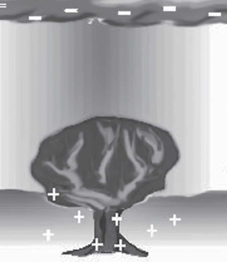
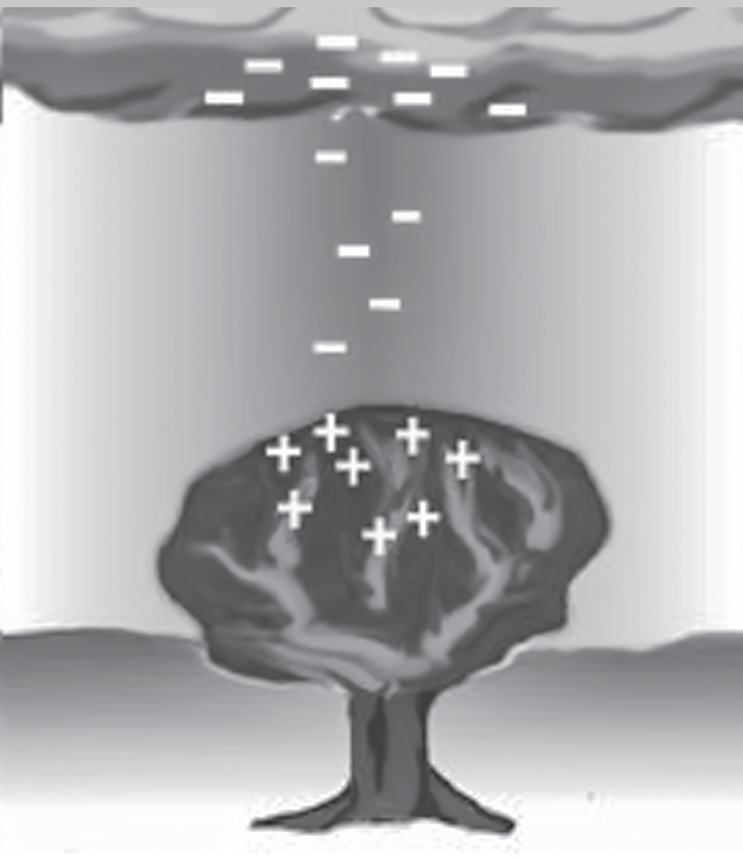
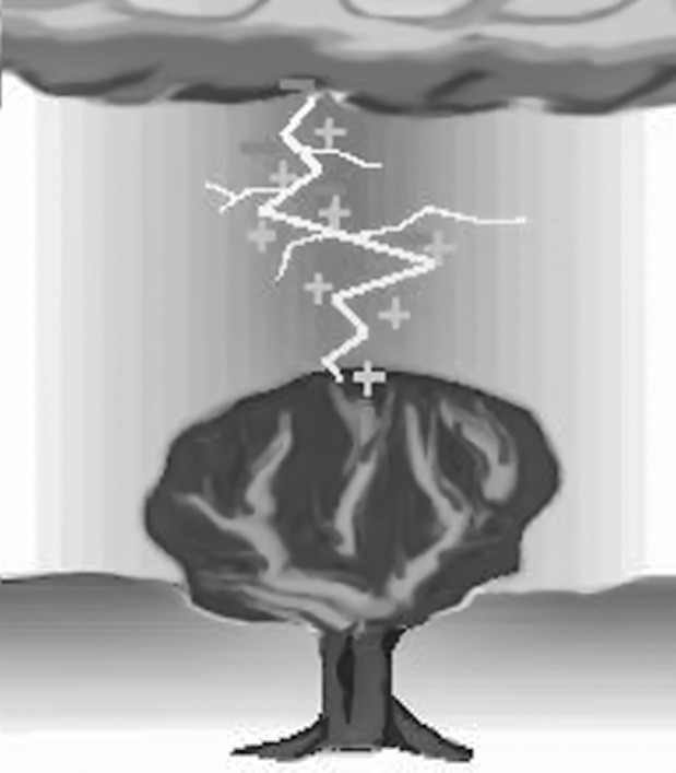
Positive charges at the ground are attracted to the stepped leader, causing positive charge to flow upward from the ground. These upward-moving positive charges create “positive streamers” that extend toward the approaching stepped leader.
When the stepped leader and the positive streamers meet, a strong electric current flows upward from the ground to the cloud. This upward flow of positive charge is known as the return stroke. The return stroke produces the bright flash of light we perceive as lightning.
The intense heat generated by the lightning bolt rapidly heats the surrounding air, causing it to expand explosively. This rapid expansion creates a shock wave that propagates outward as a booming sound wave, known as thunder.
Lightning and thunder occur nearly simultaneously, but because light travels much faster than sound, we see the flash of lightning before we hear the thunder. The delay between seeing the lightning and hearing the thunder can be used to estimate the distance to the lightning strike.
Where does Lightning Strike?
Lightning flashes during storms typically originate within
the cloud, and if the flash is going to strike the ground, a downward channel develops toward the surface. As this channel approaches the ground, tall objects such as trees, skyscrapers and mountains can initiate upward streamers, which are sparks that rise from their surfaces toward the descending channel.
When one of these upward streamers connects with the downward channel, a massive surge of electric current rapidly travels down the channel to the object that produced the spark. This phenomenon is what we observe as a lightning strike hitting the ground or a tall object.
Tall objects are more likely than the surrounding ground to produce these upward streamers because they can more easily generate the necessary electric potential gradient to do so. However, it’s important to note that not all tall objects will be struck by lightning, as the occurrence of upward streamers is influenced by various factors such as the conductivity of the object’s surface and the electric field in the vicinity.
Despite the higher likelihood of tall objects being struck, lightning can still hit the ground in open fields or other areas, even if the tree line or tall structures are nearby.
Hailstorm
HAILSTORM
A hailstorm is an unusual weather phenomenon in which balls of ice, called hail, fall from the sky. The ice balls are nothing more than solid precipitation that will form under certain conditions.
Conditions required for hailstorms to occur include
Presence of Cumulonimbus Clouds: Hailstorms typically occur within highly developed Cumulonimbus clouds, which are characterized by their towering, anvil or mushroom-like shapes. These clouds can reach impressive heights, sometimes exceeding 65,000 feet.
Strong Updrafts: Within these Cumulonimbus clouds, strong upward currents of air, known as updrafts, are necessary. These updrafts play a crucial role in lifting water droplets to higher altitudes where they freeze and form hailstones.
Ice Particles in Updrafts: The updrafts within the Cumulonimbus clouds contain ice particles. As the air rises, it cools, causing water droplets to freeze and become solid ice at high altitudes. These ice particles serve as the nuclei around which hailstones form.
Presence of Supercooled Liquid Water: The Cumulonimbus clouds must also contain high concentrations of supercooled liquid water. Supercooled water remains in liquid form despite being below the freezing point, providing the necessary material for hailstone growth.
Formation and fall of hail
Upward Movement: Hailstones are formed when raindrops are carried upward by strong thunderstorm updrafts into extremely cold regions of the atmosphere where temperatures are below freezing.
Freezing: As the raindrops rise, they encounter temperatures below freezing and freeze, forming tiny ice pellets.
Growth by Collision: These ice pellets, or hail embryos, then collide with supercooled liquid water droplets within the thunderstorm cloud. The liquid water freezes upon contact with the hail embryo, gradually building up its size.
Formation of Hailstone Layers: The rate at which the liquid water freezes onto the hail embryo determines the appearance of the hailstone. If the freezing is rapid, cloudy ice with trapped air bubbles forms. If freezing occurs slowly, the air bubbles escape, resulting in clear ice layers.
Fall: The hailstone continues to grow until it becomes too heavy for the thunderstorm updraft to support. At this point, the hailstone falls toward the ground under the force of gravity. The strength of the thunderstorm updraft determines how large the hailstone can grow before falling.
Horizontal Winds: Within a thunderstorm, horizontal winds also play a role. The updrafts may contain rotating winds, particularly in supercell thunderstorms, which can contribute to the formation and movement of hailstones. Additionally, horizontal winds in the surrounding environment can affect the trajectory of falling hailstones.
Altitude and Temperature: At high altitudes where temperatures are below -40 F, all liquid water freezes into ice. Hailstones require liquid water to grow significantly in size. Therefore, they fall when they become heavy enough to overcome the strength of the updraft and are pulled toward the Earth by gravity.