Waves and Tides
INTRODUCTION
The waters of oceans are never still. The oceans actually exhibit three major types of movements - waves, tides and currents.
WAVES
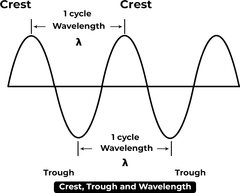
Waves are oscillatory movements that cause the rise and fall of the water surface. They consist of two main parts: the raised portion, known as the crest and the low areas between two crests called troughs.
Key terms related to waves include
Wave height: The vertical distance between a wave’s trough and crest.
Wave length: The horizontal distance between two crests or two troughs.
Wave period: The time it takes for two consecutive crests to pass a fixed point.
Waves with a short period move quickly, while those with a long period move more slowly.
TIDES
Tides, the movement of sea water upwards and downwards along coasts worldwide, exhibit fluctuations in sea level from hour to hour and day to day.
During a rising sea level, the incoming tide towards land is termed a flow tide or flood tide. On the other hand, when the sea level falls after a few hours, it’s referred to
as ebb tide or low tide. High tide occurs during flood tide, while low tide occurs during ebb tide.
The regular interval between two high tides or two low tides is approximately 12 hours and 25 minutes, not precisely 12 hours. Each day, high tide arrives about 51 minutes later than the previous day due to the rotational movement of the Earth. This delay also affects the rising and setting of the moon, which is approximately 51 minutes later each day.
Factors influencing tide regulation and size include
The alignment of the sun, moon and Earth, which rarely forms a straight line.
Variations in the distances between the sun, moon, and Earth.
The distribution of land and water on Earth’s surface.
The shape and configuration of coastlines, which can either amplify or impede tidal movements.
Tidal forces result from the gravitational attraction between celestial bodies such as the Earth, the moon and the sun. This gravitational force sets the ocean waters in motion, leading to the formation of tidal currents.
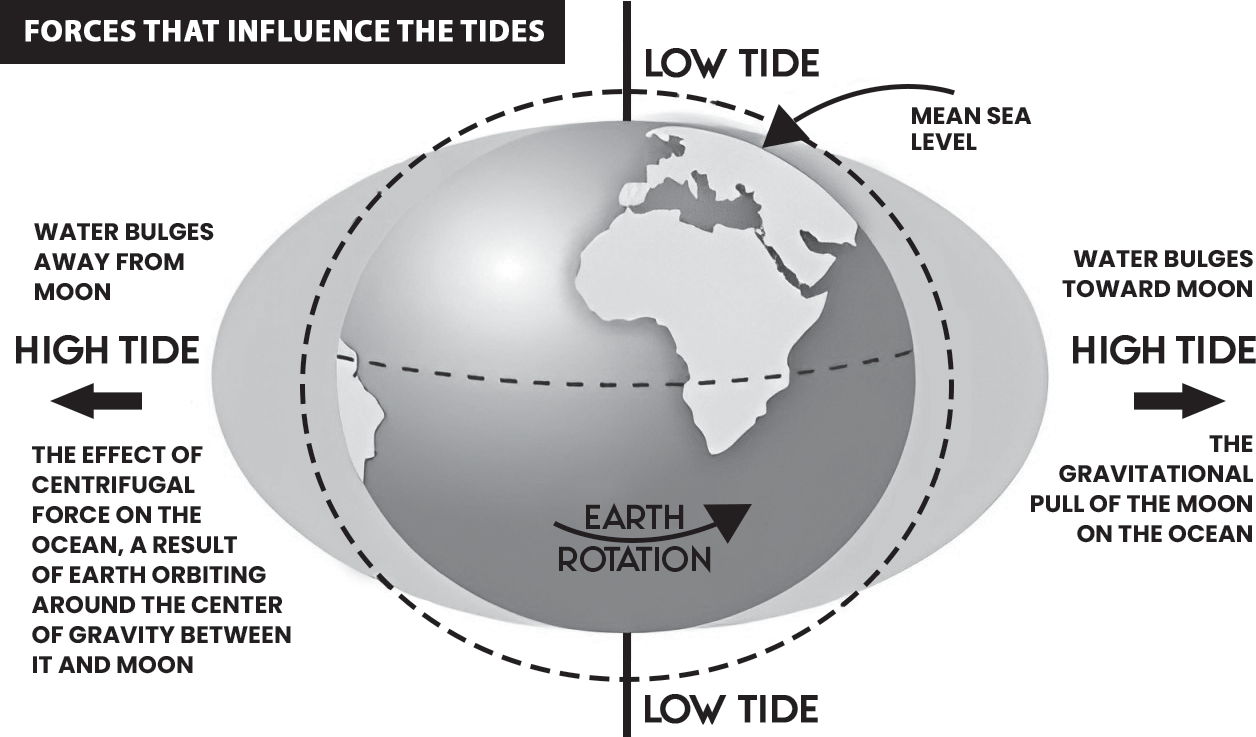
Both the moon and the sun exert gravitational forces on the Earth. Despite the sun’s greater mass, its greater distance from the Earth makes the moon’s gravitational attraction more effective. As a result, the moon’s gravitational pull causes noticeable bulging of water towards the side of the Earth facing the moon, as well as a smaller bulge on the opposite side.
The side of the Earth facing the moon experiences the strongest gravitational pull, causing water to be pulled towards the moon. On the other hand, the side farthest from the moon experiences the weakest gravitational pull. At the Earth’s center, the gravitational pull averages out.
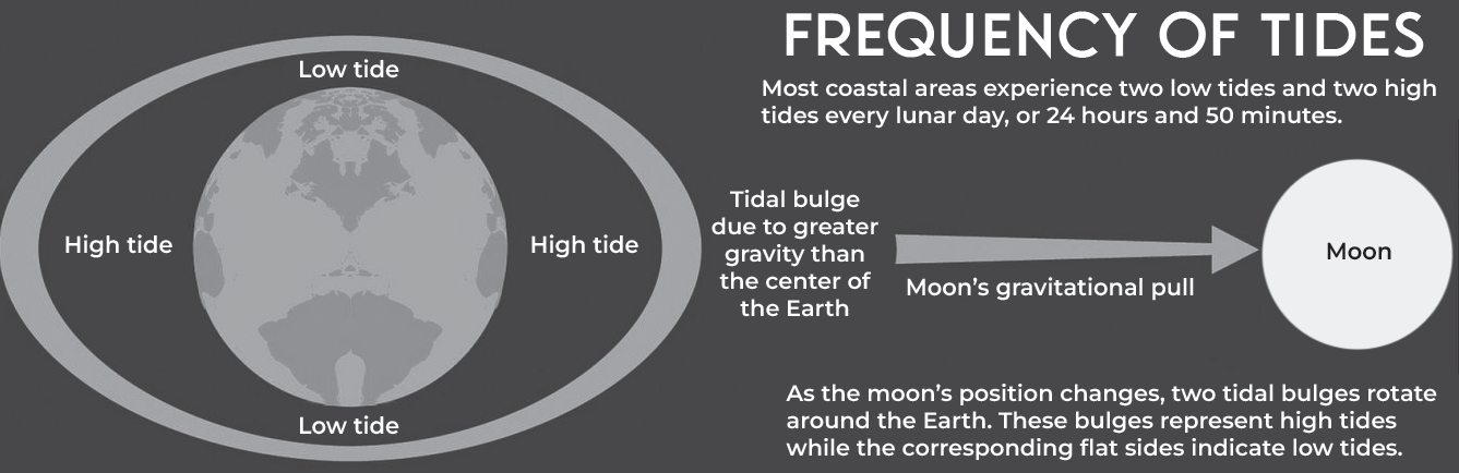
The tidal force results in a stretching and squashing of the Earth, leading to the formation of two tidal bulges—one facing the moon and one on the opposite side. As the Earth rotates through these bulges once a day, two high tides and two low tides occur, explaining the daily tidal cycle.
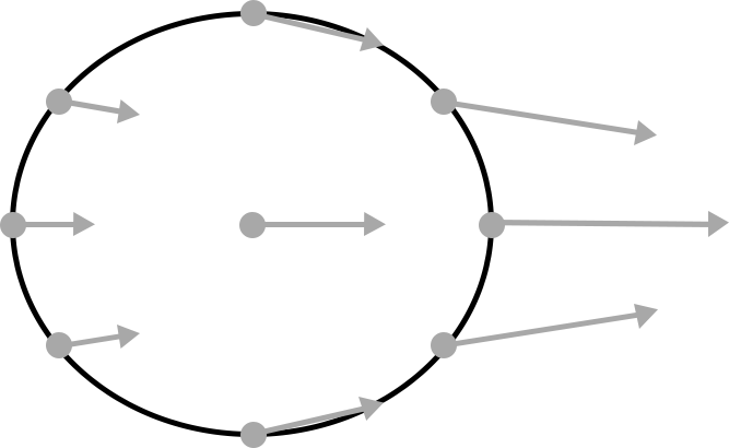
(Fig- Gravitational pull of moon)
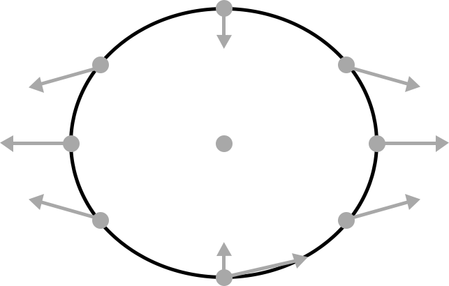
(Fig-Bulge in other sid e due to centrifugal force)
Classification of tides
There are two classifications for defining types of tides: based on the height of the tide and based on lunar phases.
Classification Based on the Height of the Tide
High Tide: Occurs when seawater reaches its greatest height within the tide cycle.
Low Tide: Occurs when seawater reaches its lowest height within the tide cycle.
Typically, there are two high tides and two low tides for every lunar day. This occurs because as the moon lifts the water over the Earth on the side facing it, it also separates the Earth from the water on the opposite side, resulting in water lifting over terrestrial surfaces on two diametrically opposite sides of the planet.
• Classification Based on Lunar Phase
Spring Tide
• It occurs during full or new moons when the Earth, sun, and moon are nearly in alignment.
• Average tidal ranges are slightly larger during spring tides, which happen twice each month.
• During a full moon, the Earth is between the moon and the sun, causing the gravitational pull of the sun to add to the gravitational pull of the moon on Earth. This results in higher high tides and lower low tides than usual, known as spring tides.
Neap Tide
It occurs during the moon’s first and third quarters when the gravitational forces of the sun and moon are at a right angle.
The gravitational pulls of the two bodies oppose each other and do not act in the same direction, neutralizing each other’s effects.
Neap tides produce weaker tides compared to spring tides.
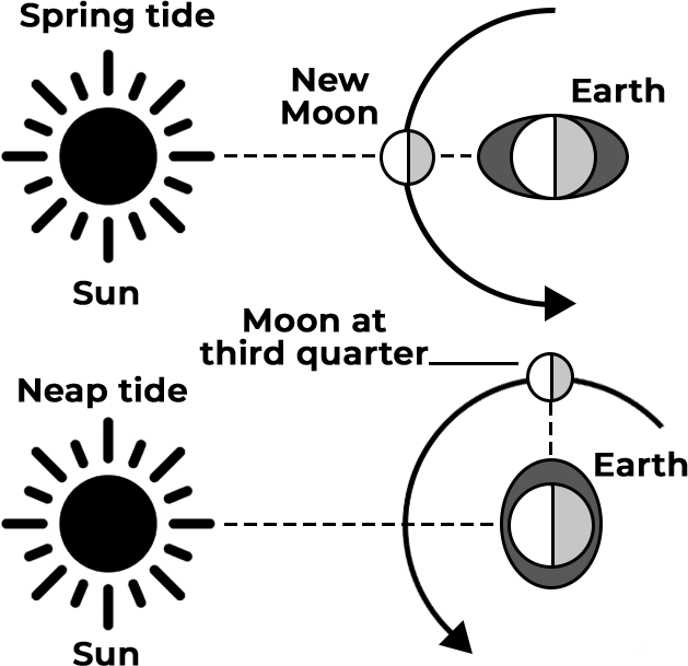
(Fig-Position o f Spring and Neap tide)
Importance of Tides
Fishing
Ebb tides, where water levels decrease, often lead to fish concentration. Commercial fishermen strategically utilize tidal patterns to fish during peak concentrations, optimizing their catch and economic returns.
Recreational fishermen also capitalize on ebb tides, as the smaller fish concentrated during this time attract larger trophy fish, enhancing the fishing experience.
Tidal currents play a crucial role in various aspects of oceanic life, including the reproductive activities of fish and ocean plants. These currents facilitate the movement of floating plants and animals between breeding areas and deeper waters, aiding in species dispersal and genetic diversity.
Furthermore, tidal currents help remove pollutants and circulate essential nutrients that ocean plants and animals require for survival. This circulation promotes a healthier marine ecosystem, supporting the abundance and diversity of marine life.
Tidal Zone Foods
Tidal zones host a variety of edible sea life, including crabs, mussels, snails, seaweed and other marine organisms.
These organisms thrive in the dynamic environment of the tidal zone, where they are exposed to both underwater and dry conditions during tidal cycles.
Small tide pools within the tidal zone may contain additional species of small fish and sea vegetables,
contributing to the biodiversity and abundance of food resources.
Communities often harvest these tidal zone foods for consumption, providing a vital source of nutrition and sustenance.
Tides play a crucial role in the maintenance of these food resources by regularly washing the tidal zone, replenishing nutrients and oxygen and removing waste. Without the regular action of tides, the delicate balance of the tidal ecosystem could be disrupted, leading to the decline of these food resources and potential food scarcity for both humans and marine life.
Navigation
Tides influence water depth and currents in coastal regions, which can impact ship navigation. Ships may need to navigate waters during high tide to avoid running aground in shallow areas. Pilots consider factors such as water level, channel width, and current direction to determine the optimal time for travel. Pilots may strategically choose to travel during ebb tides to accommodate tall loads, such as passing under bridges with limited clearance.
Tidal currents can either assist or hinder a ship’s progress in the water. Pilots leverage tidal flows to maneuver ships efficiently, taking advantage of currents to reach their destination.
A comprehensive understanding of how tides affect navigation and how to utilize them effectively enhances the productivity and safety of marine and inland shipping operations.
Weather
Tides and tidal currents play a significant role in influencing weather conditions by stirring ocean waters.
The mixing action of tides and tidal currents helps blend arctic water, which has a lower capacity to absorb sunlight, with warmer tropical water that can absorb sunlight more effectively.
This mixing process leads to the creation of more predictable and habitable climate conditions by balancing temperatures across different regions of the planet.
By redistributing heat and nutrients through the oceans, tides and tidal currents contribute to maintaining a stable and conducive environment for various forms of life.
Tidal Energy
Tides follow a predictable pattern, with two high tides and two low tides occurring approximately every 24 hours.
The consistent and predictable nature of tides, along with the rapid movement of water during inflow and outflow, presents an opportunity for harnessing tidal energy.
Coastal communities can utilize tidal energy as a renewable energy source by deploying hydroelectric plants that exploit the movement of water, similar to how rivers are utilized for hydroelectric power generation.
Tidal energy offers significant potential for meeting energy needs sustainably, particularly in coastal regions where tidal movements are prominent. As a renewable energy source, tidal energy aligns with global efforts to reduce reliance on fossil fuels and mitigate climate change. Tapping into tidal energy resources can contribute to achieving ambitious renewable energy targets, such as India’s goal of reaching 500 gigawatts of renewable energy capacity.
Tidal Power Development in India
The Standing Committee on Energy, chaired by Mr. Rajiv Ranjan Singh, released a report on “Tidal Power Development in India” in August 2021. Tidal energy, derived from the movement of ocean tides, was the subject of focus. Here are the key observations and recommendations outlined in the report:
The Committee identified three main types of ocean energy: wave energy, tidal energy, and ocean-thermal energy. These forms of energy utilize different mechanisms to harness energy from the ocean, such as the movement of waves, tidal currents, and temperature differentials in ocean waters. Theoretical estimates suggest significant potential for tidal and wave energy in India. The theoretical potential for tidal energy is estimated at 12.5 gigawatts, while wave energy is estimated at 41.3 gigawatts. However, the potential for ocean-thermal energy has not been estimated thus far. The Committee noted that theoretical potential does not necessarily translate into practically exploitable potential. In light of the above, the Committee recommended that the central government should reassess the exploitable potential of tidal, wave, and ocean energy.
Cost of Tidal Power Plants: The committee noted the closure of two tidal power plants in the past due to high costs.
Highlighted the costs per megawatt (MW) of these plants: Rs 63.5 crore per MW for the 3.75 MW plant in West Bengal and Rs 15 crore per MW for the 50 MW plant in Gujarat.
Recommended reassessment of the current cost of tidal power to determine economic viability and long-term benefits.
Setting up Pilot Tidal Power Project: Tidal energy was not included in India’s 2022 renewable energy target, but all renewable sources will be eligible for the 2030 target.
The committee recommended setting up a pilot tidal power project, preferably in a cost-effective location such as the Gulf of Kutch.
Environmental Impact Assessment: The committee observed the lack of studies assessing the environmental and ecological impact of tidal power plants.
Noted potential environmental impacts upstream and downstream.
Recommended conducting an assessment of the environmental impact and ecological sustainability of tidal power plants.
Research and Development
The committee noted insufficient funds allocated by the central government for tidal power development.
Observed significant reductions in funds allocated to the Ministry of New and Renewable Energy for research and development.
Recommended against reducing funds for research and advocated for significant support for un-harnessed sources like tidal energy.
Tidal Bores
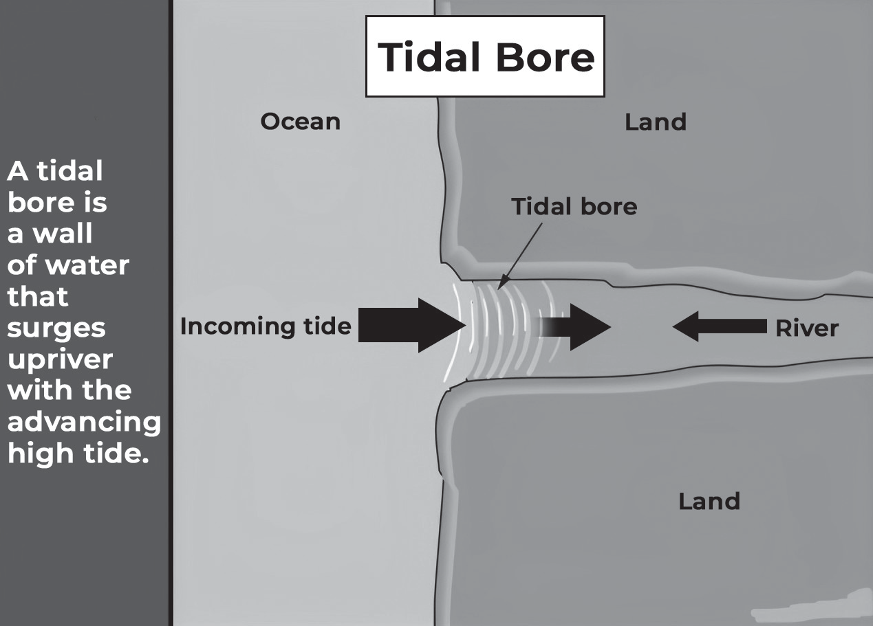
A tidal bore refers to a wave or a series of waves that propagate upstream as the tidal flow shifts to rising. Typically occurring in areas with large tidal ranges, usually more than 6 to 9 meters, tidal bores manifest in flat, converging channels, often taking on a funnel-like shape. The surge at the front of the bore absorbs random disturbances from both sides, contributing to the wave’s stability and self-perpetuation.
Several well-known examples of tidal bores include the Hangzhou (or Hangchow) bore on the Qiantang River in China, the Amazon bore known as Pororoca in Brazil, the tidal bore on the Seine River (Mascaret) in France and the Hoogly (or Hooghly) bore on the Ganges in India. Additionally, numerous tidal bores occur in tropical regions worldwide.
The formation of tidal bores is primarily influenced by the progressive distortion of the tidal wave as it travels up the estuary. As the tidal wave encounters varying topography and channel configurations, it undergoes distortion, leading to the formation of the characteristic bore.
Impact of tidal bore
Ecological Impact
Tidal bores directly affect the ecology of river mouths, potentially causing harm to animals caught in the leading edge of the tidal wave.
Animals may become dazed or even perish in the turbulent waters, attracting carnivores and scavengers.
Studies conducted at rivers like Petitcodiac and Shubenacadie in Canada have examined the effects of tidal bores on sediment transport.
Physical Impact
Tidal bores can exhibit violent behavior, leading to changes in the color of the river as sediment is churned up, turning the water brown.
Vegetation along riverbanks, including trees, can be uprooted and damaged by the force of the bore, posing risks to recreational activities such as river surfing and kayaking.
Recreational Opportunities
While tidal bores can be dangerous, they also offer opportunities for recreation, such as river surfing and kayaking, for those who understand the phenomenon and take appropriate precautions.
The Severn River in the United Kingdom is famous for its tidal bore events, attracting hundreds of surfers and thousands of spectators when large bores are predicted.
Human Activity and Management
Human activity, such as river management practices like canals, dams and dredging, can alter or even eliminate tidal bores.
The example of the Seine River in France shows how years of river management efforts have removed a once-strong tidal bore, known as the Mascaret, which was responsible for disrupting shipping and causing damage to ships and docks.
Ocean Current
OCEAN CURRENT
Oceanic currents refer to the continuous and predictable movement of seawater in oceans and seas. These movements are primarily driven by a combination of factors such as gravity, wind patterns (including the Coriolis Effect), and differences in water density. This abiotic system plays a crucial role in various Earth processes, including the transfer of heat, the distribution of nutrients, and influencing climate patterns.
There are two main types of movements associated with ocean currents: horizontal and vertical. Horizontal movements, known as currents, describe the lateral flow of water across the ocean surface.
Vertical movements, on the other hand, involve the upward or downward flow of water within the ocean. Upwellings refer to the upward movement of nutrient-rich cold water from the ocean depths towards the surface. These regions are often associated with increased biological productivity due to the availability of nutrients. On the other hand, downwellings occur when surface water sinks towards deeper layers of the ocean, which can impact nutrient distribution and ocean circulation patterns.
Oceanic currents play a significant role in shaping the Earth’s climate system by transporting heat around the globe. For example, the Gulf Stream in the North Atlantic Ocean carries warm water from the tropics towards higher
latitudes, influencing the climate of regions it passes through. Similarly, the Antarctic Circumpolar Current helps regulate global climate by facilitating the exchange of heat between the Southern Ocean and other ocean basins.
Currents are typically measured in terms of their speed, which can be expressed in meters per second or knots. One knot is equivalent to approximately 1.85 kilometers per hour or 1.15 miles per hour.
Ocean currents are influenced by two different forces. They are:
• Primary forces
• Secondary forces
Wind: Surface winds blowing across the ocean’s surface exert frictional forces on the water, transferring some of their momentum to the ocean. This interaction between wind and water generates surface currents, which can travel significant distances across the ocean basins. The direction and strength of these currents are influenced by factors such as the speed and direction of the wind, the Earth’s rotation, and the geography of the ocean basin.
Secondary Forces
• Temperature differentials: Variations in water temperature contribute significantly to the formation and direction of ocean currents. Cold water is denser than warm water, so it tends to sink while warmer water rises. This movement sets up a circulation pattern known as thermohaline circulation, where cold, dense water sinks at high latitudes and goes towards the equator, while warmer water moves poleward to replace it. These temperature-driven currents play a crucial role in redistributing heat around the globe and shaping regional climate patterns.
• Variations in water density: Differences in water density, often driven by differences in salinity and temperature, also influence the behavior of ocean currents. Salinity affects water density, with higher salinity leading to increased density. Regions with higher salinity, such as near the equator where evaporation rates are high, may experience denser water that sinks and forms deep currents. On the other hand, areas with lower salinity, such as near river mouths or in regions of heavy precipitation, may have less dense surface waters that flow along the ocean’s surface.
• Underwater Earthquakes: While not as prevalent as other factors, underwater earthquakes can indeed influence ocean currents, particularly in localized areas. These seismic events can displace large volumes of water, leading to the generation of tsunamis or other wave disturbances that can propagate across the ocean. Additionally, underwater earthquakes can trigger turbidity currents, which are rapid flows of sediment- laden water moving downslope along the ocean floor. While the effects of underwater earthquakes on ocean currents are typically short-lived and localized, they can still have significant impacts on marine ecosystems and coastal communities in affected regions.
Ocean Currents & Water Mass
| Feature | Ocean Currents | Water Masses |
| Scale | Ocean currents are large-scale movements of water in the ocean. | Regional or sub-regional |
| Movement | They transport heat, nutrients, and plankton around the globe | Relatively static or slow-moving |
| Driving forces | Wind patterns, density differences | Temperature, salinity, density |
| Impacts | Transport heat, nutrients, and plankton; distribute marine organisms; shape coastal ecosystems. They lead to desert formation as cold currents inhibit rains. Upwelling of water brings nutrients to surface for a productive ecosystem. | Define habitats for marine organisms; influence productivity and biodiversity; affect coastal temperatures and weathe |
| Example | The Gulf Stream carries warm, nutrient-rich waters from the Gulf of Mexico to the North Atlantic, supporting abundant marine life, including fish, whales, and plankton. The Kuroshio Current transports warm water from the Pacific Ocean to the coast of Japan, contributing to the region’s rich fisheries and temperate climate. The Humboldt Current brings cold, nutrient-upwelling waters from the Antarctic to the coast of South America, creating a unique ecosystem with abundant marine life, including penguins, seals, and sea lions. | North Atlantic Deep Water is a cold, dense water mass forms in the North Atlantic Ocean and sinks to the bottom of the ocean, influencing global ocean circulation and deep-sea ecosystems. Mediterranean Sea Water is a warm, salty water mass forms in the Mediterranean Sea and exits through the Strait of Gibraltar, influencing the salinity and temperature of the Atlantic Ocean. |
Types of Ocean currents
Classification based on the temperature of ocean currents
• Cold ocean currents: Cold ocean currents transport cold water from higher latitudes towards lower latitudes or warmer regions. These currents are typically found on the eastern coastlines of continents in higher latitudes in the Northern Hemisphere.
• Warm water currents: Warm water currents transport warm water from lower latitudes towards higher latitudes or colder regions. These currents are typically found on the eastern coastlines of continents in lower to middle latitudes.
Classification based on the depth of water
• Deep ocean currents: These currents occur in the deeper layers of the ocean and are driven primarily by differences in water density, influenced by factors such as temperature and salinity. Cold, dense water sinks into the ocean basins at higher latitudes where temperatures are sufficiently cold to increase density. These currents are often part of the thermohaline circulation system and play a crucial role in global heat transport and nutrient distribution. Deep ocean currents are slower and more sluggish compared to surface currents due to the denser water and the absence of direct wind influence.
• Surface ocean currents: Surface currents occur in the upper layer of the ocean and are primarily driven
by primary forces such as wind and solar energy. Wind patterns, influenced by the Earth’s rotation and atmospheric pressure systems, create frictional forces on the ocean surface, leading to the formation of surface currents. Solar energy heats the ocean surface, creating temperature gradients that further influence the movement of surface currents. These currents play a significant role in redistributing heat from tropical regions to higher latitudes, affecting regional and global weather patterns. Surface currents are generally faster and more visible compared to deep ocean currents, and they have a more direct impact on marine navigation, coastal ecosystems, and climate.
Effects of Ocean Currents
Contribution to Rainfall: Warm Ocean currents facilitate evaporation, which contributes to the moisture content in the air. This moisture can lead to increased rainfall in coastal regions influenced by these currents. For example, the North Atlantic Drift brings moisture to Western Europe, contributing to rainfall throughout the year.
Desert Formation: Cold ocean currents, by contrast, typically do not generate moisture-laden winds, resulting in lower precipitation levels in coastal areas. This can lead to desertification in regions affected by these currents. Examples include the Kalahari Desert influenced by the cold Benguela Current and the Patagonia Desert affected by the Falkland Current.
• Impact on Marine Life: Strong Ocean currents can have detrimental effects on marine wildlife. For instance, powerful currents may destroy plankton populations, disrupting the marine food chain. An example is the El Niño current, which can devastate plankton along the Peruvian coast and contribute to the spread of diseases that affect fish populations.
• Nutrient Cycling and Ecosystem Support: Certain ocean currents, particularly upwelling currents, play a vital role in nutrient cycling and supporting marine ecosystems. For instance, upwelling currents in Antarctica bring nutrients from the deep sea to the surface, fueling the growth of algae and plankton. These organisms form the basis of the food chain, sustaining populations of krill, which in turn support various marine predators like penguins, seabirds, seals and whales.
• Navigation and Transportation Benefits: Knowledge of ocean currents can be advantageous for sailors and shipping companies. When currents align with their routes, ships can benefit from faster travel times and reduced fuel consumption. However, currents opposing their direction can increase travel time and fuel costs, requiring ships to navigate more challenging conditions.
• Hazards and Risks: Strong Ocean currents, particularly when combined with other factors like storms or geological events, can pose hazards to maritime activities. Ships may encounter difficulties navigating through strong currents, leading to accidents, property damage and potential loss of life. While such incidents are relatively rare, they highlight the importance of understanding and respecting the power of ocean currents.
Importance of Ocean Currents
• Controlling the climate: Ocean currents play a crucial role in regulating global climate by redistributing heat from the equator to the poles. This helps maintain the Earth’s natural climate balance and temperature gradients.
• Critical to marine life: Ocean currents are essential for marine ecosystems as they transport nutrients, food organisms, and reproductive cells, supporting the diverse array of life in the ocean. Marine wildlife relies on ocean currents for food sources, habitat distribution, and reproductive cycles. The best example is sea turtles that lay eggs in the sand along the shores of the ocean. The ocean currents then carry the young hatchlings into the water.
• Vital for polar ports: Warm Ocean currents help keep ports in polar regions ice-free, facilitating maritime trade and transportation. Ports in regions like Europe benefit from warm currents such as the North Atlantic Drift, which prevent ice formation and ensure year-round operability.
Dispersal of life forms: Ocean currents play a key role in dispersing various life forms, aiding in the distribution of species and influencing their life cycles. For example, the migration patterns of species like the European eel are heavily influenced by ocean currents.
Transportation by humans: Humans utilize ocean currents for transportation purposes, including navigation, shipping and search and rescue operations. Currents help propel vessels, optimize shipping routes, and assist in maneuvering through narrow waterways, enhancing efficiency and safety at sea.
Recreational activities: Ocean currents contribute to the formation of waves that are utilized for recreational activities such as surfing. Surfers harness the energy of waves generated by currents, engaging in competitive sports and leisure pursuits along coastlines worldwide.
How Do Ocean Currents Affect the Climate?
Regulation of polar climates: Warm Ocean currents transport heat from equatorial regions towards the poles, helping to moderate the climate around polar regions.
Influence on precipitation patterns: Ocean currents play a role in determining precipitation patterns by affecting evaporation rates and atmospheric moisture content. Warm currents can increase evaporation rates, leading to the formation of clouds and rainfall along coastal regions or over adjacent landmasses.
Oceanic factors driving currents: Various factors within the ocean, such as water density, temperature gradients, and salinity variations, influence the direction and intensity of ocean currents. These factors interact to create complex circulation patterns that can affect regional and global climates.
Formation of global conveyor belts: Ocean currents form interconnected circulation patterns known as global conveyor belts, which play a crucial role in redistributing heat and regulating climate on a global scale. For example, the thermohaline circulation system involves the sinking of dense, cold water in polar regions and the upwelling of warmer water in equatorial regions. This circulation pattern helps transport heat around the globe and influences climate patterns in regions affected by these currents.
Regional climate impacts: Specific Ocean currents can have pronounced effects on regional climates. For instance, the North Atlantic Drift brings moisture and warmth to western Europe, contributing to the relatively mild and wet climate in countries like the United Kingdom. On the other hand, cold currents such as the Benguela Current off the coast of southwestern Africa and the Falkland Current near South America can create arid conditions, leading to the formation of deserts like the Kalahari and Patagonia Deserts, respectively.
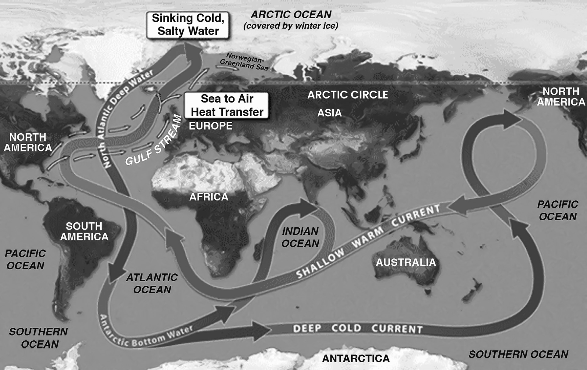
Thermohalin e Circulations
Current of Pacific Ocean
There are ten main currents in the Pacific Ocean
North Equatorial Current (Warm)
• The North Equatorial Current is a warm ocean current that originates off the western coast of Mexico. It flows in a westerly direction and extends for approximately 7500 nautical miles until it reaches the Philippines coast.
• This current is primarily formed due to the convergence of two main factors: the Californian Current and the northeast monsoon. The Californian Current, which flows southward along the western coast of North America, contributes to the initial formation of the North Equatorial Current. Additionally, the northeast monsoon, a seasonal wind pattern that blows from northeast to southwest over the Pacific Ocean, further influences the direction and strength of the current.
• As the North Equatorial Current progresses westward, its volume of water continuously increases due to the contribution of numerous minor branches joining from the north. These minor branches may originate from various sources, including adjacent ocean currents or localized wind-driven currents. The combined flow of water from these sources contributes to the overall strength and persistence of the North Equatorial Current as it travels across the Pacific Ocean.
South Equatorial Current (Warm)
• The South Equatorial Current is formed primarily due to the influence of the southeast trade winds and flows from
east to west across the equatorial region of the ocean.
This current tends to be stronger than its northern counterpart, the North Equatorial Current. As the South Equatorial Current progresses from east to west, it gathers momentum and volume as numerous minor currents merge into it from the left (or northern) side. These minor currents may originate from various sources, including adjacent ocean currents or local wind-driven currents. The accumulation of water from these sources contributes to the overall strength and persistence of the South Equatorial Current as it moves across the ocean.
Near New Guinea, the South Equatorial Current bifurcates into northern and southern branches. The northern branch turns eastward and flows as the Counter Equatorial Current, while the southern branch moves towards the northern and northeastern coasts of Australia. This bifurcation and redirection of the current contribute to the complex circulation patterns in the equatorial region of the ocean.
Counter Equatorial Current (Warm)
The Counter Equatorial Current is a warm ocean current that flows from west to east between the North and South Equatorial Currents.
The formation of this current is primarily driven by the influence of the trade winds. These trade winds cause an immense volume of water to accumulate in the western marginal parts of the ocean basin. As a result, there is a general slope gradient of the water surface from west to east, with higher water levels in the west.
• Due to this descending slope gradient of the water surface from west to east, oceanic water flows in an easterly direction, giving rise to the Counter Equatorial Current. This current is the most developed counter current in the Pacific Ocean and serves as a significant component of the complex circulation patterns within the equatorial region.
Kuroshio System (Warm)
The Kuroshio System is a warm ocean current system in the Pacific Ocean, similar to the Gulf Stream system in the Atlantic Ocean. It consists of several currents and drifts extending from Taiwan to the Bering Strait:
Kuroshio Current: Originating from the North Equatorial Current, the Kuroshio Current forms when the north equatorial current is obstructed by the Philippines, causing it to turn northward. The Kuroshio flows from Taiwan to the Ryukyu ridge at approximately 30 N latitude. It is a warm current comparable to the Florida Current in the North Atlantic Ocean.
Kuroshio Extension: After leaving the Japanese coast, the Kuroshio Current turns eastward near 35 N latitude under the influence of the westerlies. It bifurcates into two branches, with one branch moving eastward and the other flowing northeastward before turning eastward again. The northern branch eventually merges with the cold Oyashio Current from the north.
North Pacific Drift: The Kuroshio Current extends further eastward under the influence of the westerlies, reaching the western coast of North America. Near 150 W longitude, the major part of this current turns southward, while some water continues eastward towards the Hawaiian coast and the western coast of North America. The North Pacific Drift bifurcates into two branches: the Aleutian Current to the north and the Californian Cold Current to the south. The Aleutian Current further divides into branches heading towards the Bering Strait and the Gulf of Alaska.
Tsushima Current: Near 30 N latitude, a branch separates from the Kuroshio Current and enters the Japan Sea as the Tsushima Current. This warm current, characterized by relatively higher temperature and salinity, influences the weather conditions along the western coast of Japan.
Counter Kuroshio Current: The Kuroshio Current forms a gyral system between the Hawaiian Islands and the American coast, resulting in the oceanic water moving in a westerly direction known as the Counter Kuroshio Current.
Oyashio Current (Cold)
• The Oyashio cold current is also known as Kurile or Oya Siwo cold current.
• This cold current flows through the Bering Strait in southerly direction and thus transports cold water of the Arctic Sea into the Pacific Ocean.
California Current (Cold)
The California Current is an example of a cold ocean current, representing the eastward extension of the North Pacific Drift.
It is generated by the movement of oceanic water along the coast of California from north to south.
The cold California Current forms as a result of the need to compensate for the loss of water caused by the large- scale transport of water off the coast of Mexico under the influence of trade winds, particularly the North Equatorial Current.
After reaching the Mexican coast, the California Current turns westward and eventually merges with the North Equatorial Current.
Peru Current (Humboldt Current) (Cold)
The Peru Current, or Humboldt Current, is a cold ocean current that flows along the western coast of South America from south to north.
Near the coast, it is known as the Peru Coastal Current, while further offshore, it is referred to as the Peru Oceanic Current.
The Peru Current is a critical component of the climate system along the western coast of South America, influencing weather patterns, marine life, and oceanographic processes in the region.
El Niño (Counter Current) (Warm)
El Niño, or the Counter Current, is a subsurface warm current that flows from north to south between latitudes 3 S and 36 S, located approximately 180 km off the Peruvian coast.
The southward shift of the counter-equatorial warm current during the southern winter gives rise to the El Niño current.
El Niño events can lead to significant disruptions in weather patterns, including increased rainfall along coastal areas, fish die-offs due to changes in plankton populations, and the occurrence of diseases and pests such as guano disease.
El Niño can also impact monsoon patterns in the Indian Ocean, influencing weather conditions in distant regions.
East Australia Current (Warm)
The East Australia Current is formed when the South Equatorial Current bifurcates near the Australian coast into northern and southern branches.
The southern branch flows as the East Australia Current from north to south along the eastern coasts of Australia.
New Zealand is surrounded by this current, which is deflected eastward near 40 S latitude due to the deflective force of the Earth and flows in an easterly direction under the influence of the westerlies.
• This warm and consistent current raises the temperature of the eastern Australian coast for a considerable distance southward, influencing local climates and marine ecosystems.
West Wind Drift (Cold)
• The West Wind Drift is a strong ocean current that flows from west to east under the influence of the westerlies, which are prevailing winds that blow from west to east in the Southern Hemisphere.
• This current is situated between Tasmania and the South American coast within the zone of 40 -50 S latitudes.
The West Wind Drift gains strength due to the immense volume of water mass and high-velocity winds known as the roaring forties, which are strong westerly winds found in the Southern Hemisphere between 40 and 50 latitude. The current flows with great velocity as a result of these factors.
In the Far East, the West Wind Drift bifurcates into two branches. One branch enters the Atlantic Ocean through Cape Horn, the southernmost tip of South America, while the second branch turns northward and joins the Peru Current, a cold ocean current flowing along the western coast of South America.
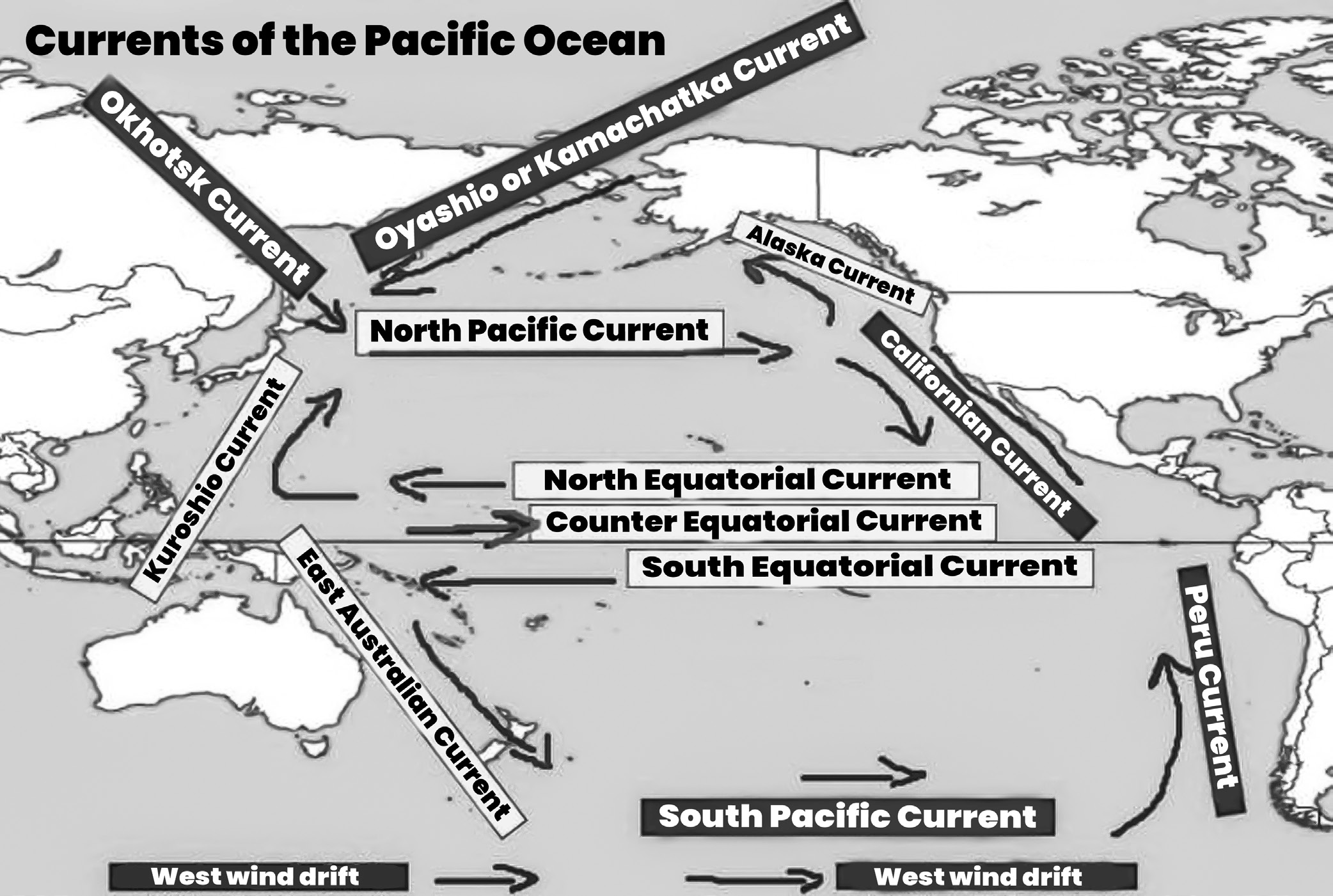
(Fig- Currents of Pacific Ocean)
Current of Atlantic Ocean
The trade winds establish a system of equatorial currents that can extend over large distances, sometimes spanning up to 50 of latitude or more. Within this system, there are two main westerly-flowing currents that generally correspond to the areas influenced by the trade winds. These currents are separated by a weaker, easterly-flowing countercurrent.
• North Equatorial Current: This current originates to the north of the Cape Verde Islands and flows almost directly westward.
• South Equatorial Current: The South Equatorial Current is more extensive compared to its northern counterpart. It
originates off the west coast of Africa, typically south of the Gulf of Guinea, and flows generally in a westerly direction across the equatorial region of the Atlantic Ocean.
The major currents of Atlantic Ocean are as Follows:
North Equatorial Current (Warm)
The North Equatorial Current flows from east to west
between approximately 10 north and 20 north latitude.
This current is generated in part due to the upwelling of cold water near the west coast of Africa. The upwelling process brings nutrient-rich cold water to the surface, which then contributes to the formation of the North Equatorial Current.
• The North Equatorial Current is further pushed westward by the cold Canary Current. Despite being a warm current, it is influenced by the presence of the colder Canary Current.
• As the North Equatorial Current crosses the mid-Atlantic Ridge near 15 N latitude, it is deflected northward. This deflection occurs due to the underwater topography of the ridge.
• After crossing the ridge, the current turns southward again. Upon encountering the land barrier of the east coast of Brazil, the North Equatorial Current bifurcates into two branches:
• This branch is diverted northward and flows to the east of the West Indies islands. It contributes to the formation of the Sargasso Sea eddy, a large whirlpool-like gyre in the North Atlantic Ocean.
• The second branch, known as the Caribbean Current, enters the Gulf of Mexico and eventually becomes part of the Gulf Stream, a powerful warm ocean current that flows along the eastern coast of North America.
South Equatorial Current (warm)
• The South Equatorial Current is a significant ocean current found in the Pacific, Atlantic, and Indian Oceans.
• The South Equatorial Current flows from east to west between the equator and approximately 20 degrees south latitude. In the Pacific and Atlantic Oceans, it extends across the equator to about 5 degrees north latitude.
• This current stretches from the western coast of Africa to the eastern coast of South America, spanning between the equator and 20 S latitude.
• The South Equatorial Current is characterized by being more constant, stronger, and of greater extent compared to the North Equatorial Current.
• It is considered the continuation of the cold Benguela Current, which originates off the coast of southwestern Africa.
• The South Equatorial Current is bifurcated into two branches when it encounters the land barrier formed by the east coast of Brazil. One branch takes a northwesterly course and merges with the North Equatorial Current near Trinidad. The second branch turns southward and continues as the Brazil Warm Current, flowing parallel to the east coast of South America.
• The South Equatorial Current is primarily driven by the stress of the trade winds, which blow from east to west across the equatorial regions of the ocean.
Equatorial Counter Current (Warm):
• The Equatorial Counter Current flows from west to east, moving in the opposite direction to the strong westward- flowing North and South Equatorial Currents.
This current is less developed in the western part of its path due to the influence of the trade winds. In the west, it tends to mix with the Equatorial Currents. However, it becomes more pronounced and defined in the eastern part of its path. In this region, it is known as the Guinea Stream.
The Equatorial Counter Current carries relatively higher temperatures and lower densities compared to the two equatorial currents.
Gulf Stream (Warm)
The Gulf Stream consists of several currents moving in a northeasterly direction. It is considered the fastest ocean current in the world.
The Gulf Stream system originates in the Gulf of Mexico around 20 N latitude and flows in a northeasterly direction along the eastern coast of North America. It extends towards the western coasts of Europe, reaching as far north as approximately 70 N latitude.
This current flows from the Strait of Florida to Cape Hatteras. It is essentially the northward extension of the North Equatorial Current. The Florida Current passes through the Yucatan Channel into the Gulf of Mexico and then proceeds through the Florida Strait, reaching approximately 30 N latitude.
After receiving water from the Antilles Current, the Florida Current becomes known as the Gulf Stream. The Gulf Stream carries warm water northward into colder latitudes, modifying weather conditions in adjacent areas. It generally follows the coastline but is deflected eastward at approximately 40 N latitude due to the influence of the westerlies and the Coriolis force.
The Gulf Stream is divided into multiple branches around 45 N and 45 W longitude. These branches collectively form the North Atlantic Drift or current. The main current continues as the North Atlantic Drift, reaching the British Isles and then flowing along the coast of Norway as the Norwegian Current, eventually entering the Arctic Ocean. Another branch flows between Spain and the Azores as the cold Canary Current, which eventually
joins the North Equatorial Current, completing the circuit in the North Atlantic.
• The Gulf Stream system encompasses the Sargasso Sea, which is rich in seaweed. This area is located within the circuit formed by the North Atlantic Drift and serves as a habitat for various marine species.
Canaries Current (Cold)
• The Canaries Current is a cold ocean current that flows southwards along the coasts of Europe and Africa. It eventually merges with the North Equatorial Current.
• Originating from the polar regions, this current carries cold water towards the warm waters of lower latitudes.
• The Canaries Cold Current helps moderate the otherwise hot weather conditions along the western coasts of North Africa.
Labrador Current (Cold)
• The Labrador Current is a cold ocean current that flows along the eastern coast of Canada, southeastwards between West Greenland and Baffin Island of Canada.
• This current meets the warm Gulf Stream off Newfoundland, Canada.
• The convergence of these two currents at Newfoundland, particularly around the Grand Bank region, results in the formation of fog and creates one of the most important fishing grounds in the world.
Brazil Current (Warm)
• The Brazil Current is a warm ocean current generated by the bifurcation of the South Equatorial Current when it encounters the obstruction of the Brazilian coast near Sun Rock.
• The northern branch of this bifurcation flows northward and merges with the North Equatorial Current.
The southern branch, known as the Brazil Current, flows southward along the east coast of South America, reaching approximately 40 S latitude.
Falkland Current (Cold)
The Falkland Current is a cold ocean current that flows from south to north along the eastern coast of South America, extending up to Argentina.
It originates from the cold waters of the Antarctic Sea and becomes most extensive and developed near 30 S latitude.
This current is responsible for carrying numerous icebergs from the Antarctic area to the South American coast.
South Atlantic Drift (Cold)
The South Atlantic Drift, also known as the Westerlies Drift or Antarctic Drift, is the eastward continuation of the Brazil Current.
It is generated by the eastward deflection of the Brazil Warm Current due to the Earth’s rotation.
The South Atlantic Drift flows eastward under the influence of the westerlies, which are prevailing winds in the region.
Benguela Current (Cold)
The Benguela Current is a cold ocean current that flows from south to north along the western coast of South Africa.
It is formed as a result of the South Atlantic Drift turning northward due to obstruction caused by the southern tip of Africa.
Further northward, the Benguela Current merges with the South Equatorial Current.
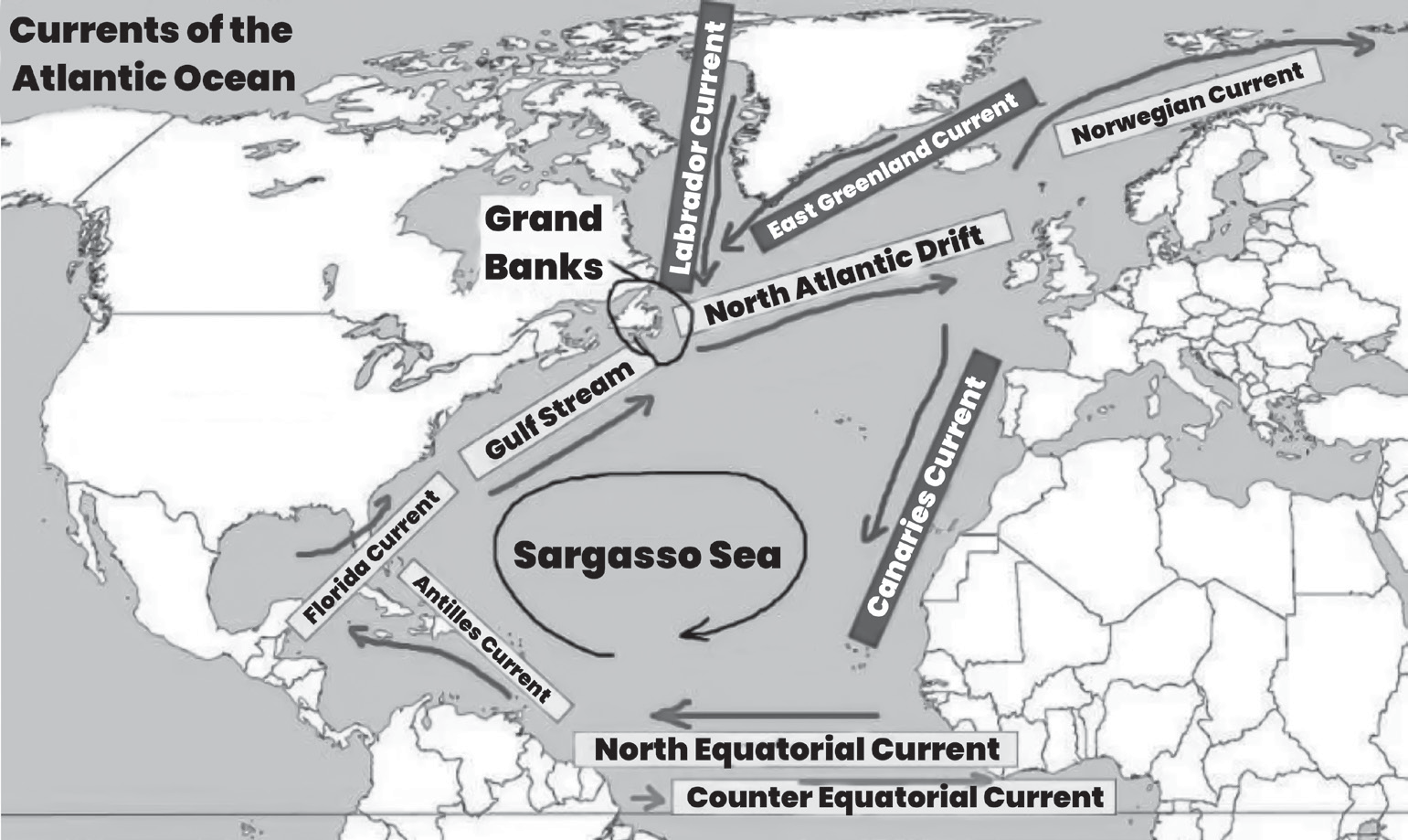
(Fig- Atlantic Ocean Currents)
Currents of Indian Ocean
The unique geography of the Indian Ocean, being only half an ocean and largely landlocked in the north, results in a distinct pattern of current circulation compared to the Atlantic or Pacific Ocean. In the northern portion of the Indian Ocean, the currents exhibit a different behavior from the general circulation pattern found elsewhere. This is largely due to the influence of the seasonal monsoons, which cause the currents to change direction from season to season.
The effect of winds on the currents in the Indian Ocean is particularly pronounced. The seasonal monsoon winds play a significant role in shaping the movement and behavior of the ocean currents. As the monsoon winds shift between seasons, they exert varying degrees of force on the surface waters, leading to changes in current direction and strength.
Major currents of the Indian Ocean include
North-East Monsoon Current (Warm)
• During the winter season in the northern hemisphere, the North-east monsoon winds blow from land to the ocean in the Indian Ocean.
• These westward-blowing North-east monsoon winds generate warm currents in the Indian Ocean, flowing to the south of 5 N latitude.
• Additionally, independent currents originate in the Bay of Bengal and Arabian Sea and flow in a south-westerly direction.
Indian Counter Current (Warm)
• The Indian counter current is formed during the winter season in the northern hemisphere.
• This warm current flows in an easterly direction between
2 -8 S latitudes, extending from Zanzibar to Sumatra.
S.W. Monsoon Current (Warm)
• There is a complete reversal in the direction of monsoon winds during the summer season in the Indian Ocean.
The north-easterly direction of the winter monsoon winds transforms into a south-westerly direction during the summer season in the northern hemisphere.
This reversal of monsoon winds also reverses the direction of ocean currents in the Indian Ocean during the summer season. The North-east monsoon ocean currents disappear, and south-west monsoon ocean currents emerge.
The general direction of the monsoon currents is from south-west to north-east, but several minor branches emerge from the main branch and move in the Bay of Bengal and Arabian Sea. The Indian counter current, developed during the winter season, disappears due to these changes.
South Equatorial Current (Indian Equatorial Current) (Warm)
The Indian Equatorial current is a warm ocean current that flows from east to west between 10 S to 15 S latitudes, extending from the Australian coast to the African coast.
After encountering Madagascar, this current is divided into multiple branches. One major branch flows southward as the Agulhas current, while the other branch moves northward.
Mozambique Current (Warm)
One of the branches of the South Equatorial current flows through the Mozambique Channel, forming the Mozambique Current.
The Mozambique Current joins the Agulhas Current near 30 S latitude, flowing up to the southern tip of Africa before being diverted eastward.
The West Wind Drift (Cold)
The West Wind Drift is a cold ocean current generated by the eastward-blowing westerlies along the 40 S latitude, known as the roaring forties.
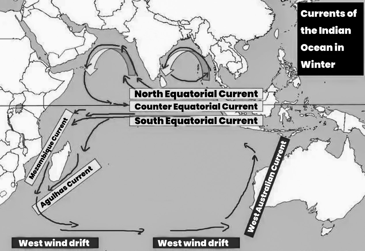
(Fig- Indian Ocean Currents)
• This current bifurcates into two branches near 110 E longitude. One branch turns northward, flowing as the West Australian cold current along the western coast of Australia. Near the Tropic of Capricorn, it turns west and northwest, ultimately merging with the South Equatorial Current near 100 E longitude.
• The second branch of the West Wind Drift turns southward.
Effects of Warm & Cold Ocean Currents
Effects of Warm & Cold Ocean currents
Ocean currents influence the climate and environmental conditions of adjacent lands.
Effects of warm ocean currents
Warm ocean currents contribute to warmer conditions in adjacent areas by raising the temperature. Winds passing over warm currents become heated, and when they reach coastal regions, they bring warmer conditions. For example, the North Atlantic Drift warms the coasts of Portugal, France, Britain, and the Netherlands, preventing them from icing over in winter. Durban, situated along the warm Mozambique Current, experiences temperatures around 24.4 C, while Port Nolloth, along the cold Benguela Current at the same latitude, has temperatures around 15.5 C.
Warm ocean currents enhance rainfall on coastal lands nearby. The high rate of evaporation over warm currents leads to increased moisture in the air. Winds carrying this moisture rise, cool, and condense, forming rainfall. Examples include heavy rainfall along the East African coast due to the warm Mozambique Current and along the West African coast due to the warm Guinea Current. For instance, Beira receives 1,521 mm and Durban receives 1,008 mm of rainfall annually.
Warm ocean currents create humid conditions in adjacent areas due to their association with higher temperatures. This high humidity contributes to the overall humidity levels in surrounding regions, such as the Natal Province of South Africa and the coasts of Western Europe.
Warm ocean currents influence wind temperatures, resulting in warm winds. Winds originating from areas with warm currents are known as warm maritime winds.
Warm ocean currents contribute to increased cloud cover over adjacent coastal lands due to high evaporation rates. The water vapor rises, cools, and condenses into dense clouds, such as cumulonimbus clouds, leading to heavy rainfall.
Effects of cold ocean currents
Cold ocean currents influence the climate and environmental conditions of the adjacent land masses in the following ways
Cold ocean currents regulate the temperatures of nearby land masses due to interactions with land and sea breezes. For example, the Benguela Current lowers temperatures
in surrounding areas of Namibia. Walvis Bay, influenced by the Benguela Current, has temperatures around 16 C, whereas Durban, at a similar latitude, experiences temperatures around 25 C.
Cold ocean currents contribute to arid conditions or the formation of marine deserts along adjacent coastal lands. Limited evaporation over these currents means winds passing over them pick up minimal moisture. Additionally, offshore winds prevent significant condensation and rainfall. Examples of marine deserts include the Namib Desert, influenced by the cold Benguela Current, the Californian Desert affected by the cold Californian Current, and the Atacama Desert due to the cold Peruvian Current.
Cold ocean currents result in low humidity levels due to reduced evaporation rates. This limited evaporation leads to sparse cloud cover, as there is insufficient atmospheric moisture.
Cold ocean currents lead to the formation of cold offshore fog or misty conditions, primarily due to rapid radiation cooling. In some cases, slightly warmer air blowing over cold ocean currents can result in steam fog formation. For example, San Francisco in southern California and the Labrador region in eastern Canada frequently experience foggy conditions due to these phenomena.
Effects of ocean currents on human activities along the coastal areas
The nature of ocean currents has influenced human activities in the coastal regions. It can be grouped into two categories-
(A) Effects of warm ocean current and (B) Effects of cold ocean current.
Effects of warm ocean currents
Increased rainfall resulting from warm ocean currents supports crop cultivation or rain-fed agriculture. Along the East African coast and West African coast, where warm currents prevail, various crops such as cloves, sisal, sugarcane, and cocoa are cultivated. For instance, Ghana’s cocoa production benefits from the high rainfall along the West African coast.
High rainfall encourages the growth of forests, leading to forestry activities in regions influenced by warm ocean currents. In countries like Gabon and along the East African coast, forestry activities such as lumbering are practiced, particularly in mangrove forests.
Warm conditions along the East African coast foster the growth of coral polyps, contributing to the formation of coral rocks and landforms such as coral reefs. These reefs serve as potential sources for coral limestone, used in
cement production (e.g., Bamburi cement). Additionally, coral reefs attract tourists, promoting tourism activities along the East African coast. However, they can hinder deep-sea fishing activities due to their presence.
Heavy rainfall associated with warm ocean currents may lead to thunderstorms, which can be destructive to crops, property, and infrastructure. These storms disrupt economic activities and pose risks to livelihoods in affected regions.
Effects of cold ocean currents
• Arid conditions resulting from cold ocean currents foster the growth of short grass pastures, facilitating pastoralism. Semi-arid regions like the Namib Desert and Kalahari Desert are conducive for pastoral activities due to the availability of grazing lands.
• Arid or desert conditions promoted by cold ocean currents have become tourist attractions, leading to the designation of such areas as wildlife conservation sites. For example, the Namib Desert in Namibia is renowned for its unique landscapes and biodiversity, attracting tourists interested in wildlife safaris and desert experiences.
The arid or desert conditions created by cold ocean currents provide suitable environments for the film industry. Filmmaking often takes place in these areas due to their distinctive landscapes and atmospheric qualities. The Namib Desert, for instance, has served as a backdrop for various movies and commercials.
Cold ocean currents cause upwelling of nutrient-rich ocean waters, fostering the growth of plankton and supporting thriving fishing industries. The upwelling brings nutrients like phosphates and nitrates to the surface, creating ideal conditions for plankton growth. Coastal waters affected by cold currents, such as those off the coasts of Morocco, South Africa, Angola, and Mauritania, are known for their abundant fish stocks and productive fisheries.
Cold ocean currents contribute to the formation of fog, reducing visibility over water and in the air, which can hinder navigation and aviation activities. Foggy conditions caused by cold currents pose challenges for maritime navigation and aviation operations in affected regions.