Major Oceans
INTRODUCTION
Oceanography includes the comprehensive study of the various aspects of oceans, including its physical, chemical and biological characteristics. It delves into the ocean’s ancient history, its current state and its potential future developments.
With the ocean covering approximately 71% of the Earth’s surface and containing an astounding 97% of the planet’s water, its significance cannot be overstated. One of its crucial roles is its contribution to the storage and redistribution of heat energy across the planet. The movement of heat through local and global ocean currents plays a vital role in regulating local weather patterns, moderating temperature extremes and stabilizing global climate patterns. Additionally, ocean currents facilitate the cycling of gases and the distribution of essential nutrients and larvae to marine ecosystems, influencing their health and biodiversity.
MAJOR OCEANS
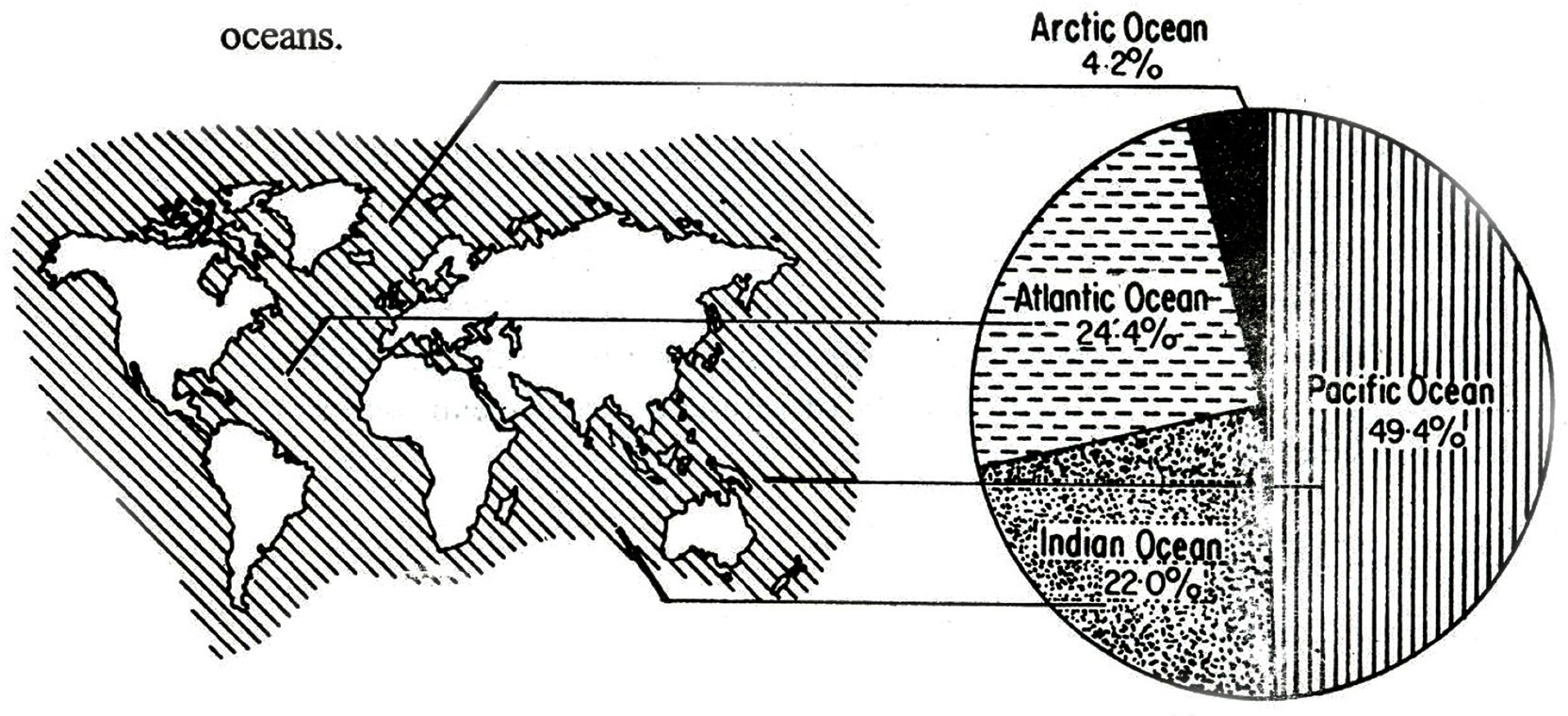
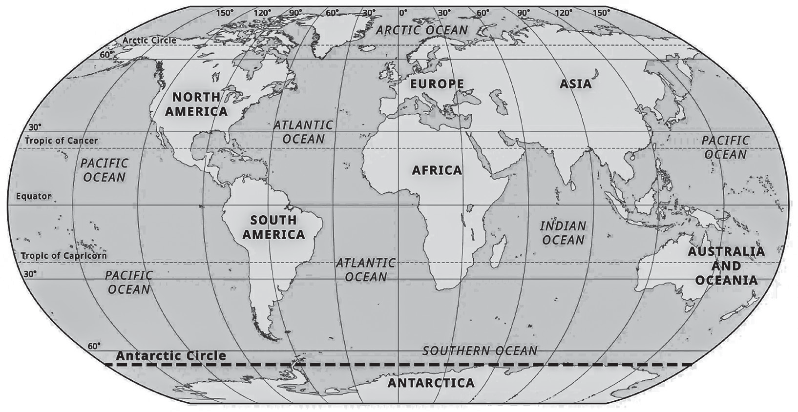
Historically, the Earth’s oceans were traditionally divided into four main bodies of water: the Atlantic, Pacific, Indian, and Arctic oceans. These distinctions were based on geographical and navigational conventions. However, in recent times, there has been a growing recognition of the Southern Ocean, also known as the Antarctic Ocean, as a distinct and separate entity. Many countries, including the United States, now recognize the Southern Ocean as the fifth ocean.
Pacific Ocean
The Pacific Ocean is the largest and deepest ocean on Earth, covering more than 30% of the planet’s surface. It is so vast that it holds close to half of the world’s water. Geographically, the Pacific Ocean borders the west coast of the Americas, stretches across East Asia and reaches Australia.
This immense body of water is divided by the equator into two main parts: the North Pacific Ocean and the South Pacific Ocean. It extends approximately 15,500 kilometers from the Bering Sea in the Arctic to the icy waters of Antarctica’s Ross Sea in the south. Notably, at
5 N latitude, the Pacific Ocean reaches its widest point, spanning a distance of about 19,800 kilometers from Indonesia to the Colombian Coast. Its farthest western point is believed to be the Strait of Malacca.
One of the most remarkable features of the Pacific Ocean is the Mariana Trench, located in the western Pacific near the Mariana Islands. It is the deepest part of the ocean, plunging to depths of approximately 11 kilometers below sea level.
The Pacific Ocean is also known for its vast archipelagos, including about 25,000 islands scattered throughout its waters. These islands are home to diverse ecosystems and cultures, making the Pacific region rich in biodiversity and human history.
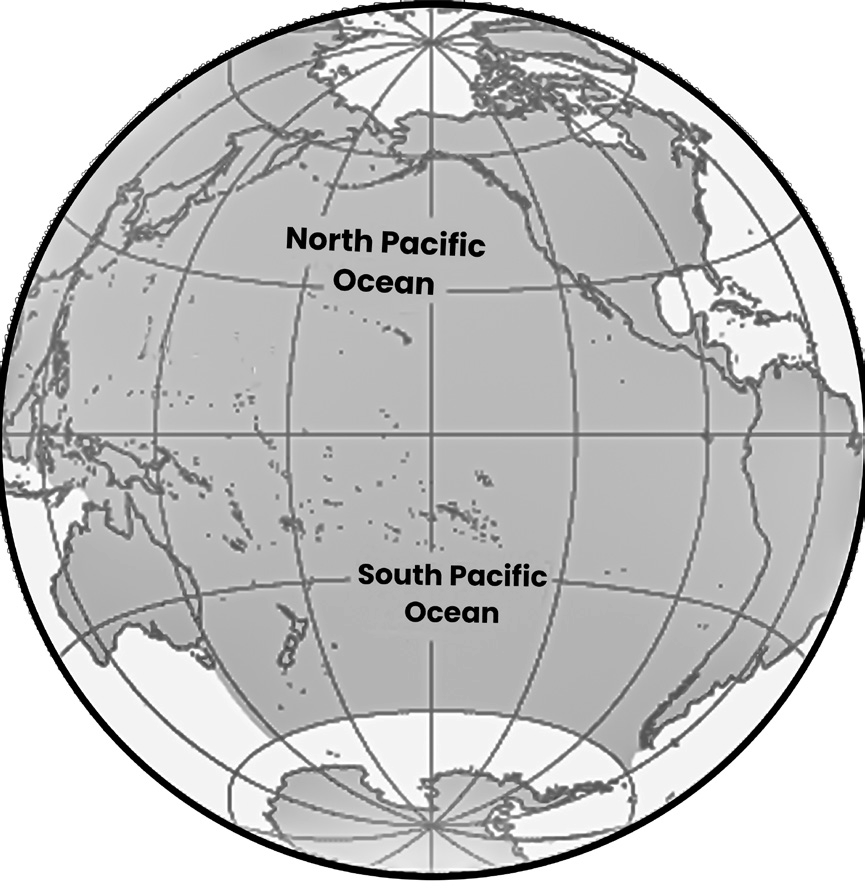
(Fig- The Pacific Ocean)
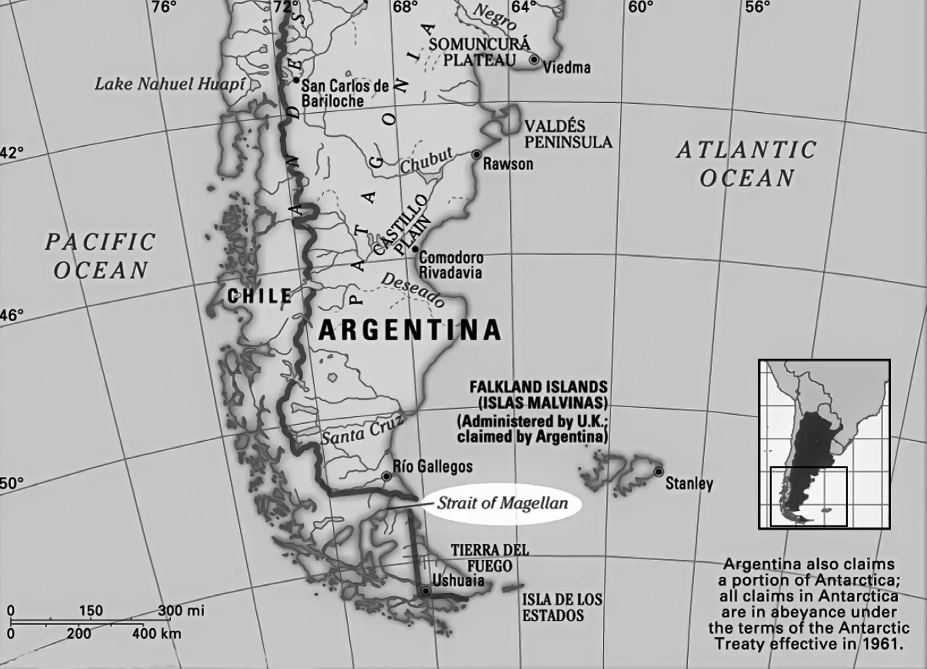
The largest seas of the Pacific include: the Celebes Sea, Coral Sea, East China Sea, Sea of Japan, South China Sea, Sulu Sea, Tasman Sea and Yellow Sea.
The Pacific and Indian Oceans are connected by the Strait of Malacca in the west while the Pacific and Atlantic Ocean are connected by the Strait of Magellan in the east.
The South China Sea
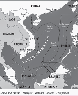
The South China Sea holds significant strategic and economic importance due to its abundance of natural resources, its role as a major shipping lane and its status as a militarized zone.
The South China Sea is rich in oil, natural gas, fish, and minerals, making it a valuable resource for the countries in the region. Access to these resources is crucial for economic development and energy security.
Multiple countries, including China, Vietnam, the Philippines, Taiwan, Malaysia and Brunei, have overlapping territorial claims in the South China Sea. These claims often overlap with Exclusive Economic Zones (EEZs) designated by international law.
The South China Sea is a vital fishing ground, and countries in the region have competing claims to fishing rights. This has led to disputes over access to fishing areas and the depletion of fish stocks.
As one of the busiest shipping lanes in the world, the South China Sea is crucial for international trade. A significant portion of global trade passes through these waters, making freedom of navigation a priority for many countries.
China’s assertive actions in asserting its sovereignty over the South China Sea, including the construction of artificial islands and military installations, have raised tensions in the region. The militarization of disputed islands has sparked concerns among neighboring countries and the international community about potential conflicts.
The Spratly and Paracel Islands are among the most- contested areas in the South China Sea, with multiple countries claiming sovereignty over them. These disputes have led to diplomatic tensions, naval standoffs and occasional skirmishes.
The disputes in the South China Sea are governed by international maritime law, including the United Nations Convention on the Law of the Sea (UNCLOS). However, interpretations of UNCLOS and adherence to its provisions vary among the countries involved, leading to disagreements over maritime boundaries and rights
Atlantic Ocean
• The Atlantic Ocean is the second-largest ocean in the world, covering a significant portion of the Earth’s surface. It lies between the Americas to the west and Europe/Africa to the east.
• The Atlantic Ocean resembles an S-shape, extending from north to south and divided into the North Atlantic and South Atlantic by counter currents at the equator. Its geography includes a vast basin with the mid-Atlantic Ridge, a submarine mountain range extending from Iceland to about 58 degrees South latitude.
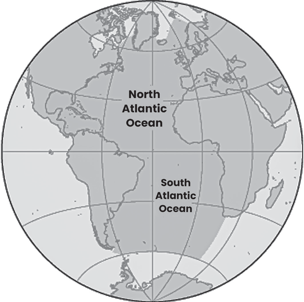
(Fig- The Atlantic Ocean)
• The Atlantic Ocean is connected to the Pacific Ocean via the Arctic Ocean in the north and the Southern Ocean in the south. It is separated from the Indian Ocean by the
20 East Meridian. The Arctic Ocean is delineated from the Atlantic by a line from Greenland to southernmost Svalbard to northern Norway.
• The ocean bottom features notable formations such as the Mid-Atlantic Ridge, which extends along most of its length, and the Walvis Ridge in the South Atlantic. The Mid-Atlantic Ridge includes a rift valley and underwater mountain peaks, some of which rise above the surface to form islands.
• The coasts of the Atlantic Ocean are characterized by numerous bays, gulfs, and seas, including the Caribbean Sea, Gulf of Mexico, Gulf of St. Lawrence, Mediterranean Sea, Black Sea, North Sea, Baltic Sea and Norwegian- Greenland Sea.
• The Atlantic Ocean is home to a variety of islands, including Svalbard, Greenland, Iceland, Great Britain, Ireland, the Azores, the Canary Islands, the Cape Verde Islands, Bermuda, the West Indies, Ascension, St. Helena and the Falkland Islands, among others.
• The Atlantic Ocean features some of the world’s widest shelves, such as the Dogger Bank and Grand Bank, which are important for marine biodiversity and fisheries.
Indian Ocean
• The Indian Ocean is the third-largest ocean globally, covering approximately 20% of the Earth’s water surface. It is the youngest of the five oceans, characterized by spreading ridges at divergent plate boundaries.
• The Indian Ocean is bounded by southern Asia to the north, the Arabian Peninsula and Africa to the west, the Malay Peninsula, Sunda Islands, and Australia to the east, and the Southern Ocean to the south. It is separated from the Atlantic Ocean by the 20 east meridian and from the Pacific Ocean by the 147 east meridian.
• The Indian Ocean extends to about 30 N latitude at its
northernmost point, reaching the Persian Gulf.
• The Indian Ocean is home to numerous islands, including Madagascar (the world’s fourth-largest island), Comoros, Seychelles, Maldives, Mauritius, Sri Lanka, and Indonesia. These islands are situated around the continental rims.
• Beneath the surface of the Indian Ocean lies the convergence of the African, Indian, and Antarctic crustal plates. This convergence is marked by the Y-shaped branches of the Mid-Oceanic Ridge and a stem running south from the edge of the continental shelf near Mumbai, India.
• Several large rivers flow into the Indian Ocean, including the Zambezi, Arvandrud/Shatt-al-Arab, Indus, Ganges, Brahmaputra and the Irrawaddy. The monsoon seasons play a significant role in controlling the currents within this oceanographic region.
• The Indian Ocean features two main currents: one flows clockwise in the northern hemisphere, while the other
flows counterclockwise south of the equator. These currents are influenced by the monsoon seasons and play a crucial role in regulating climate patterns and marine ecosystems in the region.
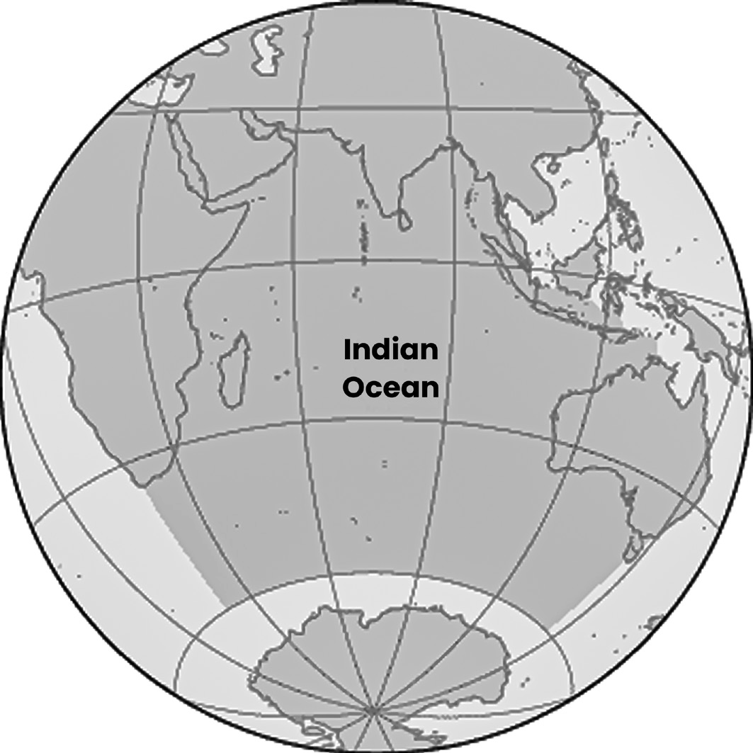
(Fig- The Indian Ocean)
Sea
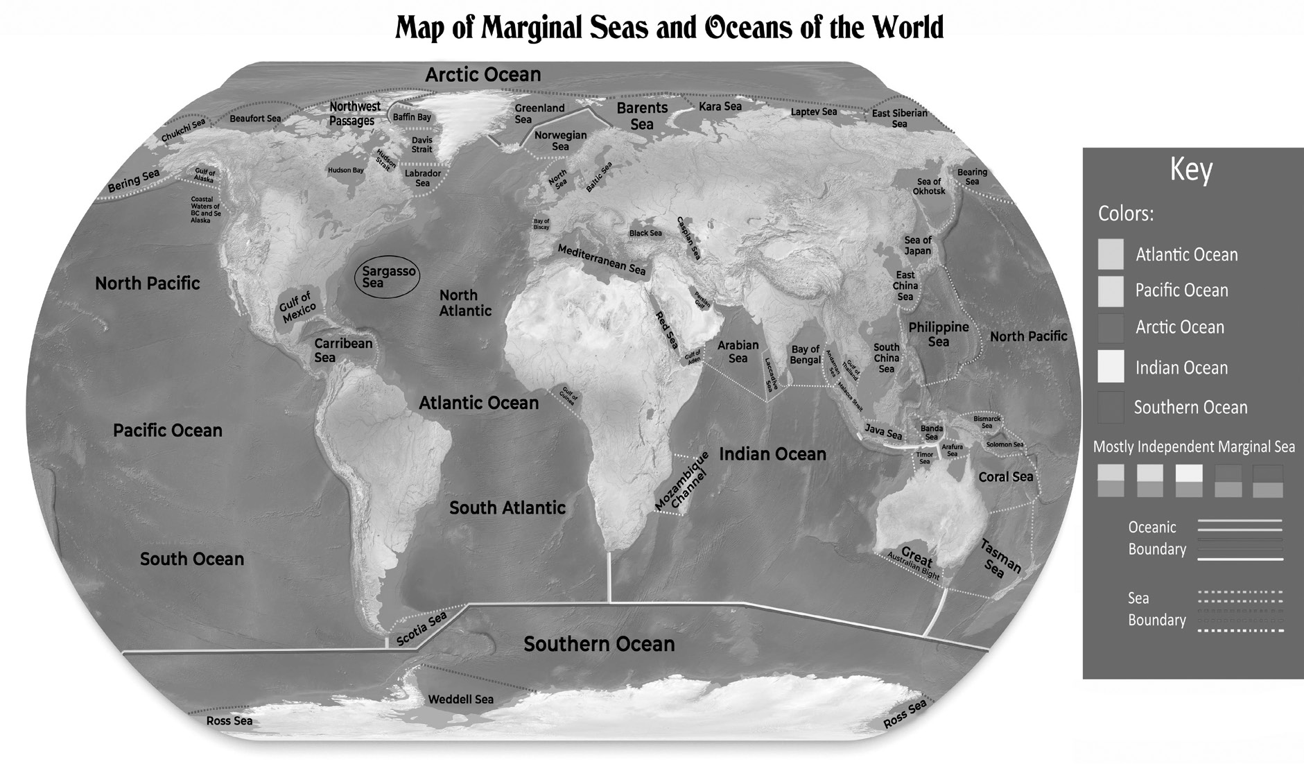
MARGINAL SEA
• A marginal sea is a geographical term referring to a division of an ocean that is partially enclosed by landmasses such as islands, archipelagos, or peninsulas. Marginal seas can either be widely open to the open ocean at the surface or bounded by submarine ridges on the sea floor.
• Marginal seas are typically large, shallow bodies of water located along continental edges or margins. Examples of marginal seas include the Arabian Sea, Baltic Sea, Bering Sea, Beaufort Sea, Black Sea, Gulf of California, Gulf of Mexico, Red Sea and Mediterranean Sea.
• Marginal seas share similarities with open oceans in terms of being created by large-scale geological processes, exhibiting biodiversity and possessing layered water circulation patterns.
• The degree of water circulation between marginal seas and open oceans can vary depending on their location and geographic features.
• While marginal seas and open oceans share many characteristics, there are some primary differences between them. Marginal seas are generally shallower than open oceans and are more influenced by factors such as human activities, river runoff, climate and water circulation patterns. These influences can lead to differences in environmental conditions and ecological dynamics between marginal seas and open oceans.
Mediterranean Sea
The Mediterranean Sea is a significant body of water surrounded by diverse countries and with historical and geographical importance.
The Mediterranean Sea is divided into two sub-basins by a 400-meter sill. It is connected to the Atlantic Ocean via the Straits of Gibraltar, to the Black Sea via the Bosporus Strait, and to the Red Sea via the man-made Suez Canal.
Atlantic Ocean water enters the Mediterranean Sea through the Straits of Gibraltar as a surface flow, replenishing some of the water lost through evaporation, especially in the eastern Mediterranean.
Due to higher evaporation rates compared to precipitation, the Mediterranean Sea experiences an increase in salinity. This high salinity has ecological implications for marine life in the region.
The coastal region of the eastern Mediterranean, known as the Levant, has been a crossroads of various peoples and cultures since ancient times. This area has played a crucial role in trade and cultural exchange, leading to significant social and economic changes across the Middle East and Mediterranean regions.
The Mediterranean Sea is bordered by 21 countries, each contributing to the region’s cultural diversity and geopolitical significance. These countries include Albania, Algeria, Bosnia and Herzegovina, Croatia, Cyprus, Egypt, France, Greece, Israel, Italy, Lebanon, Libya, Malta, Monaco, Montenegro, Morocco, Slovenia, Spain, Syria, Tunisia and Turkey.
Human Impacts
• Coastal waters and marginal seas serve as vital resources for human activities, including food production, energy extraction, and various recreational and scientific endeavors. However, these areas are particularly vulnerable to human impacts and pollution due to their proximity to landmasses and high levels of human activity.
• Approximately ninety percent of the world’s fisheries are located within coastal waters less than 200 kilometers (124 miles) from shorelines. The intense fishing activity in these areas puts significant pressure on marine ecosystems and can lead to overfishing and depletion of fish stocks.
• Industrial activities such as sewage disposal, dredging activities offshore oil drilling and accidental releases of pollutants pose serious threats to marginal seas. These activities introduce various pollutants, including petroleum products, radioactive waste, detergents and plastics, which can have detrimental effects on marine life and ecosystems.
• Coastal waters and marginal seas are more susceptible to pollution compared to open ocean regions due to the concentration of human activities near coastlines and rivers. Pollutants from landmasses are discharged into marginal seas at concentrations much higher than those found in open oceans, primarily through water discharge and airborne deposition.
• Pollutants introduced into marginal seas can either stimulate or inhibit the growth of marine organisms depending on their nature and concentration. For example, the discharge of domestic sewage can lead to elevated nutrient concentrations, stimulating the growth of phytoplankton. However, this increased productivity may also result in harmful algal blooms, which can have adverse effects on marine ecosystems and human health.
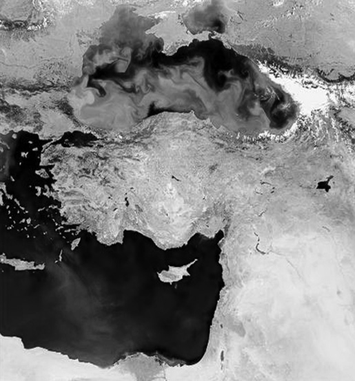
Fig-The Mediterranean Sea and the Black Sea are marginal seas found in proximity to one another. The color difference shown here is due to a phytoplankton bloom occurring in the Black Sea).
Biomass Production and Primary Productivity
• Biomass in marine ecosystems encompasses various organisms, including plants (phytoplankton), herbivores (zooplankton), carnivores (fish, marine mammals) and omnivores. The overall biomass is a measure of the total living organic matter present in a given ecosystem.
• Primary productivity forms the foundation of marine food webs by converting inorganic compounds (such as carbon dioxide and nutrients) into organic matter through photosynthesis. The availability of sunlight, carbon dioxide, nutrients (such as nitrates and phosphates) and trace elements influences primary productivity rates.
• Marginal seas generally exhibit intermediate levels of primary productivity, with coastal upwelling regions experiencing the highest rates and open ocean regions having the lowest rates. Marginal seas fall between these extremes, with primary productivity influenced by factors such as nutrient availability and physical processes.
• Regional variations in primary productivity are influenced by water column chemistry and dominant physical processes. Nearshore regions, including coastal waters and marginal seas, are affected by factors such as river runoff, water column mixing and turbidity.
• River runoff and water column mixing introduce dissolved nutrients and trace elements into nearshore regions, promoting primary productivity. However, the addition of suspended particles from runoff can increase water turbidity, reducing sunlight penetration and thus inhibiting primary productivity.
Water Circulation in Marginal Seas
Water circulation patterns in marginal seas are influenced by various factors, primarily bathymetry, fresh-water input, and evaporation.
• Bathymetry refers to the study of the underwater topography or terrain.
• Freshwater input into marginal seas comes from sources such as river runoff and precipitation.
Evaporation refers to the process by which water vaporizes into the atmosphere from the sea surface. In regions where evaporation exceeds river runoff and precipitation, such as the Mediterranean Sea, the marginal sea water becomes saltier. The increased salinity causes the water to become denser, leading it to sink and flow towards the less salty open ocean regions.
While these general circulation patterns exist, they are often modified by the local bathymetry of the marginal seas. Submarine features can act as barriers or channels, influencing the direction and intensity of currents. For example, underwater ridges may restrict the flow of water, while channels or gaps in the seabed may facilitate the movement of water.
The water circulation patterns of four major marginal seas are described below:
The Mediterranean Sea:
• Thermohaline circulation drives water flow, influenced by density variations due to temperature and salinity differences.
• Intense evaporation leads to increased surface water salinity, causing dense surface water to sink and form bottom water.
• Dense bottom water flows out into the Atlantic Ocean basin through the Strait of Gibraltar, while less dense Atlantic water flows into the Mediterranean to replace evaporated water.
• A net movement of water into the Mediterranean occurs due to water loss by evaporation.
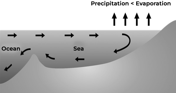
(Fig-Thermohaline circulation in the Mediterranean Sea is driven by high rates of evaporation. Salty dense water sinks and less dense water from the Atlantic Ocean basin flows into the sea.)
Black and Baltic Seas:
• Circulation patterns are influenced by freshwater input exceeding evaporation, resulting in less dense surface water.
• Freshwater runoff from rivers contributes to brackish surface water.
• Less salty surface water flows out of the seas, while saltier water from the Atlantic basin flows in along the bottom.
• Subsurface water circulation is restricted by sills, potentially leading to stagnation and local oxygen depletion.
Gulf of Mexico
• The Gulf of Mexico has a less complex circulation pattern compared to other seas.
• It is characterized by an extensive continental shelf and moderate water depths.
• Surface water salinity ranges from 36.0 to 36.3 ppt, influenced by factors like Mississippi River runoff.
• The Loop Current is a unique feature, driven by the Caribbean Current, which enters through the Yucatán Strait and circulates clockwise around a warm “dome” of surface water.
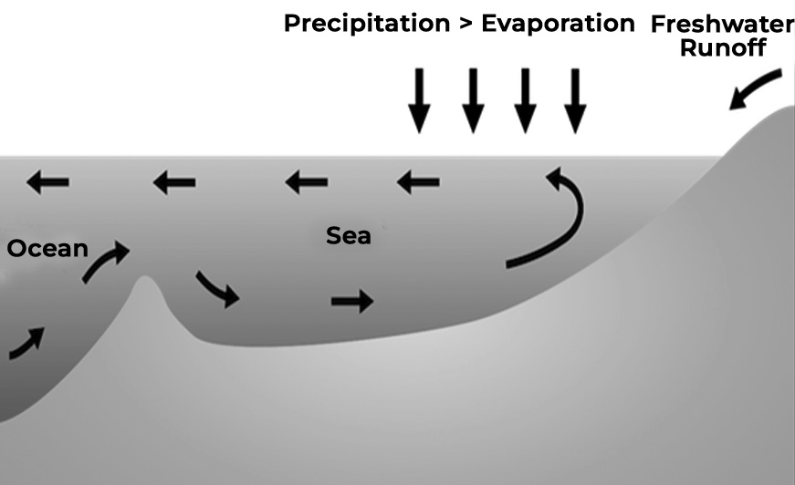
Fig-Thermohaline circulation in the Baltic Sea is driven by high rates of precipitation and runoff. Less dense water flows out of the sea on the surface and denser water flows in along the ocean floor.)
Bays, Gulfs, Straits and Isthmus
BAYS, GULFS, STRAITS AND ISTHMUS
Bays, gulfs, and straits are all significant geographical features found near land within larger bodies of water. They play crucial roles in various human activities such as shipping, fishing, and tourism due to their accessibility and strategic locations. However, their importance can also lead to conflicts between different countries or communities regarding their use, management, and environmental impact.
Bays
A bay is described as a small body of water or a broad inlet that is separated from a larger body of water by the curving of the land inward.
Examples of Bays:
San Francisco Bay: Located in northern California.
Bay of Pigs: Situated in Cuba.
Hudson Bay: Found in Canada.
Chesapeake Bay: Located in Maryland and Virginia.
Bay of Bengal: Situated near India.
All bays play a crucial role in maintaining the health of the surrounding environment. The health of bays can be compromised when foreign materials are introduced into the water flowing into the bay or directly into the bay itself. It is extremely important to take care of bays to ensure their continued health and functioning.
Gulfs
Gulfs are large bodies of water almost entirely surrounded by land, akin to large bays.
The Gulf of Mexico stands out as the world’s largest gulf, bordered by Mexico, the southern United States coast and Cuba. It encompasses various bays, including Matagorda Bay and Mobile Bay.
Other notable gulfs include the Gulf of California, the Gulf of Aden (between the Red Sea and the Arabian Sea) and the Persian Gulf (between Saudi Arabia and Iran). The Persian Gulf holds significant importance in global energy due to the transportation of petroleum via oil tankers.
Hypoxia, a condition marked by depleted oxygen levels in water, poses a significant environmental challenge in the Gulf of Mexico. This phenomenon has been documented off the coast of Louisiana, leading to the emergence of where most aquatic species struggle to survive. Hypoxia is primarily attributed to excessive nutrient pollution, leading to algae overgrowth and subsequent oxygen depletion upon decay. The persistence of hypoxic zones could threaten the economy of the United States, given the Gulf’s importance in fisheries, tourism and shipping industries.
Straits
A strait is a narrow water passage typically found between continents or islands, or connecting two larger bodies of water. The most famous strait is the Strait of Gibraltar, which links the Atlantic Ocean to the Mediterranean Sea and separates northern Africa from the southernmost point of the Iberian Peninsula. Historically, the Strait of Gibraltar served as a crucial route for commerce between the Mediterranean Sea and the Atlantic Ocean and remains vital for international trade today.
Two other notable straits include the Strait of Bosporus, connecting the Black Sea to the Sea of Marmara and splitting
northwestern Turkey, and the Strait of Hormuz, located at the southeastern end of the Persian Gulf. The latter has gained significance due to its strategic location and the potential for it to be controlled to restrict ship movement.
Choke points are bodies of water, like straits, that can be blocked or closed to control transportation routes. Historically, the Strait of Gibraltar has been one of the world’s most important choke points. However, the Strait of Hormuz has gained prominence in recent years due to escalating tensions in the Middle East. Surrounded by the United Arab Emirates, Oman and Iran, the Strait of Hormuz connects the Persian Gulf to the Arabian Sea and the Indian Ocean.
Isthmus
An isthmus is a narrow strip of land that connects two larger landmasses and separates two bodies of water. Isthmuses have been strategically important locations throughout history, serving as natural sites for ports, canals linking terrestrial and aquatic trade routes, and centers for communication, cultural exchange and military outposts.
The Isthmus of Panama in Panama connects the continents of North and South America, separating the Pacific and Atlantic Oceans. Similarly, the Isthmus of Suez in eastern Egypt connects Africa and Asia, separating the Mediterranean and Red Seas.
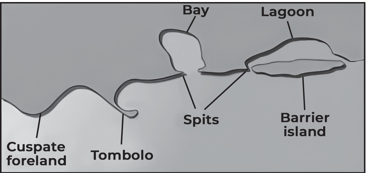
Tombolos are landforms created as tides and waves deposit sediment, forming a thin strip of land between a coastal island and the mainland. The island connected to the mainland by a tombolo is known as a tied island, as the built-up sandbar “ties” the island to the mainland. An example is Mount Maunganui in New Zealand, a tombolo town located on a sandbar connecting the volcanic island of Mauao to the mainland.