Whatsapp 88106-52225 For Details
Get Free IAS Booklet
Get Free IAS Booklet
VOLCANISM
Volcanism is a natural process that can cause significant and rapid changes to the Earth’s surface. It involves the movement and cooling of hot liquid rock called magma beneath the Earth’s surface, as well as its eruption onto the surface as lava. This process forms various features such as volcanoes, lava flows, and volcanic mountains.
• A volcano is like a big hole in the Earth’s surface. It has a circular or nearly circular opening called a vent. Through this vent, materials like hot gases, ash, water, and melted rock called lava come out from deep inside the Earth.
• When a volcano erupts, it spews out all these heated materials. The melted rock that flows out onto the Earth’s surface is called lava. As this lava and other materials pile up near the vent, they create a hill that looks like a cone.
• At the top of this cone-shaped hill is a depression called a crater, which is like a funnel-shaped hole. The bottom of the crater connects to the inside of the Earth through a tube called a volcanic pipe. This pipe allows the lava to rise up from below and reach the top of the volcano.
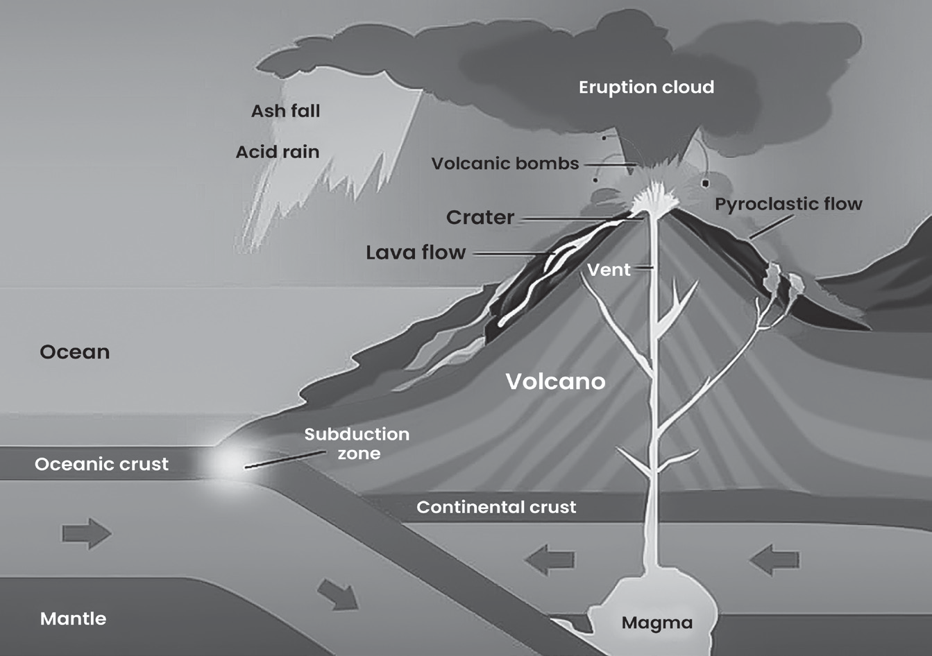
Fig- Various features of volcanic eruption
Types of Volcanoes
Volcanic eruptions come in different forms and happen at different times. The type of eruption, whether explosive or quiet, depends on the kind of magma involved.
Volcanoes are broadly classified into two main types based on how they erupt
• Central or explosive eruption: This type involves a powerful explosion from the volcano’s central vent.
• Fissure or quiet eruption: Here, the magma flows out from long cracks in the Earth’s surface, resulting in a gentler, quieter eruption.
When a volcano erupts explosively, it’s a stunning sight. It ejects out hot materials like lava and rock fragments, which can include solidified lava blobs, ashes and dust.
Volcanoes are categorized based on how often they erupt
• Active: These volcanoes erupt frequently.
• Dormant: These volcanoes are currently not erupting but have erupted in the past and could erupt again in the future.
• Extinct: These volcanoes are not expected to erupt again as they have been inactive for a long time.
Volcanoes of Central or Explosive Eruption
• Central or explosive volcanoes erupt by pushing out liquid lava, rock fragments, ash and small stones through a central vent or opening.
• After the eruption, these materials pile up around the vent, forming cone-shaped structures with craters at the top.
• In central eruptions, the intensity can vary depending on factors like the amount of material ejected, gas pressure and the thickness of the lava.
• There are two main types of lava: basic (also called mafic or basaltic) and acid (or felsic)
• Basic lava is less thick and flows easily, leading to quiet eruptions.
• Acidic lava, on the other hand, is thicker and can cause explosive eruptions.
Central eruption volcanoes can be further classified into five main types: Hawaiian, Strombolian, Vulcanian, Vesuvian, and Pelean, each with its own characteristics.
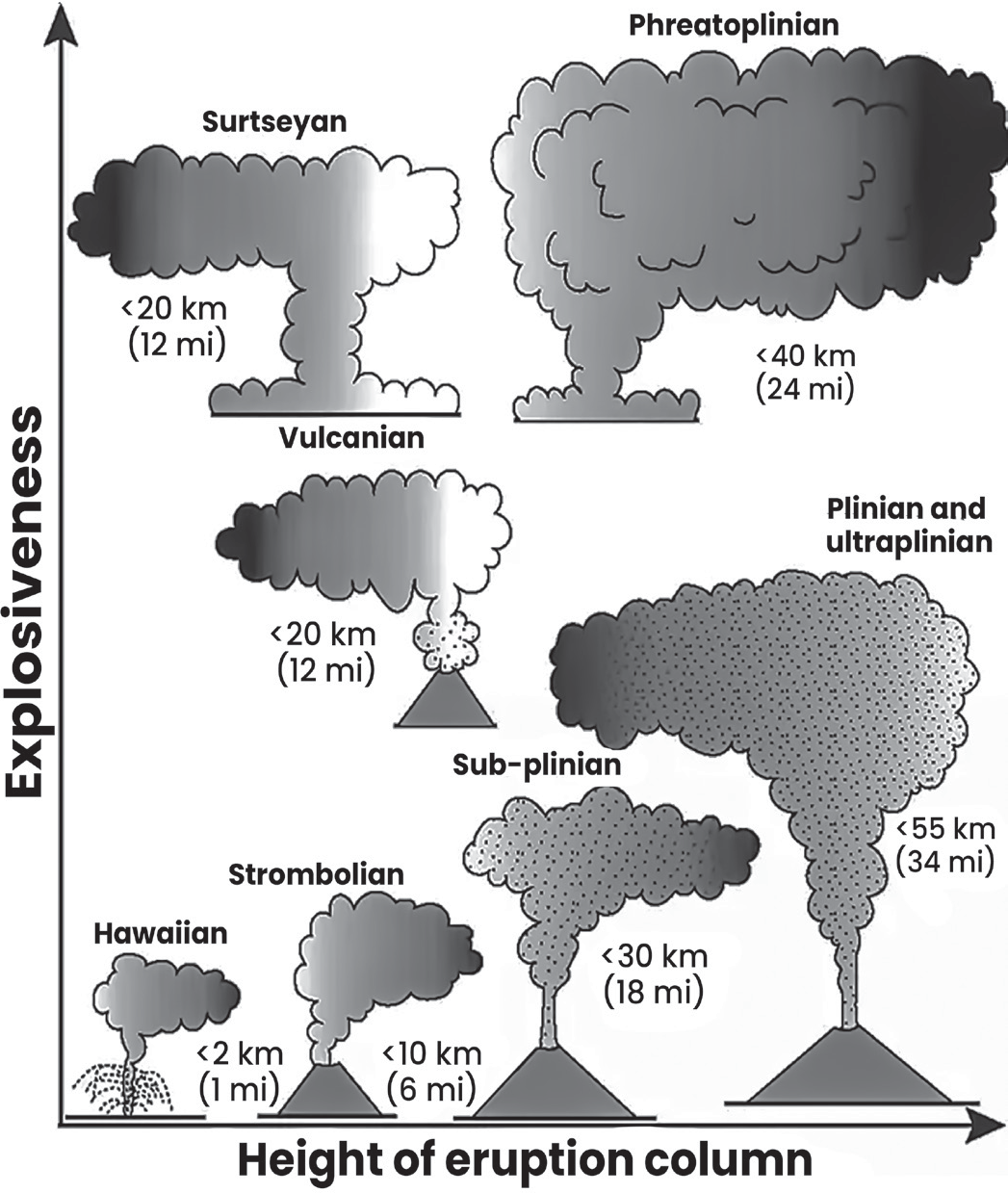
• Hawaiian type of volcanoes
• Hawaiian volcanoes have eruptions that are not very explosive and occur quietly. This is because the lava they produce is not very thick (Less Viscosity) and the gases are not violent.
• These eruptions are effusive, meaning they involve the slow release of lava onto the surface. They are among the simplest types of volcanic eruptions and can lead to large lava flows over time. There is usually very little or no volcanic ash produced during these eruptions.
• Strombolian type of volcanoes
• Strombolian volcanoes are named after the island of Stromboli in the Mediterranean Sea and are known for their picturesque eruptions.
• These eruptions are relatively mild, involving the ejection of liquid lava fragments such as pumice, scoria and hot material bombs when bubbles burst.
• The eruptions occur at regular intervals, ranging from a few minutes to about an hour.
• Strombolian volcanoes can eject materials hundreds to thousands of meters into the air, and they often produce unusual lava flows.
• When viewed at night, Strombolian eruptions resemble energetic Roman candle fireworks, earning them the nickname “Lighthouse of the Mediterranean.”
• Vulcanian type of volcanoes
• Vulcanian eruptions are named after the eruptions on Volcano Island in the Mediterranean and are more explosive than Strombolian eruptions.
• These eruptions involve thicker magma that quickly solidifies and blocks the volcano’s crater between eruptions.
• Because of this blockage, gases trapped in the magma struggle to escape during the next eruption. As pressure builds up, the gases forcefully explode through the solidified vent.
• Vulcanian eruptions emit a larger amount of ash and dust compared to Strombolian eruptions. This ash and dust can spread over hundreds of square kilometers in the atmosphere.
• Vesuvian type of volcanoes
• Vesuvian volcanoes have eruptions that are very violent, similar to Vulcanian and Strombolian eruptions.
• During these eruptions, lava is forcefully ejected from lateral cracks in the volcano, while intense gases accumulate in the main vent. When the pressure from these gases builds up, a rapid explosion occurs.
• The explosion produces thick clouds of ash and gases that resemble mushroom shapes and can rise to great heights in the sky.
• Pelean type of volcanoes
• These eruptions are named after the explosive eruption of Mt. Pelee in 1902 on Martinique Island in the Caribbean Sea.
• The eruption of Mt. Pelee was incredibly powerful and devastated the town of St. Pierre, killing all of its 30,000 residents. It’s considered one of the worst volcanic events of the twentieth century.
• These eruptions are highly explosive and involve thick, sticky lava.
• One of their characteristics is the presence of hot glowing clouds, called nuee ardente, which rush down the side of the volcano, burning everything in their path.
• Inside the volcano’s crater, the thick lava forms a dome-shaped structure.
Volcanoes of Fissure or Quiet Eruption
• In this type of eruption, vents appear as straight lines (Linear Features) on the Earth’s surface and lava erupts from faults or cracks without any explosive activity.
• These eruptions, known as fissure-fed eruptions, usually begin with a sheet of magma that erupts along the fault line. Unlike other eruptions, there is no central vent or pipe leading directly to the magma deep inside the Earth. This causes the magma to quickly spread out and form several smaller vents along the crack.
Classification based on Frequency of Volcanic Eruption
On the basis of frequency of eruption, volcanoes can be divided into three categories, namely active, dormant and extinct.
Active volcanoes
• These types of volcanic eruptions happen regularly, with lava, gases, ash and other materials erupting periodically.
• Examples of such volcanoes include Mona Loa in Hawaii, Etna in Sicily, Vesuvius in Italy, Pinatubo and Mayon in the Philippines and Barren Island in India. Cotopaxi Volcano in Ecuador is the world’s highest active volcano.
Dormant volcanoes
• Volcanoes can become quiet for a while after erupting, but there’s still a chance they could erupt again in the future.
• Some well-known examples of these types of volcanoes are Fujiyama in Japan and Krakatoa in Indonesia.
Extinct volcanoes
• When a volcano stops erupting completely and shows no signs of erupting again in the future, it is classified as an extinct volcano.
• In the case of extinct volcanoes, the crater may become filled with water, forming lakes.
Types of Lava
Volcanic eruptions can result in various phenomena including lava flows, lava domes, blasts, eruption columns, pyroclastic flows, lahars (mudflows) and landslides.
• Magma is extremely hot liquid and semi-liquid rock located beneath the Earth’s surface. The Earth has a layered structure consisting of the inner core, outer core, mantle, and crust, with much of the mantle comprising of magma.
• Magma can force its way through holes or cracks in the crust, leading to volcanic eruptions. When magma reaches the Earth’s surface, it’s called lava.
• Similar to solid rock, magma is composed of minerals but also contains small amounts of dissolved gases like water vapor, carbon dioxide and sulfur. The high temperatures and pressure beneath the Earth’s crust keep magma in its fluid state.
• There are three main types of magma: basaltic, andesitic and rhyolitic. Each type has a different mix of minerals. Regardless of the type, all magma contains a significant amount of silicon dioxide.
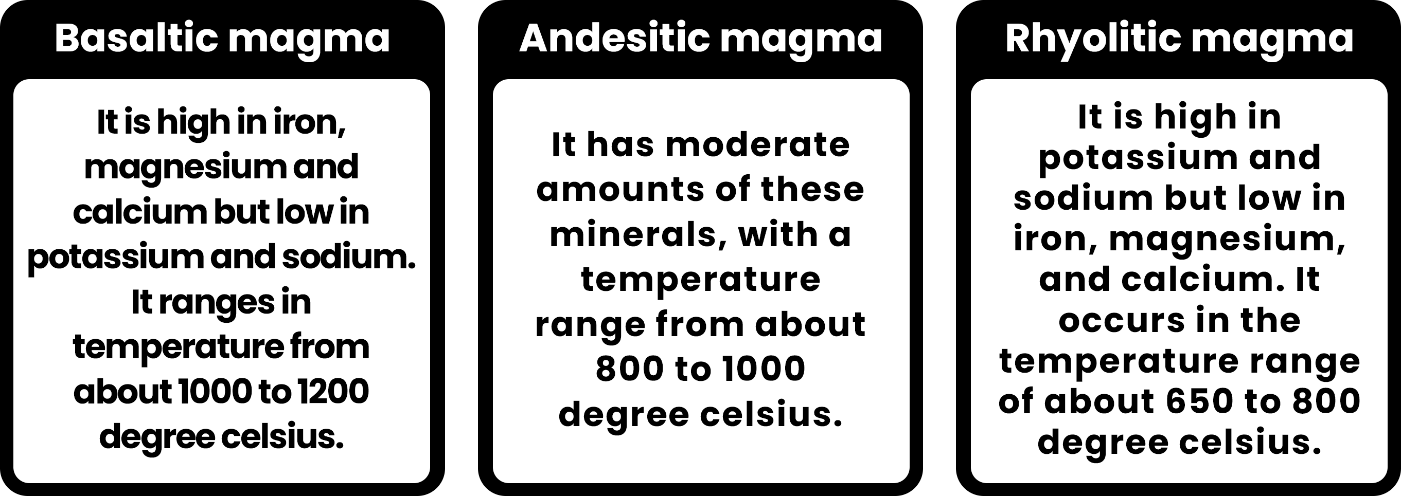
Volcano Structure
The temperature and mineral content of magma determine how easily it flows. Magma viscosity, or thickness, affects the shape of the volcano. Volcanoes with steep slopes form from thick magma, while flatter ones form from more fluid magma.
• Volcanic eruptions produce different materials that shape the landscape, including lava flows of varying viscosity and gas content, and tephra (rock fragments) of various sizes. Different volcanoes produce different materials, affecting their size, shape and structure.
• There are three main types of volcanoes: cinder cones (also called spatter cones), composite volcanoes (also called stratovolcanoes), and shield volcanoes. Each type varies in size and shape, as illustrated in the accompanying figure.
• Shield volcanoes are named for their broad, rounded shape, and they are the largest type of volcanoes. The largest volcano on Earth is Mauna Loa, which forms a significant portion of the Island of Hawai’i. It has a diameter of nearly 200 kilometers. While its summit rises 4,169 meters above sea level, Mauna Loa extends much deeper. It starts from the ocean floor at a depth of approximately 5,000 meters.
Due to its immense mass, the volcano has sunk further into the mantle, reaching a depth of an additional 8,000 meters. Altogether, Mauna Loa is made up of about 17,170 meters of accumulated rock.
K lauea Volcano is another example of a shield volcano, although it is much flatter compared to Mauna Loa. It only rises about 18 meters above the surrounding land and may not be easily noticeable on a diagram due to its low profile. However, it still stretches over a distance of 125 kilometers along the eastern side of the Island of Hawai’i.
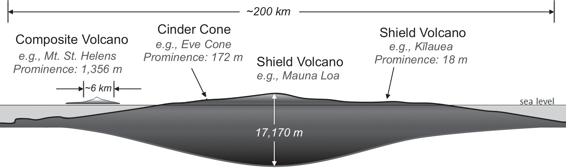
• Composite volcanoes are the second largest type of volcanoes. An example is Mt. St. Helens, located in the Cascade Range of the western United States. Mt. St. Helens rises 1,356 meters above the surrounding land and has a diameter of about 6 kilometers.
• Composite volcanoes typically have a conical shape, with steep sides that slope upward toward the summit.
• Unlike shield volcanoes, which are broader and flatter, composite volcanoes are generally no more than 10 kilometers in diameter.
• Cinder cones are the smallest type of volcanoes and are often difficult to see next to larger ones like Mauna Loa. An example is Eve Cone, located on the flanks of Mt. Edziza in northwestern British Columbia. Eve Cone rises 172 meters above the landscape and has a diameter of less than 500 meters.
Cinder cones have straight sides, unlike the steepening slopes of composite volcanoes or the rounded shape of shield volcanoes.
Volcanic Landforms
When magma rises from underground chambers and cools down, it can do so either within the Earth’s crust or on the surface. Rocks formed from the cooling of magma beneath the Earth’s surface are called plutonic rocks. Rocks formed from the cooling of magma on the Earth’s surface are called igneous rocks.
Volcanic landforms are features formed as a result of volcanic activity and depend on where the magma cools:
• Intrusive landforms are formed when magma cools and solidifies beneath the Earth’s surface.
• Extrusive landforms are formed when magma cools and solidifies on the Earth’s surface.
• Intrusive Volcanic Landforms
When magma cools and solidifies beneath the Earth’s crust, it forms intrusive landforms. These volcanic features are pushed into the lithosphere (the Earth’s outer shell) or existing rock layers. Over time, erosion and weathering wear away the overlying layers of rock, eventually exposing these intrusive features at the Earth’s surface.
Interestingly, most volcanic materials never reach the Earth’s surface in their molten state. Instead, they cool and solidify underground, forming the majority of volcanic features. Various features are-
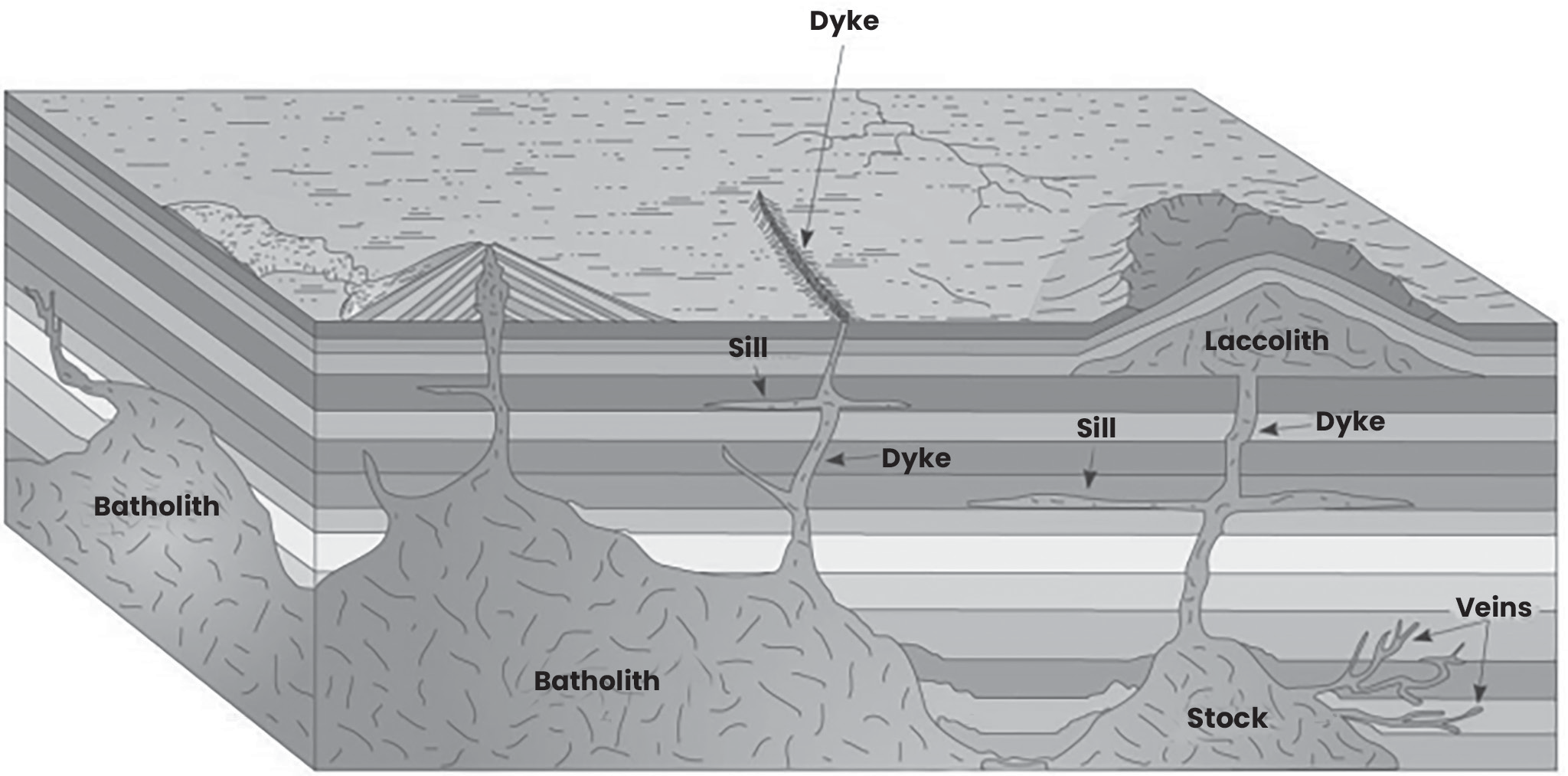
(Fig-Intrusive volcanic landforms)
Batholiths
• Batholiths are large bodies of cooled magma that form deep within the Earth’s crust.
• As the magma cools, it solidifies into a large dome-shaped structure.
• After the process of denudation, which is the wearing away of the Earth’s surface layers by erosion and weathering, batholiths become visible on the Earth’s surface.
• Batholiths often form the core of high mountains and are typically composed of granite, creating massive upland regions.
Laccoliths
• Laccoliths are large dome-shaped formations with a flat base, connected to a pipe or conduit below.
• They are found at a depth deeper than batholiths but still above them within the Earth’s crust.
• Laccoliths are exposed parts of batholiths that have risen closer to the Earth’s surface.
• An example of laccoliths can be found in the Karnataka hill, which is a type of volcanic landform.
Lopolith
• Usually, lava moves upward when it erupts from a volcano. However, if there’s weaker space underground, some of the lava may also move horizontally.
• When lava moves horizontally, it can create various shapes, but when it forms a saucer-like shape that is concave towards the sky, it’s called a lopolith.
Phacoliths
• These are wavy-shaped rocks that intrude parallel to the layers of rock.
• They are typically located at the bottom of a syncline (a downward fold in rock layers) or at the top of an anticline (an upward fold in rock layers) in folded igneous rocks.
• They often have a lens-like shape.
Sills and Sheets
• Sills and sheets are formed when lava flows horizontally and solidifies underground.
• Sills refer to thicker horizontal bodies of intrusive igneous rock, while sheets are thinner deposits.
• These formations are not deep within the Earth but are located closer to the surface.
Dykes
• During a volcanic eruption, lava can flow in various directions through cracks and fissures in the Earth’s crust.
• When magma cools and solidifies within these cracks, it forms wall-like structures called dykes.
• Dykes are often found perpendicular to the Earth’s crust, and they are commonly seen in the western Maharashtra region of India.
• The Deccan Traps, a large volcanic province in India, formed from the eruption of lava through these dykes.
B.Extrusive Volcanic Landforms
These refer to landforms created by the ejection and solidification of materials from volcanic eruptions. These materials include ash, dust, pyroclastic debris and various compounds like nitrogen and sulfur along with smaller amounts of chlorine, hydrogen, and argon. Over time, these ejected materials cool and solidify outside the volcano, forming different landforms.
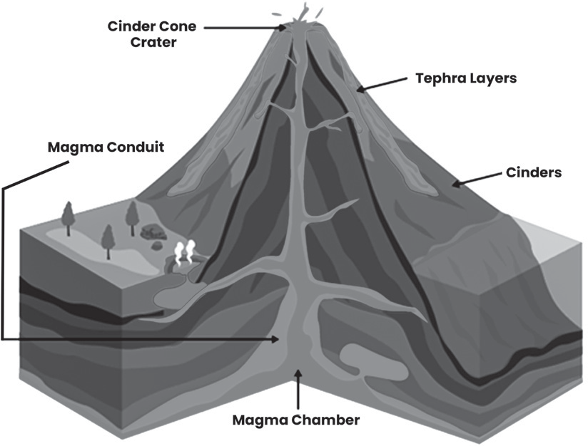
Extrusive Volcanic Landforms
Cinder Cones
• Cinder cones are small, steep-sided volcanoes formed from the accumulation of volcanic debris, including lava and pyroclastic materials. These materials are ejected from a central vent during eruptions and pile up around the vent due to gravity.
• Cinder cones typically have steep, straight sides and a crater at the summit where the volcanic activity occurs.
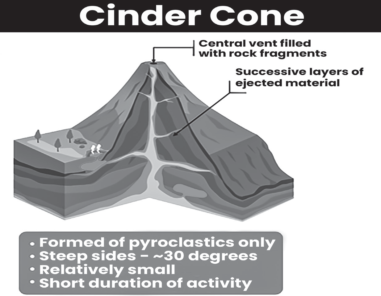
(Fig-Cinder Cone Volcanoes)
Conical Vent
• A conical vent is a narrow, cylindrical opening in a composite volcano through which magma erupts during explosive volcanic activity. These vents are typically found in composite-type volcanoes, also known as stratovolcanoes, which are characterized by alternating layers of lava and pyroclastic materials.
• When pressure builds up within the volcano, magma is forced through the conical vent, leading to explosive eruptions that can eject ash, rocks and other volcanic debris.
Fissure Vent
• A fissure vent is a narrow, linear opening through which magma erupts from a volcano without any explosive activity. Unlike conical vents, fissure vents are characterized by a straight or elongated shape rather than a conical structure. These vents are common in shield- type volcanoes, which are characterized by gentle slopes and built-up layers of basaltic lava flows.
• Shield volcanoes, such as Mauna Loa, form when basaltic lava erupts from fissure vents and accumulates to create a large, broad mountain with a shield-like shape.
Composite-type Volcanic Landforms
• Composite-type volcanic landforms, also known as stratovolcanoes, are characterized by their conical shape and layered composition, which includes alternating layers of pyroclastic materials and lava flows. These volcanoes form when eruptions eject a combination of lava, ash and other volcanic debris. The lava associated with composite volcanoes is typically andesitic in composition, which means it contains a mixture of minerals and has intermediate viscosity.
• Examples of composite-type volcanic landforms include Mount Fuji in Japan and Mount Vesuvius in Italy. These volcanoes are often associated with explosive eruptions due to the buildup of pressure from the interaction between magma and volatile gases within the volcanic conduit.
Caldera
• A caldera is a large, basin-shaped depression formed when a volcanic eruption expels magma from beneath the Earth’s surface, causing the overlying rock to collapse into the emptied magma chamber. These depressions can vary greatly in size and shape, depending on the scale of the eruption and the geologic conditions of the area.
• Prominent examples of calderas include the Yellowstone Caldera in Wyoming, the Long Valley Caldera in eastern California and the Valles Caldera in New Mexico. These calderas are often associated with volcanic hotspots and can be hundreds of square kilometers in area.
• Over time, water from rainfall or snowmelt can accumulate within the caldera, forming a caldera lake. These lakes are often deep and can be surrounded by steep cliffs, creating a dramatic landscape that reflects the caldera’s volcanic origins.
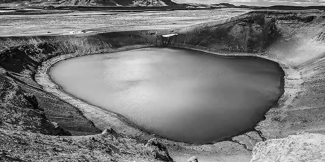
(Fig-Caldera Lake)
Crater
• A crater is a bowl-shaped depression at the summit of a volcano, typically formed by the explosive ejection of volcanic material during an eruption. It can also refer to the vent through which magma flows out during an eruption. Craters can vary in size and shape depending on the scale and type of eruption.
• When a volcano is inactive, the crater may appear as a bowl-shaped depression at the summit of the volcano. Over time, rainwater or snowmelt can accumulate within the crater, forming a crater lake.
• Lake Toba, located in Indonesia, is the largest crater lake in the world. In India, Lonar Lake in Maharashtra is an example of a crater lake.
Volcanic Domes
• Volcanic domes are geological formations that result from the extrusion of highly viscous lava, typically andesitic or rhyolitic in composition. Unlike lava flows that spread out over the surrounding terrain, volcanic domes pile up over the vent from which they erupt, forming a steep- sided mound or dome-shaped structure.
• Due to the high viscosity of the lava, it does not flow very far from the vent before solidifying, resulting in the accumulation of lava near the vent and the gradual growth of the dome over time.
Resurgent Domes
• Resurgent domes are geological features that form within calderas following the collapse of the volcanic summit. When a caldera is formed due to the collapse of the surface above a magma chamber during a volcanic eruption, the magma chamber may become reactivated and re-injected with magma from below. This injection of magma causes certain areas within the caldera to uplift, forming domelike structures known as resurgent domes.
These domes represent the resurgence of volcanic activity and uplift within the caldera region.
Flood Basalt
• Flood basalts are extensive volcanic eruptions characterized by the rapid outpouring of large volumes of basaltic magma from long fissures or cracks in the Earth’s crust known as fissure vents. This magma spreads out in vast sheets over the surrounding landscape, covering large areas with layers of basaltic rock.
• Over time, the accumulation of successive lava flows forms extensive plateaus or basalt plateaus. Flood basalts are associated with continental rifting and hotspot activity and they have played a significant role in shaping the Earth’s surface over geological timescales.
Geothermal Features of Volcanism Geysers, Fumaroles and Hot Springs
• Geothermal features occur in areas with active or inactive volcanoes. Underground magma heats groundwater, producing steam and hot water. This hot water rises to the surface through cracks in the ground, forming features like geysers, fumaroles, hot springs and mud pits.
• Geothermal energy has significant benefits. It generates heat and electricity used to power cities in countries like Iceland, New Zealand, Italy and Northern California. Additionally, geothermal waters may contain valuable minerals like sulfur, gold, silver and mercury, which can be extracted and utilized.
Hot springs are heated by geothermal energy, which comes from the Earth’s interior. In volcanic regions, water can be heated by rocks that are superheated by magma. Hot springs in active volcanic zones may produce water that is extremely hot, posing a danger to anyone who immerses themselves in it. Even in non-volcanic areas, the temperature of rocks beneath the Earth’s surface increases with depth, a phenomenon known as the Geothermal Gradient. If water seeps deep enough into the Earth’s crust, it can encounter these hot rocks and circulate back to the surface, forming hot springs.
• Geysers are famous geothermal features, each with its unique characteristics due to its complex internal structure. Typically, geysers need large amounts of groundwater to fill underground cavities in volcanic regions. The water in these deep underground spaces is heated by nearby magma. Suddenly, some of the water turns into steam and rapidly expands. This causes the water column above to be forcefully ejected from the vent in an explosion of hot water and steam. This process can occur regularly over time.
An example of a famous geyser is Old Faithful in Yellowstone National Park, which has erupted approximately once every 65 minutes for hundreds of years.
• Fumaroles are another type of geothermal feature that forms when volcanic gases interact with groundwater. They occur in areas where a magma conduit passes through the water table underground. The heat from the magma turns water into steam, which rises to the surface along with volcanic gases like hydrogen sulfide.
This steam and gas mixture is released through vents and fissures in the ground.
Fumaroles can be very hazardous due to the chemicals they emit and the surrounding rocks may be colored by associated chemical reactions.
Areas with fumarole features are sometimes called “dying volcanoes” because they often occur near the end stages of volcanic activity, when the magma deep underground solidifies and cools.
Mudpots are surface features formed when small amounts of geothermal water mix with mud and clay. The water contains acid and bacteria that dissolve the surrounding rock, creating thick pools of bubbling mud.
Global distribution of Earthquakes and Volcanoes
Earthquakes and volcanic eruptions affect people globally and are caused by the movement of tectonic plates. Tectonic hazards can cause destruction to buildings, infrastructure and result in fatalities. The Earth’s surface comprises two types of crust.
• Oceanic crust: Found beneath the oceans, it is denser than continental crust and can be pushed beneath another plate (subducted).
• Continental crust: Located under land masses or continents, it is generally older than oceanic crust and is less frequently destroyed.
Earthquakes can occur along all types of plate margins, while volcanoes are typically found at constructive and destructive plate margins. Earthquakes can be triggered by volcanic explosions or sudden movements along fault lines. They are classified into two types: volcanic and tectonic.
Explosive gases rising from beneath the Earth’s surface exert great pressure on the crust, causing intense shaking, especially near volcanoes. Although the affected area is small, the intensity of the tremors can be high. When these gases try to escape through weak spots in the crust with violent explosions, it disrupts the equilibrium of the crust, leading to severe tremors.
These earthquakes serve as indicators of magmatic activity and can signal an impending volcanic eruption. The most significant earthquakes often occur along faults, which are boundaries between tectonic plates where one plate moves over or under another. These faults often form interconnected networks, with smaller branches stemming from main fault lines.
• One of the most well-known examples of this interconnected fault system is the San Andreas Fault in western California, North America. This fault line connects the Pacific Plate and the North American Plate.
Deep intraplate earthquakes, which occur at depths greater than 300 kilometers, are typically caused by normal faulting. Unlike shallower earthquakes, deep intraplate earthquakes usually have very few aftershocks.

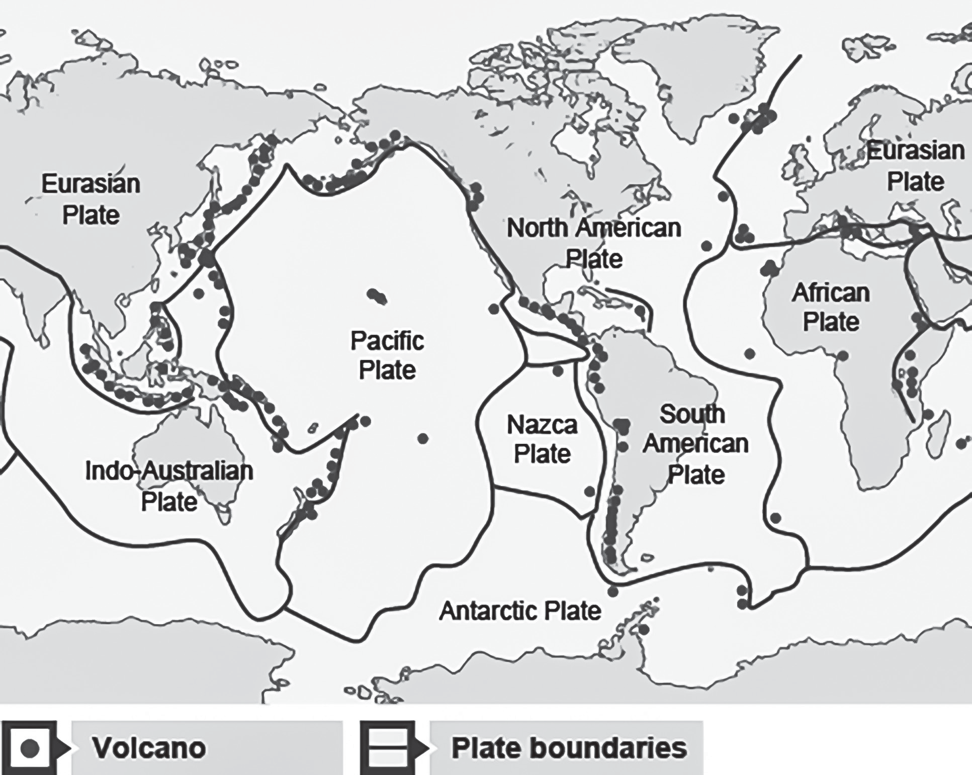
(Fig-World map showing tectonic plate boundaries and earthquake activity)
Ring of Fire
The “Ring of Fire” is a collection of volcanoes situated along the boundary of the Pacific Plate. It’s the most significant area of volcanic activity globally, encircling much of the Pacific Ocean. This line of volcanoes, also called the Ring of Fire or Circum-Pacific Belt, forms a continuous circle around most of the Pacific Ocean
There are five main types of volcanic belts: volcanic ridges, volcanic arcs, volcanic chains, volcanic clusters and volcanic lines.
• Volcanic ridges, like the Mid-Atlantic Ridge, East-Pacific Rise, and Carlsberg Ridge have concentrated volcanic activity along them.
• Arc volcanism occurs in regions like the Aleutian Islands, Kamchatka, Japan, and the Philippines and may indicate early stages of subduction zones. Examples of volcanoes in this belt include Cotopaxi, Katmai, and Fujiyama.
• The Ring of Fire is a region with many volcanoes caused by hot spots deep within the Earth’s mantle. Magma from these hot spots often erupts through cracks in the crust, forming volcanoes such as Mount Fuji in Japan, and the Aleutian Islands in the US.
• Volcanic clusters are found both in oceans and on continents, including the Galapagos, Canary Islands and East African Rift Valley.
• Extinct volcanoes and seamounts form volcanic lines, such as the Hawaiian-Emperor Seamount chain and the Austral-Marshall-Gilbert chain.
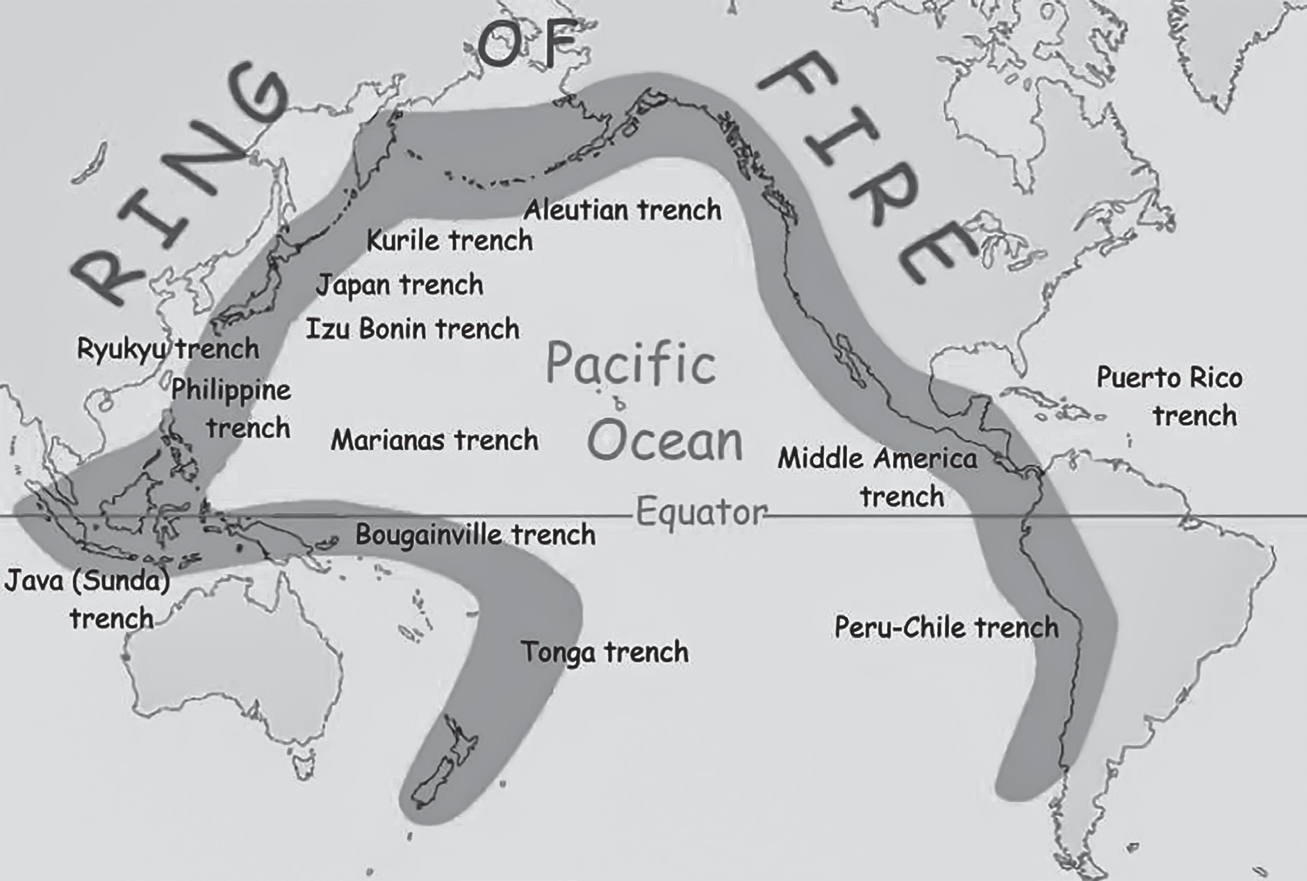
(Fig- Pacific ring of fire)
(Fig- Volcanism around plate boundaries)
Earthquake
Earthquake is the passage of vibrations that occur in the Earth’s interior due to the sudden disturbance or movement of rocks through the Earth’s crust. According to Strahler and Strahler, an Earthquake is a motion of the ground surface, ranging from a faint tremor to a wild motion capable of shaking buildings apart and causing gaping cracks to open up in the ground. It is a form of energy of wave motion transmitted through the surface layer of the Earth in widening circles from a particular point.
This point is called focus which is the source for releasing the sudden energy.
An earthquake is defined as the passage of vibrations through the Earth’s interior. These vibrations range from faint tremors to intense motions capable of causing significant damage, such as shaking buildings and opening cracks in the ground.
• Nature of Earthquake Motion: Earthquakes are described as a form of energy or wave motion that propagates through the Earth’s surface. This motion is transmitted in widening circles from a specific point, known as the focus or hypocenter, which serves as the source of the sudden release of energy.
• Focus of Earthquakes: The focus is the point within the Earth where the seismic energy originates. It is the location where the rocks rupture and release stored energy, leading to the generation of seismic waves that propagate outward through the Earth’s layers.
Causes of Earthquakes: Earthquakes can result from two main causes: Volcanic Activity and Tectonic Activity.
Some of the most significant earthquakes occur in regions near oceanic trenches and volcanic arcs, particularly in the Circum-Pacific Zone. Earthquakes in Japan, Alaska, and Chile, are associated with the movement of tectonic plates along plate boundaries.
Types of Earthquakes
• Volcanic Earthquakes: These earthquakes are directly related to volcanic activity and occur due to the movement of magma or other fluids within a volcano, leading to the collapse of surrounding rocks.
• Tectonic Earthquakes: These earthquakes result from the movement of rocks along fault lines due to stress buildup in the Earth’s crust. When the stress exceeds the strength of the rocks, sudden movement occurs, causing an earthquake.
Earthquakes start deep below the Earth’s surface, typically several kilometers down. To understand them, we use two terms: focus and epicenter.
• Focus or Hypocenter: This is where the earthquake actually starts, deep within the Earth’s crust. It’s where the rocks suddenly break, causing the shaking we feel.
• Epicenter: This is the point on the Earth’s surface directly above the focus. It’s where the earthquake’s effects are most strongly felt.
• Focal Depth: This is how deep the focus is from the epicenter. It’s an important factor in determining how much damage an earthquake might cause.
• Seismic Waves: When an earthquake happens, it sends out seismic waves, similar to ripples spreading out from a rock thrown into a lake. These waves travel through the Earth and are detected by instruments called seismographs.
• Types of Waves: There are two main types of waves generated during an earthquake: body waves and surface waves. Body waves travel through the Earth’s interior, while surface waves travel along the Earth’s surface. Both types of waves gradually decrease in strength as they move away from the earthquake’s focus.
By studying these seismic waves and measuring their arrival times at different locations, scientists can determine the location and characteristics of an earthquake.
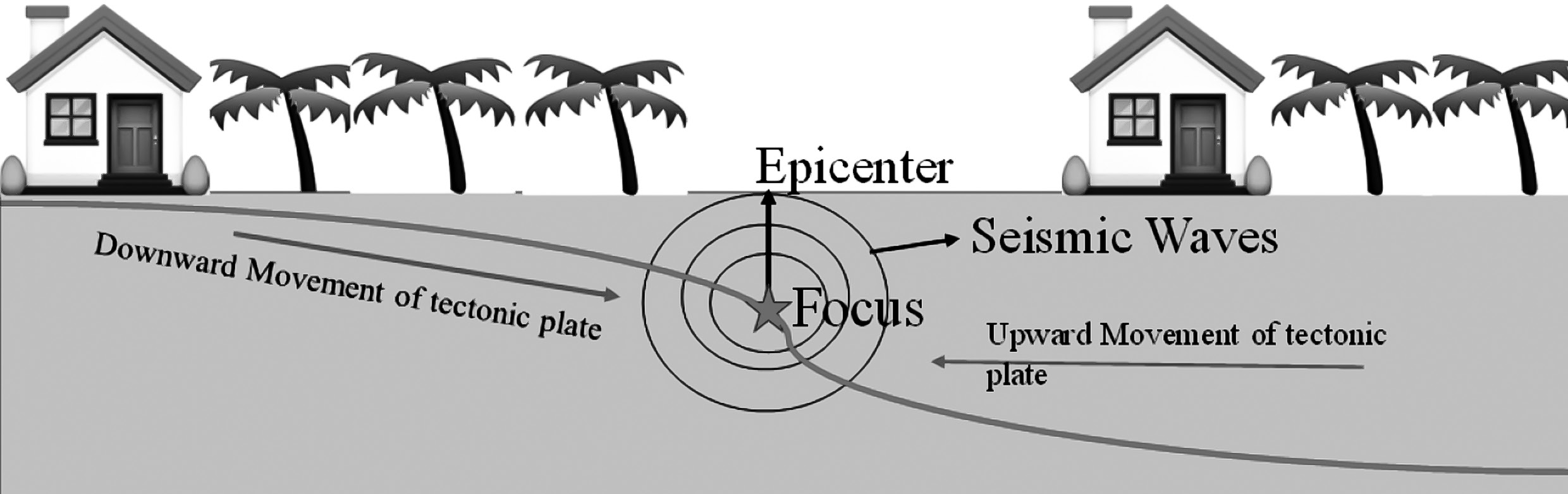
(Fig- Focus and epicenter of the earthquake)
Note: Earthquakes don’t just happen at plate boundaries where plates collide. They can also occur at transform boundaries, where plates slide past each other horizontally. One well-known example is the San Andreas Fault in California, where the Pacific Plate and the North American Plate meet. Along these transform faults, we often see moderate to strong earthquakes.
• Another type of boundary where earthquakes occur is at spreading boundaries, which are found along mid-oceanic ridges where new crust is forming as plates move apart. This includes areas like the mid-Atlantic ridge and the African rift system. Here, earthquakes tend to be shallow.
• Earthquakes can also happen in other places, away from plate boundaries. For example, in the Mediterranean region and across parts of Europe, Asia Minor, the Himalayas, Tibet, and China, there’s a belt known for seismic activity. These earthquakes are related to the movement of the Earth’s crust, even though they’re not right at plate boundaries.
Magnitude and intensity of the earthquake
When an earthquake happens, it releases a certain amount of energy at its source point. To measure how big and destructive an earthquake is, we use a scale called the Richter Scale, named after Charles F. Richter, who created it in 1935.
•Magnitude: The Richter Scale measures the magnitude of an earthquake, which tells us how much energy it releases. This magnitude is based on the amplitude of seismic waves—the stronger the earthquake, the stronger the vibrations it causes.
• Logarithmic Scale: The Richter Scale uses a logarithmic scale, which means that each whole number increase in magnitude represents a tenfold increase in the amplitude of ground motion. For example, a magnitude 6.0 earthquake causes shaking ten times stronger than a magnitude 5.0 earthquake.
• To understand how strongly an earthquake affects different areas, a scale called the Modified Mercalli Scale was developed. This scale was first created by the Italian seismologist Mercalli in 1902 and later updated by Harry Wood and Frank Newmann in 1931.
• Modified Mercalli Scale: This scale measures the intensity of shaking felt during an earthquake, rather than the magnitude of the earthquake itself. It consists of 12 increasing levels of intensity, represented by Roman numerals I to XII.
• Range of Intensities: Each level on the Modified Mercalli Scale describes the range of effects experienced, from barely noticeable shaking (I) to widespread catastrophic destruction (XII).
• So, when you hear about an earthquake’s intensity on the Modified Mercalli Scale, it gives you an idea of how strongly it was felt and the extent of damage it caused in different areas.
Effects of Earthquakes
Earthquakes can lead to various consequences such as ground shaking, soil liquefaction, landslides, fissures, avalanches, fires and tsunamis. The primary effects of earthquakes include ground shaking, ground rupture, landslides, tsunamis and liquefaction. Among these, fires are often the most significant secondary effect of earthquakes.
Earthquakes can happen suddenly and without warning. They occur when there’s movement between tectonic plates along a fault line in the Earth’s crust, resulting in violent shaking of the ground.
The extent of damage caused by an earthquake depends on several factors
• Magnitude: The strength of the earthquake, measured on scales like the Richter Scale, determines how powerful it is.
• Intensity and Duration: How strong the shaking is and how long it lasts also affect the damage.
• Local Geology: The type of rocks and soil in the area can influence how the ground responds to shaking.
• Time of Day: The time when the earthquake occurs can affect how many people are affected and how quickly emergency responders can react.
• Building Design and Materials: Structures built to withstand earthquakes are less likely to suffer severe damage.
• Risk Management Measures: Precautions taken by communities, such as earthquake drills and building codes can reduce the impact of earthquakes.
A powerful earthquake struck southeastern Turkey near the Syrian border on February 7, 2023. The earthquake resulted in the tragic loss of approximately 2,000 lives, with around 1,121 people losing their lives in Turkey according to the country’s disaster agency, and approximately 783 people losing their lives in Syria.
A few impacts can be analysed as
• When an earthquake happens, the ground shakes. This shaking is caused by seismic waves traveling through the ground. It can vary from gentle in small earthquakes to very strong in large ones.
• For example, during the Alaskan earthquake on March 27, 1964, the ground shook strongly for as long as 7 minutes! This shaking can cause buildings to be damaged or destroyed, make it difficult for people and animals to stand or move and even toss objects around.
•Ground rupture is when the movement of an earthquake along a fault breaks through the Earth’s surface. While it doesn’t happen often, there have been instances of ground rupture in California.
• For example, during the 1906 earthquake, fences near Pt. Reyes were shifted by as much as 7 meters.
• Similarly, in the Owens Valley earthquake in 1872, the ground broke along a fault, forming a fault scarp as high as 8 meters near Lone Pine.
• Ground rupture can cause significant problems for humans by damaging or destroying infrastructure such as pipelines, tunnels, aqueducts, railway lines, roads and airport runways that cross the area affected by the rupture.
• Earthquakes can trigger landslides in two main ways: directly by rupturing slopes or by shaking already unstable slopes. These landslides can be highly destructive, destroying buildings, blocking roads and railway lines and even sweeping hilltop homes away as they tumble downhill.
• In some cases, landslides can also dam rivers, leading to flooding, as seen in the 1959 Hebgen Lake earthquake in Montana.
• Liquefaction and subsidence are significant effects of earthquakes, especially in loose ground. Liquefaction occurs when sediment grains float in groundwater, causing the soil to lose its solidity. Subsidence can then happen as the soil settles back down. Sand blows, or sand volcanoes, occur when pressurized jets of groundwater break through the surface, spraying mud and sand over a wide area.
• These effects pose serious dangers to buildings, roads, railways, airport runways and gas lines. In some cases, buildings have even tipped over or sunk partially into liquefied soils, as seen in the 1964 Niigata earthquake in Japan. Underground gas tanks and septic tanks have been known to float to the surface through liquefied soils.
• Overall, liquefaction and its associated effects caused over $20 billion in damage during the 1995 Kobe earthquake in Japan. Similar levels of damage are possible in US port facilities during a large earthquake.
• Fires are a major problem after earthquakes. Ground rupture and liquefaction can damage natural gas and water mains, leading to fires and making it difficult to put them out. For instance, during the 1994 Northridge earthquake, broken water mains were pouring water down streets while nearby ruptured gas mains were causing fires. Shaking can also start fires by knocking down power lines, spilling flammable liquids and tossing hot coals.
In some historical earthquakes, fires have caused significant casualties. For example, in the 1923 Kanto earthquake in Japan, nearly 100,000 people died, with over 70,000 of those deaths attributed to fires that spread after the earthquake. Similarly, much of the damage in San Francisco from the 1906 earthquake was due to subsequent fires.
Tsunami
Tsunamis are giant waves that can cause massive destruction along coastlines. They are typically triggered by sudden underwater landslides, slumping on the seafloor, or earthquakes that cause faulting of the seafloor. Tsunami is a Japanese word meaning “harbour wave.”
• One of the most tragic tsunamis in history occurred on December 26, 2004, in the Indian Ocean. It was generated by a massive earthquake with a magnitude of 9.4 in the Sumatra region of Indonesia. This tsunami claimed the lives of nearly 230,000 people, including significant casualties in Indonesia, Sri Lanka, India and Thailand.
• Tsunamis can travel across the ocean at speeds of 400 to 500 kilometers per hour, and when they reach the coast, they can create waves as high as 40 meters.
• Even though tsunami waves are rare, they can cause extensive destruction and erosion along the coastline.
Here are the important characteristics of tsunami waves
• Tsunamis act as shallow-water waves due to their long wavelengths.
• Shallow-water waves occur when the ratio of water depth to wavelength becomes very small.
• The speed of a shallow-water wave depends on the square root of gravity’s acceleration multiplied by water depth.
• Tsunamis, with their large wavelengths, lose minimal energy as they travel.
• Due to their large wavelengths, tsunamis can travel at high speeds across oceans with limited energy loss.
• When tsunamis reach the shore, they may appear as rapidly rising or falling tides, breaking waves, or a bore. Various coastal features modify the tsunami’s behavior.
• Tsunamis can reach significant heights above sea level onshore, known as runup heights. In rare cases, such as the 1958 Lituya Bay tsunami in Alaska, waves reached exceptional heights, up to 1722 feet (525 meters).
Causes of tsunami waves can be summarised as
• Underwater earthquakes.
• Underwater landslides
• Underwater volcanic eruptions
• Nuclear device detonations under the sea
• Glacier carvings
• Meteorite impacts
A tsunami is NOT
• A tidal wave: Tides are caused by gravitational forces from celestial bodies like the moon, sun and planets. They are unrelated to tsunamis.
• A seismic sea wave: While tsunamis can be generated by seismic activity like earthquakes, the term “seismic” implies an earthquake-related mechanism. However, tsunamis can also be caused by non-seismic events like landslides or meteorite impacts.
• A wind-generated wave (storm wave): Wind generates waves on the surface of the water, whereas tsunamis disturb the entire water column from the surface to the seabed. Wind-generated waves have shorter wavelengths and higher amplitudes compared to tsunami waves in the open ocean.
Tsunami effects include
• Tsunamis can manifest as a falling or rising tide, waves or a bore.
• Tsunamis can persist for several hours.
• A tsunami comprises multiple wave trains that follow one another.
• A sequence of high-water levels is interspersed with low water levels.
Signs preceding a tsunami include
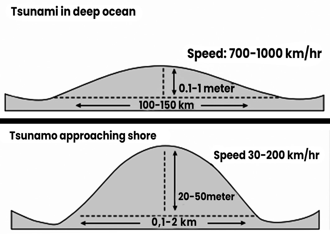
(Fig- Tsunami waves at deep sea and at coast)
• Tsunami warning centers worldwide monitor underwater earthquakes capable of generating large waves, aiming to alert vulnerable coastal areas.
• Seismologists can predict the arrival time of a tsunami at a specific coast with accuracy.
• A tsunami wave consists of a crest and a trough. When the trough reaches the shore, there is a dramatic receding of the shoreline, exposing normally submerged areas of the beach.
• The receding shoreline, known as drawback can extend hundreds of meters inland. While it may pique curiosity, it serves as a warning sign.
• The severity of the impending tsunami waves correlates with the extent of the shoreline withdrawal.
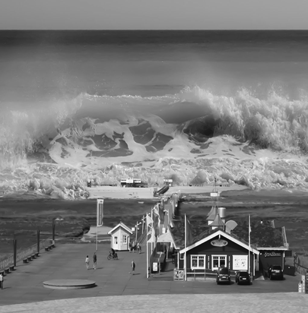
Indian Ocean Tsunami: 2004
The December 26, 2004 Sumatra-Andaman earthquake, with a magnitude of 9.1, occurred along a tectonic subduction zone. In this zone, the India Plate, which is an oceanic plate, is being forced beneath the Burma micro-plate, a part of the larger Sunda plate.
This interaction between the India Plate and the Burma micro-plate results in the formation of a large fault known as an interplate thrust or megathrust. This fault is situated beneath the southwestern part of Sumatra and the Andaman Islands. The point where this interplate thrust intersects the seafloor is indicated by the Sunda trench, which extends in an arc from Burma in the north to Java in the south.
The map, sourced from the USGS Earthquake Hazards Program, illustrates several key features
• The interplate thrust where it intersects the seafloor along the Sunda trench.
• The epicenter of the December 26, 2004 mainshock.
• Major strike-slip faults within the overriding plate of the subduction zone.
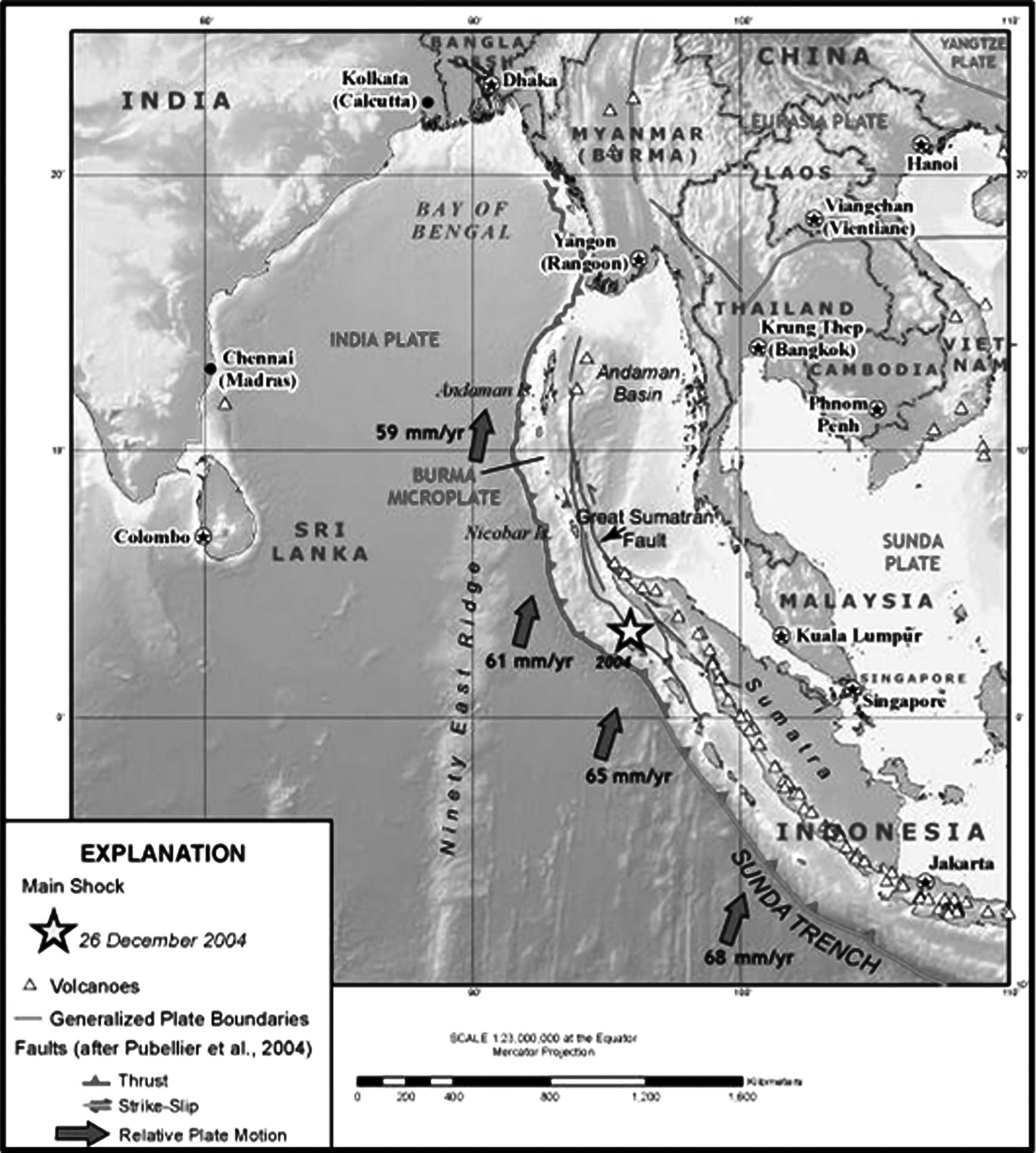
The direction of convergence of the India Plate relative to the Sunda plate (thick arrows on map) is oriented oblique to the orientation of the interplate thrust (i.e., trench axis). For oblique subduction zones such as this, movement between the two plates can be accommodated one of two ways as shown in the block diagram (Michael, 1990). As described in a classic paper by Fitch (1972), the Sumatra subduction zone is characterized by decoupled faulting, as in as shown in diagram (b). In this case, nearly pure thrust faulting occurs along the interplate thrust and strike-slip faulting occurs in the overriding plate, most notably along the Great Sumatran fault. An example of oblique faulting, as in as shown in diagram (a). occurs in the northern Puerto Rico subduction zone.

(Fig-Types of faulting).
Tsunami Warning System
Indian Tsunami Early Warning Centre (ITEWC)
• The Indian Tsunami Early Warning Centre (ITEWC), situated at the Indian National Centre for Ocean Information Sciences (INCOIS) in Hyderabad, operates under the Ministry of Earth Sciences.
• It serves as the primary authority responsible for issuing tsunami advisories for India.
• ITEWC is designated as an approved Tsunami Service Provider within the Indian Ocean Tsunami Warning & Mitigation System (IOTWMS), which is a crucial component of the Global Tsunami Warning and Mitigation System.
• This global system is coordinated by the Intergovernmental Oceanographic Commission (IOC) of UNESCO.
Tsunami Programme of IOC-UNESCO
• The Tsunami Programme of the Intergovernmental Oceanographic Commission (IOC) of UNESCO plays a vital role in global tsunami risk reduction efforts. Through various activities such as regional meetings, capacity building initiatives and support for national and regional projects, the programme aims to enhance preparedness and response capabilities.
• To address specific regional needs, the Tsunami Programme has established four Intergovernmental Coordination Groups (ICGs) corresponding to different regions: the Pacific Ocean, Caribbean Sea, Indian Ocean and Northeast Atlantic Ocean & Mediterranean Sea.
• In addition, the IOC Assembly established a Working Group on Tsunamis and Other Hazards Related to Sea- Level Warning and Mitigation Systems (TOWS-WG) during its 24th Session. This working group provides advice to the IOC governing bodies on the coordinated development of warning and mitigation systems for tsunamis and other sea-level-related hazards of common interest to all ICGs.
Tsunami Warning Service Framework
The Tsunami Warning Service Framework outlines the key components of a comprehensive tsunami early warning and mitigation system. It involves various stages, including risk assessment and reduction, detection, warning dissemination and awareness and response. Here’s what each component entails:
• Risk Assessment & Reduction: This involves identifying and evaluating tsunami risks in coastal areas, implementing measures to reduce vulnerabilities and raising awareness among communities about tsunami hazards.
• Detection: Rapid detection of large earthquakes is crucial for initiating tsunami warnings. Real-time seismic networks are used to detect earthquakes, while sea-level networks monitor tsunami waves.
• Warning & Dissemination: Tsunami Service Providers (TSPs) operate around the clock to assess the potential for tsunamis and monitor tsunami waves. They distribute warning products to National Tsunami Warning Centres (NTWCs) or Tsunami Warning Focal Points (TWFPs) within the affected region.
• Awareness & Response: Mandated national organizations within each sovereign nation are responsible for alerting citizens and communities about tsunami threats. They may rely on their own analysis or information received from TSPs to issue alerts and coordinate emergency responses.
The coordination of regional tsunami warning systems by IOC-UNESCO ensures a cohesive “system of systems” approach to tsunami warning and mitigation on a global scale.
Area of Service
• The Area of Service for Tsunami Service Providers within a regional tsunami warning system is determined by the respective Intergovernmental Coordination Groups (ICGs). These groups ensure coverage of vulnerable coastal regions in participating Member States while maintaining high standards of service and interoperability.
• Coordination at the global level is facilitated by the Tsunamis and Other Hazards Related to Sea-Level Warning and Mitigation Systems Working Group (TOWS- WG) to ensure comprehensive coverage and effective cooperation among participating nations.
Tsunami Service Providers
The approved Tsunami Service Providers that are currently operating under the IOC-UNESCO framework are given below:
• Pacific Tsunami Warning and Mitigation System (PTWS)
• Caribbean and Adjacent Regions (CARIBE EWS)
• Indian Ocean Tsunami Warning and Mitigation System (IOTWMS)
• Northeast Atlantic, Mediterranean and Connected Seas (NEAMTWS)
Volcanism in India
Within the geographical boundaries of India, there are eight recognized volcanoes. Among these, Barren Island stands out as the only active volcano, signifying that it has had recent eruptions, the latest of which occurred in 2017. This makes Barren Island unique in the region stretching from Sumatra to Myanmar, as it is the sole volcano exhibiting active volcanic behaviors within this range.
• The island, set amidst the waters of the Andaman Sea, attracts tourists, not just for its geological significance as an active volcano, but also for the natural beauty and uniqueness of being a volcanic island.
• The other seven volcanoes in India, including any mud volcanoes, are currently considered inactive, meaning they haven’t erupted in recent times and don’t show signs of imminent activity.
• Narcondam, a small volcanic island located in the northern Andaman Sea, is notable for being the easternmost island of India. The island features a peak composed of andesite, a type of volcanic rock, reaching up to 710 meters above sea level, indicating its significant height and volcanic origin. Being part of the Andaman Islands, Narcondam adds to the archipelago’s geographical and ecological diversity.
The possible origin of the island’s name, deriving from the Tamil words “naraka-kundram,” suggests a cultural interpretation of the island as “a pit of Hell,” likely referencing its volcanic nature and the inherent dangers or awe-inspiring characteristics traditionally associated with volcanoes.
• The large Deccan Plateau of the Indian Subcontinent lies between two mountain ranges. It is roughly defined as the peninsular area south of the Narmada River between the Western and Eastern Ghats. It is bordered to the north by the Satpura and Vindhya Mountains. The fact that the Deccan Plateau is mostly made up of basalt, which is an extrusive igneous rock, is proof of its volcanic origins.
• Baratang Island, located within the Andaman Islands chain, is unique in India for housing the country’s only known mud volcanoes. Positioned approximately 150 kilometers north of Port Blair—the capital city of the Andaman and Nicobar Islands—Baratang Island is renowned not just for its mud volcanoes, but also for its natural beauty and diverse landscapes.
These include attractive beaches, intricate mangrove creeks, and captivating limestone caves.
Positive and Negative Effects of Volcanoes
A volcano represents a significant event where the Earth’s surface breaks open, allowing the escape of molten rock (lava), ash, and gases from a magma chamber located beneath the surface. This process is driven by the movement of tectonic plates that make up the Earth’s crust and is influenced by various geophysical and geochemical factors. Volcanic eruptions and the presence of volcanoes can have both beneficial and harmful impacts on our environment and society. These impacts are categorized into two main types:
Negative effects of volcanoes
Positive effects of volcanoes
Negative effects of volcanoes
• Loss of Habitats: Volcanic eruptions can obliterate natural habitats through the intense heat and flow of lava, destroying ecosystems and the living organisms within them. Lahars (volcanic mudflows) and debris flows can bury entire communities under mud and rocks.
• Death to Wildlife: The heat and lava from eruptions, along with toxic gases and ash can kill plants and animals in the surrounding areas.
• Air Pollution: Eruptions release vast quantities of gases and particulates into the atmosphere, including carbon dioxide, sulfur dioxide and ash, contributing to air pollution and affecting air quality.
• Sudden Weather Changes: Volcanic activity can influence weather patterns, causing phenomena like rain, thunder, and lightning, and can even have long-term effects on climate.
• Landslides: The destabilization of land during intense eruptions can trigger landslides, particularly in areas with steep slopes.
• Health Issues: The release of volcanic gases and ash can cause respiratory diseases, lung cancer, eye problems and other health issues in humans and animals.
• Water Pollution: Volcanic ash and materials can contaminate water bodies, rendering them unsafe for consumption or use by humans and animals.
• Additional negative consequences include the potential for forest fires, economic losses due to destruction of property and infrastructure, depletion of the ozone layer through the release of chlorine and bromine from volcanic eruptions, land pollution from acid rain and the triggering of tsunamis and earthquakes as a result of volcanic activity.
Positive effects of volcanoes
• Reduces Heat: Volcanoes can have a cooling effect on the planet. Eruptions send ash and gases into the stratosphere, reflecting sunlight away from the Earth and potentially lowering temperatures. The 1815 eruption of Mount Tambora in Indonesia, which led to “the year without summer,” is an example of how volcanic activity can significantly cool the Earth’s climate temporarily.
• Increases Soil Fertility: The materials released by volcanic eruptions, such as lava and tephra, break down into rich soil over time. This soil is high in nutrients like iron and potassium, making it highly fertile and ideal for agriculture, as seen in regions like Italy and the Deccan Plateau in India.
• Source of Energy: Volcanic areas are potential sources of geothermal energy. The heat from magma close to the Earth’s surface can be used to generate electricity, offering a renewable energy source that can reduce reliance on fossil fuels.
• Increases Infiltration: The loosening of soil due to volcanic vibrations can enhance water infiltration, improving the soil’s ability to absorb water. This can benefit agriculture by increasing the soil’s moisture retention capabilities.
• Volcanic eruptions create landscapes: The physical landscape be it on continents, volcanic islands, and the seafloor is largely due to volcanic eruptions. As lava oozes and spurts from volcanoes, it creates distinct landforms. Eventually, weathering and erosion sculpture particular landforms. Thus, they form mountains, hills, plateaus, plains, depressions, caves, and valleys.
• Creates Landscapes: Volcanic activity is a primary force in shaping the Earth’s landscape, creating mountains, hills, plateaus, and various other landforms. These features contribute to the planet’s geological diversity and offer habitats for numerous ecosystems.
• Precious Minerals: The process of volcanic eruptions can bring deep-seated minerals to the surface, including valuable metals like copper, gold, and diamonds. These minerals are critical to various industries and have significant economic value.