Whatsapp 88106-52225 For Details
Get Free IAS Booklet
Get Free IAS Booklet
CONTINENTAL DRIFT THEORY
The Continental Drift Theory was proposed by Alfred Wegener, a German scientist, in 1915. According to this theory, the Earth’s crust can move horizontally, causing continents to change their positions over time.
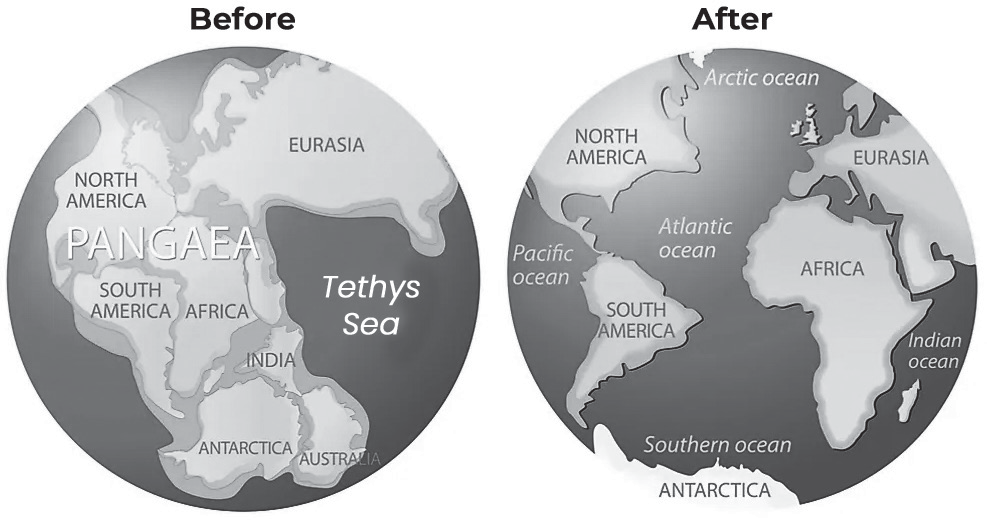
A long time ago, around 200 million years ago, all the land on Earth was stuck together in one huge landmass called Pangaea, which means “all lands” in Greek.
Then, slowly, the landmass began to split apart. It broke into two big pieces: one in the north called Laurasia and one in the south called Gondwanaland (named by another scientist, Eduard Suess).
These two big pieces continued to break apart into the smaller continents we see today. This movement of landmasses is what scientists call “continental drift.”
Forces Responsible for Continental Drift

Fig-Jig-Saw-Fitting
Wegener suggested that continental drift occurred in two directions. Firstly, it moved towards the equator due to a combination of gravity, forces pushing away from the poles (centrifugal forces caused by the Earth’s rotation), and buoyancy. Secondly, it moved westward due to tidal currents caused by the Earth’s rotation (as the Earth spins from west to east, tidal currents move from east to west).
Note: However, later research showed that these explanations alone were not enough to explain continental drift. This finding is seen as a criticism of Wegener’s theory.
Evidences Supporting Continental Drift Theory
• The Matching of Continents (Jig-Saw-Fit)- one piece of evidence for continental drift is that the coastlines of continents like South America and Africa seem to fit together like puzzle pieces. Similarly, when you line up the east coast of Africa with Madagascar and the east coast of India, they also fit together like pieces of a puzzle. This suggests that these continents were once connected or very close together.
• Rocks of Same Age across the Oceans- Scientists have used radiometric dating to compare the ages of rocks on different continents. They found that the mountain ranges in Western Africa have similar aged rocks to those off the coast of Brazil, dating back around 2,000 million years. Similarly, there are similarities between the Caledonian Mountains in Europe and the Appalachian Mountains in North America.
Additionally, they found that marine deposits along the shores of Africa and South America were formed during the Jurassic period, indicating that these continents were once connected and the ocean between them formed later.
• Tillite deposits- Scientists have found a type of sedimentary rock called tillite, which forms from glacial deposits. They discovered similar rocks on six different landmasses in the Southern Hemisphere: Africa, the Falkland Islands, Madagascar, Antarctica, Australia, and India.
These rocks are similar to those found in the Gondwana system of deposits from India. This suggests that these landmasses shared a similar history in ancient times, likely when they were part of a single supercontinent called Gondwana.
• Placer Deposits- Along the coast of Ghana in West Africa, there are deposits of gold known as placer deposits. Surprisingly, there is no nearby source rock where this gold could have originated. However, similar gold- bearing veins are found in Brazil.
When you compare the positions of Ghana and Brazil on a map, it seems like Ghana’s gold deposits could have come from the same source as those in the Brazilian plateau.
• Distribution of Fossils- The same types of fossils and animals can be found on opposite sides of a barrier like a sea. For example, Mesosaurus, a reptile similar to a freshwater crocodile, lived between 286 and 258 million years ago and can be found in both Southern Africa and Eastern South America. This suggests that these areas were once connected or very close together.
Formation of the Himalayas
The Himalayas are a huge mountain range that formed when two big chunks of land, India and Eurasia, crashed into each other about 40 to 50 million years ago. Because both pieces of land are made of similar kinds of rock and are dense, neither one could slide underneath the other.
• Instead, the pressure pushed the land upward, creating the tall and jagged peaks of the Himalayas that we see today.

About 225 million years ago, India was an island near Australia, separated from Asia by a large ocean called the Tethys Sea. When the supercontinent Pangaea started breaking apart around 200 million years ago, India began moving northward. Scientists have figured out this movement by studying the history of the Tethys Sea.
Around 80 million years ago, India was about 6,400 km south of Asia and moving north at a slow rate. When India finally collided with Asia around 40 to 50 million years ago, its northward movement slowed down significantly. This collision marked the start of the rapid rise of the Himalayas.
The Himalayas and the Tibetan Plateau have been rising rapidly for about 50 million years. Mountains like Mt. Everest have reached heights of over 9 km at that time. However, the collision between the Indian and Eurasian plates is still ongoing. The Himalayas are still growing, with peaks rising about 1 cm every year, which amounts to 10 km in a million years.
• But why aren’t the Himalayas even taller? Scientists think that now the Eurasian Plate might be stretching instead of pushing up, and this stretching could cause some areas to sink due to gravity, counteracting the upward growth of the mountains.
Scientists found layers of pink sandstone containing grains of magnetic minerals about 50 kilometers north of Lhasa, the capital of Tibet. These minerals recorded changes in the Earth’s magnetic field over time. The sandstones also contain fossils of plants and animals that lived when the Tethys Sea periodically flooded the area. By studying these fossils, scientists can determine their age and the type of environment they lived in.
• For example, fossils indicate that around 105 million years ago, when Tibet was closer to the equator, the climate was mild and wet. Today, Tibet’s climate is much drier due to its uplift and movement northward over about 2,000 kilometers. Fossils found in these sandstone layers provide clear evidence of climate change in Tibet over the past 100 million years due to plate movements.
Formation of Andes Mountain
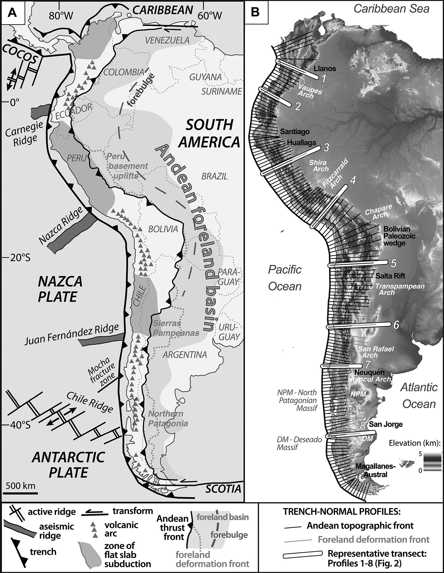
(Fig- Formation of Andes Mountain range)
The Andes mountains were formed because the Nazca plate and the South American plate are crashing into each other. The Nazca plate, which is heavier and denser, is being pushed underneath the South American plate in a process called subduction.
• The South American plate, being lighter, sits on top, but its rocks are pushed upwards, forming fold mountains. Along this collision zone, there are also volcanoes and earthquakes.
• Earthquakes happen when the plates try to move past each other, causing stress to build up. Volcanoes form when magma pushes up through cracks in the Earth’s crust.
• This combination of processes has created a chain of volcanoes and fold mountains, with the tallest peak being Aconcagua at 6,962 meters. The trench marking the boundary between the two plates, known as the Peru-Chile Trench, is incredibly deep, reaching 8,066 meters below sea level.
Formation of Rockies
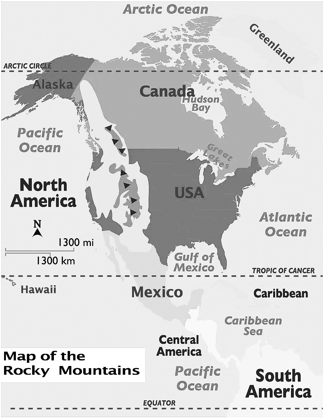
The Rocky Mountains formed during a period of intense pressure on the Earth’s crust, which caused it to fold and push upwards. This process, called compression, led to the formation of thrust faults, where rocks were pushed on top of each other.
The mountains are made up of various types of rocks - igneous, sedimentary, and metamorphic - that were pushed up from below during two major mountain-building events called the Sevier and Laramide orogenies, which occurred between 80 to 55 million years ago.
• The main phase of mountain-building, known as the Laramide orogeny, started around 80 to 50 million years ago and finished about 35 million years ago, shaping the landscape we see today as the Rocky Mountains.
Transform Plate Boundaries
Transform Plate Boundaries are places where two tectonic plates slide past each other. The area where this sliding occurs is called a transform fault. Most transform faults are found under the ocean and connect segments of mid-ocean ridges. Some also link mid-ocean ridges with subduction zones.
• A well-known example is the San Andreas Fault in western North America, which connects a divergent boundary in the Gulf of California with the Cascadia subduction zone.
• Another example is the Alpine Fault in New Zealand, which is a transform boundary on land.
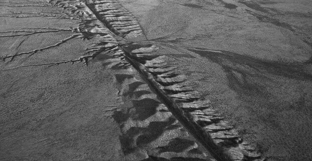
(Fig- Illustration of transform plate boundaries, San Andreas Fault)
(Fig- San Andreas fault of California, USA)

SEAFLOOR SPREADING
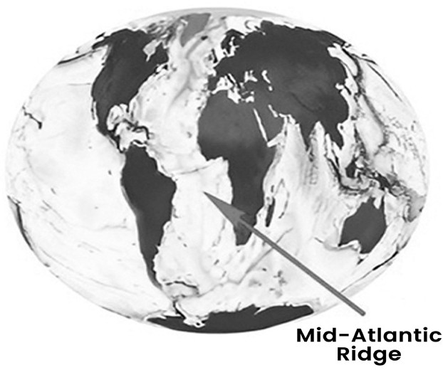
Seafloor spreading is a process where large pieces of the Earth’s crust, called tectonic plates, move apart from each other. This happens mainly along underwater mountain ranges called mid-ocean ridges. One example of a mid-ocean ridge is the
Mid-Atlantic Ridge, which is in the Atlantic Ocean. As the plates move apart, new ocean floor is created in between.
This causes the Atlantic Ocean to gradually widen by a few centimeters each year. To understand seafloor spreading, it is important to know about the convection currents in the Earth’s mantle and how they influence plate movement, as well as paleomagnetism, which is the study of Earth’s magnetic field recorded in rocks.
CONVECTIONAL CURRENT THEORY
Convection is a process where fluids (like liquids or gases) move due to differences in temperature. This movement helps transfer energy from one place to another. Convection currents, also known as convective heat transfer, are responsible for this movement. It’s important to note that solids cannot experience convection currents.
•Arthur Holmes introduced the Convectional Current Theory in the 1930s, which explains how heat moves within the Earth’s mantle. This theory forms the basis of the seafloor spreading theory, which explains how new oceanic crust is formed at mid-ocean ridges due to convection currents in the mantle.
According to this theory, the Earth’s mantle, which lies between 100 to 2900 kilometers below the surface, generates intense heat due to radioactive chemicals. This heat tries to escape, causing convection currents to form in the mantle. These currents move through the semi-liquid layer called the asthenosphere, which lies beneath the solid outer layer called the lithosphere. When these convection currents diverge, they pull apart blocks of the Earth’s crust in opposite directions. This process creates new ocean floors and bodies of water. Examples include the East African Rift Valley lakes and the Mid-Atlantic Ridge.
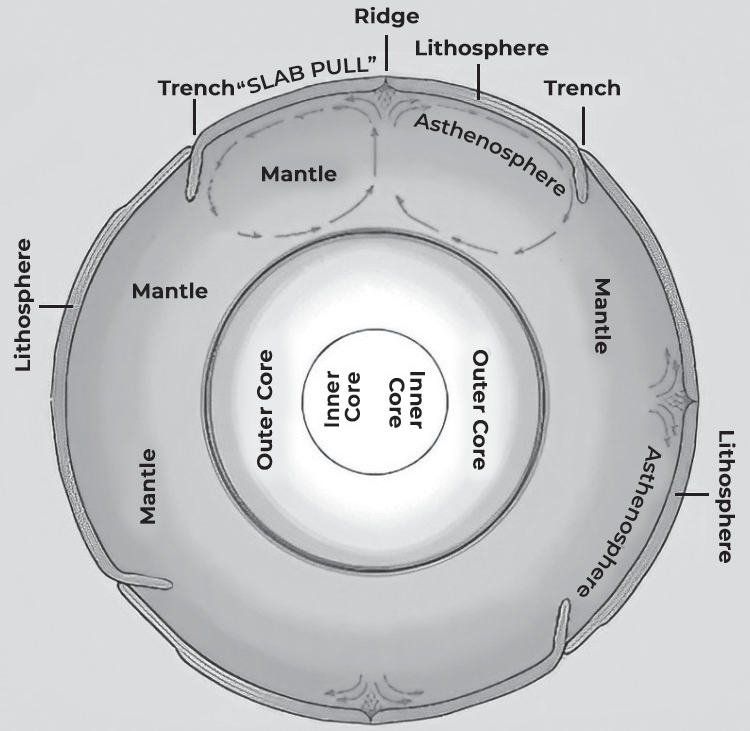
Here are the features of seafloor spreading
•Seafloor spreading helps explain how continents move in the theory of plate tectonics.
•This theory was suggested by Hess in 1961. He proposed that continuous volcanic eruptions at the center of oceanic ridges cause the oceanic crust to crack, and new lava fills in these cracks, pushing the oceanic crust apart. This process spreads the ocean floor.
• Hess noticed that the oceanic crust is younger and spreading one ocean doesn’t make another shrink. He thought that this might mean, the oceanic crust is being destroyed.
• He also believed that the oceanic crust pushed apart at the ridges sinks down into oceanic trenches and gets consumed or destroyed.
PALEOMAGNETISM
Paleomagnetism is the study of Earth’s magnetic field as recorded in rocks. Scientists found that certain minerals, when they form, can align themselves with the Earth’s magnetic field. This discovery, made in the 19th century, has been important in providing evidence for plate tectonics.
It has helped scientists understand changes in Earth’s magnetic field over millions of years, supporting Alfred Wegener’s theory of continental drift, which later evolved into the theory of plate tectonics.
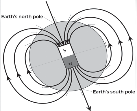
When magma, the molten rock beneath the Earth’s surface, cools and hardens into rock, the minerals within it become locked in place. If the mineral magnetite (Fe3O4) is present, it aligns itself with the Earth’s magnetic field at that time, much like a compass needle points north. This alignment creates a magnetic record in the rock, known as remnant magnetism.
Earth’s magnetic field is created by its North and South Poles, which are aligned with its axis of rotation. Magnetic force flows into the Earth in the Northern Hemisphere and out of the Earth in the Southern Hemisphere. Due to the shape of the magnetic field lines, the angle of the magnetic force varies in different locations. At the North and South Poles, the force is straight down or straight up, making it vertical. Along the equator, the force is horizontal, and in between the poles and the equator, the force is at some angle between vertical and horizontal.
THEORY OF PLATE TECTONICS
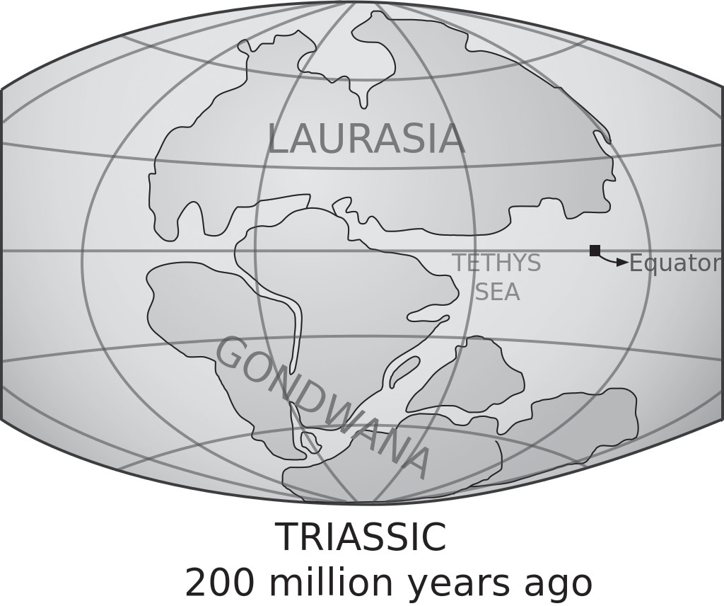
Fig: The super continent Pangea
The Theory of Plate Tectonics expands on Wegener’s Theory of Continental Drift. It’s a theory, that helps explain how geological features are spread across the Earth. Basically, it talks about how the outer layer of the Earth, called the lithosphere, is divided into several large and small pieces called tectonic plates. These plates move around on the Earth’s surface, interacting with each other. Sometimes they collide, move apart, or slide past each other.
These movements can cause different geological events like earthquakes, volcanoes, continents shifting, and the formation of mountains. So, the Theory of Plate Tectonics helps us understand why these things happen and how they’re connected.
In, the Theory of Plate Tectonics, it’s not the continents but the tectonic plates that move. Tectonic plates are like giant puzzle pieces that make up the Earth’s outer layer, called the lithosphere. The lithosphere includes the crust (the outermost layer) and the upper mantle (the layer below the crust). These plates float on a partially liquid layer beneath them called, the asthenosphere. Tectonic plates can move because, the lithosphere is stronger and denser than the rock underneath it.
There are seven major tectonic plates that cover most of the Earth’s surface, including the continents and the Pacific Ocean:
• African Plate
• Antarctic Plate
• Eurasian Plate
• Australian Plate
• North American Plate
• Pacific Plate
• South American Plate
These plates are quite large, typically at least 20 million square kilometers in size. They constantly shift and interact with each other, leading to geological events like earthquakes, volcanoes, and the formation of mountains.
Apart from the seven major tectonic plates, there are also many smaller plates, such as the Juan de Fuca, Nazca, Scotia, Philippine, and Caribbean plates. Some of these smaller plates are actually made up of even smaller plates or sub-plates.
• For example, the Juan de Fuca Plate consists of three separate plates: Gorda, Juan de Fuca, and Explorer. These plates all move in the same general direction, but they move at slightly different speeds.
• The speed at which tectonic plates move varies. Some move very slowly, less than 1 centimeter per year, while others move much faster, over 10 centimeters per year.
• The Pacific Plate is one of the fastest-moving plates, with speeds exceeding 10 centimeters per year in some areas. Other fast-moving plates include the Australian and Nazca Plates. On the other hand, the North American Plate is one of the slowest, moving at an average speed of around 1 centimeter per year in the south and up to almost 4 centimeters per year in the north.
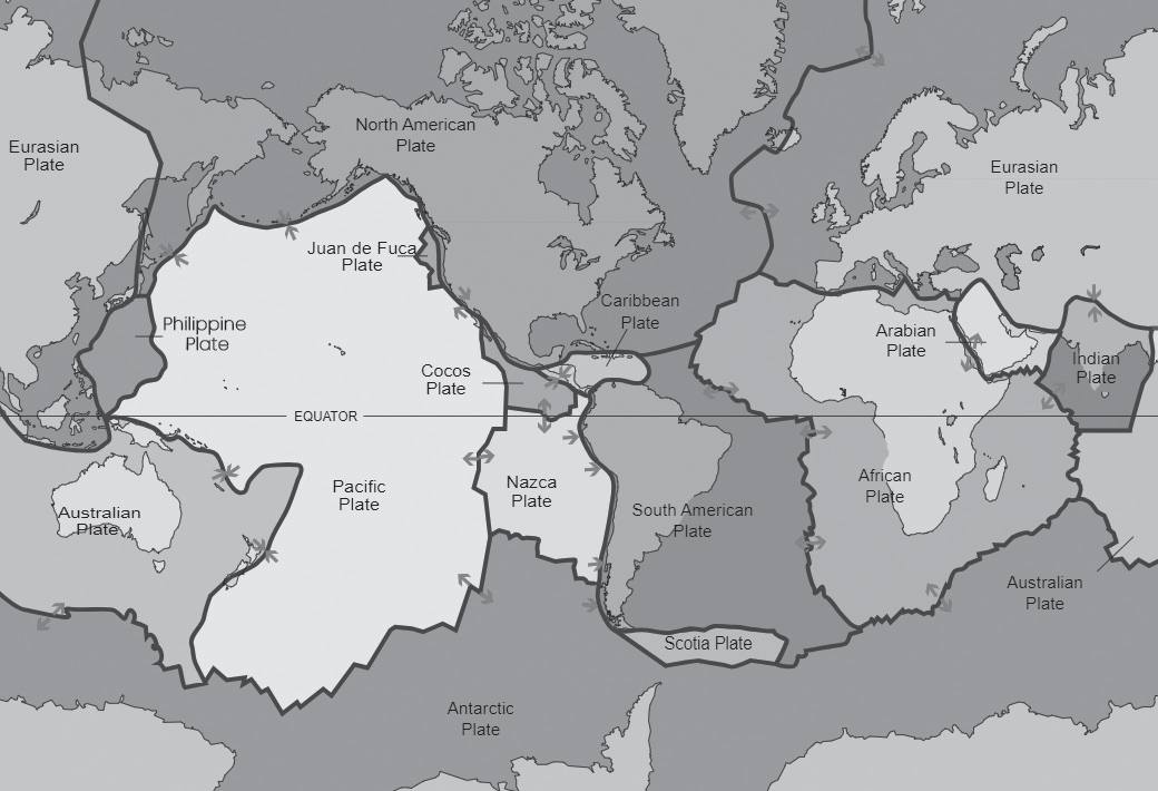
(Fig: 7 major plates and few minor plates of the world)
Types of Plate Tectonic Boundaries
The boundaries between tectonic plates come in three types:
• Divergent boundaries: This is where plates are moving apart from each other.
• Convergent boundaries: Here, plates are moving toward each other and may collide.
• Transform boundaries: At these boundaries, plates slide past each other sideways.
It’s important to understand that there are no empty spaces between these plates. They’re made up of the Earth’s crust and the lithospheric part of the mantle.
Scientists believe that these plates move along the boundary between the lithosphere (the rigid outer layer) and the asthenosphere (a semi-fluid layer beneath it). The asthenosphere is partially melted, which makes it weaker and allows the lithospheric plates to slide around.

Divergent Plate Boundaries
When two tectonic plates move away from each other, it’s called a divergent boundary, caused by tensional stress. This movement creates new crust between the plates.
At these boundaries, the Earth’s outer layer, called the lithosphere, gets pulled apart. It breaks along parallel faults that tilt slightly outward. The area between the faults sinks down, forming a central valley called a rift. Magma (liquid rock) rises up to fill the gaps, creating new crust.
This process leads to earthquakes along the faults and the formation of volcanoes where magma reaches the surface. Some famous examples of divergent boundaries are the East Africa Rift in Kenya and Ethiopia, the Rio Grande Rift in New Mexico, and the Mid-Atlantic Ridge.
The Mid-Atlantic Ridge, for instance, is a long mountain range underwater in the Atlantic Ocean. It’s about 65,000 kilometers (40,000 miles) long and slowly grows wider each year as the Atlantic Ocean widens. The rift valley in the Mid-Atlantic Ridge grows at a rate of about 2 to 5 centimeters (0.8 to 2 inches) per year and is about as deep and wide as the Grand Canyon.

(Fig: image of divergent plate boundary)
• Rift valleys, also known as grabens, are formed by the movement of tectonic plates, not erosion.
• Geologists use the term graben mainly to describe valleys on landmasses. These valleys are created when the Earth’s crust pulls apart, causing the land to drop down between parallel faults.
• These valleys can form when either continental or oceanic plates move apart at divergent boundaries.
• They can be found both on land and underwater. Examples include the East African Rift Valley and the Narmada Rift Valley.
• Rift valleys are different from river valleys and glacial valleys because they’re formed by tectonic activity, not erosion processes.
Iceland rift valley
• Iceland is a special place where scientists study the mid-ocean ridges, which are underwater mountain ranges, and tourists can actually walk through a valley formed by one of these ridges. This valley marks the boundary between two tectonic plates: the Eurasian Plate and the North American Plate.
• The Mid-Atlantic Ridge, which is a chain of underwater mountains, runs right down the middle of the Atlantic Ocean. However, parts of it rise above the ocean’s surface on Iceland. This is because Iceland is not only sitting on top of the Mid-Atlantic Ridge but also above a hot spot in the Earth’s mantle.
• Because of this unique combination, visitors to Iceland can walk along the Mid-Atlantic Ridge and experience firsthand the power of tectonic activity shaping the Earth’s surface.
How do tectonic forces create valleys?
• When tectonic forces pull a crustal plate in two different directions, it causes the crust to thin out. This creates parallel faults in the crust as it gets pulled apart. In the middle, a section of the crust drops down, forming what’s called a graben or a rift valley.
• As the tectonic forces keep pulling the crust apart, the rift valley gets bigger and deeper, turning into a basin. The basin keeps dropping down as the rift widens, creating a larger and deeper depression in the Earth’s surface.
Lake Baikal and Lake Tanganyika
Lake Baikal and Lake Tanganyika were, once rift valleys that formed as a result of the Earth’s crust being pulled apart. These rift valleys became so deep that they eventually filled with water, forming lakes.
• Lake Baikal is the deepest lake on Earth and holds the freshest water as compared to any lake worldwide. It’s located in Siberia, on the Baikal Rift Zone.
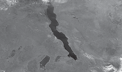
• Lake Tanganyika is the second largest lake and holds the second largest volume of fresh water on Earth. It’s located in Africa, on the western arm of the East African Rift Zone.
• Both of these rift zones are still active, which means the Earth’s crust is still being pulled apart. If this activity continues, the crustal plates they’re located on could eventually split apart, leading to the creation of new plates. Eventually, seawater could flood the rift valleys, turning them into seas, similar to the Red Sea.
Horst and Graben topography
• Horst and Graben, also known as valley and range, are types of landscapes formed when the Earth’s crust is stretched apart, a process called extension. This stretching can make the crust expand up to twice its original size.
• During this stretching, normal faults develop, causing blocks of crust to drop down and form valleys called grabens.
• The end result is a landscape with alternating valleys and ridges. Valleys formed in grabens are often called rift valleys and may show signs of volcanic activity related to the formation of grabens.
• Examples of grabens include the Jordan–Dead Sea depression and Death Valley. On the other hand, typical horsts include the Vosges Mountains in France and the Palestine Plateau.
• In India, examples of grabens are seen in the Narmada and Tapi river valleys, which flow between the rift valleys of Vindhyan, Satpura, and Ajanta.

(Fig- Horst and Graben formation)
Oceanic rift zones
Oceanic rift zones are found deep in ocean basins where two oceanic plates are moving apart from each other. These rift zones weren’t known about until around the middle of the last century.
The discovery of these rift zones helped scientists understand how continental drift, a theory proposed by Alfred Wegener in the early 20th century, could happen on Earth. It also contributed to the development of the Theory of Plate Tectonics. This theory explains how the Earth’s outer shell is divided into plates that move around on the semi-fluid layer beneath them, shaping the Earth’s surface over time.
Convergent Plate Boundaries
When two tectonic plates come together, it’s called a convergent plate boundary, caused by compressional stress. At these boundaries, mountains can form as one or both continental plates are pushed upward.
For example, the Himalayan Mountain range and the Tibetan Plateau formed when the Indian and Eurasian Plates collided. Over millions of years, the plates pushed against each other, resulting in the formation of the Himalayas, which are the highest mountains on Earth. Mount Everest, part of the Himalayas, is the tallest mountain in the world.
A subduction zone is where one tectonic plate is pushed or forced beneath another plate. This process creates underwater trenches, which are the deepest parts of the ocean.
The deepest point in the ocean is Challenger’s Deep, located in the Mariana Trench in the Pacific Ocean. The Mariana Trench is formed where the fast-moving Pacific Plate slides under the slower moving Philippine Plate.
Along convergent plate boundaries, where plates collide, there is often volcanic and seismic activity. The Pacific Ring of Fire is a horseshoe-shaped area in the Pacific Ocean where over 450 volcanoes are located. This region extends about 40,250 kilometers and is known for frequent volcanic eruptions and earthquakes.
Convergent boundaries are places where two tectonic plates are moving towards each other. There are three types of convergent boundaries, based on the type of crust involved
• Oceanic-Continental Convergent Boundary
• Oceanic-Oceanic Convergent Boundary
• Continental-Continental Convergent Boundary
Oceanic-Continental Convergent Boundary
Oceanic-continental convergent boundaries occur when an oceanic plate crashes into a continental plate. Oceanic plates are heavier because they have more dense materials, like iron and magnesium. When they collide with lighter continental plates, they get pushed beneath them in a process called subduction.
As the oceanic plate sinks into the hot layer beneath the Earth’s surface (called the asthenosphere), the intense heat causes trapped materials, like water, to escape from the rocks. This escaping water mixes with surrounding rock, lowering its melting point and creating magma (molten rock). The magma rises up through the Earth’s crust, forming volcanic mountains along the edge of the continent.

(Fig-Oceanic-continental convergence)
What Happens to the Subducting Slab?
As the heavy oceanic plate starts to sink into the Earth’s mantle, it moves downward at a slow pace, averaging about 25 miles per million years, which is like half an inch per year. This sinking plate also pulls the nearby ocean floor down with it, creating a trench.
Normally, the ocean floor is about 3-4 kilometers deep, but in trenches, it can be much deeper. For example, the Mariana Trench is incredibly deep, reaching depths of nearly 11 kilometers, which is more than twice as deep as the average ocean floor.
Over millions of years, the sinking oceanic plate eventually gets melted and destroyed by the Earth’s heat, sometimes sinking deep into the mantle. Scientists can now use imaging technology to see remnants of these ancient plates in the mantle.
This process shows that plate tectonics, the movement of Earth’s plates, has been happening for billions of years. It’s like the Earth’s way of recycling its surface.
We can see the results of oceanic-continental convergent boundaries in many places around the world. Some well- known examples include
• The Cascades in Western North America
• The Andes in Western South America
Oceanic-Oceanic Convergent Boundary
An oceanic-oceanic convergent boundary happens when two plates made of oceanic crust collide. Even though both plates are oceanic, one of them will still sink beneath the other.
Oceanic crust is very dense, sometimes even denser than the semi-fluid layer beneath it called the asthenosphere. This means that once the subduction process starts, the denser oceanic plate easily sinks into the mantle without any difficulty.
When two plates made of oceanic lithosphere meet, how can we predict which of the two will subduct?
It almost always depends on age. With increasing age, the oceanic lithosphere becomes colder and denser. The oceanic lithosphere becomes systematically older as it moves away from the spreading centres at mid-ocean ridges, as you can see in the heat map below:

(Fig: Age distribution of the oceanic lithosphere)
At oceanic-oceanic convergent boundaries, the older, denser, and colder plate always sinks into the mantle.
Some well-known examples of features resulting from oceanic-oceanic convergent boundaries include
The Mariana Trench: This is the deepest part of the ocean, where one oceanic plate is subducting beneath another.
The Japanese Island Arc: This is a chain of volcanic islands formed by the subduction of one oceanic plate beneath another.
The Philippines & Indonesian Archipelagos: These island chains are located in the Pacific Ring of Fire, known for intense volcanic activity. The movement of tectonic plates causes one plate to be pushed beneath the other, creating subduction zones. Magma from the mantle rises to the surface, forming volcanoes that eventually build up into islands over millions of years.
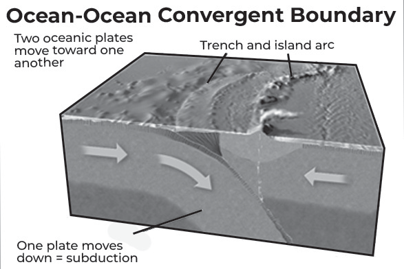
(Fig-Oceanic-oceanic convergence)
Continental-Continental Convergent Boundary
A continental-continental convergent boundary happens when two tectonic plates made of continental crust collide. Similar to oceanic-oceanic convergent boundaries, this collision involves the compression of the same type of crust. However, unlike oceanic-oceanic boundaries, subduction does not occur here.
Continental crust is not very dense; in fact, it’s buoyant compared to the semi-fluid layer beneath it called the asthenosphere. This means that if there was a force pushing continental crust down into the mantle, the low-density crust would push itself back up, similar to how a cork floats in a glass of water.
What happens at these convergent boundaries?
If there’s any dense oceanic crust attached to one of the plates, it might sink into the mantle. But when two plates made of continental crust collide, they will crash into each other.
During this collision, the crust will bend, thicken, and create huge mountain ranges. Some of the world’s most famous mountain ranges, like the Himalayas, were formed this way when continental plates collided.
Because continental crust doesn’t sink into the mantle like oceanic crust does, it can last for billions of years. Geoscientists can study rocks on continents to learn about Earth’s early history.
Examples of continent-continent convergent boundaries include the collision of the India Plate with the Eurasian Plate, forming the Himalaya Mountains, and the collision of the African Plate with the Eurasian Plate, forming mountain ranges from the Alps to the Zagros Mountains in Iran. The Rocky Mountains in North America were also formed this way.
It’s important to note that continent-continent convergent boundaries usually start with at least one plate containing oceanic crust. This is because most of the Earth’s surface is covered by oceanic crust. Initially, the boundary forms a subduction zone, but once all the oceanic crust has subducted, it becomes a continent-continent boundary. This process also contributes to the formation of supercontinents.
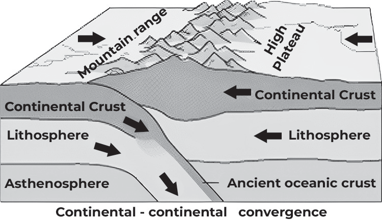
(Fig- Subduction of Indian plate beneath Eurasian Plate)