Whatsapp 88106-52225 For Details
Get Free IAS Booklet
Get Free IAS Booklet
CLASSIFICATION OF MOUNTAINS
There are 3 main types of mountains/mountain ranges, classified on the basis of the process of formation.
Fold mountains
Block mountains
Volcanic mountains
Fold mountains
Fold mountains are created when two tectonic plates come together, either two continental plates or a continental and an oceanic plate. As the plates collide, they force layers of sedimentary rocks upwards, forming folds or wrinkles in the Earth’s crust. These mountains are typically made of sedimentary rocks and are usually found along the edges of continents. This is because sedimentary rocks tend to accumulate in thick layers along continental margins. When the plates collide, these layers of rock get crumpled and folded, similar to how a tablecloth bunches up when pushed across a table.
There are two types of fold mountains: young and old.
• Young fold mountains are between 10 to 25 million years old, such as the Rockies and the Himalayas.
• Old fold mountains are over 200 million years old, like the Urals and the Appalachians in the USA.
• These mountains are formed through a long process called orogeny, which takes millions of years. During orogeny, the Earth’s crust is pushed and folded, creating the mountains we see today.
Parts of a Fold
When rocks bend due to tectonic plate movements, they form folds. The raised part of a fold is called an anticline, and the lowered part is called a syncline. The sides of the fold are called limbs, and the top is called the crest. The imaginary line that divides the fold into two equal parts is called the axis of the fold or axial plane.
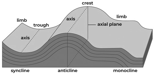
(Fig- Elements of fold)
Symmetrical Folds
These folds are also known as normal or upright folds. In these folds, the imaginary line dividing the fold is vertical, and both sides of the fold are equal in length. The limbs, or sides, of the fold dip equally in opposite directions. Depending on whether it’s an upward or downward bend, it can be called a symmetrical anticline or a symmetrical syncline.
Asymmetrical Folds
Asymmetrical folds are bends in rock layers where the limbs are not the same length and they dip at different angles on either side of the fold’s central line, called the hinge line. The axial plane, or imaginary line dividing the fold, is tilted or inclined.
Overturned Folds
These are folds where the axial planes are inclined, and both limbs of the fold dip in the same general direction. The amount of dip may or may not be the same on both sides.
Over folding refers to an extreme degree of folding where one of the limbs (called the reversed limb) has rotated more than 90 degrees from its original position. The other limb is called the normal limb.
Isoclinal Folds
These are a group of folds where all the imaginary lines dividing the folds are parallel, which means all the limbs of the folds dip at equal angles. These groups can consist of both anticlines (upward folds) and synclines (downward folds).
Recumbent Folds
These are very extreme types of folded rock layers where the axial plane becomes almost horizontal. In these folds, one limb lies directly underneath the other limb, so if you were to drill a hole from the surface of the upper limb, it would pass through the lower limb as well. The lower limb is often referred to as the inverted limb or the reversed limb.

(Fig- Types of Fold)
Fault/Block Mountain
Fault block mountains have steep rock faces and form when immense pressure from underground causes a large mass of rock to break away along a fault line. One side of the fault rises up while the other side sinks down. A well-known example of this process on a smaller scale is the 1906 San Francisco earthquake, where a series of tremors caused the rock layers to shift by as much as 21 feet along the fault line that ran through the city.
Note: In India, prominent examples of fault or block mountains include the Satpura and Vindhya range.
Additional Points
•The term “block mountain” was coined by W. M. Davis to describe mountains formed by the breaking of the Earth’s crust. Other names for these mountains include “fault- block mountain” by D. W. Johnson and simply “fault blocks” by Strahler. These terms all refer to mountains created by the fracturing of the Earth’s crust.
• A specific type of block mountain with symmetrical boundaries is called a horst, which can also be referred to as a “horst mountain.” However, the term “block mountain” can also be used more broadly to describe tilted fault blocks and complex mountain ranges formed by faulting.
About Fault
• A fault is a crack or break in the Earth’s crust where rocks on opposite sides move due to pressure from forces like compression or tension.
• Faults can be vertical, horizontal, or at any angle in between. While the angle of a fault plane is usually consistent, it can vary along its length.
• When rocks slide past each other in a fault, the block above the fault is called the hanging wall, and the block below is called the footwall. The fault strike is the direction of the line where the fault intersects the Earth’s surface, and the dip is the angle at which the fault plane slopes from horizontal.
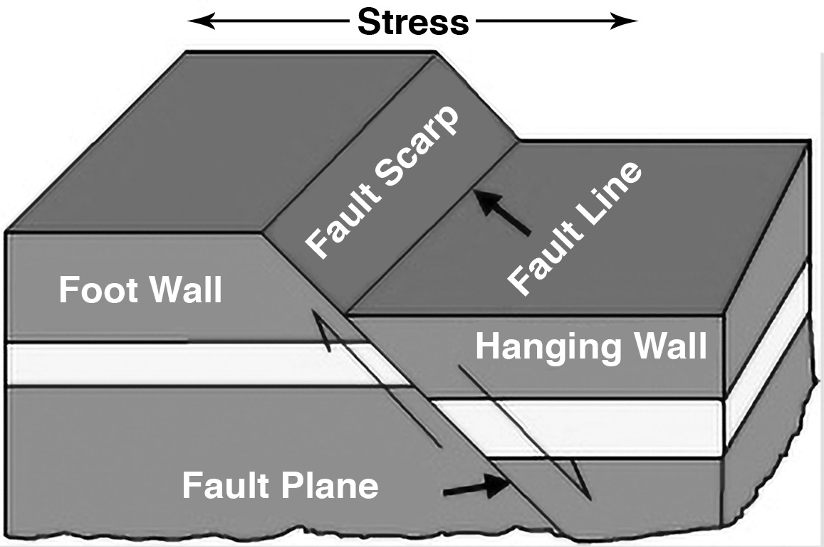
• Faults are categorized based on their angle of dip and how the rocks on either side move relative to each other. Normal dip-slip faults occur when the Earth’s crust is being pulled apart, causing the hanging wall to slide down relative to the footwall. These faults are common and can be found in many mountain ranges and rift valleys, which are formed when the Earth’s crust stretches apart.
• A graben is a block of land that drops down between two normal faults that are angled toward each other. On the other hand, a horst is a block of land that is uplifted between two normal faults that are angled away from each other.
Volcanic mountains
Volcanic mountains are formed from the lava and tephra that come out of a volcanic vent. A type of endogenic process is volcanic activity. Different landforms, such as a plateau (if a volcano is not explosive) or a range of mountains (if the lava is explosive in nature), might arise depending on the explosive nature of the volcano.
Mount Fuji in Japan is an apt example of a volcanic mountain.
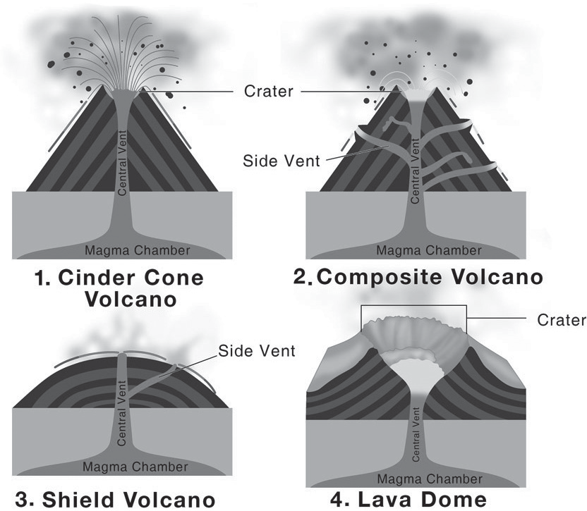
Different kinds of volcanic mountains
• Cinder Cone Mountains: These mountains are formed when material blasted out of a volcano falls back down, creating a cone-shaped hill. They don’t usually grow very big.
• Shield Volcanoes: These volcanoes are built up by many layers of low-viscosity lava that flows easily. The lava can spread out over long distances, creating wide, gently sloping mountains.
• Stratovolcanoes or Composite Volcanoes: These volcanoes are made up of many layers of ash, rock, and hardened lava. They can be some of the largest and most impressive volcanoes in the world due to their explosive eruptions and layers of material built up over time.
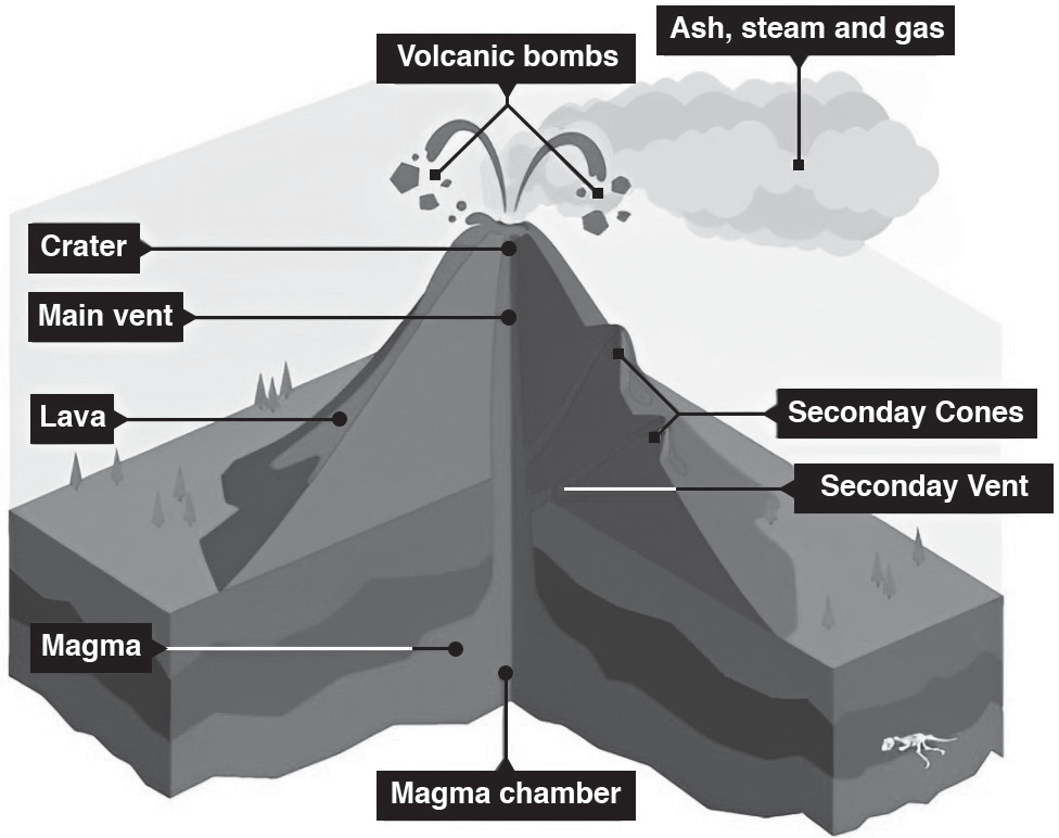
Volcanoes Eruptions
MAJOR MOUNTAIN RANGES IN THE WORLD
A mountain range is a collection of mountains and large land formations situated close to each other, often arranged in a line. These mountain ranges exist all over the world and are mainly created due to movements in the Earth’s crust known as tectonic activity.
•Examples of mountain ranges include the Himalayas, Alps, Atlas, Andes, and Rockies. These mountain ranges form connected chains that have important effects on the local weather patterns and climate conditions in the regions they span.
•The Atlas Mountains in North Africa (Morocco, Algeria, and Tunisia) block moisture from the Mediterranean Sea, leading to more rainfall in the region and less rainfall in the Sahara Desert.
• The Andes Mountains in South America, being the longest continental range, affect how much rain falls in certain areas and create a dry area known as a rain shadow in the Atacama Desert.
•The Rocky Mountains in North America, stretching from Canada to the United States, produce warm winds called Chinooks that melt snow and affect rainfall patterns, creating areas with less rain, known as rain shadows, in certain regions of North America.
These mountain ranges are really important because they affect the weather in nearby areas. This, in turn, affects how people live there and can have big impacts on things like culture, money and geography.
The Himalayas
•The Himalayas are really famous mountains. They were made when two big pieces of the Earth’s surface (Indian Plate and
Eurasian Plate) crashed into each other.
The Himalayas have the tallest mountain in the world, Mount Everest, which is super high at 8,848.86 meters tall.
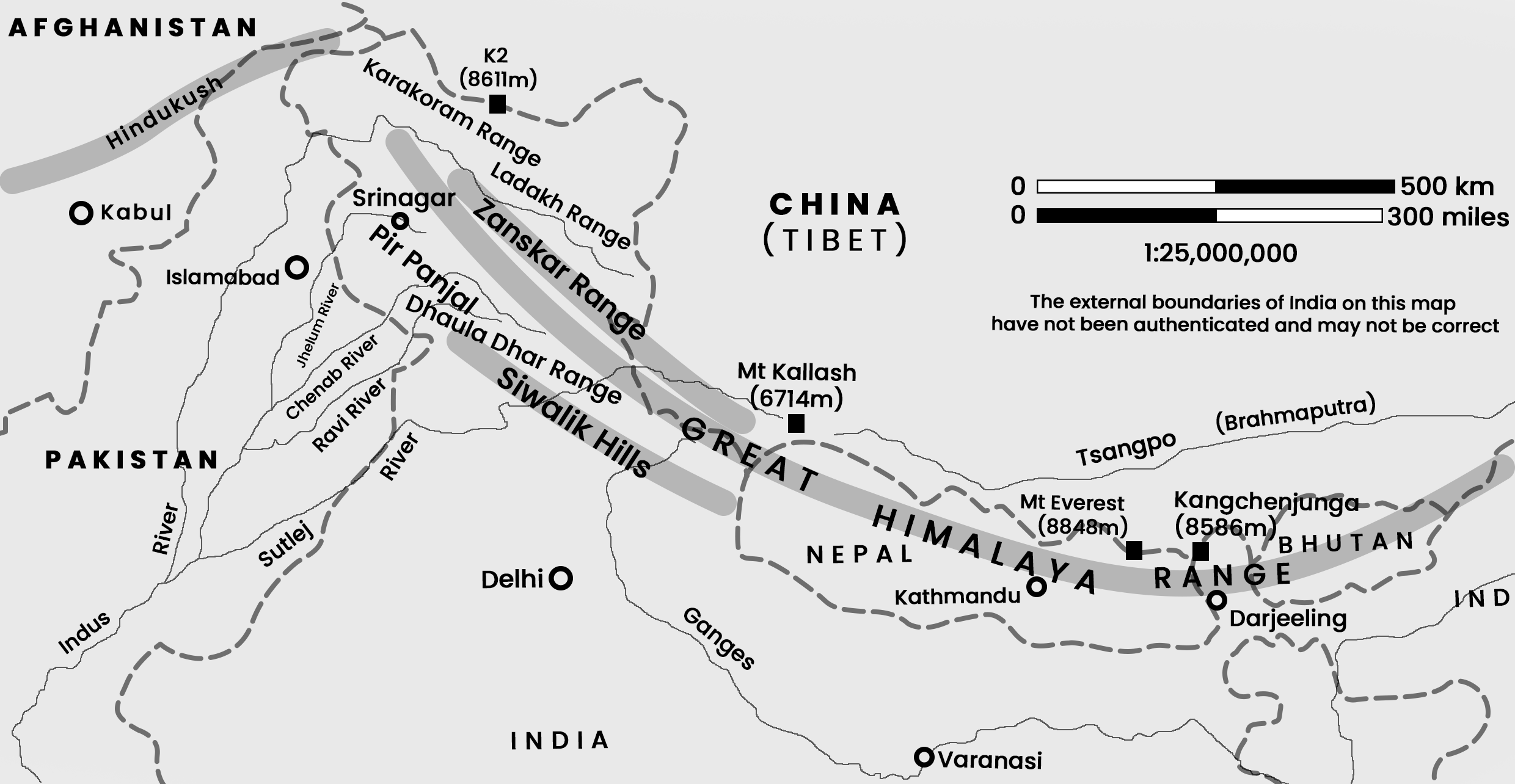
(Fig-The Himalayan Mountain Ranges)
•The Himalayan Mountains are split into three parts that run alongside each other, like three rows of hills: the Shivalik Hills, the Lower Himalayan Range, and the Greater Himalayas.
• The Himalayas are where three important rivers in India originate from: the Ganga, the Brahmaputra and the Indus.
•The Himalayas are amongst some of the newest mountains on Earth, and they’re mainly made up of rocks that were pushed up from the ground and changed by heat and pressure.
• The Himalayas, a massive mountain range that stretches over 2500 kilometers in a curved shape, protect India from cold winds coming from the Tibetan plateau. They also block the monsoon winds, which affects rainfall patterns in India. Because of this, some areas get less rain, creating deserts like the Taklamakan and Gobi Desert.
• Additionally, the collision that formed the Himalayas also created other features like the Arakan Yoma highlands in Myanmar and the Andaman and Nicobar Islands in the Bay of Bengal.
The Alps
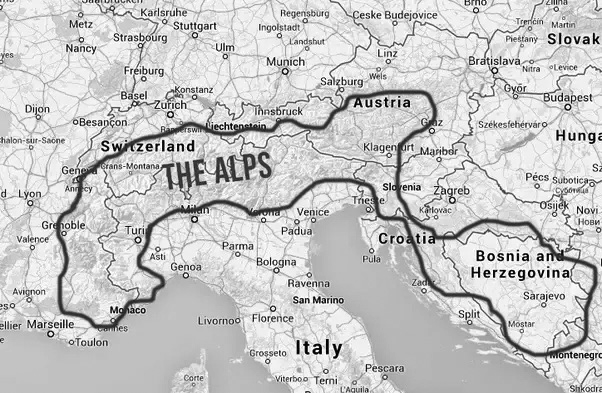
•Formation of the Alps: The Alps were formed as a result of the collision between the African and Eurasian tectonic plates. This collision pushed the Earth’s crust upwards, creating the towering mountain range, we know today.
• Geographical Features: The Alps are the highest mountain range in Europe, stretching over 1200 kilometers. Because of their size and location, they significantly influence precipitation patterns and create local winds like the Foehn and Mistral.
Influence on Local Winds: The presence of the Alps affects the direction and intensity of local winds which are important weather phenomena in the region.
• Grenoble: Grenoble, located in France, is the largest city in the Alps and is often referred to as the “capital of the Alps” due to its significant presence within the mountain range.
Fig-The Alps
The Rocky Mountains
• Formation: The Rockies were formed between 80 to 55 million years ago through geological processes.
• Subdivisions: They are divided into four main subranges: the northern Rockies, the Middle Rockies, the southern Rockies, and the Canadian Rockies.
• Population Density: The Rocky Mountains are not densely populated, with only around 4 people per square kilometer living there.
• Chinook Winds: The size and location of the Rockies play a crucial role in the formation of Chinook winds, which are warm, dry winds that occur in the region.
• Rainfall and Rain-shadow Effect: The mountains intercept moisture-laden winds from the Pacific Ocean, leading to significant rainfall on their windward side. However, they also create a rain-shadow effect, causing deserts to form on their leeward side in Southwest of North America.

The Andes
• The Andes is the tallest mountain range outside of Asia and the longest one above water on Earth. The highest peak in the Andes is Aconcagua, which is 6,961 meters high and is located in Mendoza, Argentina.
• The Andes creates a rain shadow effect, meaning it blocks rain clouds and causes dry conditions in the Atacama Desert.
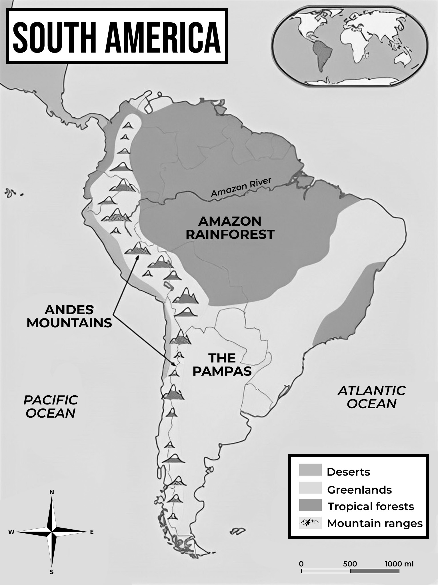
(Fig-The Andes)
• Ojos del Salado in the Andes is the tallest active volcano globally, reaching 6,893 meters in height. It’s a type of volcano called a stratovolcano.
• Chimborazo, at 6,263.47 meters, has the farthest point from the Earth’s center due to the equatorial bulge, making it even farther than Everest.
• The Patagonian Desert forms because the Andes block rain clouds, creating dry conditions on the opposite side, which is known as the leeward side.
The Atlas
• The Atlas Mountains stretch about 2,500 kilometers across Northern Africa.
• They used to be the habitat of the now-extinct Barbary lion and the Atlas bear.
• The mountains catch moist winds, leading to lots of rainfall in the area between them and the Mediterranean Sea.
• However, they also create a rain shadow effect, causing less rainfall in the Sahara Desert region.
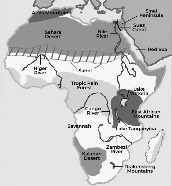
(Fig-Atlas Mountains)
The Southern Alps
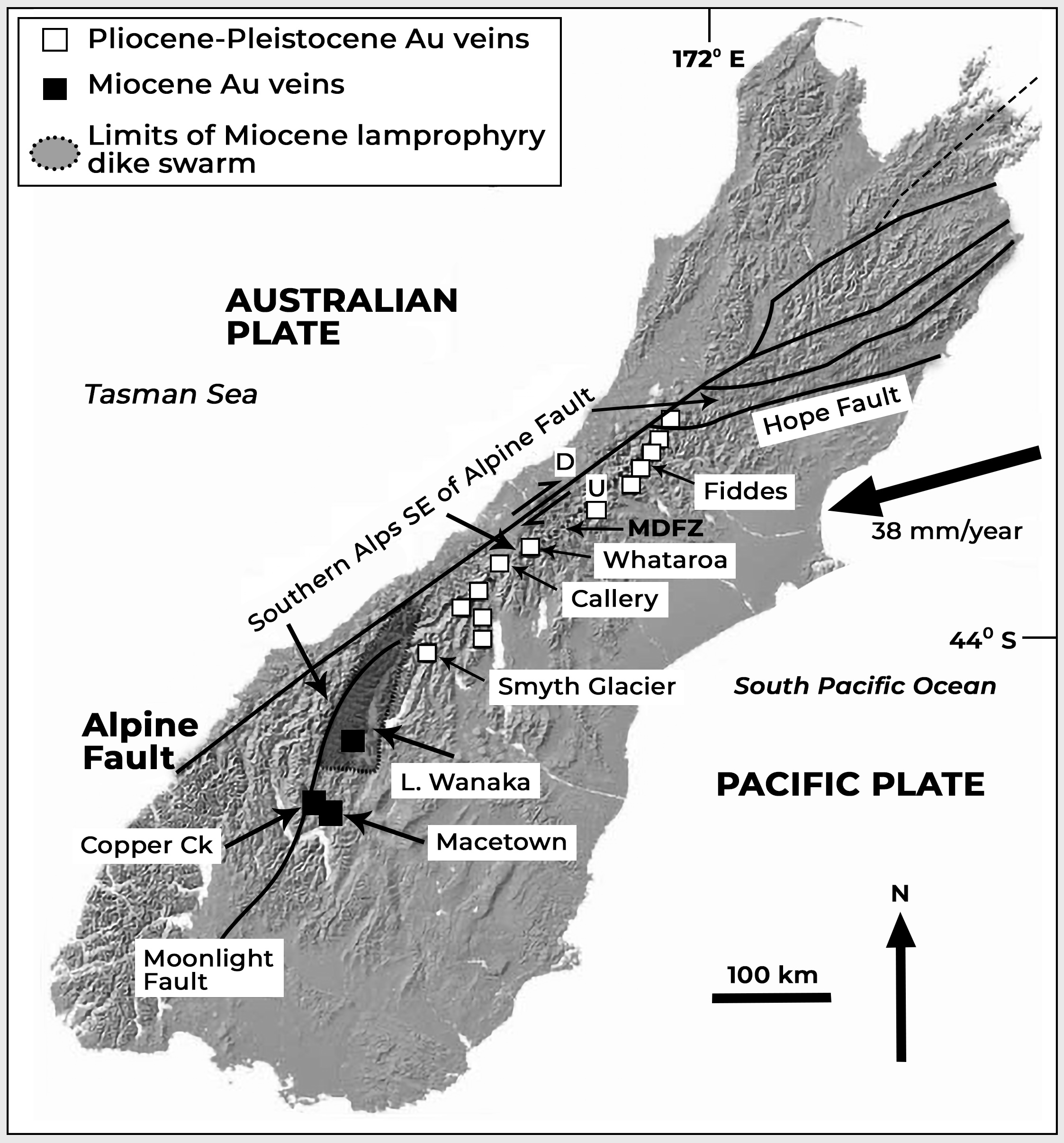
(Fig-The Southern Alps in New Zealand)
The Southern Alps is a mountain range located on the South Island of New Zealand.
It stretches for about 500 kilometers.
In the Maori language, the range is called “K Tiritiri o te Moana,” which translates to “the Mirage of the ocean.”
Ural Mountains/Urals

• The Urals are a long mountain range extending for 2,500 kilometers.
• They serve as the traditional dividing line between Europe and Asia, marking the boundary between these two continents.
The Urals stretch from the Arctic Ocean in the north to the northwestern areas of Kazakhstan, crossing over the Ural River.
The World’s Tallest Mountain Ranges
1. Himalayas- The Himalayas are the tallest and youngest mountain range on Earth, with Mount Everest, the world’s highest peak, towering at 8,848 meters (29,029 feet) above sea level. They act as a barrier between the Tibetan Plateau to the north and the flat plains of the Indian subcontinent to the south. The Himalayas consist of more than 100 peaks rising over 7,300 meters (24,000 feet) high. Stretching for 2,500 kilometers (1,550 miles), the Himalayan range extends from Nanga Parbat in Pakistan to Namcha Barwa in Arunachal Pradesh, India.
2. Karakoram - The Karakoram is a significant mountain range in Central Asia, spanning 500 kilometers from Afghanistan to Central and South Asia. It serves as the meeting point for the borders of Tajikistan, Afghanistan, China, Pakistan, and India. Within the Karakoram, there are many peaks rising over 7,620 meters above sea level, including K2, the second-highest peak in the world at 8,611 meters.
3.Hind u Kush – The Hindu Kush is an 800-kilometer-long mountain range stretching from the Afghanistan-Pakistan border to northern Pakistan. It’s part of the Hindu Kush Himalayan Region and a vast Alpine zone, containing the largest watershed in central Asia. The range has many tall, snow-capped peaks, with Tirich Mir being the highest at 7,708 meters above sea level. The Hindu Kush shares similarities with the Karakoram range, especially on its eastern edge. Historically, the mountain passes through the Hindu Kush have been strategically important in military invasions of the Indian Subcontinent and remain significant in modern warfare in Afghanistan.
4. Pamirs - The Pamir Mountains, with the highest peak Kongur Tagh at 7,649 meters, are centered around a geological uplift called the Pamir Knot. This knot gives rise to several other Asian mountain ranges such as the Karakoram, Hindu Kush, Tian Shan, and Kunlun ranges. The name “Pamir” refers to the high grasslands in the eastern part of the mountains, especially near Afghanistan and China. Most of the Pamirs are within Tajikistan’s borders, but parts extend into China, Afghanistan, and Kyrgyzstan. The heart of the Pamir Mountains lies in Tajikistan’s highlands. Historically, the Pamirs were part of the Silk Road, a significant trade route connecting Europe and China.
5. Andes – The Andes Mountains are the longest chain of mountains on land, found in South America. They extend for about 8,900 kilometers (5,500 miles), running from the southern tip of South America all the way through several countries including Colombia, Venezuela, Ecuador, Argentina, Peru, Bolivia, and Chile, reaching the northern coast of the Caribbean. The Andes are the tallest mountains in the Western Hemisphere and contain the highest peak in South America, called Aconcagua, which stands at 6,962 meters (22,841 feet) tall.
LAKES
A lake is a body of water that is surrounded by land. There are millions of lakes in the world. They are found on every continent and in every kind of environment—in mountains and deserts, on plains and near seashores.
• It varies greatly in size. Some measure only a few square metres and are small enough to fit in your backyard. Such small lakes are often referred to as ponds.
• Other lakes are so big that they are called seas.
The Caspian Sea, in Europe and Asia, is the world’s largest lake.
A lake is a body of water surrounded by land, found across various environments worldwide.
• Size Variation: Lakes vary greatly in size. Some are small, measuring only a few square meters, and are often referred to as ponds. These small lakes may be found in backyard gardens or natural settings.
• Range of Sizes: Other lakes are much larger and can be vast in size. Some are so immense that they are referred to as seas due to their size and expansiveness.
• Global Distribution: Lakes can be found on every continent and in diverse environments, including mountains, deserts, plains, and near seashores. They form through various geological processes such as glaciation, tectonic activity, volcanic activity, and erosion.
• Caspian Sea: The Caspian Sea, located between Europe and Asia, is recognized as the world’s largest lake. Despite being called a sea due to its size and saline nature; it is technically classified as a lake.
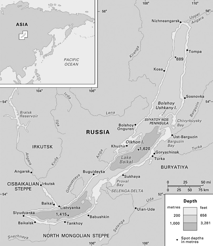
Lake Baikal
Lakes exhibit significant variation in depth, with some being relatively shallow while others are exceptionally deep.
Lake Baikal: Located in Russia, Lake Baikal is the world’s deepest lake, with depths reaching nearly 2 kilometers (more than 1 mile) in some areas. Despite covering less surface area than Lake Superior, one of North America’s Great Lakes, Lake Baikal is approximately four times deeper and holds nearly as much water as all five Great Lakes combined. Its immense depth contributes to its significance as a natural wonder and a unique ecosystem.
Shallow Lakes: In contrast, there are many lakes around the world that are relatively shallow, to the extent that a person could easily wade across them. These shallow lakes are often found in regions with low precipitation, high evaporation rates, or in areas where sediment accumulation has reduced their depth over time.
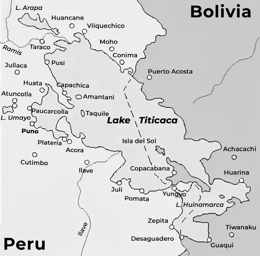
Lake Titicaca
Lakes are found at various elevations across the globe, from high mountain ranges to low-lying plains.
Lake Titicaca: Situated in the Andes Mountains between Bolivia and Peru, Lake Titicaca is one of the highest lakes in the world, located at an elevation of approximately 12,500 feet above sea level. It is renowned for its cultural significance, unique biodiversity, and stunning scenery.
Dead Sea: On the other end of the spectrum, the Dead Sea, located between Israel and Jordan, is the lowest lake on Earth, situated approximately 1,300 feet below sea level. It is famous for its exceptionally high salinity and mineral-rich waters, making it a popular destination for therapeutic and recreational purposes.
The water in lakes is sourced from various inputs, including precipitation (rain and snowfall), melting ice, inflowing streams and rivers and groundwater seepage. Most lakes contain freshwater, though some, like the Dead Sea, have high levels of salinity due to evaporation and mineral concentration over time.
Lakes can be categorized as either open or closed based on the mechanisms through which water exits the lake. Here’s an explanation of open and closed lakes
• Open Lakes: Open lakes have outlets through which water can leave the lake, such as rivers or other watercourses. When water exits a lake via these outlets, it is considered an open lake. Most freshwater lakes are open because they typically have outflows that maintain a balance of water inflow and outflow, preventing the accumulation of salts.
• Closed Lakes: Closed lakes lack outlets through which water can exit the lake, and therefore, water loss primarily occurs through evaporation. As water evaporates from the lake, it leaves behind dissolved solids, primarily salts, leading to an increase in salinity over time. Closed lakes are often saline or salty due to this accumulation of salts.
• Examples of closed lakes include the Great Salt Lake in the U.S. state of Utah, which is the largest saline lake in North America. Its high salinity makes its water saltier than the ocean. Surrounding the Great Salt Lake are vast salt flats, where the lake’s water has evaporated, leaving behind stretches of white salt.
• In India, there are several important saltwater lakes, including Didwana, Kuchaman, Sargol and Khatu in the state of Rajasthan. These lakes are examples of closed lakes where water loss primarily occurs through evaporation, leading to high salinity levels and the formation of salt flats in surrounding areas.
Formation of Lake
Formation of lakes can be attributed to different ways
• Earth Movement
• Glaciation
• Volcanic Activity
• Erosion
• Deposition
• Human and Biological Activities.
Lake Formation by the Earth movement
Lake formation resulting from earth movement, particularly tectonic activity, can lead to the creation of various types of lakes with distinct characteristics.
• Tectonic Lakes: Tectonic lakes form due to the deformation of the Earth’s crust, resulting in warping, bending, fracturing, and sagging. These geological processes create depressions in the Earth’s surface, which subsequently fill with water, forming lakes of significant size and depth. Tectonic lakes are often characterized by their large dimensions and considerable depth.
•Rift Valley Lakes: Rift valley lakes are a specific type of tectonic lake formed by faulting along rift zones, resulting in the creation of elongated, deep troughs known as rift valleys. These valleys occur between parallel faults, with their floors often situated below sea level. Water collects in these troughs, forming lakes with unique geological and hydrological features. One of the most famous examples of rift valley lakes is found in the East African Rift Valley, which stretches through several countries, including Zambia, Malawi, Tanzania, Kenya, and Ethiopia. Lakes such as Tanganyika, Malawi, Rudolf, Edward and Albert are located within this rift valley system.
Examples of tectonic lakes include
• Lake Titicaca: Situated in the Andes Mountains, Lake Titicaca is the highest navigable lake in the world and sits within a large depression formed by tectonic activity.
• Caspian Sea: The Caspian Sea, also known as a large saline lake, formed within a vast depression resulting from tectonic processes. It is the largest lake by both surface area and volume, spanning several countries in Eurasia.
Formation by Glaciation
• Cirque Lakes or Tarns: Cirque lakes, also known as tarns, form in circular hollows left behind by glaciers at the heads of valleys in mountainous regions. These hollows, called cirques or corries, are often armchair- shaped and have over-deepened floors. When filled with water, they become cirque lakes. For example, Red Tarn in the English Lake District is a cirque lake. Cirque lakes occupying glacial troughs are elongated and deep, known as ribbon lakes, such as Lake Ullswater.
• Kettle Lakes: Kettle lakes form in depressions on outwash plains left by the melting of stagnant ice masses, such as glaciers. These depressions are irregular due to the uneven surface of moraines and are typically not very large or deep. Examples include the meres of Shropshire in England and the kettle lakes of Orkney in Scotland.
• Rock-Hollow Lakes: Rock-hollow lakes are formed by ice-scouring when valley glaciers or ice sheets carve out hollows on the surface. These lakes are abundant in Finland, earning the country the nickname “Suomi” or the Land of Lakes. Rock-hollow lakes are characterized by their glacial origins and are often found in regions with extensive glaciation history.
Lake Formation by Volcanic Activity
Crater and Caldera Lakes: During a volcanic explosion, the top of a volcanic cone may be blown off, creating a natural hollow known as a crater. Subsequent subsidence of the crater walls can lead to the formation of a larger depression called a caldera. These depressions are typically dry and bounded by steep cliffs, often circular in shape.
In dormant or extinct volcanoes, rainwater may accumulate within the crater or caldera, forming a crater or caldera lake. These lakes lack a superficial outlet and are sustained by direct precipitation within the basin.
• Crater Lake, Oregon, USA: Crater Lake, located in Oregon, USA, is a prime example of a crater lake formed within a caldera. It occupies the collapsed caldera of Mount Mazama, which erupted approximately 7,700 years ago. Crater Lake is renowned for its deep blue color and clarity, making it a popular tourist destination.
• Lake Toba, Sumatra: Lake Toba, situated in northern Sumatra, Indonesia, is another significant caldera lake. It formed approximately 75,000 years ago during a catastrophic eruption of the super-volcano Mount Toba. Lake Toba is one of the largest volcanic lakes in the world and is surrounded by stunning landscapes and cultural heritage sites.
•Lake Avernus, Naples, Italy: Lake Avernus, located near Naples, Italy, is a small crater lake surrounded by volcanic terrain. In ancient times, Lake Avernus was believed to be the entrance to the underworld in Greek and Roman mythology.
Lake Formation by Erosion
• Karst Lakes: Karst lakes form as a result of the solvent action of rainwater on limestone, a process known as karstification. Over time, rainwater dissolves the limestone, carving out solution hollows in the rock. When these hollows become filled with debris, lakes may form within them. Additionally, the collapse of limestone roofs of underground caverns can expose long, narrow lakes that were once underground.
• An example of a karst lake is Lac de Chaillexon, Jura Mountains: Lac de Chaillexon is located in the Jura Mountains and is an example of a karst lake formed through erosion processes.
Lake Formation by Deposition
• Lakes Due to River Deposits: Rivers may alter their course during floods by cutting across meandering loops, leaving behind horseshoe-shaped channels known as ox-bow lakes. For example, ox-bow lakes occur on the floodplains of the Lower Mississippi in the USA and the Rio Grande in Mexico. The Kanwar Lake in Bihar, Asia’s largest freshwater ox-bow lake, is an example of a residual ox-bow lake formed due to the meandering of the Gandak River, a tributary of the Ganga.
• Lakes Due to Marine Deposits: Coastal lagoons may be formed by the action of winds and waves isolating them along coasts through the building of spits or bars. These lagoons, characterized by shallow water, are enclosed by narrow spits of land comprising mud, sand and shingle. They may drain away at low tide. Such lagoons are commonly found off the deltas of large rivers like the Nile and the Ganges. In East Germany and Poland, lagoons are referred to as haffs. Coastal sand dunes pushed landwards by strong onshore winds may enclose marshy lagoons. This type of lagoon is well developed in the Lands of southwest France.
Human and Biological Activities
• Man-Made Lakes: Man-made lakes are created by humans through the construction of dams across river valleys. These dams impound river water, creating reservoirs or artificial lakes. Man-made lakes serve various purposes, including water supply, irrigation, flood control and hydroelectric power generation. Among these, Lake Mead above the Hoover Dam on the Colorado River in the USA is one of the most impressive examples. Lake Mead, located in the U.S. states of Arizona and Nevada, was formed when the Hoover Dam was built during the Great Depression. It serves as a reservoir for water storage and hydroelectric power generation through power plants at the dam.
• Lakes Made by Animals: Some animals, such as beavers, exhibit remarkable behavior in building dams across rivers using wood. These beaver dams can persist for a long time and alter the natural flow of water, creating lakes or ponds. One example is Beaver Lake in Yellowstone National Park, USA, which was formed by beavers building dams across waterways. Beaver Lake is a testament to the significant impact that animal behaviors, can have on shaping landscapes and creating habitats for other species.
Largest lakes by continent
Here are the largest lakes by continent
• Africa: Lake Victoria, which is also the second largest freshwater lake on Earth. It is part of the Great Lakes of Africa.
• Antarctica: Lake Vostok.
• Asia: Lake Baikal is the largest lake entirely within Asia. The Caspian Sea, the largest lake on Earth, straddles the Europe-Asia border.
• Australia: Lake Eyre, which often remains dry but fills with water during periods of heavy rainfall.
• Europe: Lake Ladoga is the largest lake in Europe,followed by Lake Onega, both located in northwestern Russia.
• North America: Lake Superior, one of the Great Lakes of North America.
• South America: Lake Maracaibo, which is often considered a bay due to its wide opening to the sea. The largest freshwater lake in South America is Lake Titicaca, which is also the highest navigable body of water on Earth at 12,507 feet above sea level.
Important Lakes of the Earth Caspian Sea
• The Caspian Sea, also known as Mazandaran Sea, Hyrcanian Ocean, or Khazar Sea, holds several distinctions in terms of its size and geographical features:
• It is the world’s largest inland body of water, often categorized as both the largest lake and a full-fledged sea.
• Geographically, it is located within an endorheic basin, meaning it does not drain into any ocean or sea. Instead, it is bordered by land on all sides.
• The Caspian Sea is situated between Europe and Asia. It lies to the east of the Caucasus Mountains, west of the expansive steppe regions of Central Asia, south of the fertile plains of Southern Russia in Eastern Europe and north of the mountainous Iranian Plateau in Western Asia.
• Border countries: TARIK
T – Turkmenistan
A – Azerbaijan
R – Russia
I – Iran
K – Kazakhstan
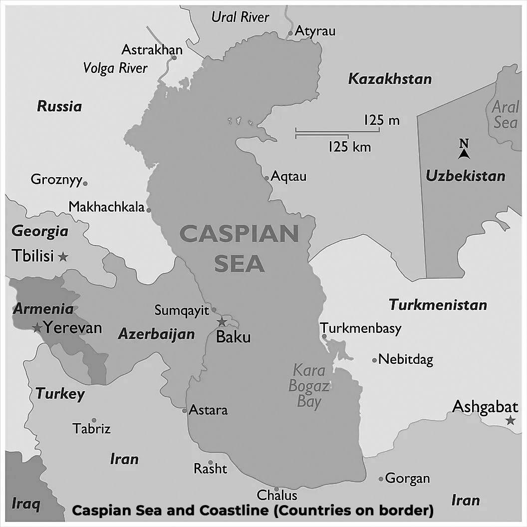
(Fig- Caspian Sea)
Lake Baikal – Deepest Lake
• Location: Situated in southern Siberia, Russia, Lake Baikal is a rift lake formed within the Baikal Rift Zone.
• Volume: It is renowned as the largest freshwater lake by volume globally, containing approximately 22 to 23% of the world’s fresh surface water resources.
•Surface Area: Lake Baikal ranks as the seventh-largest lake in the world by surface area, encompassing a vast expanse of land.
• Maximum Depth: With a maximum depth of 1,642 meters (5,387 feet), Lake Baikal stands as the deepest lake on Earth.
• Age: Lake Baikal holds the title of being the world’s oldest lake, estimated to be around 25 to 30 million years old, making it a geological marvel.
• Shape: The lake exhibits a long, crescent shape, adding to its unique and distinctive features.
• UNESCO World Heritage Site: Recognizing its exceptional natural and cultural significance, Lake Baikal was designated as a UNESCO World Heritage Site in 1996.
Lake Tanganyika – Longest Lake
• Length: Lake Tanganyika is recognized as the longest lake globally, stretching approximately 660 kilometers in length.
• Volume: It ranks as the second-largest lake by volume, containing a substantial amount of water.
• Depth: Lake Tanganyika is the second deepest lake in the world, following Lake Baikal.
Great Lakes
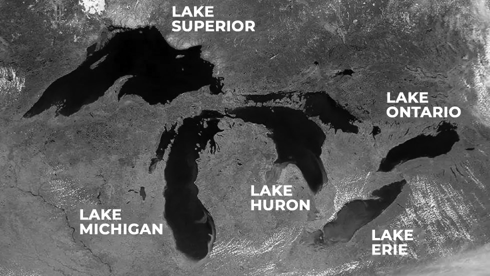
(Fig- Great lakes)
The Great Lakes of North America, known for their size and importance, possess several noteworthy characteristics
• Interconnected Lakes: The Great Lakes comprise a series of interconnected freshwater lakes that ultimately connect to the Atlantic Ocean via the Saint Lawrence Seaway.
• Composition: The Great Lakes consist of five primary lakes, namely Superior, Michigan, Huron, Erie and Ontario, arranged from west to east.
• Size Order: The lakes are ordered from largest to smallest as follows: Superior, Huron, Michigan, Erie and Ontario.
• Largest Continental Lake: Lake Superior holds the distinction of being the largest continental lake globally by area.
• Largest Lake within One Country: Lake Michigan is recognized as the largest lake entirely within one country, spanning significant portions of the United States.
• Water Transport Corridor: The Great Lakes serve as a crucial water transport corridor for the transportation of bulk goods, facilitating trade and commerce across the region.
• Connectivity: The Great Lakes Waterway connects all the lakes, allowing for seamless navigation and transportation. Additionally, the Saint Lawrence Seaway provides a route for ships to access the Atlantic Ocean from the Great Lakes region.
Red Sea
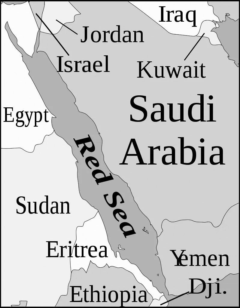
The Red Sea, characterized by its geographical and hydrological features, holds several significant attributes
• Bordering Countries: The Red Sea is bordered by six countries. On the eastern shore are Saudi Arabia and Yemen, while on the western shore are Egypt, Sudan, Eritrea and Djibouti.
• Geographic Location: Situated between Africa and Asia, the Red Sea serves as an inlet of the Indian Ocean.
• Salinity: Renowned for its high salinity levels, the Red Sea ranks among the most saline bodies of water worldwide.
• Connectivity: The Red Sea is connected to the Indian Ocean to the south through the Bab-el-Mandeb strait and the Gulf of Aden, providing a vital maritime route between these two bodies of water.
Adriatic Sea
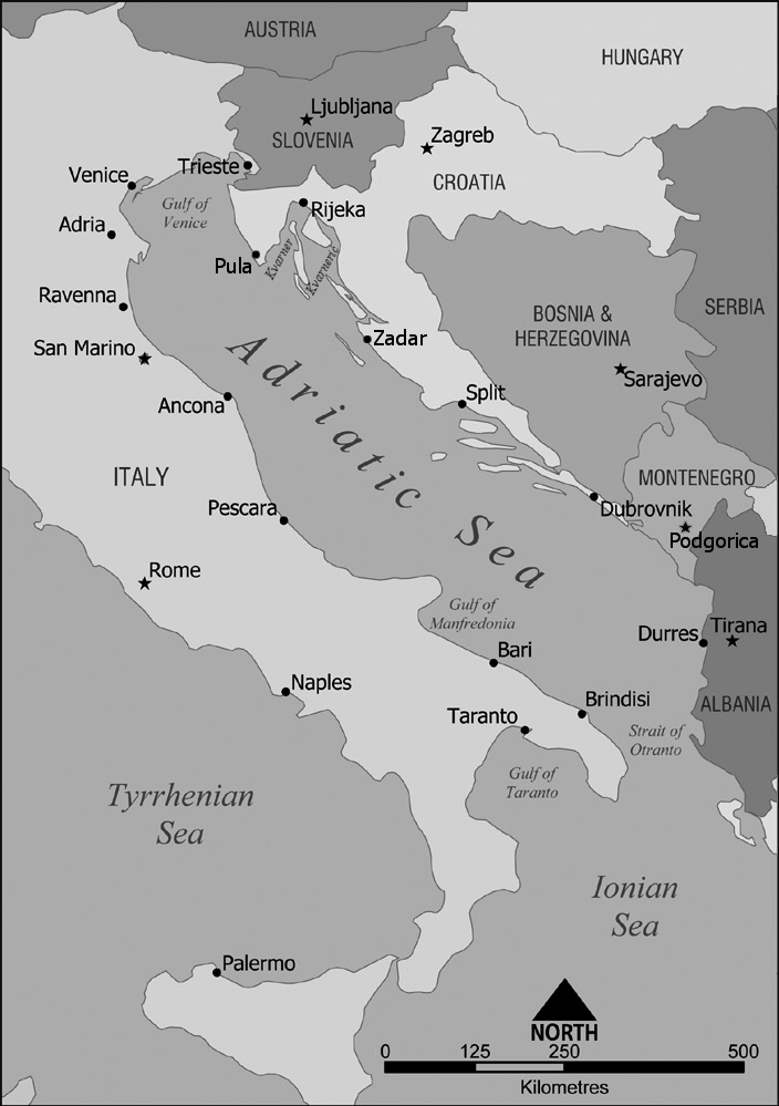
• The Adriatic Sea, situated in the Mediterranean region, serves as a significant body of water with the following characteristics
•Mediterranean Arm: The Adriatic Sea is a prominent arm of the Mediterranean Sea, extending between the Italian Peninsula and the Balkan Peninsula.
• Geographic Divide: It acts as a natural divide between the Italian Peninsula and the Balkan Peninsula, shaping the coastline of both regions.
• Bordering Countries: The Adriatic Sea is bordered by several countries, including Albania, Croatia, Bosnia and Herzegovina, Italy, Slovenia and Montenegro. These nations share coastlines along the Adriatic and have significant maritime interests in the region.
Dead Sea
• Alternate Name: Also referred to as the Salt Sea due to its extremely high salinity levels.
• Geographic Location: The Dead Sea is located in the Middle East, bordering Jordan to the east and Palestine and Israel to the west
• Lowest Elevation: It holds the distinction of being Earth’s lowest elevation on land, with its shores lying at the lowest point of land on Earth’s surface.
Aral Sea
• Geographic Location: Situated between Kazakhstan in the north and Uzbekistan in the south, the Aral Sea was historically one of the largest lakes in the world.
• Environmental Degradation: Since the 1960s, the Aral Sea has experienced a steady decline in its water levels. This decline has been primarily attributed to the diversion of rivers that fed into the sea as part of Soviet irrigation projects.
African Great Lakes
• Geographic Location: These lakes are situated within the East African Rift Valley, a geologically significant region known for its tectonic activity and diverse landscapes.
• Composition: The African Great Lakes include several prominent bodies of water, among which Lake Victoria is notable as the second-largest freshwater lake globally. Additionally, Lake Tanganyika stands out as the world’s second-largest lake by volume and the second-deepest lake overall.

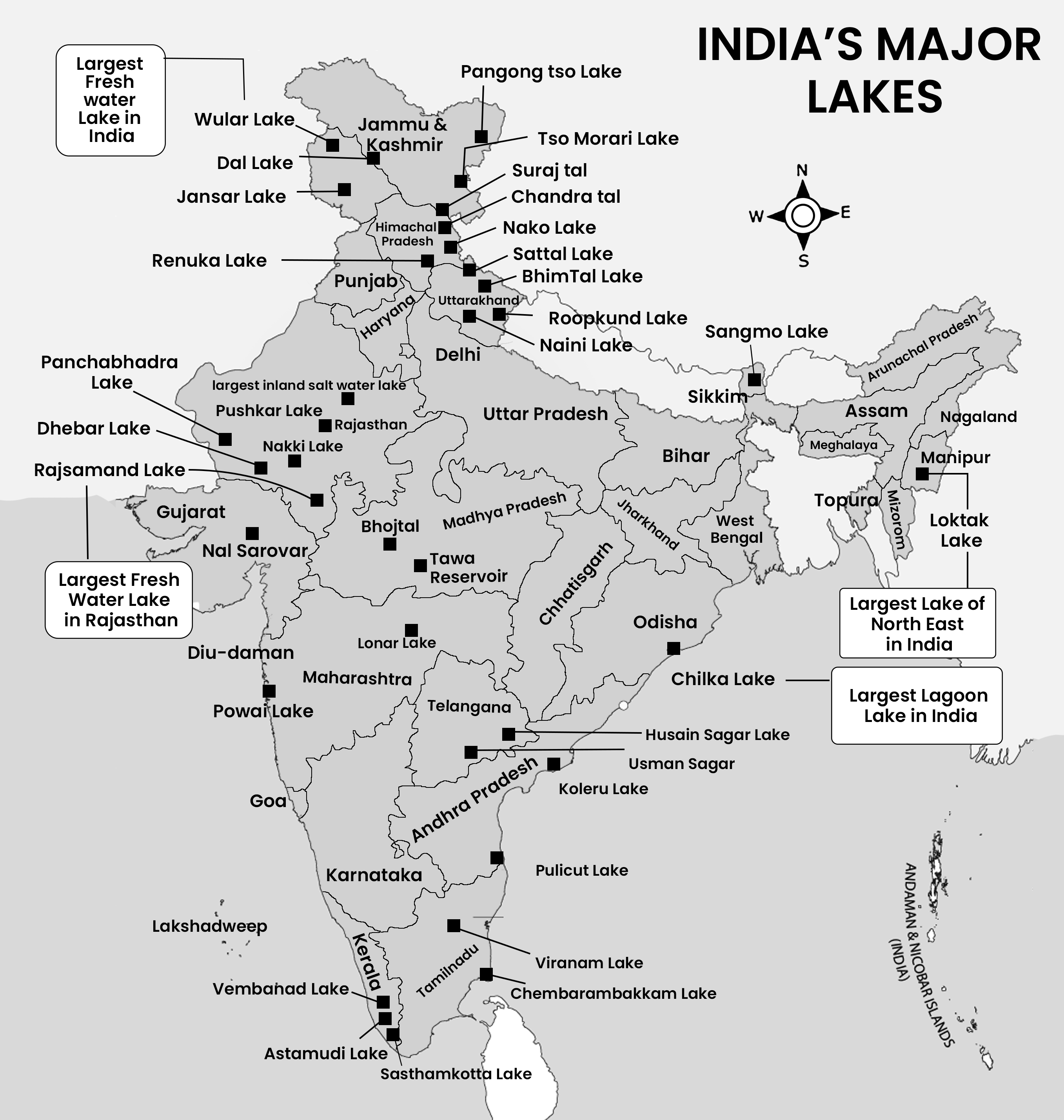
Important Lakes of India
PLATEAU
Plateaus are defined as elevated landforms that rise sharply above the surrounding terrain on at least one side. They can vary in characteristics, ranging from flat and expansive surfaces to hilly or rolling landscapes. Plateaus are found on every continent and cover approximately one-third of the Earth’s surface, making them significant features of the planet’s topography. In addition to mountains, hills, and plains, plateaus complete the spectrum of landforms on Earth.
Plateau surfaces can exhibit various features, including extreme flatness, hilly or rolling terrain, plain-like expanses, and may even be dissected by streams and glaciers. These diverse characteristics contribute to the unique landscapes found on plateaus.
Plateaus are of great importance to humans, as they offer valuable resources and opportunities for various activities
• Agricultural Use: Plateau regions can be utilized for agricultural purposes, including livestock rearing and crop cultivation. The relatively flat or gently sloping terrain of some plateaus makes them suitable for farming practices.
• Mineral Resources: Plateaus often contain valuable mineral deposits, making them important sources of resources such as metals, ores and fossil fuels. Mining activities on plateaus contribute significantly to the global economy.
• Tourism: Plateaus are often characterized by stunning natural scenery, unique geological formations, and diverse ecosystems, making them popular destination for tourists and outdoor enthusiasts. Tourist attractions on plateaus include national parks, scenic viewpoints, and cultural landmarks.
Plateaus are formed through various geological processes, each contributing to the creation of different types of plateaus such as Faulting, Folding, Volcanic Activity, Downwarping among others.
Formation of plateau
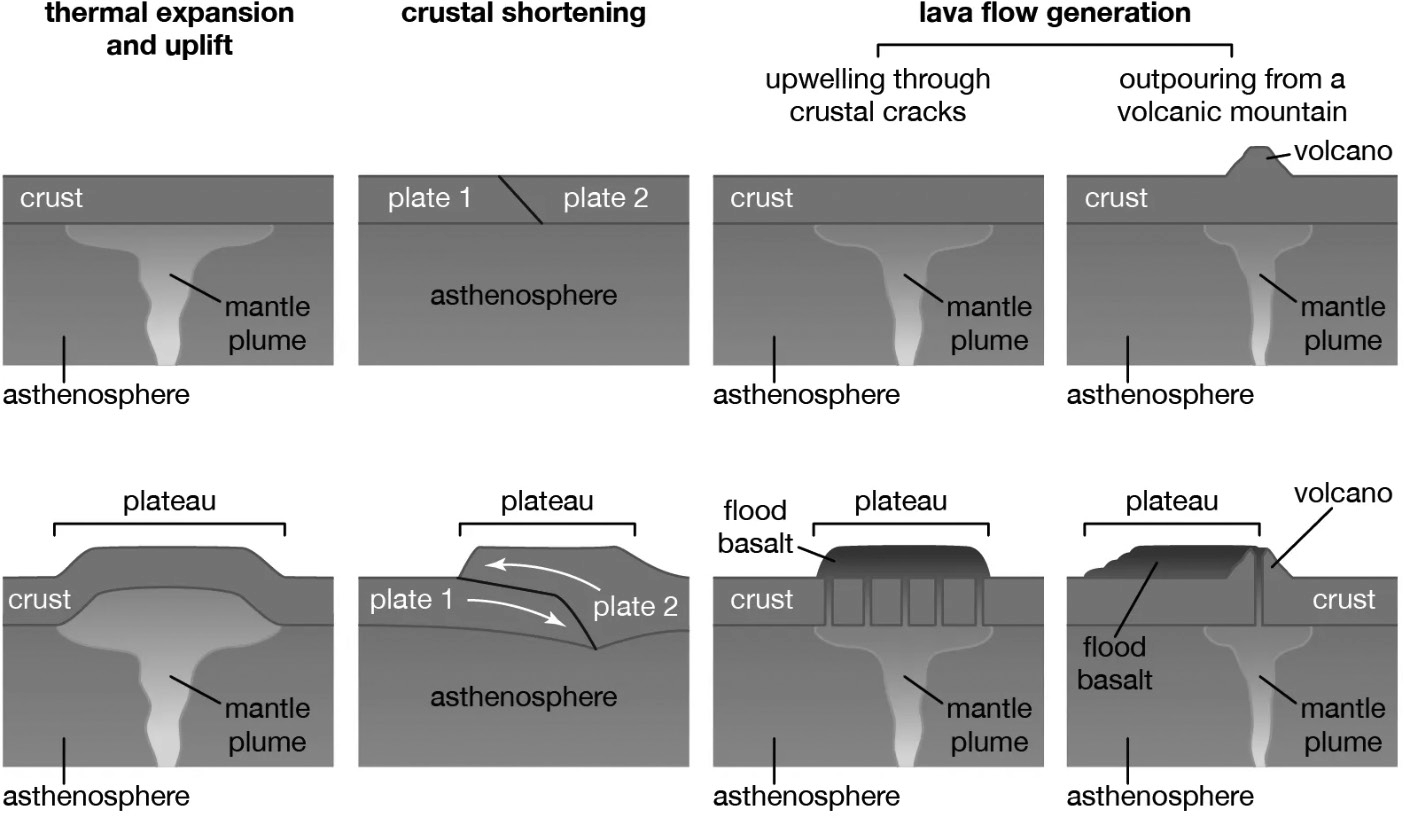
The formation of plateaus can be attributed to three primary tectonic processes, which are analogous to those responsible for creating mountain ranges. These processes include volcanism, crustal shortening, and thermal expansion:
• Volcanism: Plateaus formed by volcanic activity typically result from eruptions associated with hot spots. One example is the Deccan Traps in India, which cover the Deccan Plateau and formed around 60-65 million years ago. This volcanic activity occurred in the same hot spot beneath which the present-day Réunion volcanic island is located. Lava plateaus, such as the Columbia Plateau in the northwestern United States, can also form from extensive lava flows and volcanic ash burying pre-existing terrain. The volcanism involved in these situations is often linked to hot spots.
• Crustal Shortening: Plateaus formed through crustal shortening result from the pushing, breaking, or folding of one piece of land over another. Examples include the Tibetan Plateau and the Altiplano. These plateaus typically feature very flat, broad valleys surrounded by steep hills and mountains.
• Thermal Expansion: Thermal expansion occurs when the underlying lithosphere warms rapidly over a wide area, such as through the uplift of warm material from the underlying asthenosphere. This warming and expansion of the upper mantle cause the overlying surface to rise, forming plateaus. Examples include the high plateaus of East Africa and Ethiopia. Additionally, magma rising from the Earth’s interior to the surface can also contribute to the formation of massive plateaus.
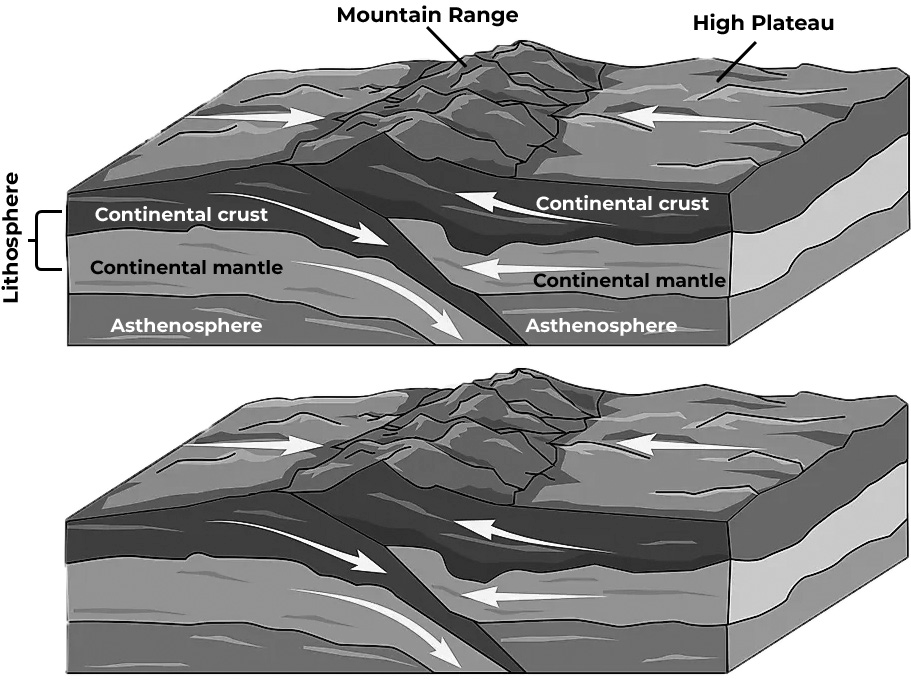
Crustal Shortening
Types of Plateaus
Since plateaus differ in terms of characteristics and appearances, the following types of plateaus exist
The Diastrophic Plateaus
The Diastrophic Plateaus, characterized by significant deformation of the Earth’s crust on a large scale, are formed through diastrophism—a geological process that leads to the creation of continents, basins, oceans and mountain ranges. These plateaus, known as diastrophic plateaus, are typically high in elevation and have undergone various modifications by erosion agents and minor earth movements, as well as volcanic activity, since their uplift.
Examples of diastrophic plateaus include
• The Ethiopian Highlands: Located in East Africa, the Ethiopian Highlands are a prime example of diastrophic plateaus. This region features rugged terrain and high elevations, with plateaus and mountain ranges formed, through tectonic processes and uplift.
• Tibetan Plateau: Often referred to as the “Roof of the World,” the Tibetan Plateau is the highest and largest plateau on Earth. It is characterized by its vast expanse of high-altitude terrain, including plateaus, mountains, and deep valleys. The plateau has been shaped by tectonic activity and uplift over millions of years, resulting in its distinctive landscape.
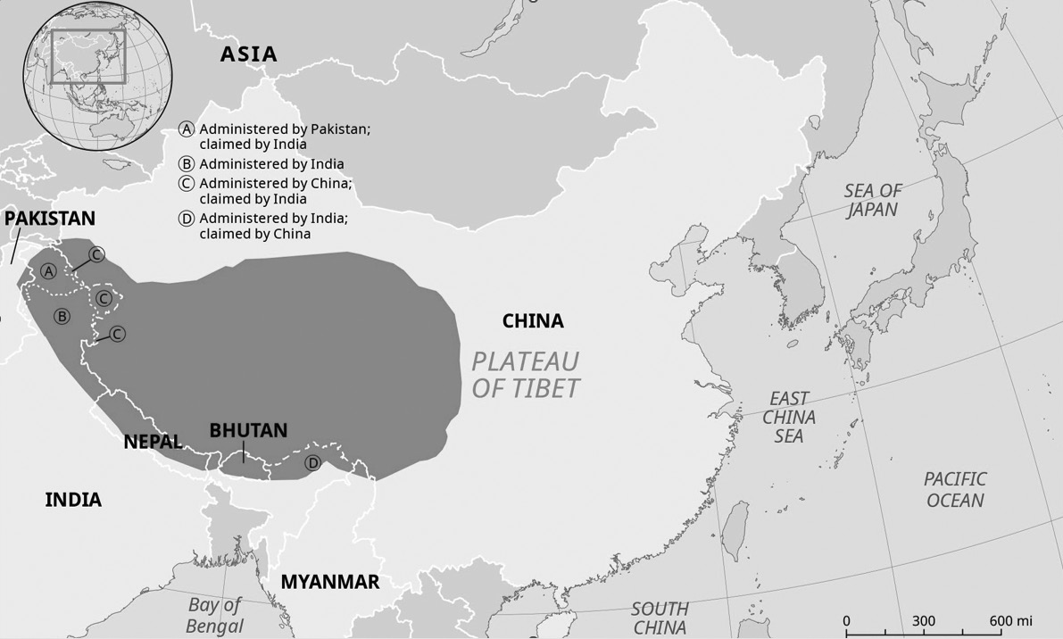
Tibetan Plateau
Border Plateaus
Border Plateaus, often situated adjacent to mountain ranges, owe their location to the same tectonic uplifts responsible for the formation of nearby mountains. These plateaus typically appear as land strips positioned between plains, often in coastal regions, and adjacent mountains. They serve as transitional zones between low-lying plains and elevated mountainous regions.
Examples of border plateaus include
• Colorado Plateau: Situated in the southwestern United States, the Colorado Plateau is characterized by its high elevation and unique geological features, including colorful canyons, mesas, and buttes. It borders the Rocky Mountains and extends into portions of Arizona, Utah, Colorado and New Mexico.
• Piedmont Plateau: Found along the eastern foothills of the Appalachian Mountains in the United States, the Piedmont Plateau is a region of rolling hills and low plateaus. It lies between the Atlantic Coastal Plain and the Appalachian Mountains and stretches across several states, including Virginia, North Carolina, South Carolina and Georgia.
Volcanic Plateaus
Volcanic Plateaus are formed through volcanic eruptions, where the buildup of lava over time creates elevated landforms. These plateaus, constructed primarily by the flow of lava, can vary in size and shape. In some cases, smaller volcanic plateaus are formed from resistant lava caps that protect the underlying land from erosion, maintaining their high elevation even as surrounding areas are worn away.
Examples of volcanic plateaus include
• Deccan Traps: Located in India, the Deccan Traps are one of the largest volcanic plateaus in the world. They were formed around 60-65 million years ago during a series of volcanic eruptions that covered the region with layers of basaltic lava flows. The plateau covers a vast area and is characterized by its flat, elevated terrain.
• Columbia Plateau: Situated in the northwestern United States, the Columbia Plateau is another significant volcanic plateau formed by extensive lava flows. It covers parts of the states of Washington, Oregon and Idaho, and was created by volcanic activity associated with the Columbia River Basalt Group. The plateau features a rugged landscape with deep canyons and basalt cliffs.
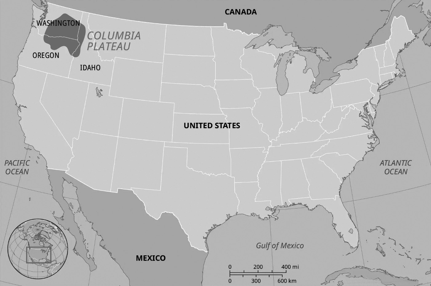
Columbia Plateau
Intermontane Plateau
• Intermontane Plateaus are among the most complex types of plateaus on Earth, characterized by their large size and high elevation. They exhibit various unique features on their surfaces and are often surrounded by mountain ranges.
• One of the prime examples of this type of plateau is the Tibetan Plateau, along with the Mexican Plateau and the plateau of Peru and Bolivia.
Domed Plateau
• Domed plateaus, as the name suggests, are plateaus characterized by their dome-shaped structures. These landforms typically result from geological processes such as faulting and folding. One example of a domed plateau is the Ozark Plateau, located in the United States of America.
• The Ozark Plateau covers a vast area of over 40,000 square miles and is situated primarily in the states of Missouri, Arkansas, Oklahoma and Kansas.
It was uplifted through processes of folding and faulting, resulting in the formation of a large dome- shaped landmass. The formation of the Ozark Plateau occurred during the Appalachian orogeny, a period of mountain-building that occurred towards the end of the Paleozoic era.
The Erosional Plateau
Erosional plateaus are primarily formed in semi-arid regions of the world. In these areas, streams and rivers gradually erode the highlands, resulting in the formation of flat, table- like surfaces known as plateaus. Unlike mountains, which typically have sharp peaks, erosional plateaus have a more subdued appearance due to the gradual erosion processes that shape them. One common type of erosional plateau is the dissected plateau.
Dissected plateaus
• Dissected plateaus are geological formations that result from the erosion of large and ancient plateaus over extended periods. These plateaus are typically formed due to upward movement in the Earth’s crust, which is often caused by the slow collision of tectonic plates. Over time, various physical factors such as rivers, winds and other natural agents erode the plateau, dividing it into smaller parts or dissecting it.
• These plateaus usually consist of both hard and soft rocks. Soft rocks are eroded more easily by erosion agents like rivers and winds, creating deep gorges or valleys, while the hard and resistant rocks remain as dissected plateaus.
• Prominent examples of dissected plateaus include the Chota Nagpur Plateau, Karnataka Plateau, Malnad region, and Bundelkhand and Baghelkhand in Madhya Pradesh, among others.
Characteristics of dissected plateaus include
• Formation through erosion: Dissected plateaus are primarily formed as a result of erosion processes acting on large, ancient plateaus.
• Moderate height: Dissected plateaus typically have moderate elevations compared to other landforms such as mountains.
• Formation of mesas and buttes: After erosion, dissected plateaus may form mesas and buttes, which are flat- topped hills with steep sides. These landforms are characteristic features of dissected plateaus.
Importance of Plateaus
Plateaus offer numerous benefits to both humanity and the overall well-being of the Earth’s surface.
Mineral deposits
• Plateaus contain a variety of minerals, including precious metals like gold and diamonds, as well as base metals like copper, iron, and manganese. These minerals have significant monetary value and are essential for various industries.
• Mining activities on plateaus provide employment opportunities and income for local communities and contribute to national economies. The extraction and sale of minerals generate revenue that can support livelihoods and economic development.
• Many plateaus around the world are known for their rich mineral deposits. Examples include the Massif Central in France, the Deccan Plateau in India, the Katanga Plateau in the Democratic Republic of Congo (known for copper ore) and the Kimberly Plateau in Australia (famous for diamond mines).
• Plateaus such as the Kimberly Plateau in Australia and regions in East Africa are renowned for their diamond mines. These precious gemstones are highly valued in global markets and contribute significantly to the economies of these regions.
• Plateaus also host other valuable minerals like manganese, coal and iron ore. For example, the Chota Nagpur Plateau in India is known for its rich deposits of manganese, iron and coal, which support the country’s industrial activities.
Waterfalls
Plateaus often feature waterfalls and river falls, which serve as essential sources of water for various human activities.
• Natural water sources: Waterfalls and river falls found in plateau regions provide natural sources of water for local communities. These water bodies are crucial for meeting basic human needs such as drinking, cooking and sanitation.
• Drinking water: The water flowing from waterfalls and river falls is often clean and fresh, making it suitable for drinking without extensive treatment. Local populations rely on these natural water sources for their daily hydration needs
• Other activities: In addition to drinking water, the waterfalls and river falls on plateaus support various activities such as agriculture, irrigation, and livestock watering. Communities utilize this water for crop cultivation, sustaining livestock and supporting other economic activities.
• Tourism and recreation: Waterfalls and scenic river falls attract tourists and outdoor enthusiasts to plateau regions, contributing to local economies through tourism revenue. Visitors come to admire the natural beauty of these water features and engage in recreational activities such as hiking, photography and nature exploration.
• Ecosystem support: Waterfalls and river falls create unique habitats and ecosystems, supporting diverse flora and fauna. These ecosystems contribute to biodiversity conservation and provide ecological services such as water purification and habitat for wildlife.
Extensive grasslands
Plateaus are often covered with extensive grasslands, which are vital for supporting a nomadic lifestyle and livestock rearing
• Nomadic lifestyle: The presence of abundant grasslands on plateaus makes them suitable habitats for nomadic communities. Nomads rely on these grasslands to support their traditional way of life, which involves moving with their livestock in search of fresh pasture and water sources.
• Livestock grazing: The grasslands on plateaus provide essential fodder for domestic animals such as cattle, sheep, and goats. Grazing livestock feed on the nutrient-rich grass, helping to sustain their health and productivity.
•Pastoralism: Plateaus support pastoralist communities who depend on livestock rearing for their livelihoods. These communities utilize the grasslands to graze their herds, which are often their primary source of food, income and cultural identity.
• Biodiversity: The grasslands on plateaus support diverse plant and animal species, contributing to ecosystem biodiversity. These ecosystems provide habitat for wildlife, including herbivores, carnivores and birds, creating a balanced ecological system
• Sustainable land use: Nomadic grazing practices on plateaus often follow sustainable land management techniques, allowing grasslands to regenerate and maintain their productivity over time. Rotational grazing and seasonal movement patterns help prevent overgrazing and soil degradation.
• Cultural significance: Grasslands on plateaus hold cultural significance for indigenous communities, who have traditionally inhabited these regions for generations. These grasslands are often central to the cultural identity, livelihoods and social practices of local populations.
• Fertile soils: The presence of fertile soils on volcanic plateaus, formed by the deposition of volcanic materials such as lava, ash, and pyroclastic flows, is advantageous for agriculture and other activities
•Agricultural productivity: Volcanic soils are rich in essential nutrients such as potassium, phosphorus and nitrogen, which are beneficial for plant growth. These soils have a loose texture and good drainage properties, allowing for efficient root penetration and water retention, which promotes crop growth and yield.
• Crop cultivation: Farmers utilize volcanic plateaus for cultivating a variety of crops due to the fertility of the soil. Staple crops such as maize, wheat, rice and potatoes, as well as cash crops like coffee, tea and fruits, thrive in these nutrient-rich soils. The fertile volcanic soils support diverse agricultural activities, contributing to food security and economic development in the region.
•Soil fertility management: Farmers on volcanic plateaus often employ sustainable agricultural practices to maintain soil fertility and productivity. Techniques such as crop rotation, organic matter addition, and soil conservation help prevent soil erosion, nutrient depletion and land degradation, ensuring the long-term sustainability of agricultural activities
•Economic opportunities: The fertile soils on volcanic plateaus create economic opportunities for local communities through agriculture-related businesses such as farming cooperatives, agro-processing industries, and agritourism ventures. These activities contribute to rural livelihoods, employment generation and income diversification.
MAJOR PLATEAUS OF THE WORLD

(Fig-Major Plateaus in the world)