Temperate Cyclone
INTRODUCTION
Temperate cyclones are referred to by various names such as mid-latitude depressions, extra-tropical cyclones, frontal depressions and wave cyclones.
These cyclones are active in the mid-latitudinal region, typically between 35 to 65 degrees latitude, in both the Northern and Southern Hemispheres.
Temperate cyclones generally move from west to east, with this movement being more pronounced during the winter seasons. They form where polar and tropical air masses meet, leading to the formation of fronts.
Most temperate cyclones form as wavelike perturbations on fronts. On weather maps, they are depicted as low- pressure areas surrounded by circular or elliptical isobars. When these isobars take on an elongated shape, the pressure system is referred to as a trough.
These cyclones are primarily observed in the Atlantic Ocean and northwest Europe. They exhibit characteristics developed over both oceanic and land surfaces.
The temperate zone experiences highly variable and cloudy weather, largely due to the convergence of different air masses. This convergence leads to the formation of fronts and the occurrence of cyclonic conditions.
The formation of temperate cyclones is primarily influenced by the interaction of warm and cold air masses, which leads to the formation of fronts. The stark contrast in temperature between these air masses is crucial for the genesis of a low-pressure center and the subsequent development of a temperate or extra-tropical cyclone. These cyclones can occur over large areas, including regions characterized by land, water, or their combination.
CHARACTERISTICS OF TEMPERATE CYCLONE
Extra-tropical cyclones are storm systems that occur in mid and high latitudes, away from the tropics.
They are characterized by low-pressure systems with associated cold fronts, warm fronts and occluded fronts.
These cyclones form along the polar front, initially with a stationary front.
Also known as mid-latitude storms or baroclinic storms, they feature cold air moving from the north and warm air from the south in the Northern Hemisphere.
As pressure decreases along the front, cold air moves southward and warm air moves northward, leading to an anticlockwise cyclonic circulation.
This circulation results in a well-defined extra-tropical cyclone, featuring both a cold front and a warm front.
Warm air pockets are compressed between the forward and rear cold air masses, causing clouds and rainfall ahead of the warm front.
The cold front eventually overtakes the warm front, lifting the warm air entirely and leading to the occlusion of the front, resulting in the dissipation of the cyclone.
Extra-tropical cyclones can originate over both land and sea and cover large geographical areas.
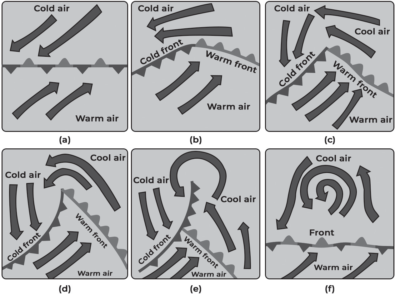
Formation of Front
STAGES OF FORMATION
Successive stages of development of a mid-latitude cyclone
Stage I: Stationary/Beginning - This stage involves the convergence of two air masses with contrasting physical properties and directions. Initially, the air masses move parallel to each other, leading to the formation of a stationary front. This marks the initial stage of cyclone development.
Stage II: Beginning of Young Adult - Also known as the “incipient stage,” this phase sees the warm and cold air masses penetrating into each other’s territories, resulting in the formation of a wave-like front.
Stage III: Mature - At this stage, the cyclone reaches full maturity, and the isobars become almost circular, indicating a well-developed cyclone.
Stage IV: Beginning of Occlusion Warm Sector - In this stage, the warm sector narrows in extent due to the advancement of the cold front, which overtakes the warm front.
Stage V: Occlusion - Occlusion marks the stage when the advancing cold front finally overtakes the warm front, leading to the formation of an occluded front.
Stage VI: Dissipation - In this final stage, one sector of the cyclone completely disappears and the occluded front is eliminated. Eventually, the cyclone dissipates and ceases to exist.
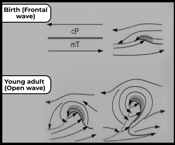
(Fig- Different phases of temperate cyclone)
Stage I: Stationary/ Beginning
During this stage, the cold air mass and warm air mass converge along a front, but they remain relatively stable and in contact with each other. This phase is often referred to as the stationary stage of front formation.
Despite the marked differences in temperature, moisture, and pressure between the two air masses, the conditions are not yet conducive to significant instability on a larger scale.
Over time, as the air masses interact, particularly at the fringe margin of the contact zone, the warm air mass begins to push eastward while the cold air mass exerts its influence to the west.
Towards the latter phase of this stage, the initially straight and flat front begins to show signs of curvature due to the advancing influence of the air masses.
This marks the transition to the second stage, the beginning of the young adult phase of cyclone development.
Stage II: Beginning of Young Adult
At the conclusion of the first stage, the boundaries between the two air masses become notably distinct.
The area where the warm air mass has the greatest impact is known as the warm front, located to the east in the Northern Hemisphere.
Also, the area where the cold air mass exerts significant influence is situated to the west in the Northern Hemisphere. In the northwestern part, the region occupied by the cold air mass is termed the cold sector, while in the southern and southeastern part, the warm air mass dominates, forming the warm sector.
These dynamics are governed by the general principles of winds associated with the Coriolis Effect and Ferrel’s law.
A similar configuration applies in the Southern Hemisphere, albeit in a mirror image.
The warm front exhibits greater instability due to the presence of higher moisture content, whereas the stability along the cold front is relatively higher as the cold air mass contains less moisture.
Increased moisture availability leads to greater instability in the air mass.
At the junction of the warm and cold fronts, instability is further heightened. The cold air mass pushes against the warm air mass, sharpening the junction. As a result, the warm sector begins to shrink and the bend of the front becomes sharper.
Since warm air is less dense than cold air, it is forced upward over the cold air mass.
As the warm air rises, it cools due to the influence of the cold air and increasing altitude, leading to condensation.
Condensation releases latent heat, contributing to further low-pressure development over the junction of the two fronts.
This marks the initial stage of temperate cyclone formation, as the cyclonic condition is already underway by the end of this stage, earning it the designation of the beginning of the young stage of a temperate cyclone.
Stage III: Mature
At the conclusion of the second stage, low air pressure has already initiated at the junction of the two fronts, primarily due to condensation. This low-pressure area attracts air from the surrounding regions, resulting in a significant vertical updraft of air.
The third stage marks the intensification of the processes observed in the second stage.
Intensification leads to the isobars becoming closer together, resulting in a sharp pressure gradient. The updraft of air moves swiftly in a whirling manner.
The invasion of the cold air mass becomes more pronounced, causing the warm sector to shrink further.
The sharp turns of the two fronts become more prominent, indicating the advanced stage of a temperate cyclone.
Since the prevailing wind patterns are westerlies, temperate cyclones tend to move eastward. As a result, wherever they make landfall, they bring about changing weather conditions.
By the conclusion of this stage, the combined front begins to lift, marking the initial phase of the cyclone’s diminishing strength.
Stage IV: Beginning of Occlusion
Occlusion refers to the compression or narrowing of the two distinct fronts formed during the earlier stages of the cyclone.
By the conclusion of the third stage, both fronts have moved closer together and eventually merge into what is known as the occluded front.
During the occlusion stage, the cyclone begins to weaken as the low-pressure system diminishes in intensity, and the wind velocity decreases.
The convergence of the two fronts becomes detached from the ground and remains suspended in the sky.
At ground level, the air is now dominated by the cold air mass, whereas initially, it was occupied by two different air masses.
The combined fronts continue to hang in the sky, while the warm sector has shifted above the ground.
There is still a discontinuity, but it now exists in the sky rather than on the ground.
Stage V: Late Occlusion
In the initial phase of occlusion, the temperate cyclone retains significant strength and dynamism, but as it progresses towards late occlusion, it undergoes substantial weakening.
During this stage, more and more areas become dominated by the cold air mass, which is denser and heavier compared to warm air.
The warm air areas are entirely controlled by the cold air, with the warm air being pushed up and cooling down due to the influence of the cold air and adiabatic cooling.
By the conclusion of this stage, the low-pressure system is completely dissipated, and normal atmospheric conditions are restored. The occluded front that was pushed up is also entirely removed.
These conditions signify the characteristics of the late occlusion stage of the temperate cyclone.
Stage VI: Dissipation
The dissipation stage marks the final phase of the temperate cyclone’s lifecycle.
During this stage, the cyclone weakens further, and the remaining areas of warm air are gradually replaced by cold air.
Eventually, the entire cyclone dissipates, and atmospheric conditions return to normal.
The dissipation stage signifies the end of the temperate cyclone’s influence and its integration back into the general atmospheric circulation