Whatsapp 88106-52225 For Details
Get Free IAS Booklet
Get Free IAS Booklet
SOURCE OF ENERGY ON THE EARTH
• The primary source of energy for the Earth’s surface is the Sun, which emits electromagnetic radiation across various wavelengths. Some of these wavelengths, particularly in the thermal and visible spectrum, heat both the Earth’s surface and its atmosphere.
• While geothermal energy from within the Earth also contributes to the surface’s energy, its impact on temperature distribution is minimal compared to solar radiation. Therefore, we’ll focus on the distribution of temperature resulting from solar radiation.
• Solar radiation reaching the Earth’s surface is known as insolation, which consists of short-wave electromagnetic rays. These rays are partially absorbed by the atmosphere and, upon reaching the Earth, are converted into long- wave radiation through reflection. The Earth’s surface receives this radiant energy at a rate of about two calories per square centimeter per minute.
• The distribution of global temperature is understood in two main ways: horizontally and vertically. However, before discussing the direct temperature distribution over the globe in these two perspectives, it’s essential to examine the factors that influence temperature.
FACTORS AFFECTING DISTRIBUTION OF INSOLATION
The amount of insolation reaching the Earth’s surface and its effectiveness per unit area depends on the following factors:
The Angle of Incidence or the Inclination of the Sun’s Rays:
The angle at which the Sun’s rays hit the Earth’s surface, known as the angle of incidence, plays a crucial role in determining the amount of solar radiation received at a particular location. This angle varies depending on the latitude of the location and the time of year.
The apparent movement of the Sun across the sky is limited between the Tropic of Cancer and the Tropic of Capricorn. As one moves towards the poles from the equator, the angle of incidence increases, meaning the Sun’s rays hit the Earth’s surface at a sharper angle. Consequently, the amount of solar radiation received decreases as you move towards the poles due to the increased obliquity of the Sun’s rays.
Latitude
Latitude, or the distance north or south of the equator, is one of the most significant factors influencing the uneven heating
of the Earth’s surface and atmosphere. This uneven heating leads to variations in temperature across the globe.
The intensity of heating from the Sun determines the temperature of the Earth’s surface, and this, in turn, affects temperature distribution. Generally, the highest amount of solar energy is received on or near the equator. As one moves away from the equator towards the poles, the amount of energy received from the Sun decreases, resulting in lower temperatures.
The Earth’s thermal zones are divided into three main
categories:
Torrid or Tropical Zone: This zone extends from 30 degrees north to 30 degrees south latitude.
Temperate Zone: These zones are located between 30 to 60 degrees north and south latitude and extend from the tropics towards the polar regions.
Frigid Zone: The frigid zones lie between 60 to 90 degrees north and south latitude, encompassing the polar regions.
Altitude
Altitude refers to the height above sea level, and it has a significant impact on temperature. As altitude increases, temperature typically decreases. This is because the Earth’s surface is primarily heated by the Sun’s energy.
The air in contact with the surface gets heated first, and then this heat is transferred to the surrounding atmosphere through various processes (Conduction, Convection and Advection).
One reason for lower temperatures at higher altitudes is that the atmosphere becomes less dense with increasing altitude. With fewer air molecules present, there are fewer opportunities for heat to be retained, leading to a decrease in temperature. Additionally, the presence of dust particles, water vapor, aerosols and other solid substances in the lower atmosphere contributes to absorbing incoming solar radiation as well as terrestrial longwave radiation. This absorption of heat helps to keep the lower atmosphere relatively warmer compared to the upper atmosphere, which is cleaner and contains fewer solid particles.
Land-Sea Differential
The land-sea differential refers to the unequal distribution of land and water on Earth’s surface. This imbalance plays a significant role in shaping temperature variations across different regions.
• The temperature contrast between land and water is primarily due to the unique properties of water. Water has the ability to absorb and release heat more slowly than land, making it less prone to temperature fluctuations. As a result, bodies of water tend to maintain relatively stable temperature conditions compared to land areas, which experience more rapid changes in temperature.
• This contrast in temperature between land and water is studied through the analysis of “temperature anomalies.” Temperature anomalies refer to deviations from the expected or average temperature for a specific location or time period. By examining these anomalies, scientists can better understand the temperature variations between land and water and their impacts on weather patterns and climate.
Prevailing Winds
• Prevailing winds, especially those coming from the ocean, can significantly influence the climate of coastal areas. These winds carry the moderating influence of the sea, resulting in cooler summers and milder winters along coastal regions. This effect is more pronounced on the side of the land facing the prevailing winds, known as the windward side.
• On the windward side, the influence of the oceanic winds helps to keep temperatures relatively stable throughout the year. The presence of the sea acts as a buffer, preventing extreme temperature fluctuations.
• However, on the leeward side or the inland areas, the moderating effect of the sea is not felt as strongly. These areas do not receive the cooling influence of oceanic winds and can experience more extreme temperatures, with hotter summers and colder winters.
Aspects of Slope:
The characteristics of slopes, including their direction and angle, play a significant role in determining the amount of solar radiation received in a particular area.
• Direction and Angle: The direction in which a slope faces and its angle influence how much sunlight it receives. Slopes that are more exposed to the sun’s direct rays receive higher amounts of solar radiation compared to those facing away from the sun.
• Solar Radiation Distribution: Due to differences in solar radiation, settlements and agricultural activities tend to concentrate on slopes that receive more sunlight. In many valleys, settlements and cultivation are primarily found on southern slopes, as they receive more solar radiation. In contrast, northern slopes often remain forested because they receive less sunlight.
• Observation in Himalayan Region: This phenomenon is particularly noticeable in regions with significant topographical variations, such as the Himalayas. In these areas, settlements and agricultural activities are strategically located on southern slopes to take advantage of increased solar radiation.
Ocean Currents:
Ocean currents play a crucial role in influencing the temperature of nearby land areas.
Temperature Influence: Warm ocean currents raise the temperatures of coastal areas, while cold ocean currents lower them. For example, in higher latitudes, eastern coasts often experience lower temperatures compared to western coasts due to the influence of cold ocean currents.
Example of North Atlantic Drift: An example of this influence is the North Atlantic Drift, which is an extension of the warm Gulf Stream. This current helps keep winter temperatures in Great Britain and much of Western Europe warmer than expected for their latitudes.
Effect on Prevailing Winds: The moderating effects of ocean currents are carried far inland by prevailing winds. This means that even regions located far from the coast can experience temperature changes influenced by ocean currents.
Three Ways of Transfer of Heat Energy
Heat energy from solar radiation is transferred to the Earth through three mechanisms:
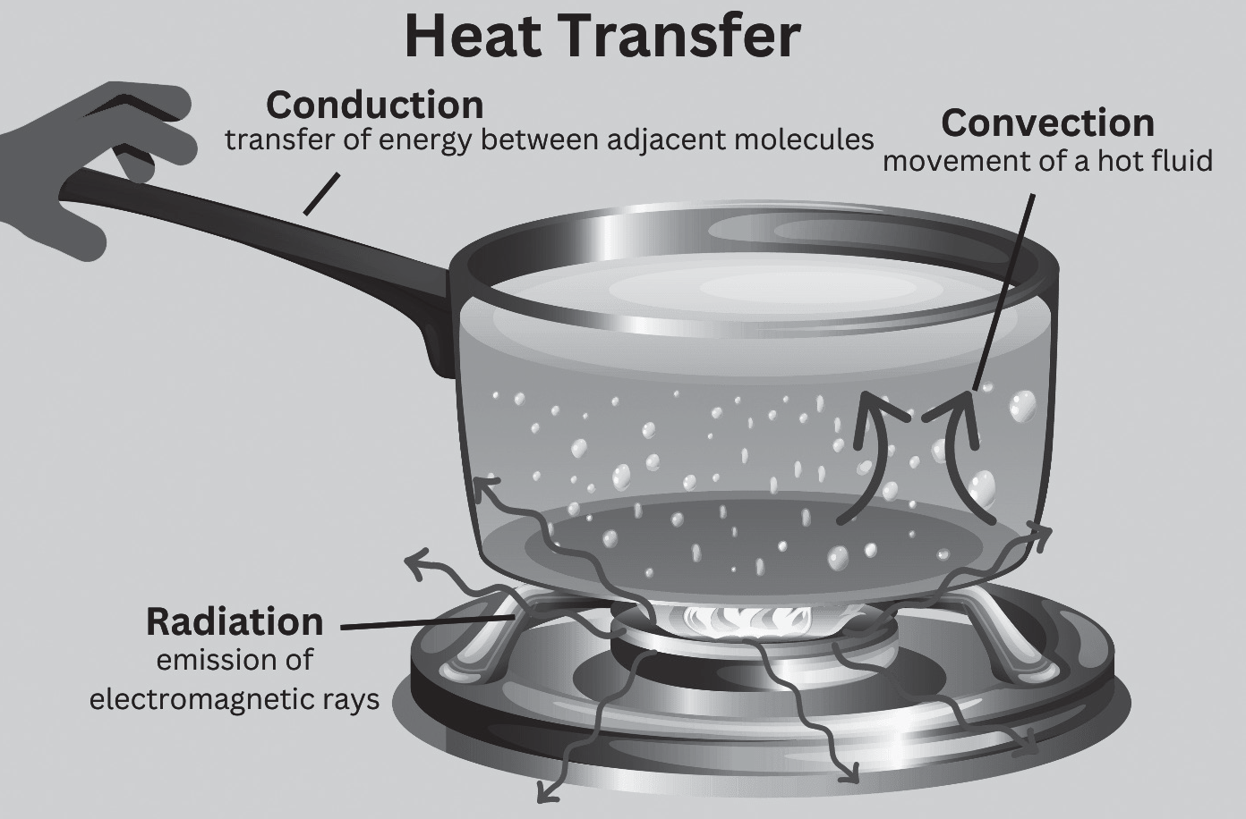
Conduction: The air in contact with the land gets heated slowly and the upper layers in contact with the lower layers also get heated. This process is called conduction. Conduction takes place when two bodies of unequal temperature are in contact with one another, there is a flow of energy from the warmer to cooler body. The transfer of heat continues until both the bodies attain the same temperature or the contact is broken.
Convection: The air in contact with the earth rises vertically on heating in the form of currents and further transmits the heat of the atmsphere. This process of vertical heating of the atmosphere is known as convection. The convective transfer of energy is confined only to the troposphere.
Advection: The transfer of heat through horizontal movement of air is called advection. Horizontal movement of the air is relatively more important than the vertical movement. In middle latitudes, most of dirunal (day and night) variation in daily weather are caused by advection alone. In tropical regions particularly in northern India during summer season local winds called ‘loo’ is the outcome of advection process.
Radiation: This is the transmission of heat energy from one body to another through electromagnetic radiation. Unlike conduction and convection, radiation does not require a medium for transmission. Solar radiation warming the Earth’s surface is an example of radiation transfer. Radiation from the Sun travels through space and strikes the Earth’s surface. All objects emit radiation, with colder objects emitting longer wavelength radiation and warmer objects emitting shorter wavelength radiation.
HEAT BUDGET
The Earth’s temperature is maintained by a balance between the heat it receives from the Sun (insolation) and the heat it radiates back into space (terrestrial radiation). This balance, known as the heat budget, keeps the Earth’s temperature relatively constant.
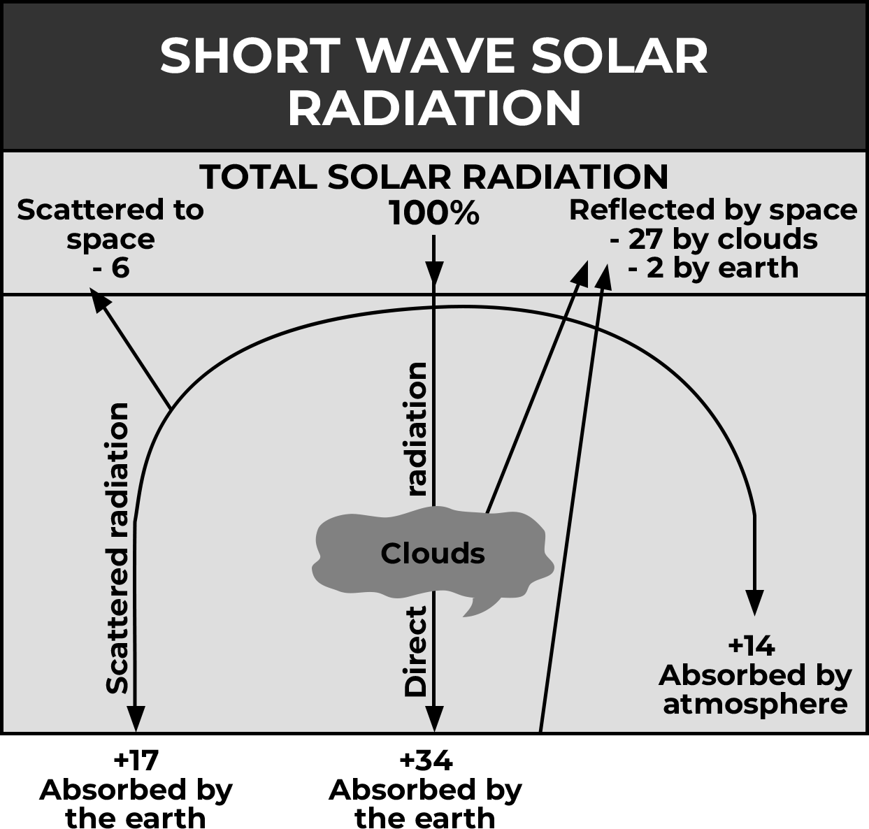
Insolation: The Earth receives a total of 100 units of insolation from the Sun at the top of the atmosphere.
Reflection: Approximately 35 units (35%) of this insolation is reflected back into space before reaching the Earth’s surface. This includes:
• 27 units reflected from the top of clouds.
• 2 units reflected from snow and ice-covered areas.
• 6 units reflected by the atmospheric layer itself.
Absorption: The remaining 65 units (65%) are absorbed, with:
• 14 units absorbed within the atmosphere.
• 51 units absorbed by the Earth’s surface.
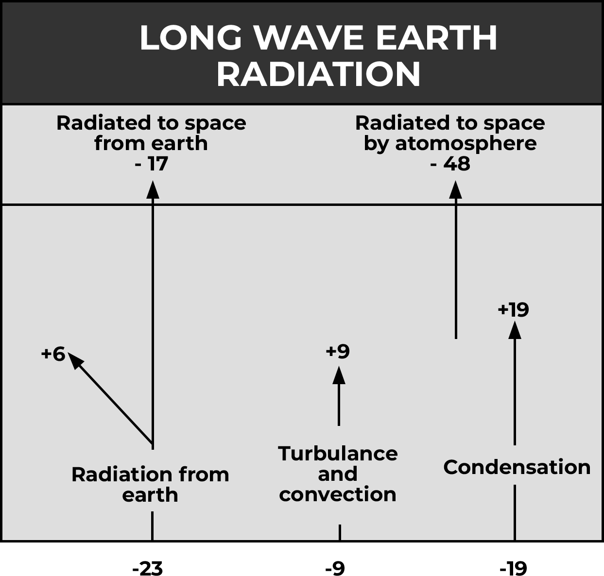
Terrestrial Radiation: The Earth radiates back 51 units of heat in the form of terrestrial radiation.
17 units are radiated directly to space.
The remaining 34 units are absorbed by the atmosphere. Radiation from Atmosphere: The atmosphere also radiates heat back into space, totaling 48 units:
14 units from absorption of insolation.
34 units from absorption of terrestrial radiation.
The total radiation returning from the Earth and the atmosphere is 17 + 48 = 65 units, which balances the 65 units received from the Sun. This equilibrium maintains the Earth’s temperature and is termed the heat budget or heat balance of the Earth.
Latitudinal Heat Balance
The amount of solar radiation received by the Earth varies across different latitudes, creating imbalances in heat distribution:
• Latitude Variation: Solar radiation decreases from the equator towards the poles. Below 40 latitude, more solar radiation is received than is lost to space by the Earth, creating a surplus of heat. Conversely, at higher latitudes, more heat is lost than received, resulting in a deficit of heat.
• Creation of Winds and Ocean Currents: These imbalances in heat distribution led to the formation of winds and ocean currents, which act as vehicles for transporting heat energy from lower to higher latitudes. Most of the heat transfer occurs across the mid-latitudes (30 to 50 ), where stormy weather is often associated.
• Maintenance of Balance: The transfer of surplus heat from lower latitudes to deficit zones at higher latitudes helps maintain an overall balance over the Earth’s surface. Without this transfer, regions with surplus heat would become excessively hot, while deficit zones would become too cold.
• Role of Winds and Ocean Currents: Ocean currents and winds play crucial roles in transferring heat from surplus to deficit zones. This redistribution of heat helps regulate temperatures across different latitudinal belts.
• Heat Budget Equilibrium: Despite these variations, there exists a balance between incoming solar radiation and outgoing terrestrial radiation. This equilibrium, where the Earth’s temperature remains relatively constant, is known as the heat budget or heat balance.
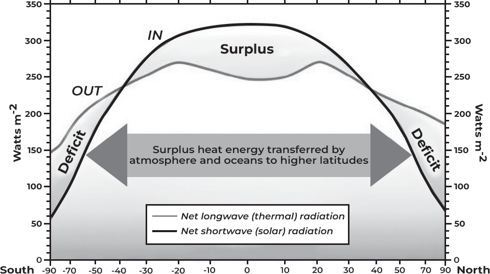
(Fig- Heat surplus and heat deficit zone of the world)
The Mean Annual Temperature Distribution over the Earth
The horizontal or latitudinal distribution of temperature is depicted using a map with isotherms, which are imaginary lines connecting places with equal temperatures, adjusted to sea level to remove altitude effects. Isotherms possess three main characteristics:
• East-West Alignment: Isotherms typically run in an east- west direction, often following parallels (horizontal lines) on a map.
• Bending at Land-Water Boundaries: Isotherms exhibit abrupt bends where there are significant differences in temperatures between land and water.
• Spacing Reflects Thermal Gradient: The spacing between isotherms reflects the latitudinal thermal gradient, indicating the rate of temperature change. Narrow spacing implies rapid temperature changes, while wide spacing suggests gradual changes.
Isotherms closely parallel latitude parallels because locations along the same latitude receive similar amounts of insolation. However, due to differential heating of land and water, temperatures can vary even among places on the same latitude, resulting in deviations from a purely parallel distribution.
General Isothermal Trend
• Temperature Distribution: The highest temperatures occur in the tropics and sub-tropics due to receiving the highest amount of insolation. Conversely, the lowest temperatures occur in continental areas due to continentality. The temperature gradient is wider over tropics and closer over middle and higher latitudes. It’s particularly closely spaced over the eastern margins of continents.
• Irregular Isotherms in Northern Hemisphere: Isotherms are irregular over the Northern Hemisphere due to enhanced land-sea contrast. The prevalence of land over water in the north makes the Northern Hemisphere warmer overall.
• Thermal Equator and Pole-Ward Shift: The thermal equator generally lies north of the geographical equator. When passing through areas with warm ocean currents, isotherms shift pole-ward. This shift is notable over the eastern side of the North Atlantic due to the North Atlantic Drift and Gulf Stream, as well as over the North Pacific due to the Kuroshio Current and North Pacific Current.
• Widening Belt of High Temperature: The belt of high temperature widens over continents. Transitioning from continents to oceans, there’s a distortion in isotherms, particularly pronounced in the Northern Hemisphere. Mountains also impact temperature distribution by blocking oceanic influence, as seen with the Rockies and Andes in North and South America.
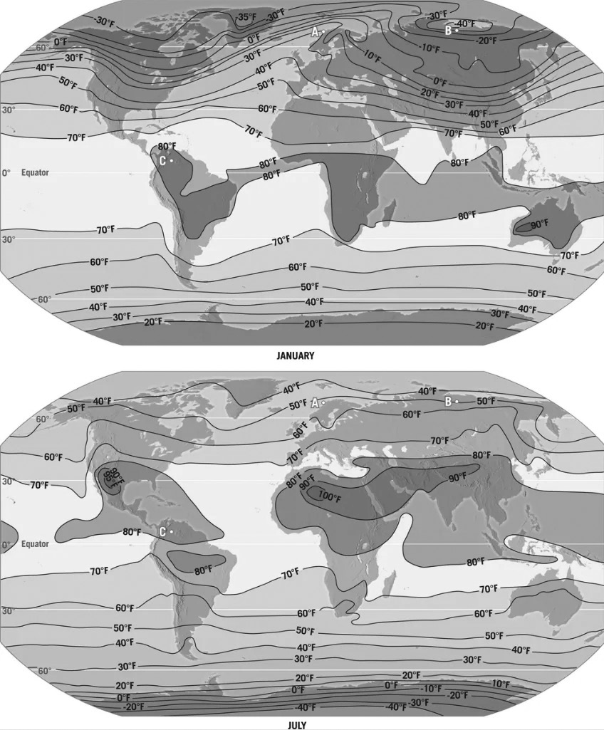
• Seasonal Temperature Patterns: By examining isothermal maps for January and July, changes in global temperature patterns can be studied. These months represent the seasonal extremes for most places on Earth, allowing analysis of temperature variations with respect to the apparent movement of the sun, distribution of land and water, ocean currents and prevailing winds
Seasonal Distribution of Temperature- January
During January, it’s winter in the Northern Hemisphere and summer in the Southern Hemisphere.
Isotherms show specific patterns during this time
• Equatorward Bend Over Northern Continents: Isotherms bend equatorward over northern continents, indicating overcooling of landmasses and penetration of polar cold winds southward.
• Poleward Shift Over Northern Oceans: Isotherms shift poleward over northern oceans, suggesting warmer ocean temperatures able to carry heat poleward.
• Temperature Gradient and Margins: Western margins of continents are warmer than eastern ones due to the Westerlies carrying heat inland. Lowest temperatures are recorded in northern Siberia and Greenland. In the Southern Hemisphere, the high temperature belt lies around 30 S latitude, with the thermal equator positioned south of the geographical equator due to the southward shift of the Intertropical Convergence Zone (ITCZ) with the apparent movement of the sun.
• Temperature Gradient and Margins: The temperature gradient is closer to the eastern margins of continents. For instance, along the east coast of Asia and North America, temperature changes occur at a rate of 1.5 C per degree latitude, while along western margins, it’s 0.5 C per degree latitude. Isotherms behave more regularly in the southern hemisphere during January.
Seasonal Distribution of Temperature— July
During July, it’s summer in the Northern Hemisphere and winter in the Southern Hemisphere. Isothermal behavior in July is opposite to that of January. Specific patterns observed include
Poleward Bend Over Northern Continents: Isotherms bend poleward over northern continents, indicating overheating of landmasses and penetration of hot tropical winds into northern interiors.
Equatorward Shift Over Northern Oceans: Isotherms shift equatorward over northern oceans, suggesting cooler ocean temperatures able to carry moderating effects into tropical interiors. Lowest temperatures are experienced over Greenland.
Temperature Belt and Gradient: The highest temperature belt runs through northern Africa, west Asia, northwest India,
and southeastern USA. Temperature gradient is irregular and zig-zag in the northern hemisphere, becoming regular in the southern hemisphere but showing a slight bend towards the equator at the edges of continents. The thermal equator lies to the north of the geographical equator during July.
Adiabatic Heating and Cooling
Adiabatic change refers to the temperature change that occurs with changes in pressure, particularly as air moves vertically through the atmosphere. When air descends through the atmosphere, it experiences increasing pressure, causing compression. This compression leads to warming, and since the air remains dry, it results in dry and warm conditions in the low.
Conversely, when air ascends, it encounters decreasing pressure, causing expansion. This expansion leads to a decrease in temperature, and any moisture present in the air may condense, releasing latent heat in the process. This phenomenon is responsible for the formation of clouds and precipitation in the atmosphere
TEMPERATURE INVERSION
Under specific conditions, an anomaly to the typical temperature decrease with elevation, known as the normal lapse rate or environmental lapse rate, can occur. This anomaly involves a situation where the temperature in the lower layers of the atmosphere increases instead of decreasing with altitude. This phenomenon commonly occurs along sloping surfaces.
• In this scenario, the surface radiates heat back into space at a rapid rate, causing it to cool down more quickly than the upper layers of the atmosphere. As a consequence, the lower layers of air become cooler and denser, leading to their condensation and increased weight.
Temperature inversion refers to a meteorological phenomenon where the normal vertical distribution of temperature in the atmosphere is reversed. Typically, as you ascend in the atmosphere, the temperature decreases. However, under certain conditions, such as in intermontane valleys or near sloping surfaces, the temperature may increase with altitude instead.
• In this scenario, the sloping surface beneath causes the colder air to move downwards, settling as a layer of cold air near the surface, while the upper layers remain relatively warmer. This results in an inversion of the typical temperature profile, with colder temperatures near the surface and warmer temperatures aloft. Temperature inversions can have significant impacts on local weather conditions and air quality.
Temperature inversion occurs under specific atmospheric conditions that create a reversal of the normal vertical temperature gradient:
Long nights: Temperature inversion often occurs during long nights when the outgoing radiation from the Earth’s surface exceeds the incoming radiation from the Sun.
Clear skies: Clear skies facilitate efficient radiation of heat from the Earth’s surface into space. Without cloud cover or other obstructions, outgoing radiation can escape freely, leading to enhanced cooling at the surface.
Calm and stable air: Temperature inversion is favored by calm and stable air conditions, particularly near the surface. When air near the surface remains undisturbed by vertical mixing, colder air can accumulate and settle beneath warmer air layers, resulting in the inversion of the typical temperature profile.
Types of Temperature Inversion
Air Drainage Type of Inversion: This inversion occurs in valleys where cold, dense air collects and flows downhill, settling at the bottom of the valley. As a result, the valley floor experiences colder temperatures compared to the warmer upper layers.
Surface Temperature Inversion: This common type of inversion occurs on flat surfaces, especially during clear, calm and dry conditions with long winter nights. Rapid heat loss from the surface leads to a temperature inversion, which is relatively shallow and dissipates as the sun rises.
Advectional Type of Temperature Inversion: This inversion occurs when different air masses with varying temperatures meet. The colder, denser air mass settles beneath the warmer, lighter air mass, leading to temperature inversion. This type of inversion is unstable and dissipates with changes in weather patterns.
Upper Surface Temperature Inversion: Massive upper air layers descend and exert pressure on the layers below, causing the upper layers to warm and settle over colder layers, resulting in temperature inversion. This type of inversion contributes to stable atmospheric conditions, especially in dry mid-latitude continental areas during winter, creating a stable high-pressure system. It occurs in the upper parts of the atmosphere and persists for longer durations.
Economic Implications of Temperature Inversion
• Frost Damage: Temperature inversion can lead to frost formation at the bottom of valleys while higher altitudes remain warmer. This temperature discrepancy can result in frost damage to vegetation, particularly trees along the lower slopes, impacting agricultural productivity. Additionally, the inversion can trap air pollutants like dust particles and smoke in the valley bottoms, affecting air quality and potentially causing health issues.
Settlement Patterns: In response to temperature inversion, settlements and agricultural activities in intermontane valleys often occur along the upper slopes rather than in the colder and foggy valley bottoms. For example mulberry planters in the Suwa basin of Japan, coffee growers in Brazil, and apple growers and hoteliers in the mountainous regions of the Himalayas in India tend to avoid lower slopes to mitigate the adverse effects of temperature inversion. This strategic settlement pattern helps protect crops and livelihoods from frost damage and ensures better air quality for residents.
Vertical Distribution of Temperature
The normal lapse rate refers to the consistent decrease in temperature with increasing altitude within the troposphere, which is uniform across latitudes. As one ascends through the troposphere, the temperature typically decreases at a certain rate until reaching the tropopause, where the temperature stabilizes and the lapse rate becomes zero.
In the lower stratosphere, the lapse rate may remain relatively constant for a certain height above the tropopause. However, higher temperatures are observed over the poles in this layer compared to equatorial regions. This temperature variation is attributed to the fact that the lower stratosphere is closer to the Earth’s surface at the poles due to the curvature of the Earth, leading to relatively warmer temperatures in those regions
Temperature Anomaly
• Temperature anomaly refers to the variation between the average temperature of a location and the average temperature of its corresponding latitude. It indicates a deviation from the expected or normal temperature.
• This difference in temperatu re along a latitude is influenced by various factors such as altitude, land- water distribution, prevailing winds, and ocean currents.
• In general, the largest temperature anomalies are observed in the northern hemisphere, while the southern hemisphere tends to have smaller anomalies. A temperature anomaly is considered negative when the temperature at a location is lower than the expected temperature for its latitude, and positive when it is higher.
• Across a year, negative temperature anomalies are typically observed over continental regions from approximately 40 latitude towards the poles, while positive anomalies are more common towards the equator. Conversely, over oceanic areas, positive anomalies are predominant poleward from around 40 latitude, with negative anomalies more common towards the equator
URBAN HEAT ISLANDS
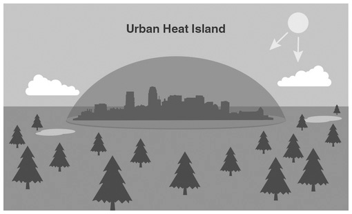
Urban Heat Islands (UHIs) are areas within urban environments that experience higher temperatures compared to their surrounding rural areas due to human activities. These temperature differences are particularly noticeable at night and during periods of light wind. UHIs are most pronounced during the summer and winter seasons.
Several factors contribute to the formation of Urban Heat
Islands (UHIs)
Dark Surfaces: Surfaces like roads, pavements, and building roofs, which are darker in color, absorb more solar heat and radiation compared to lighter surfaces like vegetation and water bodies.
Tall Buildings: The presence of tall buildings in urban areas can contribute to trapping heat, further exacerbating the UHI effect.
Human Activities: Waste heat generated from vehicles, air conditioning systems, and industrial activities also contributes to the elevation of temperatures in urban areas, intensifying the UHI phenomenon.
Urban Heat Islands (UHIs) can have several negative impacts on human health and the environment
Higher Temperatures: UHIs contribute to elevated daytime temperatures and reduced nighttime cooling in urban areas.
Increased Air Pollution: UHIs are associated with higher levels of air pollution due to factors like increased vehicle emissions and industrial activities.
Health Risks: Elevated temperatures in UHIs can lead to heat-related illnesses and even fatalities, including heat cramps, heat exhaustion, and heat stroke.
Damage to Vegetation and Ecosystems: The elevated temperatures in UHIs can harm vegetation and disrupt ecosystems, affecting biodiversity and ecological balance.
Water Resource Management: UHIs can complicate water resource management in cities by increasing water demand for cooling purposes and altering precipitation
patterns, leading to challenges in water supply and management.
Mitigating the effects of Urban Heat Islands (UHIs) can be
achieved through various measures
• Increasing Vegetation: Planting trees and vegetation helps provide shade, which reduces the amount of heat absorbed by buildings and streets.
• Using Lighter-colored Surfaces: Light-colored surfaces, like white roofs and pavements, reflect more sunlight and absorb less heat compared to darker surfaces, helping to lower temperatures.
Reducing Waste Heat: Implementing energy-efficient appliances and vehicles helps reduce waste heat emissions, while reducing overall energy consumption for heating and cooling buildings helps mitigate heat generation.
Improving Ventilation: Creating more green spaces like parks and open areas allows for better air circulation, while designing buildings with features that enhance airflow helps dissipate heat and cool the environment