Tropical Cyclone
TROPICAL CYCLONE
Cyclones are low-pressure systems that develop over warm waters. As warm air rises over these regions, it creates a low-pressure area at the surface. On the other hand, in colder areas, air descends, leading to high pressure at the surface.
In regions of low pressure, such as depressions, air rises and circulates counterclockwise in the northern hemisphere and clockwise in the southern hemisphere due to the Coriolis effect, caused by the Earth’s rotation. As warm, moist air rises, it cools and condenses, forming clouds that can lead to precipitation, including rain.
Major characteristics include
The tropics experience hot and humid weather primarily because the Earth receives more solar radiation than it re-radiates back to space. This excess heating creates a climate that can influence weather patterns globally. The energy imbalance resulting from this drives atmospheric circulation.
These are warm-core low-pressure systems that form over tropical or subtropical waters. Unlike some other weather systems, tropical cyclones lack distinct “fronts” and instead have organized circulation patterns. They are characterized by intense winds and heavy rainfall and they can have significant impacts on regions they affect.
formation. This distance allows for the Coriolis effect to influence the cyclone’s rotation, which is crucial for its development.
• A pre-existing disturbance, such as a tropical wave or an area of low pressure, serves as the initial focus for cyclone development. These disturbances provide the trigger for further organization and intensification of the cyclone.
• Vertical wind shear, which is the change in wind speed and direction with height, should be relatively low (less than about 23 mph or 37 km/h) between the surface and the upper troposphere. Low wind shear allows for the vertical development of the cyclone, enabling it to maintain its structure and strengthen efficiently.
Characteristics of tropical cyclone formation basins
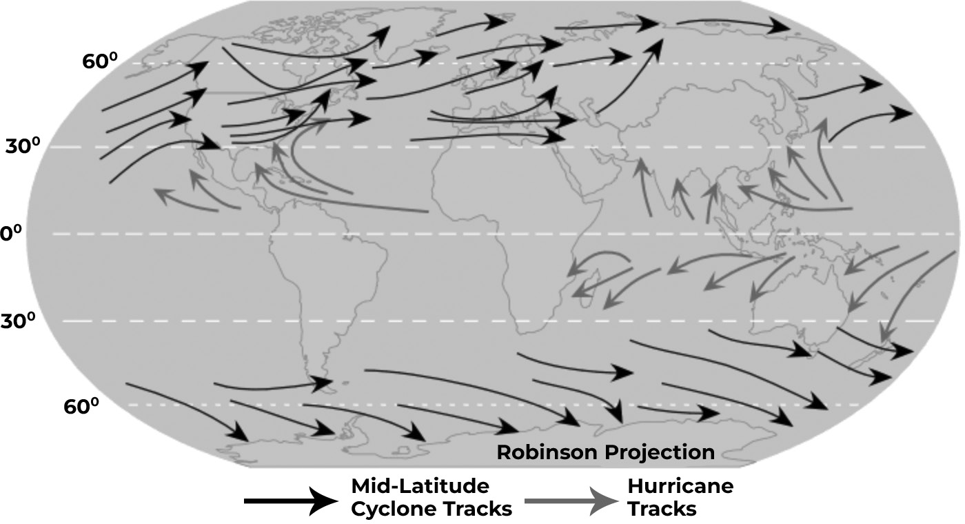
Tropical cyclones typically form in regions near the equator where sea surface temperatures are at least 80 F (27 C). However, they rarely form within 5 latitude of the equator.
The lack of sufficient Coriolis force near the equator inhibits the formation of tropical cyclones within this narrow belt. The Coriolis force is essential for cyclones to develop their characteristic spinning motion.
Despite the restriction near the equator, there are seven regions around the world where tropical cyclones are likely to form. These regions typically have warm ocean waters, favorable atmospheric conditions and sufficient Coriolis force to support cyclone development.
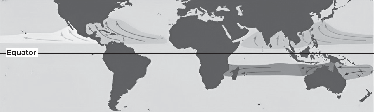
(Fig- Regions of tropical cyclone)
Favorable breeding grounds for tropical cyclones, along with the commonly used names for these storms in different ocean regions:
North Atlantic (including Caribbean and Gulf of Mexico): Tropical cyclones in this region are commonly known as hurricanes.
Eastern and Central North Pacific: Tropical cyclones that form in this area are also referred to as hurricanes.
Western Northern Pacific: Tropical cyclones in this part of the world are known as typhoons.
Arabian Sea/Northern Indian Ocean: Tropical cyclones forming in this region are simply referred to as tropical cyclones.
South Indian Ocean: Tropical cyclones in this area are also known as tropical cyclones. In southwest Australia, they are sometimes called Willy-Willy.
Coral Sea/South Pacific: Tropical cyclones forming in this region are known as tropical cyclones.
Tropical cyclones formation
Tropical cyclones originate from clusters of thunderstorms that persist in areas of low pressure over warm tropical oceans. If these conditions persist and the cluster begins to rotate, it can develop into a tropical cyclone.
Once formed, a tropical cyclone acts like a massive atmospheric heat engine. Moisture from the warm ocean serves as fuel, generating vast amounts of energy as clouds form and the storm intensifies.
The rotating thunderstorms within the cyclone organize into spiral rainbands surrounding the central eye. The eye is characterized by clear skies and light winds, typically around 40 km wide but varying in size. The eye wall, surrounding the eye, contains the strongest winds and heaviest rain.
The rotating thunderstorms transport heat high into the atmosphere, while drier, cooler air at the top serves as the exhaust of the heat engine. Some of this cool air sinks into the low-pressure center, creating the calm eye, while the rest spirals outward, sinking between rainbands.
As long as environmental conditions support the cyclone’s heat engine mechanism, it can maintain its structure and even strengthen over several days.
Tropical cyclones pose significant dangers due to their extreme winds, heavy rainfall leading to flooding, and
storm surge, which can inundate low-lying coastal areas.
The severity of tropical cyclones is classified into categories ranging from 1 (weakest) to 5 (strongest), based on the maximum mean wind speed.
TROPICAL CYCLONE STRUCTURE
The primary components of a tropical cyclone include the rainbands, the eye, and the eyewall. In the northern hemisphere, air spirals inward toward the center of the cyclone in a counterclockwise pattern (clockwise in the southern hemisphere), while air moves upward and outward at the top of the cyclone in the opposite direction.
Eye of a Cyclone
The eye is located at the very center of the cyclone, where air sinks, creating a mostly cloud-free area. It is a circular region with relatively light winds and fair-weather conditions. While winds are calm at the center, strong winds may still extend into the eye.
Within the eye, there is typically little or no precipitation, and sometimes clear skies or stars can be observed.
The eye has the lowest surface pressure and warmest temperatures aloft within the cyclone. The temperature within the eye can be significantly warmer at higher altitudes compared to the surrounding environment. However, at the surface, the temperature difference is minimal, often only slightly warmer than the surrounding areas.
Eyes can vary in size from 8 km to over 200 km across, with most falling within the range of 30-60 km in diameter. The eye is surrounded by the eyewall, which is a ring of deep convection and the area of highest surface winds in the cyclone.
The air within the eye is characterized by slow sinking motion, while the eyewall experiences a net upward flow due to numerous updrafts and downdrafts. The warm temperatures in the eye result from compressional warming of the subsiding air. Soundings taken within the
eye typically show a relatively moist low-level layer with an inversion above, indicating that sinking air in the eye usually does not reach the ocean surface.
The calm eye of a tropical cyclone shares qualitative characteristics with other rotating fluid flows, such as tornadoes, waterspouts, dust devils, and whirlpools. These features are fundamental to many rotating fluid phenomena.
Eyewall of a Cyclone
The eyewall forms due to the convergence of air in a shallow layer near the sea surface, typically between 500 meters to 1 kilometer deep. This layer is known as the boundary layer or friction layer.
Above the boundary layer, the swirling winds within the eyewall are approximately in gradient wind balance. This means that the inward-directed pressure gradient force (which drives air toward the center of the cyclone) is balanced by the sum of the outward-directed centrifugal force (which pushes air away from the center due to rotation) and the Coriolis force (caused by the Earth’s rotation).
Frictional stresses within the boundary layer reduce the tangential wind speed, thereby reducing the centrifugal and Coriolis forces acting on the air. However, the pressure gradient force remains largely unchanged. Consequently, there is a net inward force within this layer, which leads to convergence of air toward the center of the cyclone.
Spiral Bands of a Cyclone
Convection in tropical cyclones is organized into long, narrow rainbands that spiral into the center of the cyclone. These are commonly referred to as “spiral bands.”
Along these spiral bands, low-level convergence is maximized, leading to pronounced upper-level divergence above. This creates a direct circulation pattern, where warm, moist air converges at the surface, ascends through the bands, diverges aloft and descends on both sides of the bands.
As the air descends on the outside of the rainbands, adiabatic warming occurs, causing the air to dry. Subsidence is distributed over a wide area on the outside of the rainband but is concentrated in a smaller area on the inside.
Due to the concentration of subsidence on the inside of the rainband, adiabatic warming is stronger inward from the band, creating a sharp contrast in pressure falls across the band. This pressure contrast increases the tangential winds around the tropical cyclone due to the increased pressure gradient.
Eventually, the rainband moves toward the center of the
cyclone and encircles it. As the pressure falls on the inside of the band, the eye and eyewall of the cyclone form.
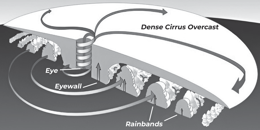
(Fig-Parts of a cyclone)
NAMING OF CYCLONE
Tropical cyclones can persist for a week or longer, and it’s possible to have more than one cyclone active simultaneously. To avoid confusion, each cyclone is given a name by weather forecasters.
Atlantic and Southern Hemisphere (Indian Ocean and South Pacific): Tropical cyclones in these regions are named alphabetically. Names alternate between male and female names. For example, the first cyclone of the season might be named “Alice,” followed by “Bob,” “Clara,” and so on.
Northern Indian Ocean: Since 2000, nations in this region have adopted a new naming system. Cyclones are named alphabetically by country, and the names are gender- neutral. For instance, cyclones might be named “Amara” (from India), followed by “Bobby” (from Bangladesh), “Chitra” (from Sri Lanka), and so forth.
These naming conventions serve practical purposes, helping to communicate about and track individual cyclones more efficiently, particularly when multiple storms are active simultaneously.
Northern Indian Ocean Names - Arabian Sea and the Bay of Bengal:
The naming process for tropical cyclones in the Bay of Bengal and Arabian Sea was agreed upon by the WMO/ ESCAP Panel on Tropical Cyclones during its twenty- seventh Session in 2000.
The naming of tropical cyclones in the Northern Indian Ocean began in September 2004, with names provided by eight initial member countries. Since then, five additional countries have joined the Panel.
The names provided by Panel Members are listed alphabetically by country. These names are then used sequentially, column-wise, starting from the first row of column one and continuing sequentially to the last row in column thirteen.
Once a name is used for a tropical cyclone in the Northern Indian Ocean, it will not be repeated. Once a name is utilized, it will cease to be used again in the future. New names are chosen to ensure a diverse and extensive list. Additionally, the selected names should not be present in the existing lists of any Regional Specialized Meteorological Centers (RSMCs) worldwide, including RSMC New Delhi.
If a tropical cyclone originates in the South China Sea, crosses Thailand, and emerges into the Bay of Bengal, its name will not be changed. The name assigned to the cyclone will remain consistent throughout its trajectory.
Warning and Stages of Tropical Cyclone Pre-Disaster – Cyclones
Four stages of cyclone warnings issued by the Indian Meteorological Department (IMD)
Pre-Cyclone Watch (First Stage Warning): Issued 72 hours in advance, this warning provides early information about the development of a cyclonic disturbance and its potential intensification into a tropical cyclone.
Cyclone Alert (Second Stage Warning): Issued at least 48 hours in advance, this alert includes details about the location and intensity of the storm, its likely movement direction, potential intensification, coastal districts expected to be affected by adverse weather, and advice for fishermen, the general public, media and disaster managers.
Cyclone Warning (Third Stage Warning): Issued at least 24 hours before adverse weather is expected to commence over coastal areas, this warning provides updates every 3 hours. It includes the latest position and intensity of the cyclone, forecasts the landfall point, predicts associated
heavy rainfall, strong winds, storm surge and their impacts. It also provides advice for the general public, media, fishermen and disaster managers.
Post Landfall Outlook (Fourth Stage Warning): Issued at least 12 hours before the expected time of landfall, this warning outlines the likely direction of movement of the cyclone after landfall and the adverse weather expected in interior areas.
These warnings are crucial for preparedness and mitigation efforts, allowing authorities and the public to take necessary actions to minimize the impact of cyclones on lives and property. They provide vital information about the cyclone’s development, intensity, movement and potential impacts, enabling timely evacuation and other preventive measures.
Different colour codes are used in the cyclone warning bulletins.
| Stage of warning | Colour code |
| No Warning | Green |
| Cyclone Watch | Yellow |
| Cyclone Alert | Orange |
| Cyclone Warning | Red |
Post Disaster Operations-Cyclones
Damage Assessment: It is essential to assess the damage caused by the cyclone, including identifying missing persons, fatalities, injuries and damage to properties, livestock, crops and agricultural lands. This assessment helps in providing appropriate relief measures.
Debris Removal and Infrastructure Restoration: Clearing debris, fallen trees and restoring power lines and basic infrastructure require significant effort and may necessitate the mobilization of extra manpower.
Disposal of Dead Bodies and Carcasses: Teams must be organized urgently to dispose of dead bodies and animal carcasses, particularly in areas with high casualties.
Disposal of Spoiled Food: Spoiled foodstuffs dumped on roads need to be disposed of to prevent health hazards.
Air Dropping of Relief Supplies: Inaccessible areas
affected by the cyclone and heavy rainfall may require air dropping of food and essential commodities by the district administration.
Food and Shelter: Food arrangements, including cooked or dry food, must be provided at shelters for affected individuals. Adequate clothing and blankets should also be supplied to ensure dignity safety, and well-being.
Special Attention to Vulnerable Groups: Special attention should be given to vulnerable groups such as children, the elderly, sick individuals, women and widows, who may require additional warm and inner clothing.
Road Restoration: Immediate restoration of roads to a motor-able condition is essential for facilitating relief efforts and access to affected areas.
Mobilization of Earthmoving Machinery: Earthmoving machinery such as JCBs and tractors should be mobilized to aid in clearing debris and restoring infrastructure.