Whatsapp 88106-52225 For Details
Get Free IAS Booklet
Get Free IAS Booklet
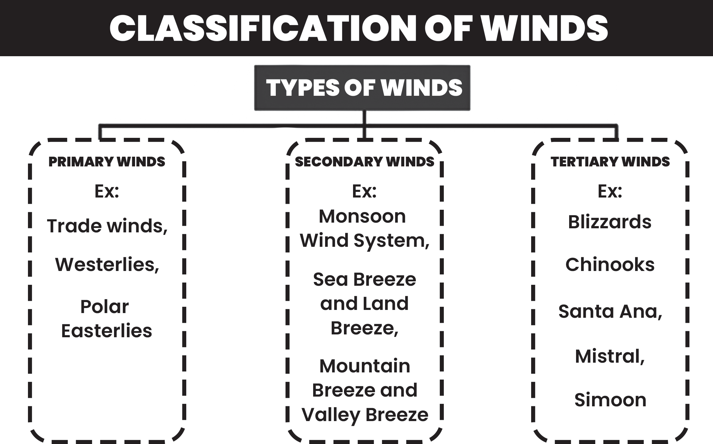
The term “wind” refers to the movement of air from regions of high atmospheric pressure to areas of low pressure. This movement occurs due to pressure differentials created by variations in temperature and atmospheric conditions across different locations on Earth’s surface. Winds can be classified into three main types based on various factors such as their persistence, seasonal patterns, and localized influences:
Primary Winds (Prevailing or Planetary Winds)
These are winds that blow constantly throughout the year in specific directions. They are influenced by global atmospheric circulation patterns and Earth’s rotation. Primary winds include:
Local Winds
Originating due to temperature and/or pressure differences in localized areas, local winds typically blow over short distances and are influenced by local geographic features. Examples include: chinook, Mistral and Simoom .
The direction and speed of wind are influenced by three primary forces
Pressure Gradient Force
This force is akin to a slingshot effect, pulling air from regions of high pressure towards areas of low pressure.
• The greater the difference in pressure between two points, the stronger the force and the faster the resulting winds.
• It essentially drives the air flow from regions of high
atmospheric pressure to regions of low pressure.
Frictional Force:
• Acting like a brake, the frictional force slows down the movement of air as it comes into contact with the Earth’s surface.
• Friction between the air and the surface is more pronounced over land surfaces compared to Over the sea surface the friction is minimal.
• Consequently, winds experience greater resistance and slower speeds when passing over land, while they can move more freely and faster over water.
Coriolis Force:
• This force is a result of the Earth’s rotation and causes the deflection of moving air masses.
• In the Northern Hemisphere, the Coriolis force deflects winds to the right, while in the Southern Hemisphere, it deflects winds to the left.
• Polar Easterlies
• Westerlies (Mid-latitude)
• Trade Winds (Tropics)
Secondary Winds (Periodic or Seasonal Winds)
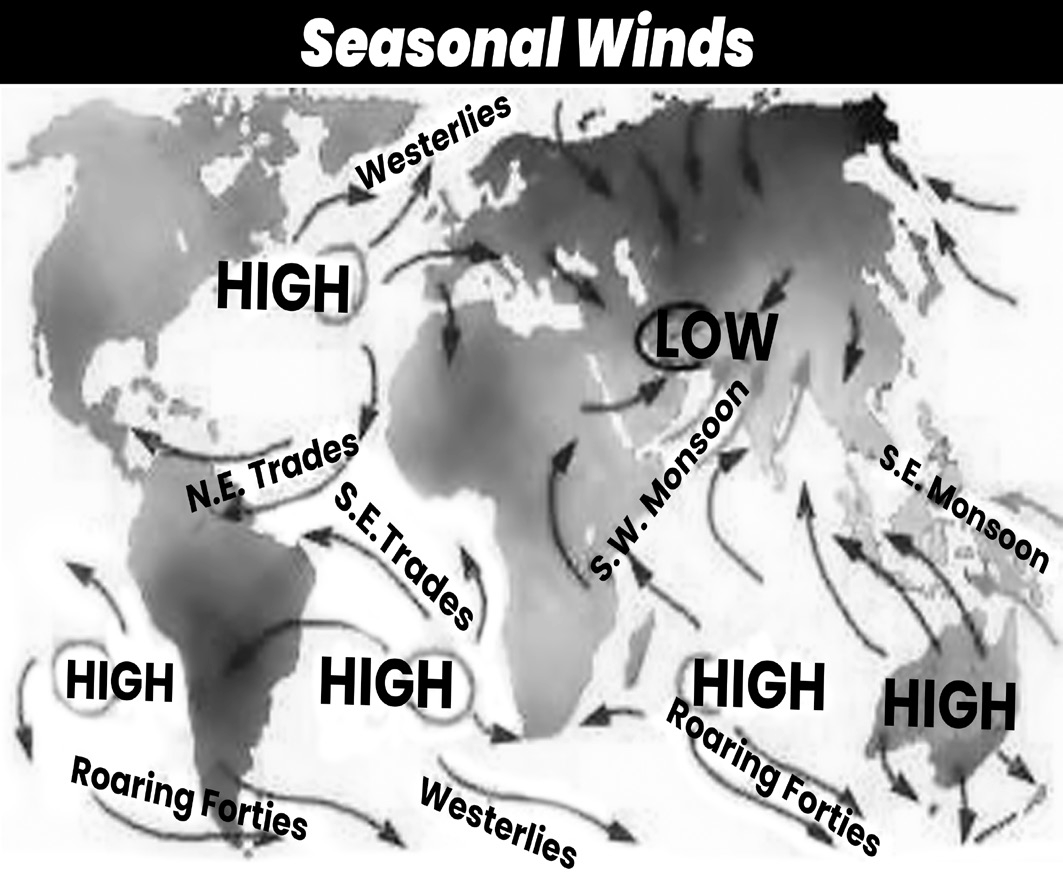
These winds change their direction or intensity with the change of seasons. They are often associated with regional climatic patterns. An example is the monsoon winds in India, which bring heavy rainfall during the summer months and dry conditions in the winter.
PRIMARY WINDS
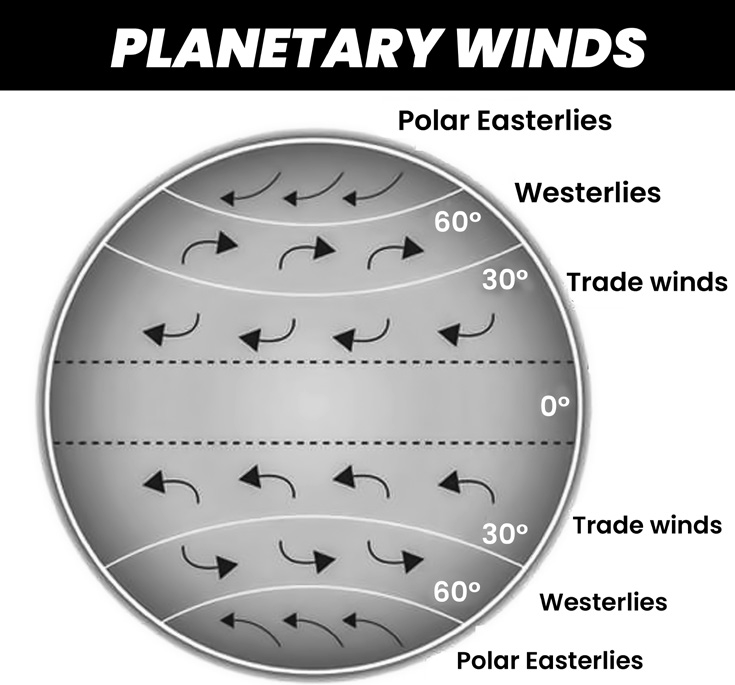
(Fig- Pattern of wind blow; Trade, Westerlies and Polar wind)
Trade Wind
The Trade Winds are a consistent and significant wind pattern that blows from the subtropical high-pressure areas towards the equatorial low-pressure belt.
Note: They don’t blow directly along the pressure gradient but are instead deflected to the right (northeast) in the Northern Hemisphere and to the left (southeast) in the Southern Hemisphere due to the Coriolis force.
Trade Winds are characterized by their regularity in both strength and direction, maintaining a consistent path over long distances. This reliability in their behavior earned them the name “trade winds,” as they were historically
utilized by sailors for trade routes.
These winds flow from cooler subtropical latitudes to warmer tropical latitudes, having a high capacity to hold moisture. As they traverse vast oceanic expanses, they absorb moisture, which is then released as rainfall primarily on the eastern margins of continents.
By the time Trade Winds reach the western margins of continents, they have moved offshore, become heated, expanded, and consequently lost much of their moisture- holding capacity. This phenomenon contributes to the arid conditions found on the western coasts of continents, leading to the formation of deserts in these regions.
Westerlies
Westerlies occur within the Ferrel cell of atmospheric circulation, which is located between 30 and 60 latitude in both hemispheres.
In the Ferrel cell, surface winds move poleward.
The Coriolis force, caused by the Earth’s rotation, deflects air masses to the east (right) in the Northern Hemisphere and to the west (left) in the Southern Hemisphere, resulting in westerly winds.
While westerlies are generally less regular in flow in the Northern Hemisphere due to the presence of landmasses causing disruptions, they blow more strongly in the Southern Hemisphere due to the absence of significant landmasses.
Different terms are associated with specific latitudes in the Southern Hemisphere, such as the Roaring Forties at 40 S, Furious Fifties at 50 S, and Screaming Sixties at 60 S, reflecting the strength and intensity of westerly winds in those regions.
Westerlies bring heavy rainfall to the western margins of temperate zones due to their moisture-laden nature.
The shifting of pressure belts and the apparent movement of the Sun lead to seasonal variations in rainfall distribution. For instance, areas lying between 30 to 40 latitude in both hemispheres receive rainfall primarily in winter from onshore westerlies.
Regions situated on the western margins of continents between 30 to 40 latitude, such as countries around the Mediterranean Sea, Central Chile, southwestern Cape Province and southwestern Australia, experience a Mediterranean type of climate.
These areas receive rainfall mainly in winter from onshore westerlies, leading to a distinct pattern of climate characterized by dry summers and wet winters.
Polar wind
They are prevailing winds, meaning they blow in a consistent direction most of the time.
These winds are easterly, which signifies they travel from east to west.
Their origin is in the frigid regions surrounding the North and South Poles, areas of high atmospheric pressure known as polar highs.
Since cold air sinks and creates high pressure, the polar easterlies carry this cold, dry air outward from the poles.
As they flow outward, they are deflected by the Earth’s rotation (Coriolis effect) and curve slightly southward.
Their destination is the sub-polar regions, areas with lower pressure located just south of the Arctic and Antarctic circles
SECONDARY / PERIODIC WIND
Unlike prevailing winds that blow consistently, periodic winds change direction based on the season.
They occur at specific times of the year, responding to seasonal variations in temperature and pressure.
The most well-known example of a periodic wind is the monsoon wind.
LOCAL WINDS
Local winds are winds that occur due to localized temperature and pressure differences. Examples of local winds include land breeze, sea breeze, mountain breeze and valley breeze.
Land Breeze
• Land breeze occurs during the night when the land cools faster than the sea.
• As the land loses heat, the air above it also cools, leading to higher air pressure over the land compared to the sea.
• Consequently, a breeze blows from the land towards the sea, known as a land breeze.
Sea Breeze
• Sea breeze occurs during the day in coastal areas when the land heats up more rapidly than the sea.
• The warm air above the land rises, creating a low-pressure area over the land.
• The colder, denser air over the sea then moves towards the land to replace the rising warm air, resulting in a breeze blowing from the sea towards the land, known as a sea breeze.
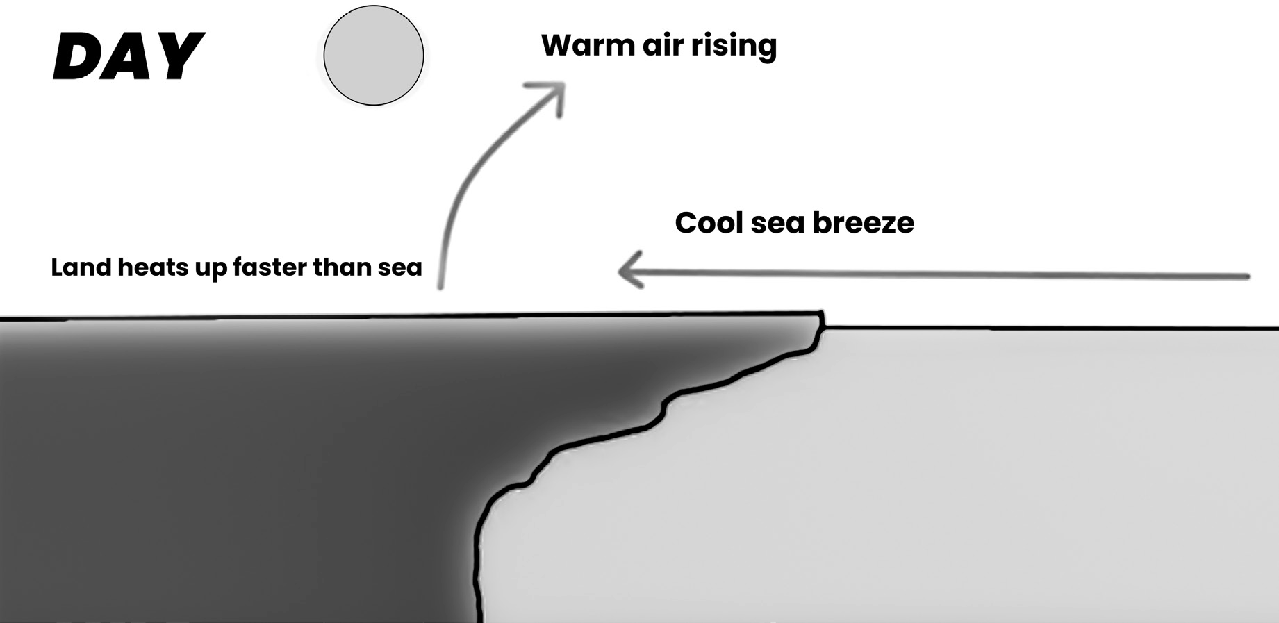
(Fig- Sea Breeze)
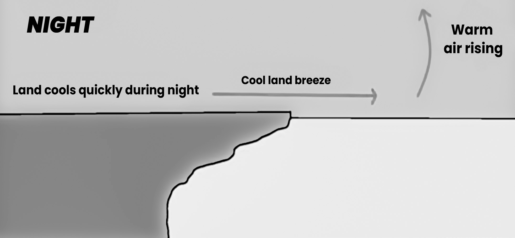
(Fig- land Breeze)
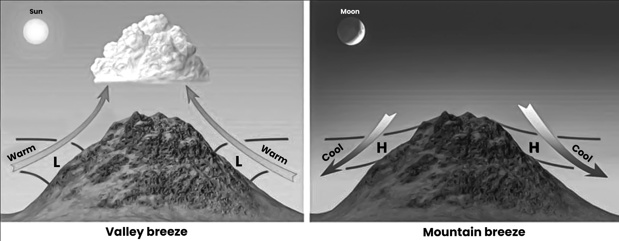
Mountain and valley breeze
Mountain and valley breezes are local winds that occur in mountainous regions due to temperature differences between the slopes and valleys.
Mountain Breeze (Katabatic Wind)
• Mountain breeze occurs during the night when the slopes of mountains cool faster than the surrounding air.
• As a result, the air on the slopes becomes cooler and denser than the air at higher elevations or in the valleys.
•
This denser, cooler air descends downslope, flowing from higher elevations towards the valleys, creating a breeze known as the mountain breeze or katabatic wind.
Valley Breeze (Anabatic Wind)
• Valley breeze occurs during the day when the slopes of mountains are warmer than the surrounding air.
• As the sun heats the slopes, the air near the surface of the slopes becomes warmer and less dense than the air in the valleys.
• This warmer, less dense air ascends upslope, flowing from the valleys towards the higher elevations, creating a breeze known as the valley breeze or anabatic wind.
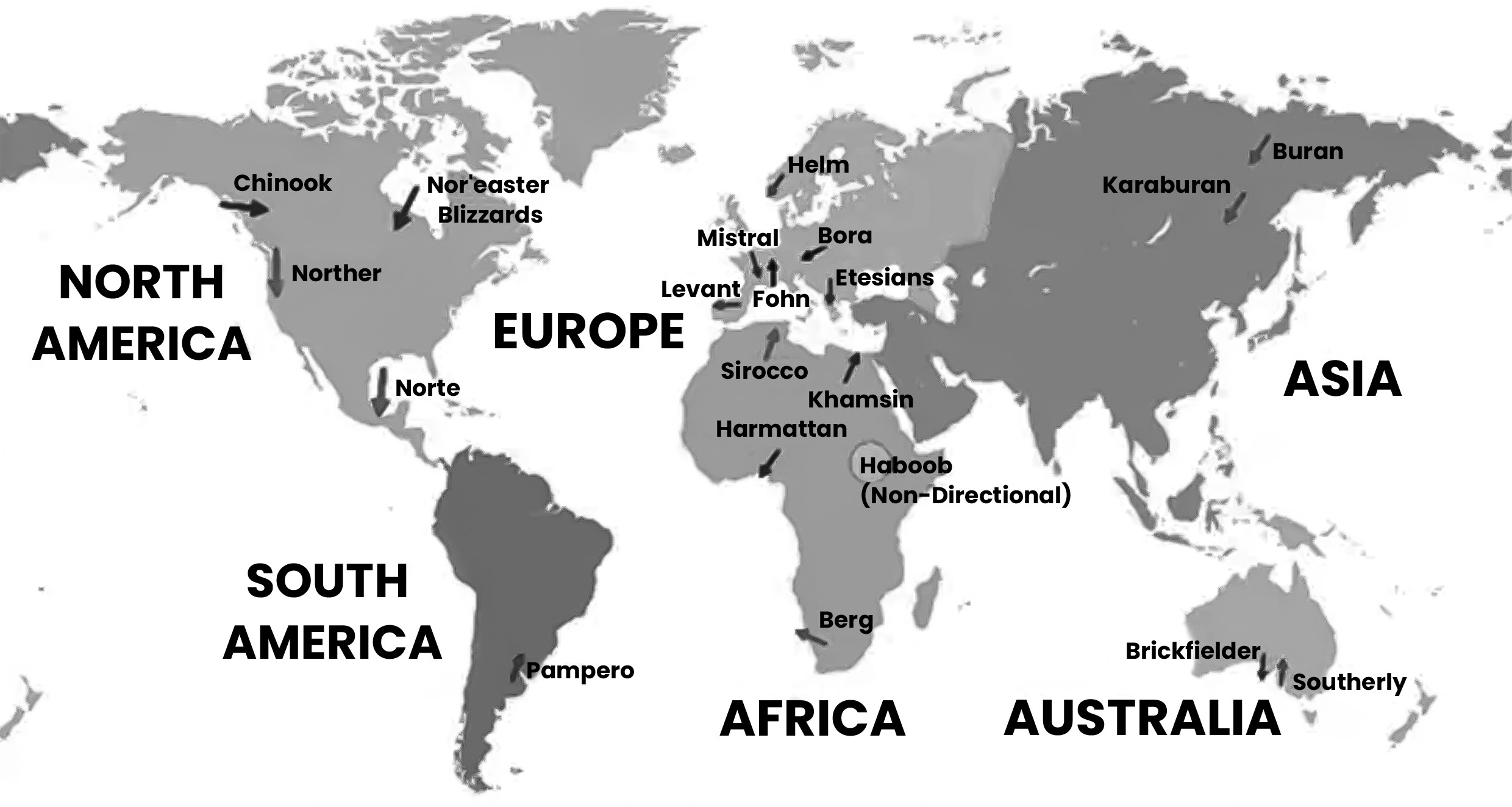
(Fig- Local winds of the world)
Other local winds of the world
Harmattan Wind
• The Harmattan is a strong dry northeast trade wind blowing from the Sahara Desert towards the North- West African coast.
• It occurs from November to mid-March and is characterized by its cool, dry and dust-laden nature.
• The fine desert dust carried by the wind makes the atmosphere hazy and dusty, making aircraft operations and river navigation difficult.
• The Harmattan affects the temperature and humidity, leading to the release of the hot, humid climate of West Africa.
• It is often affectionately called “Doctor” due to its ability to provide relief from the hot and humid conditions.
Foehn/Fohn
• Foehn or Fohn is a strong, dry, dusty and warm wind that blows from the Alps Mountain ranges during the winter season.
• It occurs due to local differential heating, resulting in pressure differences on both sides of the Alps.
• As the wind follows relief lines uphill, it cools adiabatically, leading to rainfall on the windward side of the mountains.
Chinook winds
• Chinook winds are warm, dry westerly winds that blow down the eastern slope of the Rockies into the United States of America and Canada.
• They are also known as “snow eaters” because they help in melting snow earlier.
• Chinook winds are cool and deposit moisture on the windward side of the Rockies.
Sirocco
The Sirocco wind is a hot, dry and dusty wind originating from the Sahara Desert. It typically occurs in the spring season and lasts for a few days. As the Sirocco crosses the Mediterranean Sea, it picks up some moisture, which slightly cools the wind. However, despite this slight cooling effect, the Sirocco remains harmful to vegetation and crops in the regions it affects.
This wind is known by different names in various regions:
• In Spain, it is known as “Leveche.”
• In the Aegean Sea area, it is referred to as “Gharbi.”
• In Egypt, it is known as “Khamsin.”
Loo wind
• Loo is a hot and dry wind prevalent over the northern plains of India and Pakistan, typically occurring in May and June.
• It blows from west to east direction, mostly in the afternoons.
• Loo winds can bring extremely high temperatures ranging between 45 C to 50 C, contributing to heatwaves in the region.
Mistral
• The Mistral is a cold, dry, and high-velocity wind originating from the Alps and moving over to France towards the Mediterranean Sea through the Rhone valley.
• It brings very cold temperatures, sometimes reducing temperatures below freezing point.
• To protect crops and houses from the damaging effects of the Mistral, people in affected areas often plant thick rows of trees and hedges as a shield.
Bora wind
• The Bora wind is a cold, dry, and north-easterly wind
blowing down from the mountains in the Adriatic Sea region.
• It is caused by the pressure difference between continental Europe and the Mediterranean Sea.
• Bora winds usually occur in winter and can reach speeds of over 150 km/h, causing significant disruptions.
Blizzard
• A blizzard is a violent and extremely cold wind laden with dry snow, commonly occurring in Antarctic regions.
• Blizzard conditions are characterized by strong winds with velocities reaching up to 160 km/h and temperatures plummeting as low as -70 C.
Pampero
• The Pampero is a very strong wind that blows in Argentina and Uruguay, particularly in the Rio de la Plata area during the months of June to September.
• It is associated with cold fronts and typically starts with rain, lightning and thunder.
• The Pampero is characterized by a rapid drop in temperature and a sudden change in wind direction from northerly or northwesterly to southerly or southwesterly.
Simoom
• The Simoom is a strong, dry, desert wind that blows in regions such as the Sahara, Israel, Jordan, Syria and the Arabian Desert.
•
It is known for its hot and suffocating nature, often carrying sand and dust.
Southerly
• A “southerly” refers to a storm or a front of air originating from the south.
• In Wellington, New Zealand, southerly storms are brief but intense, bringing strong winds with gusts ranging from 120 km/h to 160 km/h.
• In Australia, particularly in Sydney and Melbourne, similar storms are known as “southerly busters,” which bring sudden and powerful changes in weather conditions, characterized by strong, gusty winds originating from the south.
Santa Ana
• Santa Ana winds are strong and very dry down-slope winds that predominantly occur in autumn and winter.
• Originating from inland areas, they affect northern Baja California and coastal Southern California.
• Santa Ana winds are known for their hot, dry weather, often bringing the hottest temperatures of the year and contributing to the spread of wildfires in affected regions.
• They are colloquially referred to as “devil winds” across Southern California due to their association with extreme fire danger.
IMPORTANCE OF LOCAL WINDS
Local winds play a crucial role in moderating the climate of nearby areas by causing sudden changes in temperature and humidity. However, the extent of this moderating effect depends on the location of the place.
Local winds facilitate the circulation of air, ensuring the availability of oxygen for breathing. This circulation helps maintain air quality and supports ecosystems.
Wind is an essential renewable resource that does not cause direct pollution. Local winds can be harnessed to generate wind energy through turbines, providing a sustainable source of power.
Local winds contribute to the process of precipitation by transporting moisture-laden air over mountains. As this moist air rises and cools, it condenses to form rain and other forms of precipitation, benefiting regions on the windward side of mountains.
Local winds aid in the transportation of various materials such as seeds, pollen grains, sand, and dust from one place to another. This helps in dispersing plant seeds, fertilizing plants, and shaping landscapes.
Winds also play a crucial role in driving ocean surface currents. For example, the Antarctic Circumpolar Current, influenced by wind patterns, transports nutrient-rich water and cold around Antarctica, impacting marine ecosystems and global climate dynamics.
LAPSE RATE
The Lapse Rate is the rate at which temperature changes with height in the Atmosphere. Lapse rate nomenclature is inversely related to the change itself: if the lapse rate is positive, the temperature decreases with height; conversely if negative, the temperature increases with height.
• When air is forced to rise up in the atmosphere, the pressure reduces with height. For a given volume of gas, the pressure divided by the temperature remains constant (Boyle’s Law). Therefore, as the air pressure reduces, so does the temperature.
• If no heat is exchanged with the surrounding air during this process, which is called “adiabatic cooling”, the rate at which the air cools, the Adiabatic Lapse Rate (ALR) is a constant. It has two types: DALR and SALR
• For unsaturated air, the lapse rate is 3 C per 1000 feet; this is called the Dry Adiabatic Lapse Rate (DALR). However, when the parcel of air reaches the Dew Point and becomes saturated, water vapour condenses, latent heat is released during the condensation process, which warms the air, and the lapse rate reduces. The Saturated Adiabatic Lapse Rate (SALR) is therefore the rate at which saturated air cools with height and is, at low levels and latitudes, 1.5 C per thousand feet. At higher altitudes and latitudes, where there is generally less water content in the air, and therefore less latent heat to release, the SALR is closer to 3 C per thousand feet.
• The ELR (Environmental Lapse Rate) is the actual rate at which the ambient temperature changes with height. Considering the parcel of air as before and utilizing the DALR and SALR for that parcel of air in contrast to the surrounding air:
• If the ELR is greater than the DALR, rising air will be warmer than the surrounding air and therefore keep rising; the atmosphere is then said to be unstable. If ELR is greater than SALR, the air is said to be absolutely unstable, since the air, whether saturated or unsaturated, will always have a higher temperature than its surroundings.
When the ELR is less than the DALR and greater than the SALR, then the air is considered conditionally unstable: the condition being whether the air is saturated or not.
If the ELR is less than the DALR, then the rising air will be cooler than the surrounding air and will sink - the atmosphere is said to be stable.
• If the ELR is less than the SALR, the air is said to be absolutely stable, since the air, whether saturated or unsaturated, will always be cooler than the surrounding air.
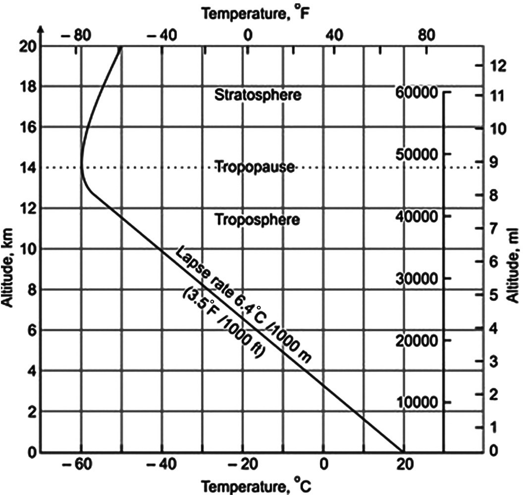
Laps e Rate
• The Earth’s rotation results in the Coriolis force, which deflects moving objects, including air masses, to the right in the Northern Hemisphere and to the left in the Southern Hemisphere. This deflection of wind direction due to the Coriolis force is a significant factor in determining the movement of winds on a global scale, influencing weather patterns and circulation systems.
• Wind movement is primarily driven by the pressure gradient force, which causes air to move from areas of high pressure to areas of low pressure. This pressure difference creates a force that acts like a slingshot, pulling air from regions of higher pressure towards regions of lower pressure, resulting in the movement of wind.
• Below figure shows an air mass moving from high pressure to low pressure under the pressure gradient force in the northern hemisphere.
• When an air mass starts to move, it is deflected to the right (in the Northern Hemisphere) by the Coriolis force, due to the Earth’s rotation.
• The deflection continues until the Coriolis force is balanced by the pressure gradient force, which acts to move air from areas of high pressure to areas of low pressure.
• At this equilibrium point, the wind blows parallel to the isobars (lines connecting points of equal pressure). This wind pattern is referred to as the “geostrophic wind” and represents an idealized situation in the absence of friction.
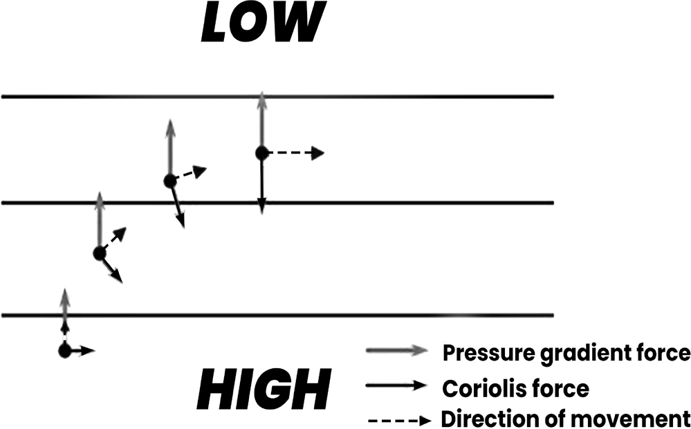
Movemen t of air under Pressure
• In reality, friction between the air and the ground disrupts the ideal geostrophic wind pattern. As a result, the actual wind direction deviates slightly from the geostrophic wind direction, especially over land where friction is higher.
• When the pressure gradient force, frictional force, and Coriolis force are in equilibrium, the wind direction is angled slightly towards the low-pressure side. This slight deviation from the geostrophic wind direction is influenced by the balance between these forces.
•
Frictional effects are smaller over the sea compared to land, allowing geostrophic winds over the ocean to align more closely with actual wind patterns.
GEOSTROPHIC WIND
Key Concepts
• Friction is more pronounced at the Earth’s surface due to interactions with surface features like terrain, vegetation, and buildings. This friction slows down the movement of air near the surface. In contrast, the upper atmosphere experiences less friction, allowing for faster wind speeds. This absence of friction enables the wind to reach its maximum speed at higher altitudes.
• The Earth’s rotation results in the Coriolis force, which deflects moving objects, including air masses, to the right in the Northern Hemisphere and to the left in the Southern Hemisphere. This deflection of wind direction due to the Coriolis force is a significant factor in determining the movement of winds on a global scale, influencing weather patterns and circulation systems.
• Wind movement is primarily driven by the pressure gradient force, which causes air to move from areas of high pressure to areas of low pressure. This pressure difference creates a force that acts like a slingshot, pulling air from regions of higher pressure towards regions of lower pressure, resulting in the movement of wind.
• Below figure shows an air mass moving from high pressure to low pressure under the pressure gradient force in the northern hemisphere.
• When an air mass starts to move, it is deflected to the right (in the Northern Hemisphere) by the Coriolis force, due to the Earth’s rotation.
• The deflection continues until the Coriolis force is balanced by the pressure gradient force, which acts to move air from areas of high pressure to areas of low pressure.
• At this equilibrium point, the wind blows parallel to the isobars (lines connecting points of equal pressure). This wind pattern is referred to as the “geostrophic wind” and represents an idealized situation in the absence of friction.
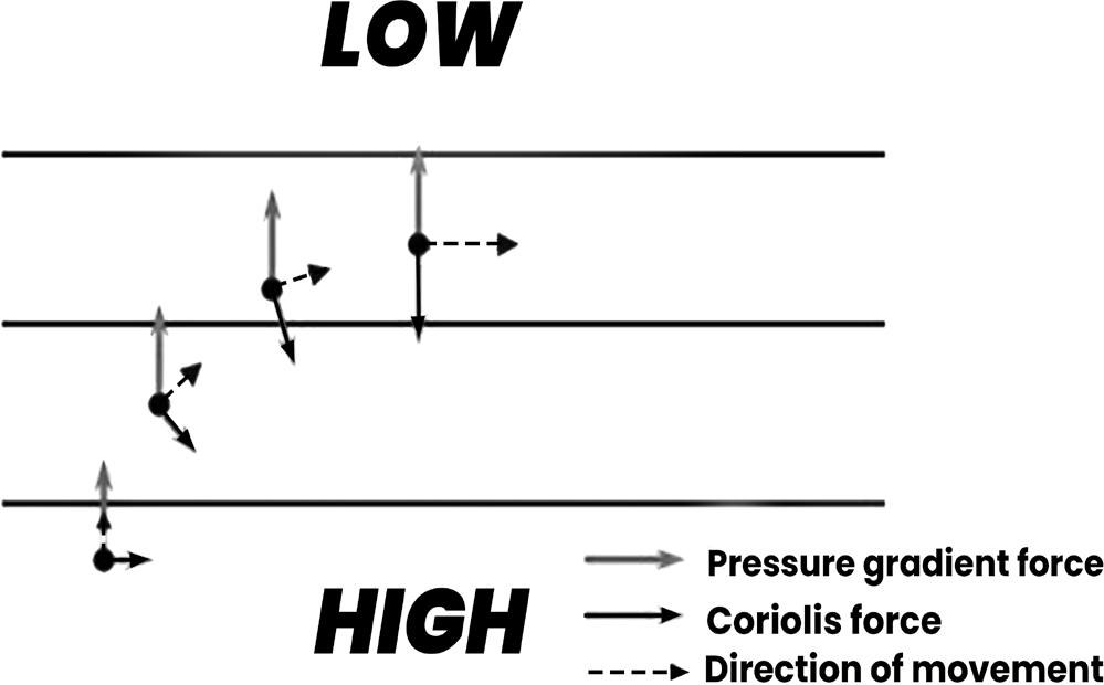
Movemen t of air under Pressure
In reality, friction between the air and the ground disrupts the ideal geostrophic wind pattern. As a result, the actual wind direction deviates slightly from the geostrophic wind direction, especially over land where friction is higher.
When the pressure gradient force, frictional force, and Coriolis force are in equilibrium, the wind direction is angled slightly towards the low-pressure side. This slight deviation from the geostrophic wind direction is influenced by the balance between these forces.
Frictional effects are smaller over the sea compared to land, allowing geostrophic winds over the ocean to align more closely with actual wind patterns.
The Jet Stream
Jet streams are upper-air geostrophic winds found high in the atmosphere, often described as “rivers of air.” They occur in narrow bands at altitudes ranging between 8 to 18 kilometers.
Jet streams are narrow bands of strong, fast-moving air, characterized by minimal friction. They can reach speeds between 120 to 400 kilometers per hour and generally flow from west to east.
Jet streams exhibit meandering patterns, which are known as Rossby waves.
• During World War II, observations were made of air patterns opposing the flight paths of aircraft traveling from the USA to Japan, which led to the identification of jet streams.
• Jet streams play a significant role in influencing weather patterns, air travel routes and various atmospheric phenomena. They follow the boundaries between hot and cold air masses, affecting the movement and behavior of weather systems.
• The Earth has four primary jet streams: two polar jet streams near the north and south poles, and two subtropical jet streams closer to the equator.
• Jet streams are strongest during the winter seasons in both the northern and southern hemispheres, when the boundaries between hot and cold air masses are most pronounced.
Polar and Subtropical Jet Streams
There are two main types of jet streams: polar jet streams and subtropical jet streams. Both the Northern Hemisphere and the Southern Hemisphere have both polar and subtropical branches of the jet stream.
Polar Jet Stream
The polar jet stream is also known as “the jet” or the “mid- latitude jet” because it occurs over the mid-latitudes. It is characterized by strong winds and meandering flow patterns.
The subtropical jet
• The subtropical jet stream exists at around 30 degrees north and south latitudes, in a region known as the subtropics. It forms at the boundary between the temperature differences of air at mid-latitudes and warmer air near the equator.
• Unlike the polar jet stream, the subtropical jet stream is only present during wintertime.
• This is because the temperature contrasts in the subtropics are strongest during winter, allowing for the formation of jet winds.
• The subtropical jet stream tends to be weaker compared to the polar jet stream and is most pronounced over the western Pacific Ocean.
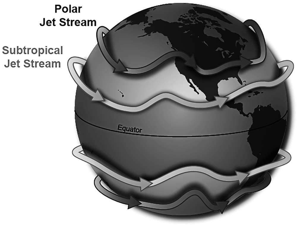
Weather effectivities by the jet streams
• The polar jetstream induces arid conditions in the polar regions due to its thermal direct effect, which results in its permanent existence. During winter, the polar jetstream
extends latitudinally with an intensive pressure gradient, reaching velocities of up to 500 kilometers per hour. It is often referred to as the Polar Night Jet during this
period.
• The Subtropical Westerly Jet (STWJ) contributes to winter precipitation in South West Asia and South Asia, spanning from Iran to India. These wetter conditions are caused by the blocking and transfer of western disturbances originating from the Mediterranean Sea. During the transition to summer, the STWJ shifts northward over
the northern Indian Ocean, leading to the formation of
the tropical easterly jet (TEJ).
• In summer, the northwest shifting of the Intertropical Convergence Zone (ITCZ) displaces the STWJ beyond the Himalayan cordillera. This seasonal shift alters atmospheric circulation patterns and influences weather systems in the affected regions.
• The TEJ plays a crucial role in regulating monsoonal winds, particularly in the maintenance of pressure gradients between the Tibetan low and Mascarene high. This pressure gradient drives distinctive branches of southeast trade winds, contributing to the onset and intensity of the southwest monsoon.