Climate Types and Characteristics
CLIMATE TYPES AND CHARACTERISTICS
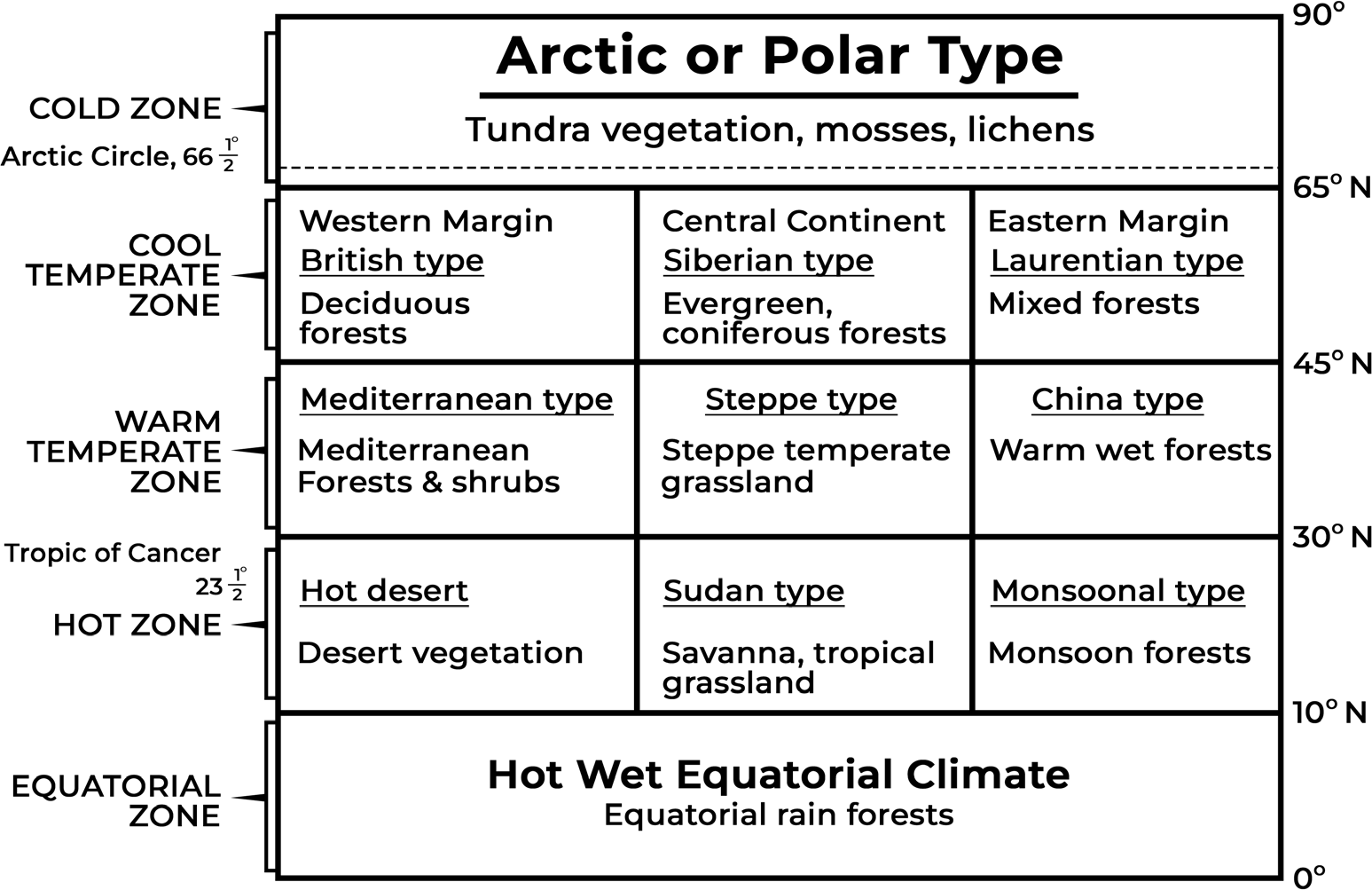
The World Climate types are understood based on their latitudinal extent and continental position. When looked at this way, the climatic regions have similar climate, vegetation and economic practices. These have been classified below-
| The Hot, Wet Equatorial Climate | |||
| Distribution | Climate | Vegetation | Economy |
| It is found between 5º and 10º north and south of the equator. It is dominantly found in the lowlands of the Amazon, the Congo, Malaysia and the East Indies. | There is great uniformity of temperature throughout the year. The mean monthly temperatures are always around 24 to 27ºC, with very little variation. There is no winter. The diurnal and annual range of temperature is small. Precipitation is heavy between 60 inches and 10 inches, and well distributed throughout the year. The double rainfall peaks, coinciding with the equinoxes are characteristics feature of it. | It supports a luxuriant type of vegetation – the tropical rain forest. Amazon tropical rain forest is known as Selvas. It comprises a multitude of evergreen trees that yield tropical hardwood, e.g. mahogany, ebony, greenheart, cabinet wood and dyewoods. Lianas, epiphytic and parasitic plants are also found. Trees of single species are very scarce in such vegetation. | The equatorial regions are generally sparsely populated. In the forests, most primitive people live as hunters and collectors and the more advanced ones practice shifting cultivation.Some plantation crops are also practiced like natural rubber, cocoa, etc. |
| The Tropical Monsoon & Tropical Marine Climates | |||
| Distribution | Climate | Vegetation | Economy |
| It is found in the zones between 5º and 30º latitudes on either side of the equator. It is best developed in the Indian sub-continent, Burma, Thailand, Laos, Cambodia, parts of Vietnam and South China, and northern Australia. TropicalMarine climate is found in Central America, West Indies, the Philippines, parts of East Africa, Madagascar,the Guyana coast and eastern Brazil. | Though the mean annual temperature is fairly high but summer and winter seasons are sharply differentiated due to the northward and southward movement of the sun. The average temperature of warm dry summer months ranges between 27ºC and 32ºC. Most of their annual rainfall occurs through cyclonic and orographic types of rains. The average annual rainfall is around 150 cm but there are many variations in the temporal and spatial distribution. Most of the annual monsoonalrainfall is received through moisture-laden South- West monsoon winds. | Treesarenormally deciduous. The forests are open and less luxuriant. Most of the forests yield valuable timber like teak. Other kinds of timber are sal, acacia, and eucalyptus. | Peoplearemainly engaged in agriculture. Agri-cropsarerice, cane sugar, jute, etc. |
| The Savanna or Sudan climate | |||
| Distribution | Climate | Vegetation | Economy |
| It is located between 5 degrees and 20 degrees on either side of the equator. It is a transitional type of climate found between the equatorial forests and the semiarid and subtropical humid climate. The most characteristic areas of savanna climate include the Llanos of Orinoco valley, the Campos of Brazil, hilly areas of Central America,southern Zaire, etc. | The Savanna climate is characterized by distinct wet and dry seasons. Mean high temperature throughout the year is between 24ºC and 27º C. The annual range of temperature is between 3ºC and 8ºC. The extreme diurnal range of temperature is a characteristic of the Sudan type of climate. The average annual rainfall ranges between 100 cm and 150 cm. | It is characterized by tall grass and short trees. Treesaredeciduous and hard. The grass is tall and coarse like elephant grass. Scrubland is well represented by a number of species in Australia like mallee, mulga, Spinifex grass, etc. | Many tribes live within the Savanna lands. Some tribes live as pastoralists like the Masai and others as settled cultivators like the Hausa of northern Nigeria. However, agriculture is not much developed. |
| The Hot Desert and Mid-latitude Desert Climates | |||
| Distribution | Climate | Vegetation | Economy |
| Deserts are regions of scanty rainfall which may be hot like the Saharan type or temperate as are the mid-latitude deserts like the Gobi. The major hot deserts of the world are located on the western coasts of continents between latitudes 15º and 30ºN and S. Some other hot deserts are the Great AustralianDesert, Arabian Desert, Iranian Desert. Thar Desert, Kalahari and Namib Deserts. In Americas, there is Mohave Desert, Atacama/ Peruvian Desert & the Patagonian Desert. | The hot deserts lie on Sub Tropical High- Pressure Belts where the air is descending, a condition least favorable for precipitation. Rain normally occurs as violent thunderstorms of the convectional type. With high temperatures through-out the year, there is no cold season and the average summer temperature is around 30ºC. | Thepredominant vegetation of both hot and mid-latitude deserts is xerophytic or drought-resistant scrub. This includes the bulbous cacti, thorny bushes, long-rooted wiry grasses, and scattered dwarf acacias. Most desert shrubs have long roots and are well spaced out to gather moisture, and search for groundwater. Plants have few or no leaves and the foliage is either waxy, leathery, hairy or needle- shaped to reduce the loss of water through transpiration. | Bushmen of the KalahariDesert, Tuaregs of the Sahara, Mongols of the Gobi Desert and the Bindibu of Australia are some of the tribes. Theydomesticate various animals like horses, camels, wild dogs and operate as nomadic huntsmen. In arid Atacama, mining of copper is famous. Oil and minerals have been found in Arabian deserts which have brought prosperity. |
| Mediterranean Climate | |||
| Distribution | Climate | Vegetation | Economy |
| Climate prevalent in theMediterranean basin. Prevails in much of California, in parts of Western and South Australia, in southwestern South Africa, and in parts of central Chile. Mediterranean climate zones are associated with the five large subtropicalhigh- pressure cells of the oceans, the Azores High, South Atlantic High, North Pacific High, South Pacific High, and Indian Ocean High | Theclimateis characterized by hot, dry summers and cool, wet winters. These areas are near large bodies of water, temperaturesare generally moderate with a comparatively small range of temperatures between the winter low and summer high. Receivesrainfall primarily during winter as the polar jet stream brings periodic streams. During summers, there are subtropical high- pressure cells causing no rains. | Evergreen trees such as cork oak and eucalyptus, jarrah and karri (in Australia). Evergreen coniferous trees are pines, firs, cedars, and cypresses. Bushes such as myrtle, rosemary, lavender, arbutus, thyme, and laurel. Scrubs are Maquis in southern France, Macchia in Italy, Chaparral in California, mallee in Australia, and Garigue. | Orchard lands known for fruit cultivation, cerealgrowing, wine-makingand agricultural industries as well as engineering and mining. A wide range of citrus fruits such as oranges, lemons, limes, citrons, and grapefruit are grown. |
| The Temperate Continental (Steppe) Climate | |||
| Distribution | Climate | Vegetation | Economy |
| Bordering the deserts, away from the Mediterranean regions and in the interiors of continents. In the northern hemisphere,the grasslands are far more extensive and are entirely continental. In Eurasia, they are called the Steppes. In North America, they are called prairies. In Argentina they are called Pampas. In South Africa they are subdivided into the more tropical Bush- veld in the north, and the more temperate High Veld in the South. | Their climate is continental with extremes of temperature in the Northern Hemisphere. In contrast, in the southern hemisphere it is never severe. The annual precipitation can be expected to be light. The average rainfall may be taken as about 20 inches, but this again varies according to the location from 10 inches to 30 inches. | Scantyvegetation, practically treeless and the grasses are much shorter than Savanna. Where the rainfall is moderate, the grasses are tall, fresh, and nutritious. Where rain is less than 20inches the short steppe type of grass prevails. The steppe grass can lie dormant throughout the prolonged drought. | Home of grazing animals; wild horses in the Asiatic Steppes, bison in the Prairies, and buffaloes in the Pampas. Dominated by nomadic and semi-nomadic peoples like the Kirghiz of the Asiatic Steppes. Some grasslands have been plowed up for extensive, mechanized wheat cultivation and are now the ‘granaries of the world’. Maize is increasingly cultivated in warmer and wetter areas. The tufted grasses have been replaced by the more nutritious Lucerne or alfalfa-grass. |
| The China Type Climate OR Temperate monsoon | |||
| Distribution | Climate | Vegetation | Economy |
| On the eastern margins of continents in warm temperate latitudes, just outside the tropics. Most of China experiences it and it is sometimes referred to as the Gulf type of climate. In the southern hemisphere,this kind of climate is experiencedalong the warm temperate eastern coastlands of all three continents: in New South Wales with its eucalyptus forests; in Natal where cane sugar thrives; and in the maize belt of the Parana-Paraguay- Uruguay basin. | Warm moist summer and a cool, dry winter. The mean monthly temperaturevaries between 40ºF and 78ºF and is strongly modified by maritime influence. The relative humidity is a little high. Rainfall from 25 inches to 60 inches is fairly uniform throughout the year. Rain comes either from convectional sources or as orographic rain in summer or from depressions in prolonged showers in winter. Local storms, e.g. typhoons and hurricanes, also occur. | Haveluxuriant vegetation. The lowlands carry both evergreen broadleaved forests and deciduous trees including oak, camphor, camellia, and magnolia. On the highlands, are various species of conifers such as pines and cypresses which are important softwood. Chestnuts, ironwood, and black woods found. Grass, ferns, lianas, bamboos, palms present. | The Warm Temperate Eastern Margin Climate supports a wide range of crops. Rice, tea, sugarcane, coffee, maize, cotton, tobacco, and mulberries are extensively grown. Farming is usually on a subsistence basis. The Gulf type of climate is undoubtedly the best for cotton growing. |
| The Cool Temperate Continental /Boreal Climate OR Taiga Climate OR Siberian Climate | |||
| Distribution | Climate | Vegetation | Economy |
| Experienced only in the northern hemisphere. On its poleward side, it merges into the Arctic tundra of Canada and Eurasia around the Arctic Circle. Southwards, the climate becomes less severe and fades into the temperate Steppe climate. | A bitterly cold winter of long duration, and cool brief summer. Spring and autumn are merely brief transitional periods. An annual range of 54 F is common in the Siberian type of climate. 15 to 25 inches is typical of the annual precipitation of this sub- Arctic type of climate. It is quite well distributed throughout the year, with a summer maximum from convectional rain. In winter the precipitation is in the form of snow. | The coniferous forest belts of Eurasia and North America are the richest sources of softwood. The world’s greatest softwood producers are USSR, the USA, Canada, and the Fennoscandian countries. There are four major species in coniferous forests. Pine, e.g. white pine, red pine, Scots pine, Jackpine, lodgepole pine. For, e.g. Douglas fir and balsam fir, Spruce and Larch. | The various species of pine, fir larch, and spruce are felled and transported to the sawmills for the extraction of temperate softwoods. There is little agriculture which includes cereals (barley, oats, rye) and root crops (potatoes) raised for local needs. Many of the Samoyeds and Yakuts of Siberia and some Canadians are engaged in hunting, trapping, and fishing. |
| The Cool Temperate Eastern Margin/Laurentian Climate | |||
| Distribution | Climate | Vegetation | Economy |
| It is an intermediate type of climate between the British and the Siberian. It has features of both the maritime and the continental climates. It is found only in two regions (i) north-eastern North America (ii) eastern coastlands of Asia, including eastern Siberia, North China, Manchuria, Korea, and northern Japan. In the southern hemisphere,this climatic type is absent. | Cold, dry winters and warm, wet summers. Winter temperatures may be well below freezing point and snowfalls to quite a depth. Summers are as warm, as the tropics (70º- 80ºF). Though rain falls throughout the year, there is a distinct summer. Of the annual precipitation of 30 to 60 inches, two-thirds come in the summer. | Cool temperate forest with coniferous north of the 50ºN parallel of latitude. In Asia the forest is a continuation of the great coniferous belt of the taiga. South of latitude 50ºN, the coniferous forests give way to deciduous forests. Oak, beech, maple and birch are the principal trees. | Lumbering and its associatedtimber, paper, and pulp industries are the most important economic undertaking. Agriculture is less important in view of the severity of the winter and its long duration.Potatoes thrive over large areas of the podzolized soils, while hardy cereals like oats and barley can be sown and successfully harvested before the onset of the cold winter. Other crops include soya beans groundnuts, sesame, rapeseeds, tung oil, and mulberry. Farmers are engaged in dairy farming, hay cultivation, and in mild maritime areas, fruit growing. |
| The Arctic or Polar Climate/Tundra Climate/Polar Climate/Arctic Climate | |||
| Distribution | Climate | Vegetation | Economy |
| Found mainly north of the Arctic Circle in the northern hemisphere. The ice-caps are confined to Greenland and to the highlands of these high-latitude regions, where the ground is permanently snow-covered. | Very low mean annual temperature and its warmest month in June with temperature up to 50 F. Winters are long and very severe; summers are cool and brief. North Pole has six months without light in winter. Frost and blizzards, reaching 130m/h are common Precipitation is mainly in the form of snow, falling in winter. Convectional rainfall is generally absent because of the low rate of evaporation and the lack of moisture in the cold polar air. | In such an adverse environment as the tundra, few plants survive. The greatest inhibiting factor is the region’s deficiency in heat. There are no trees in the tundra. Such an environment can support only the lowest form of vegetation, mosses, lichens, and sedges. | The few people who live in the tundra live semi-nomadic life. In Greenland, northern Canada, and Alaska live the Eskimos. During winter they live in compact igloos and in summer when they move out to hunt, they pitch portable tents of skins by the side of the stream. Their food is derived from fish, seals, walruses, and polar bears. In the Eurasian tundra are other nomadic tribes such as the Lapps of northern Finland and Scandinavia, the Samoyeds of Siberia, Yakuts,Koryaks, and Chukchi of northeastern Asia. |
| British Type of Climate/North-West European Maritime Climate | |||
| Distribution | Climate | Vegetation | Economy |
| The cool temperate western margins are under the influence of the Westerlies all-round the year. They are the regions of frontal cyclonic activity [Temperate Cyclones]. This type of climate is typical to Britain, hence the name ‘British Type’. Also called as North-West European MaritimeClimate due to greater oceanic influence. | The mean annual temperatures are usually between 40 F and 60 F, thus giving an annual temperature range of only 24 F. The British type of climate has adequate rainfall throughout the year with a tendency towards a slight winter or autumn maximum from cyclonic sources. Since the rain-bearing winds come from the west, the western margins have the heaviest rainfall. The amount decreases eastwardswith increasing distance from the sea. | The natural vegetation of this climate type is deciduous forest including oak, elm, ash, birch, beech, poplar, and hornbeam. In the wetter areas grow willows, alder, and aspen. Elsewhere are found chestnut, sycamore, maple, and lime. Thedeciduous hardwoods are excellent for both fuel and industrial purposes. In Tasmania, the temperate eucalypts are also extensively felled for the lumbering industry. | Deciduous woodlands have been cleared for fuel from timber. Fishing is particularly important in Britain, Norway, and British Columbia. Innorth-western, Europeintensive market gardening is carried out. Tasmania is nicknamed the ‘garden state’ in Australia. Farmers practice both arable farming and pastoral farming. Mixed farms with wheat cultivation, cattle and sheep rearing |
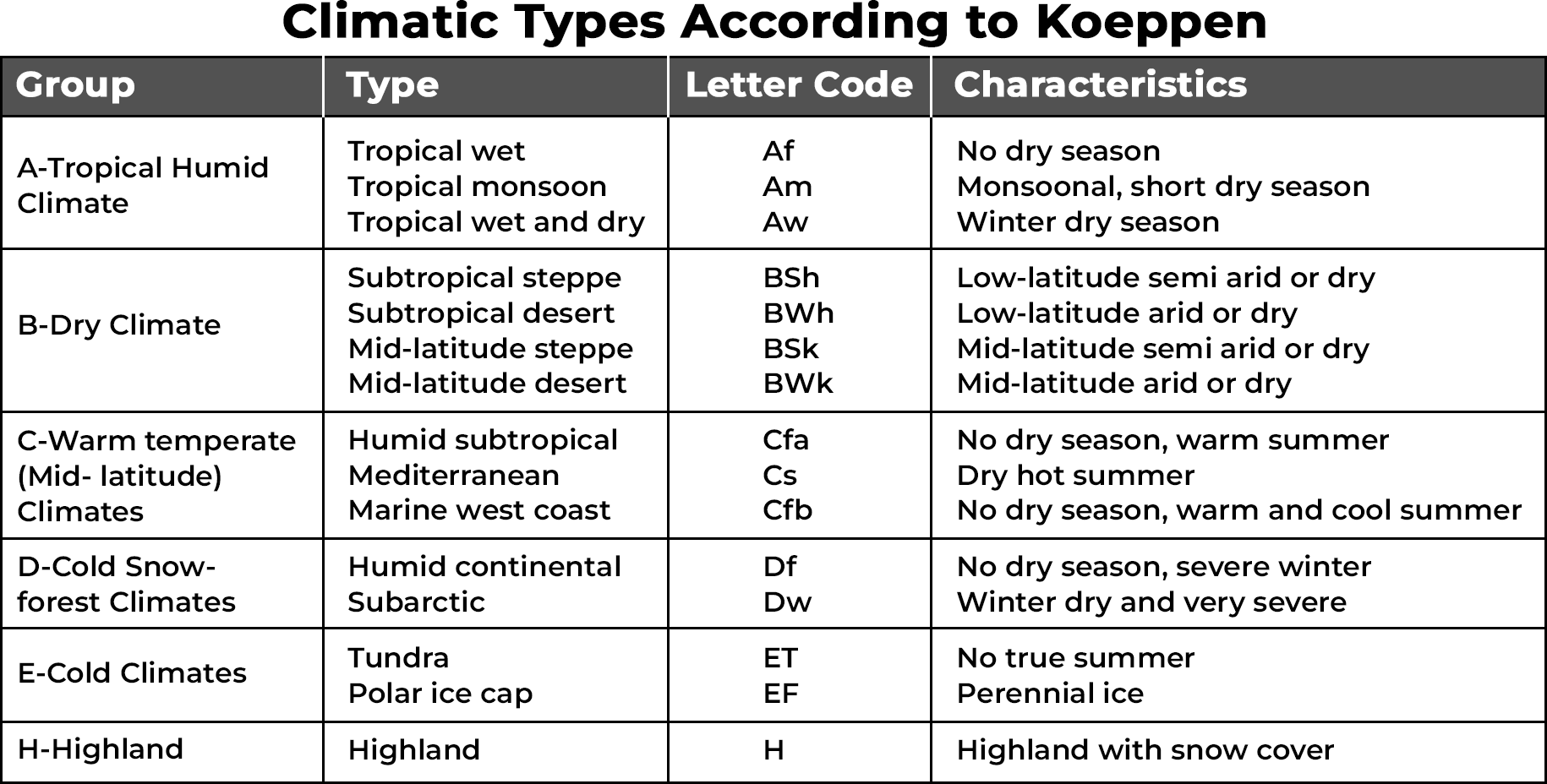
KÖPPEN’S SCHEME OF CLASSIFICATION OF CLIMATE
Modern climate classification methods are categorized into two main approaches: genetic methods and empiric methods.
Genetic Methods: These methods focus on the underlying causes of climate. They often consider factors such as the origin and characteristics of air masses, synoptic weather patterns, and other atmospheric dynamics. Examples of genetic classification methods include:
Analyzing the relative frequency of different air mass types.
Examining the locations within synoptic weather disturbances.
Empiric Methods: These methods emphasize the observable effects of climate, such as temperature, precipitation, and vegetation patterns. Examples of empiric classification methods include: Climate zones defined by factors like plant hardiness, evaporation, and transpiration.
The Köppen climate classification system, developed by climatologist Wladimir Köppen in 1901, which categorizes climates based on mean annual and mean monthly temperature and precipitation data.
Köppen’s classification is an example of an empirical classification method. It relates temperature and precipitation values to the distribution of vegetation, recognizing the close relationship between climate and vegetation patterns. By identifying specific temperature and precipitation thresholds associated with different vegetation types, Köppen created a classification system that is widely used for understanding and categorizing climatic regions around the world.