Landslides
Landslides, Land Subsidence and Avalanches
• Landslides refer to the downward movement of rocks, debris, or soil along mountain slopes or riverbanks.
• These movements can be gradual, but sudden and unexpected sliding may also occur.
•
Landslides often coincide with natural disasters such as earthquakes, floods, and volcanic eruptions.
• In some cases, prolonged heavy rainfall triggers significant landslides that obstruct river flow for an extended period. When these blockages give way, they can cause severe destruction to downstream settlements.
• Landslides occur due to gravitational force, leading to both downward and outward displacement of slope materials.
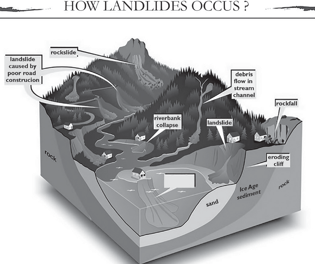
• India's hilly regions, particularly the Himalayas and the Western Ghats, are highly susceptible to landslides.
• The Himalayan mountain range consists of young, geologically unstable formations, often resulting in massive landslides, such as the Malpa landslide of 1998.
• On the other hand, the Western Ghats and Nilgiri Hills are geologically stable but have elevated plateau edges influenced by neotectonic activity. Landslides in these regions are typically surface- level events that do not disturb the bedrock but occur mostly during monsoons, impacting the densely populated areas more severely.
• It is estimated that the Himalayan region accounts for 30% of the world's landslides. In the Nilgiris, heavy rainfall in 1978 led to severe landslides. Overall, landslides impact approximately 15% of India's total land area.
• Land Subsidence: It refers to the vertically downward movement or sinking of earth's surface, gradually or suddenly, caused by natural or man-made reasons like removal of water, oil or natural resources, earthquakes, soil erosion, soil compaction etc. e.g. 2023 Joshimath disaster.
• The regional variation in the incidences of landslides at national level can be seen in the following table.
| Region | Incidences of Landslides |
| Himalayas | High to very High |
| North eastern Region | High |
| Western Ghats and Nilgiris | Moderate to High |
| Kerala, Eastern Ghats and Vindhyachal | Low |
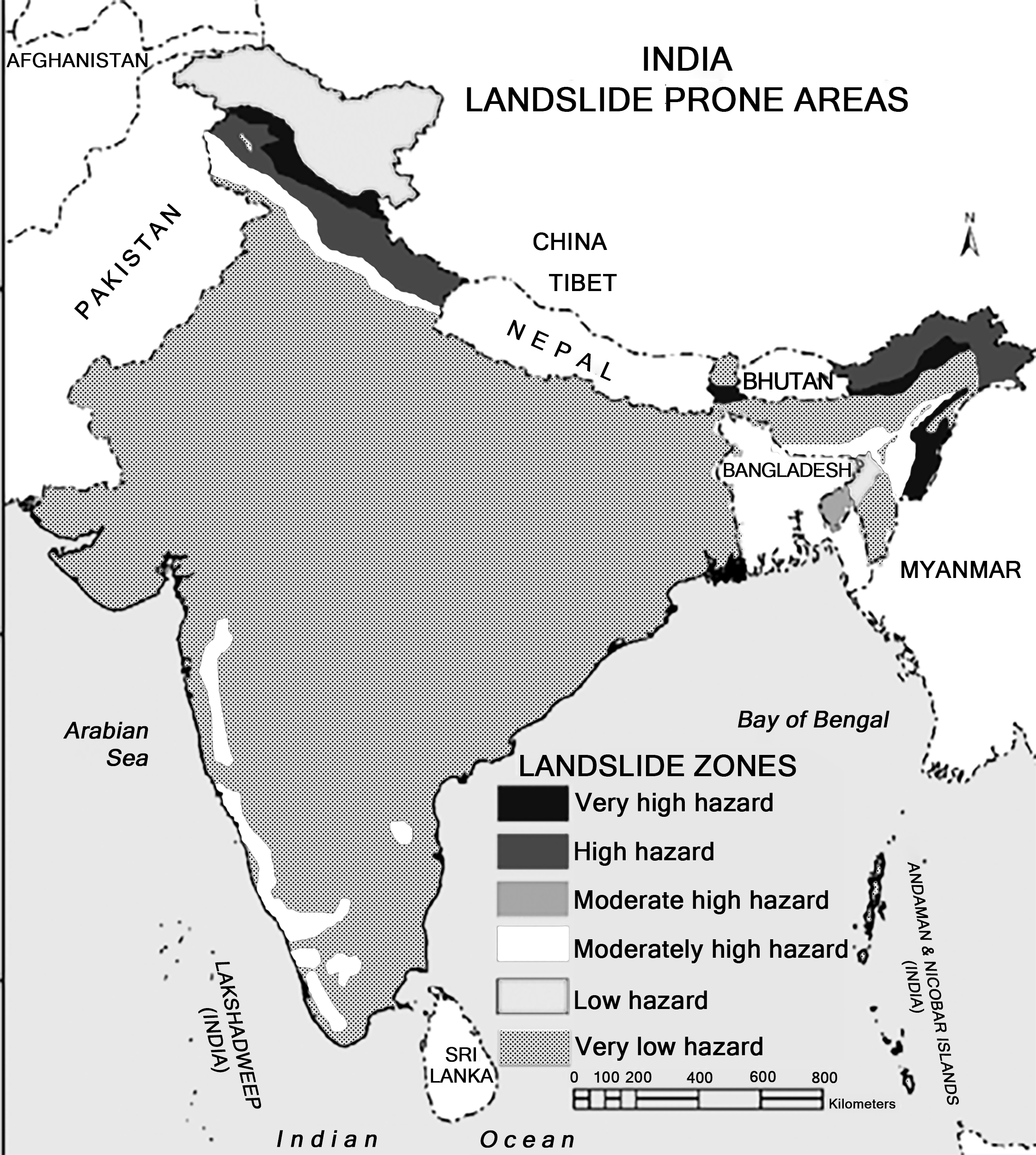
Map: Landslide prone areas of India
Causes of landslides
• Intense Rainfall: One of the primary triggers of landslides is heavy rainfall.
• Loss of Vegetation Cover: Deforestation is another significant factor contributing to landslides. Trees, shrubs and grasses help bind soil particles together, maintaining stability. When trees are cut down, mountain slopes lose their protective layer, allowing rainwater to flow rapidly and uncontrollably, increasing the risk of landslides.
• Seismic Activity and Volcanic Eruptions: Earthquakes are frequent in the Himalayan region, causing tremors that destabilize mountains, leading to rockfalls and landslides. Similarly, volcanic eruptions can trigger landslides in mountainous areas.
• Road Construction: Infrastructure development in mountainous regions often requires road construction, which involves removing large amounts of rock and debris. This process weakens the natural rock structure and alters slope angles, making landslides more likely.
• Shifting Cultivation: In northeastern India, the practice of shifting agriculture has contributed to a rise in both the frequency and intensity of landslides.
• Urbanization and Tourism Development: The growing population and expanding tourism industry have led to increased construction of houses, hotels, and other buildings. The excavation and accumulation of construction debris further destabilize slopes, triggering landslides.
Impact of landslide
• Degrading of environment: Landslides are degrading the environment of mountains. Natural beauty is diminishing slowly and slowly.
• Sources of water are drying up.
• Flooding in rivers is increasing.
• Roads are blocked.
• Life and property are lost.
• The grasses of industrial importance should also be planted so that there is some economic return to the farmers as well.
Use the Surface Vegetative Cover to protect the land from raindrop’s beating action, bind the soil particles and decrease the velocity of flowing water.
Natural Disasters Cyclone
Natural Disasters: Cyclone
Cyclones occur due to atmospheric disturbances around a low-pressure zone, characterized by rapid and often destructive air circulation.
They are typically accompanied by intense storms and severe weather conditions. In the Northern Hemisphere, air moves inward in an anticlockwise direction, whereas in the Southern Hemisphere, it circulates clockwise.
Cyclones are categorized into two types: (i) extra-tropical cyclones, also known as temperate cyclones, and (ii) tropical cyclones.
Tropical cyclones result from interactions between the ocean and atmosphere, fueled by the sea's heat and influenced by easterly trade winds, temperate
westerlies, high planetary winds, and their own powerful energy.
Cyclones forming in the region between the Tropic of Cancer and the Tropic of Capricorn are termed tropical cyclones. These are large-scale weather systems developing over tropical or subtropical waters, leading to organized surface wind circulation.
Extra-tropical cyclones, on the other hand, develop in temperate and high-latitude regions, though some may originate from Polar Regions.
Indian Context
The Indian subcontinent is one of the worst affected regions in the world.
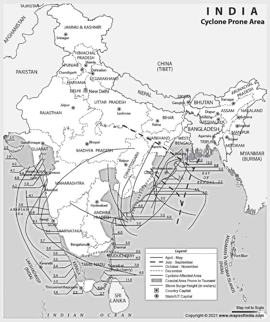
Map : cyclone prone areas in India
• Cyclones typically occur during two distinct seasons: the pre-monsoon period (May–June) and the post- monsoon period (October–November).
Their impact is mainly restricted to coastal districts, with the most severe destruction occurring within 100 km of the cyclone's center and along both sides of its path. The majority of casualties result from coastal flooding caused by tidal waves, storm surges, and heavy rainfall.
The Indian subcontinent, with an extensive coastline of 8,041 kilometers, is vulnerable to approximately 10% of the world’s tropical cyclones.
Around 71% of the cyclone-prone areas are spread across ten states—Gujarat, Maharashtra, Goa, Karnataka, Kerala, Tamil Nadu, Puducherry, Andhra Pradesh, Odisha, and West Bengal. Additionally, the Andaman and Nicobar Islands, as well as Lakshadweep, are also highly susceptible to cyclones.
A significant number of cyclones originate over the Bay of Bengal and primarily impact India's eastern coastline.
•
On average, five to six tropical cyclones form annually, with two to three intensifying into severe storms. The Bay of Bengal experiences more cyclones than the Arabian Sea, with an approximate ratio of 4:1.
Some Do's and Don'ts Before, During and After the Cyclone
• Listen to the radio.
• Keep time for safety.
• When the storm strikes:
• Stay in the house and take shelter in the stronger portion of your house.
• Listen to the radio and follow instructions.
• Open windows of the safe portion of the house if the roof begins to lift.
• Find cyclone shelter if you are in open at the hitting time of the cyclone.
• Do not go out. Cyclone often generates large surges in these oceans or lakes.
• Impact of Cyclones
| Category | Wind speed (Kmph) | Storm surge (metre) | Potential Damage | Action |
| Deep Depression | 50-61 kmph | Minor damage - Minor damage to loose/ unsecured structures and some breaches in Kutcha road due to flooding. Minor damage to Banana trees and coastal agriculture due to salt spray. Damage to ripe paddy crops. Very rough seas with waves about 4-6 m high. Minor damage to kutcha embankments. | Fishermen advised not to venture into sea | |
| Cyclonic storm | 62 -87 kmph | Minor to Moderate damage - Damage to thatched huts. Minor damage to power and communication lines due to collapse of tree branches. Major damage to Kutcha and minor damage to Pucca roads. Some damage to paddy crops, Banana, Papaya trees and orchards. High to very high sea waves about 6-9 m high. Sea water inundation in low lying areas after erosion of Kutcha embankments | Fishermen advised not to venture into sea | |
| Severe cyclonic storm | 88-117 kmph | Up to 1.5 metres | Moderate damage - Major damage to thatched houses / huts. Roof tops may blow off. Unattached metal sheets may fly. Minor damage to power and communication lines. Major damage to Kutcha and some damage to Pucca roads. Flooding of escape routes. Breaking of tree branches, uprooting of large avenue trees. Moderate damage to Banana and Papaya trees. Phenomenal seas with wave heights of 9-14 m. Movement in motor boats unsafe. Major damage to coastal crops. -Storm surge damage to salt pans and embankments. Inundation up to 5 kms in some areas. | Fishermen advised not to venture into sea. Coastal hut dwellers advised to move to safer places. Other people in the affected areas are to remain indoors. |
| Very severe cyclonic storm | 118-167 Kmph | Up to 2 metres | Large Total destruction of thatched houses/ extensive damage to kutcha houses. Some damage to pucca houses. Potential threat from flying objects. Bending/ uprooting of power and communication poles. Major damage to kutcha and pucca roads. Flooding of escape routes. Minor disruption of railways, overhead power lines and signalling systems. Widespread damage to standing crops, plantations and orchards. Uprooting of trees. Phenomenal seas with wave heights of more than 14m. Visibility severely affected. Movement in motor boats and small ships unsafe. Inundation up to 10 Km in specific areas. | Fishermen not to venture into sea. Evacuation from coastal areas needs to be mobilised. People advised to remain indoors. Judicious regulation of rail and road traffic |
| Very severe cyclonic storm | 168-221 kmph | 2 – 5 metres | Extensive - Extensive damage to all types of kutcha houses and some damage to pucca structures. Potential threat from flying objects. Extensive uprooting of power and communication poles. Disruption of rail / road link at several places. Extensive damage to standing crops, plantations and orchards. Blowing down of Palm and Coconut trees. Uprooting of large bushy trees. Phenomenal seas with wave heights of more than 14m. Movement in motor boats and small ships not advisable. Inundation may extend up to 10-15 kms over specific areas. | Fishermen are not to venture into the sea.Evacuation from coastal areas is essential. |
| Super cyclonic storm | Over 222 kmph | Over 5 metres | Catastrophic damage - Extensive damage to non-concrete residential and industrial building. Structural damage to concrete structure. Air full of large projectiles. Power and communication poles uprooted. Total disruption of supply. Extensive damage to kutcha roads and some damage to poorly repaired pucca roads. Large scale submerging of coastal roads due to flooding and sea water inundation. Flooding of escape routes. Major damage to bridges, signals and railway tracks. Total destruction of standing crops / orchards. Uprooting of large trees and stripping of tree barks. Phenomenal wave heights of more than 14 metres. All shipping activity unsafe. Extensive damage to port installations. Inundation up to 40 kms in specific areas and extensive beach erosion. | Fishermen not to venture into the sea. Large scale evacuationsare needed. Rail and road traffic to be totally stopped in vulnerable areas. |
• Cyclones are characterized by their destructive potential to damage structures such as houses, lifeline infrastructure such as power and communication towers, hospitals, food storage facilities, roads, bridges, culverts, crops, etc., due to high velocity winds.
• Exceptionally heavy rainfall causes flooding. Storm surge inundates low-lying areas in the coastal areas resulting in loss of life and destruction of property, besides eroding beaches and embankments, destroying vegetation and reducing soil fertility.
• Such calamity leads to the evacuation and displacement of several marginalised people settled in the coastal areas,
which also has a huge effect on the livestock. Fisheries are also severely affected as the fish ponds are filled with silt and saline water, and their recovery takes time.
• The heavy rainfall also leads to drainage damage, which hampers the water supply and increases water sanitation problems. The drainage damage leads to an increase in the number of water-borne and vector diseases, such as Malaria, Dengue, Filaria and Kala- azar, among others, and the people who have been displaced and moved are unfortunately vulnerable to these diseases.
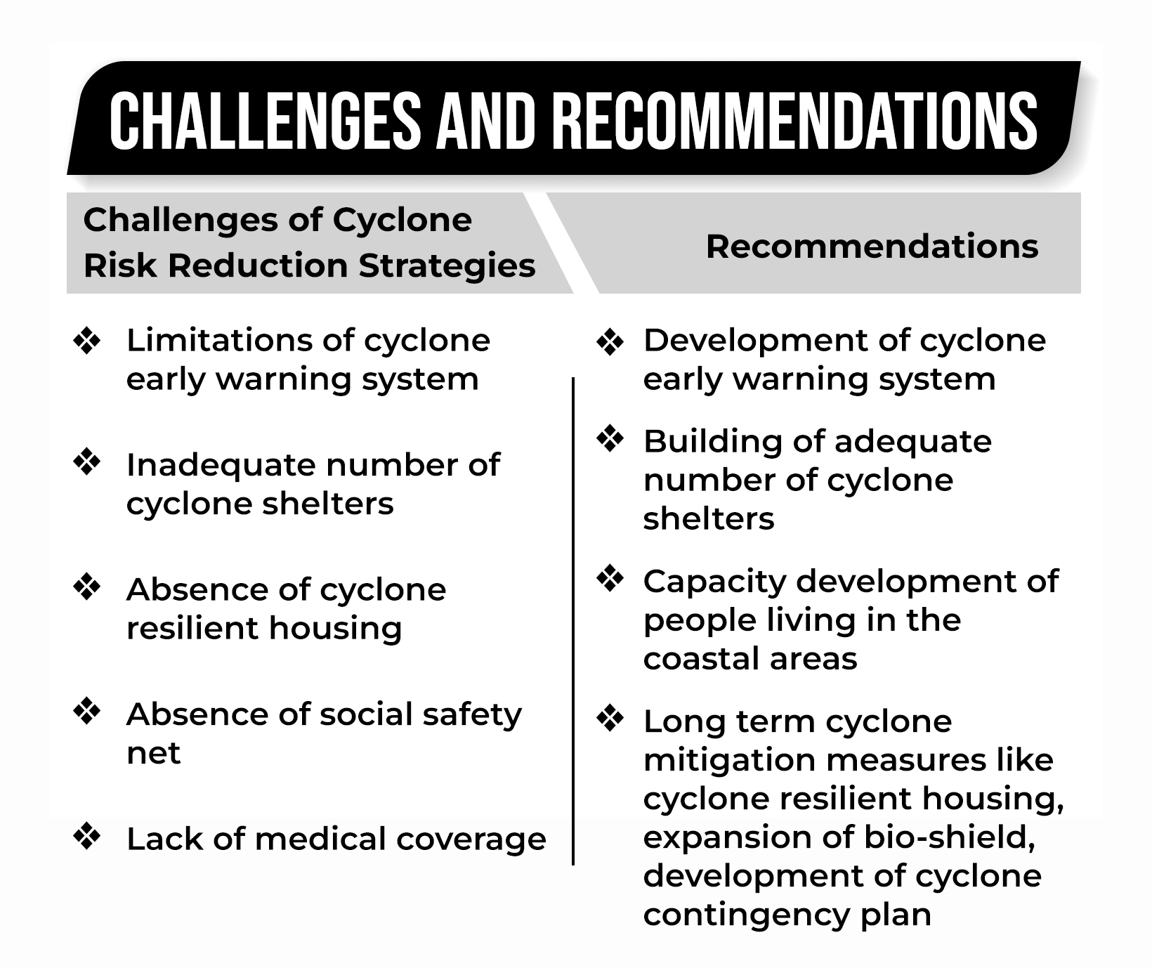
Cyclone Risk Mitigation Strategy
Cyclone Risk Mitigation Strategy Understanding Risk
• Upgrading observation networks, equipment, systems and technology
• Implementing land-and ocean-based observation systems
• Conducting research and studies to enhance forecasting accuracy
• Developing and maintaining a cyclone database for improved predictions
• Carrying out zoning and mapping of cyclone-prone regions
Monitoring coastal areas vulnerable to cyclones
• Conducting hazard risk and vulnerability assessments
• Ensuring effective dissemination of warnings, data, and information
Inter-Agency Coordination: Inter-agency collaboration plays a crucial role in strengthening disaster risk governance. Coordination is necessary between central and state agencies in various areas, including overall disaster management, emergency response, early warnings, information and data exchange, and the implementation of non-structural measures.
Investing in DRR–Structural Measures
• Identifying secure buildings and locations to serve as temporary shelters for evacuated residents and livestock from high-risk areas.
• Constructing multi-purpose cyclone shelters in coastal villages and settlements frequently affected by cyclones.
• Maintaining drainage systems and flood embankments to prevent waterlogging and mitigate flood risks.
•
Ensuring adherence to relevant building codes for disaster-resistant construction.
• Incorporating cyclone-resistant features in the planning and execution of social housing projects.
• Implementing hazard-resistant construction methods, strengthening, and retrofitting critical infrastructure and lifeline structures.
• Cyclone Shelters: In densely populated coastal regions where large-scale evacuations are challenging, public buildings can serve as cyclone shelters. These structures should feature a blank façade with minimal openings facing prevailing winds. The shorter side of the building should be oriented toward the storm to minimize wind resistance.
• Promoting mangrove plantations and flood management initiatives.
• Ensuring the availability of emergency kits containing dry and packaged food.
• Using earth berms and green belts in front of buildings to reduce storm impact.
Investing in DRR–Non-Structural Measures
• Implementing ecologically sustainable land-use zoning while regulating activities such as aquaculture and groundwater extraction.
• Considering shoreline erosion and structural risks while monitoring shoreline changes to preserve natural barriers.
• Designating coastal zones for various purposes in accordance with Coastal Regulation Zone guidelines and the techno-legal framework of town and country planning regulations, ensuring proper enforcement and monitoring.
• Encouraging private sector participation in coastal management initiatives.
Capacity Development
• Conducting training and orientation programs for state government employees and key stakeholders, including civil society members, media professionals, elected representatives, and veterinary professionals, to support disaster-affected animals.
• Integrating disaster response, search and rescue operations into youth training programs, including village volunteers, to enhance the protection of animals impacted by disasters.
• Revising undergraduate engineering curricula to incorporate subjects related to cyclone hazard mitigation.
• Encouraging ministries and all States/UTs to organize and implement emergency drills regularly.
• Advancing skill development initiatives for multi- hazard-resistant construction in cyclone-prone regions, focusing on resilient housing and infrastructure such as wind- and water-resistant buildings, as well as structures on stilts.
• Incorporating gender sensitive and equitable approaches in capacity development covering all aspects of disaster management at the state, district, and local levels.
• Strengthen ability of communities to manage and cope with disasters based on a multi-hazard approach.
• Training for panchayat, SHG, NCC, NSS, youth, local community organizations.
• Awareness Generation:
• Carry out mass media campaigns
• Promote culture of disaster risk prevention, mitigation, and better risk management
• Promote attitude and behaviour change in the awareness campaigns
• Promote use of insurance/ risk transfer
• Promote Community Radio
• Strengthening network of civil society organizations for awareness generation about DRR and DM
Earthquake
Earthquake
An earthquake is a phenomenon that occurs without warning and involves violent shaking of the ground and everything over it. It results from the release of accumulated stress of the moving lithospheric or crustal plates.
The earth’s crust is divided into seven major plates, that are about 50 miles thick, which move slowly and continuously over the earth’s interior and several minor plates.
Earthquakes are tectonic in origin; that is the moving plates are responsible for the occurrence of violent shakes.

Figure: Earthquakes
Indian context:
• Around 59% of India's landmass is prone to earthquakes. The three most recent major earthquakes occurred in Gujarat in January 2001, Jammu and Kashmir in October 2005, and Sikkim in 2011.
The Himalayan Mountain range is the youngest fold mountain system globally and remains highly geologically active. Over the last 53 years, this region has experienced four earthquakes with magnitudes exceeding 8 on the Richter scale.
The peninsular region of India consists of a stable continental crust. Although it was previously regarded as having minimal seismic activity, the earthquake in Latur, Maharashtra, on September 30, 1993, with a magnitude of 6.4, led to significant loss of life and severe damage to infrastructure.
The Seismic Zoning Map
India is divided into four Seismic Zones:
• Zone V (Very High Damage Risk Zone): This includes the entire northeastern region, comprising the seven sister states, along with Kutch district, certain areas of Himachal Pradesh and Jammu & Kashmir, as well as the Andaman and Nicobar Islands.
• Zone IV (High Damage Risk Zone): This zone covers parts of the northern region, extending from Jammu & Kashmir to Himachal Pradesh. It also includes Delhi, portions of Haryana, and the Koyna region in Maharashtra.
• Zone III (Moderate Damage Risk Zone): This category encompasses a vast portion of India, stretching from the northern areas, including sections of Rajasthan, down to the southern regions along the Konkan coast, as well as parts of the eastern states.
• Zone II (Low Damage Risk Zone): These zones are adjacent, covering regions in Karnataka, Andhra Pradesh, Odisha, Madhya Pradesh, and Rajasthan, which are classified as low-risk earthquake-prone areas.

Map: Seismic Zones of India
IMPACT OF EARTHQUAKE
| Magnitude (Richter scale) | Intensity (Modified Mercalli scale) | Typical Observations of MM scale |
| 1.0 - 3.0 | I | I. Not felt except by a very few under especially favourable conditions. |
| 3.0 - 3.9 | II - III | Perceptible only to a few individuals at rest, mainly on the upper floors of buildings. Noticeably felt indoors, particularly on higher floors. Many individuals may not immediately identify it as an earthquake. Stationary vehicles might sway slightly, and the vibrations resemble those caused by a passing truck. |
| 4.0 - 4.9 | IV - V | Noticeable indoors by many and by a few people outdoors during the day. Some individuals may wake up at night. Dishes, windows, and doors may rattle, and walls might produce cracking sounds. Feels similar to a heavy truck colliding with a building. Stationary vehicles rock visibly. Experienced by almost everyone, with many waking up. Some windows and dishes may break, while unstable objects can topple over. Pendulum clocks might stop functioning. |
| 5.0 - 5.9 | VI - VII | Specially designed structures sustain minor damage, while ordinary substantial buildings may experience significant damage, including partial collapse. Poorly constructed buildings suffer severe destruction. Chimneys, factory stacks, columns, monuments, and walls may collapse. Heavy furniture is likely to be overturned. Even specially designed structures endure considerable damage, and well-constructed frame buildings may become misaligned. Substantial buildings face severe destruction, including partial collapse, with some structures shifting from their foundations. |
| 6.0 - 6.9 | VIII - IX | Damage slight in specially designed structures; considerable damage in ordinary substantial buildings with partial collapse. Damage great in poorly built structures. Fall of chimneys, factory stacks, columns, monuments, walls. Heavy furniture overturned. Damage considerable in specially designed structures; well- designed frame structures thrown out of plumb. Damage great in substantial buildings, with partial collapse. Buildings shifted off foundations. |
| 7.0 and highe | VIII or highe | Some well-constructed wooden buildings are demolished, while most masonry and frame structures collapse along with their foundations. Railway tracks may bend. Very few, if any, masonry structures remain intact. Bridges are destroyed, and railway tracks experience severe bending. Complete devastation occurs. Lines of sight and surface levels are distorted, and objects may be lifted into the air. |
• Property Damage: Earthquakes can severely impact all types of structures, from small cottages to massive skyscrapers, often leading to partial or total destruction. Underground pipelines and railway tracks may suffer damage or breakage. River dams can collapse, causing catastrophic floods. The 1967 Koyna earthquake resulted in significant damage to the dam.
• Loss of Human Lives: Though earthquakes last only a few seconds, they can cause thousands of fatalities. The devastating earthquake in Gujarat on January 26, 2001, led to the deaths of over 25,000 people. The extent of property damage was immense and difficult to assess accurately.
• Alteration of River Courses: Earthquakes can obstruct river channels or alter their natural flow, leading to significant geographical changes.
• Tsunamis: Seismic activity can generate tsunamis, which cause destruction in coastal regions and even submerge
large ships. The 2004 tsunami near Sumatra, Indonesia, resulted in the loss of over 200,000 lives across Southeast Asia, India, and Sri Lanka.
• Mud Fountains: The intense force of an earthquake can push hot water and mud to the surface, creating fountains. The Bihar earthquake of 1934 caused cracks and fissures, covering agricultural fields in knee-deep mud and destroying crops.
• Cracks and Fissures: Tremors can lead to the formation of deep cracks in roads, railway tracks, and fields, rendering them unusable. The well-known San Andreas Fault was created during the San Francisco earthquake in California.
• Landslides and Avalanches: Earthquakes can trigger landslides and avalanches, further increasing destruction and endangering lives.
Challenges and Recommendations in Earthquake Disaster Management
| Challenges | Recommendations |
| Hilly earthquake-prone zones needs retrofitting which is challenging and expensive. Shortage of skilled labour and licenced structural engineers based on competency in designing and constructing earthquake-resistant structures. Poor enforcement of Building codes and safety regulations seen in building collapse in Ahmedabad. Lack of standards on Funding and financing during calamities and inadequate awareness of the National Disaster Relief Fund (NDRF). Problems of Coordination in disaster response system like in case of Bhuj disaster. Lack of effective awareness mechanisms and training of locals for post-disaster operations. | In very high-risk states, a specific department for earthquake management must be established. Hilly areas must be encouraged to adopt the traditional designs like Khasi house design. Granting tax breaks and incentives who construct structures with earthquake resistance. A Single Point of Contact for coordinated response among various departments be established. Skills and capabilities of the local community must be built up. Local bodies be empowered to ensure quick response to disaster as first responders. The funding and technological know-how be ensured in state governments. Research and Development in high-risk regions. For border states, Paradiplomacy in disaster aid can be a useful tool for cooperation. |
Earthquake Risk Mitigation
Earthquake Risk Mitigation Understanding Disaster Risk
• Rapidly assess earthquake parameters immediately after
detection.
• Communicate and disseminate relevant information efficiently.
• Provide data on undersea earthquakes capable of triggering tsunamis in Indian coastal areas to the Indian National Centre for Ocean Information Services (INCOIS) for issuing tsunami alerts and warnings.
• Share seismic activity data with national and international scientific, academic, and research institutions.
• Conduct Earthquake Hazard and Risk Assessment (EHRA):
• Seismic Hazard Evaluation
• Seismic Zoning Classification
• Seismic Microzoning Studies
• Analyze vulnerability considering social, economic, ecological, gender, and equity aspects.
Inter-Agency Coordination
Inter-agency coordination is a key component of strengthening disaster risk governance. It is required among both central and state agencies in the field of Overall disaster governance, Response, Warnings, Information and data sharing and Non- structural measures.
Investing in Disaster Risk Reduction –Structural Measures
• Ensure the integration of earthquake-resistant features
in the planning and execution of social housing projects.
• Enforce adherence to applicable building codes and regulations.
•
Implement strengthening measures and seismic retrofitting based on safety audit recommendations across all government departments, agencies, public utilities, educational institutions, and community halls.
• Collaborate with technical organizations for effective implementation.
Investing in DRR–Non-Structural Measures
• Establish appropriate bylaws for both rural and urban areas, implement model codes, and ensure strict adherence.
• Enforce rigorous compliance with building codes through relevant departments and agencies.
• Conduct safety audits for essential buildings and critical infrastructure.
• Ensure proper implementation, monitoring, enforcement, and compliance at the state level by public institutions, private entities, and individuals.
• Introduce a legal framework and institutional mechanism for licensing engineers.
• Encourage private sector involvement in disaster management initiatives.
Capacity Development
• Support national initiatives to develop a sufficient workforce trained in seismic safety across India.
• Provide training in search and rescue operations.
• Integrate disaster management aspects into undergraduate and professional education programs.
• Awareness Initiatives:
• Conduct mass media campaigns.
• Foster a culture of disaster risk prevention, mitigation, and effective risk management.
• Encourage behavioral and attitudinal changes through awareness programs and Information, Education, and Communication (IEC) initiatives.
• Promote the adoption of insurance and risk transfer mechanisms.
• Support the use of community radio for disaster awareness.
• Strengthen the network of civil society organizations to enhance awareness about Disaster Risk Reduction (DRR) and Disaster Management (DM).
• Provide information on the care and protection of animals affected by disasters.
• Collaborate on the planning and execution of emergency drills.
• Disseminate disaster-related documentation in local languages to improve accessibility.
• Integrate gender-sensitive and equitable strategies into capacity-building efforts at the state, district, and local levels for comprehensive disaster management.
• Community-Based Disaster Management:
• Enhance community resilience and preparedness through a multi-hazard approach.
• Conduct training programs for panchayats, Self- Help Groups (SHGs), National Cadet Corps (NCC), National Service Scheme (NSS), youth groups, and local community organizations to improve disaster
response capabilities.
Steps Taken for Earthquake Mitigation
• National Earthquake Risk Mitigation Project (NERMP): Lowering the degree of vulnerability in high-risk areas. In areas with strong seismic activity, necessary risk reduction measures are put in place.
• National Building Code (NBC) for India’s Earthquake preparedness: The National Building Code of India 2005 replaces the earlier codes.
Meeting the problems presented by natural disasters and adopting current, applicable international best practices are the key characteristics.
• Building Materials & Technology Promotion Council (BMTPC): Carries out initiatives for life-line structure retrofitting to raise awareness among the public and various governmental organisations.
• Ministry of Panchayati Raj used Backward Regions Grant Fund (BRGF) for rural development in earthquake prone areas.
• National Retrofit Program for India’s Earthquake Preparedness 2014: The NDMA released guidelines on “seismic retrofitting” along with specialists from several IITs and the necessary ministries.
• The RBI Guidelines refuse loans to any construction that does not adhere to the regulations for earthquake- resistant structures.
•
The government launched two Mobile apps for India’s Earthquake preparedness
• ‘India Quake’– The mobile app, which was created by the National Center for Seismology, disseminates information about earthquakes in real-time.
• ‘Sagar Vani’-The smartphone app, designed to assist coastal communities, promptly notifies the user community of ocean-related information and alerts (such as high waves and Tsunami early warnings) for their protection.
• SACHET initiative of NDMA under Common Alerting Protocol (CAP) Project with C-DoT.
Tsunami
Tsunami
• Tsunamis (Japanese for ‘harbor wave’), also known as a seismic sea wave, are a series of very large waves with extremely long wavelengths, in the deep ocean, the length from crest to crest may be 100 km and more.
• It is usually generated by sudden displacements in the sea floor caused by earthquake, landslides, or volcanic activity.
• Most tsunamis, including the most destructive ones, are generated by large and shallow earthquakes which usually occur near geological plate boundaries, or fault- lines, where geological plates collide.
• When the seafloor abruptly deforms the sudden vertical displacements over large areas disturb the ocean’s surface, displace water, and generate tsunami waves.
• Since the wave height in the deep ocean will be only a few decimetres or less (i.e., a few inches), tsunamis are not usually felt aboard ships. Nor are they visible from the air in the open ocean. The waves could travel away from the triggering source with speeds exceeding 800 km/h over very long distances.
• They could be extremely dangerous and damaging when they reach the coast, because when the tsunami enters shallow water in coastal areas, the wave velocity will decrease accompanied by an increase in wave height.

• In shallow waters, tsunami wave heights can increase rapidly by several meters, sometimes exceeding 30 meters, leading to massive destruction within a short span.
• Example: The earthquake in the Indian Ocean on December 24, 2004, triggered a devastating tsunami that severely impacted India, particularly the southern coastline and the Andaman and Nicobar Islands.
• MeteoTsunamis: These are usually less destructive caused by weather systems, much smaller and focused along smaller regions of the oceans or even Great Lakes. These are often caused by fast moving storm systems reaching over 6 feet (2 meters) high, mostly seen at the east coast of the U.S.

Map: Tsunami affected area in 2004
Not following the coastal zone development regulations within 500 metres of the coast is a challenge. Development projects (residential, commercial, recreational, etc.) are still carried out making the local population more vulnerable.
• Mining of sand and other minerals from the sea makes the concerned area highly vulnerable to tsunamis.
• There is an urgent need to check unwanted construction and mining in ecologically sensitive coastal areas.
• Destruction of various coastal natural vegetation like Mangroves etc. has enormously exposed human habitations to the problems of storm surges and tsunami waves.
• Excessively wide area of Tsunami Risk makes it difficult to cover remote coastal areas, and need higher funding for disaster resilient preparation.
Tsunami Risk Mitigation
Tsunami Risk Mitigation Understanding Disaster Risk
• Research and Development Efforts
• Zoning/ Mapping
• Assess the status of existing important installations in coastal areas to withstand tsunami.
• Ensure fail-safe functioning of critical instruments
• Develop Sea Walls, Breakwaters, Tsunami river gates, forest barriers, mangroves and coral reefs.
• Dissemination of warnings, data, and information.
• Hazard Risk Vulnerability Assessment
• Promote studies, provide guidelines
• Studies on vulnerability covering social, economic, ecological, gender, and equity aspects
• Change in vulnerability and risk due under climate change scenarios
• Integrated Coastal Zone Management Plan (ICZMP):
• It is a process for the management of the coast using an integrated approach, regarding all aspects of the coastal zone, including geographical and political boundaries, in an attempt to achieve sustainability.
• The ICZM process recognizes coastal shorelands, lowlands, intertidal areas, lagoons, and open waters as a single interacting and indivisible resource unit that lies between the upland and the open sea
and whose future must be planned and managed in
combination.
• In this context, Union Ministry of Environment, Forests and Climate Change and The World Bank has come forward with an integrated approach to coordinate activities of various government agencies & departments for the sustainable management and usages of coastal resources maintaining the
natural environment. The Integrated Coastal Zone Management Project on pilot basis will be implemented in three states – Gujarat, Odisha and West Bengal.
Objectives of ICZMP include
• A. Formulation of Integrated Coastal Zone Management Plan for States
• B. Coastal Erosion and Associated Oceanographic Processes
• C. Vulnerability to Disaster
• D. Biodiversity Conservation
• E. Livelihood Security
• F. Pollution/ Environmental Quality Management
• G. Improvement and Conservation of Cultural/ Archaeological Assets
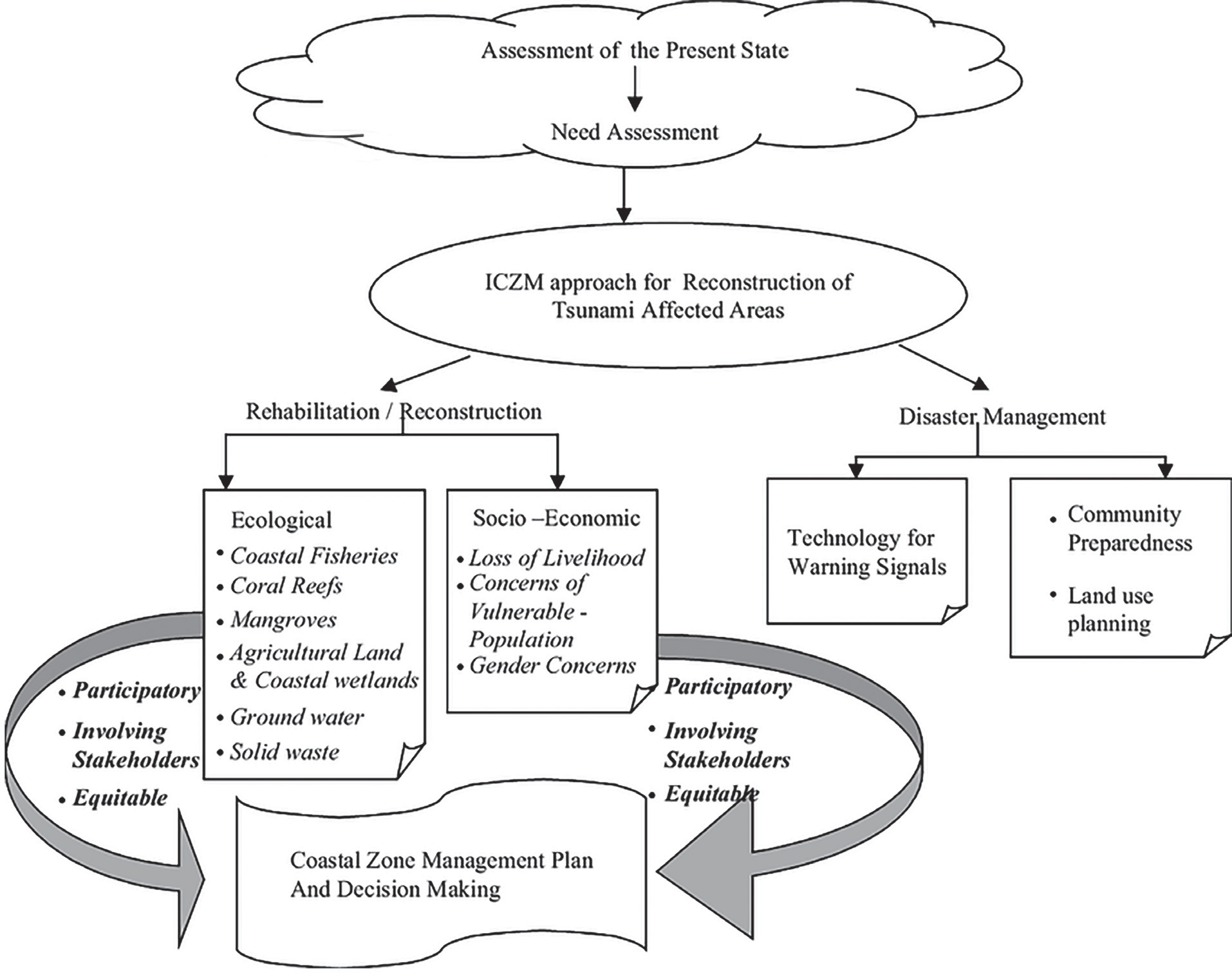
Figure: Integrated Coastal Zone Management Programme for Tsunami affected Regions
Inter-Agency Coordination
Inter-agency coordination is a key component of strengthening disaster risk governance. It is required among both central and state agencies in the field of Overall disaster governance, Response, Warnings, Information and data sharing and Non- structural measures.
Investing in DRR–Structural Measures
• Enhance the resilience of essential infrastructure and high-priority buildings.
• Develop shelters to protect against storm surges and tsunamis.
• Construct large-scale submerged sand barriers to mitigate tsunami impact.
• Conduct regular dredging of inlets and connected water bodies to help absorb the influx of water during a tsunami.
• Build submerged dykes, either in single or multiple rows along the coastline, to reduce the force of incoming tsunamis, along with inland dykes to safeguard critical installations.
• Ensure hazard-resistant construction, reinforcement, and retrofitting of all essential infrastructure and lifeline structures.
Investing in DRR–Non-Structural Measures
• Integrate disaster management (DM) considerations into both plan schemes and non-plan proposals across various ministries in accordance with established norms.
• Enforce and regulate relevant laws, including:
• Environmentally sustainable land-use zoning.
• Regulation of aquaculture and groundwater extraction.
• Ensure the implementation of prescribed standards across all departments and institutions.
• Formulate appropriate bylaws for rural areas, covering both engineered and non-engineered structures, while considering local conditions.
• Develop coastal sand dunes reinforced with seaweed, shrubs, or casuarina trees to enhance stabilization.
• Elevate ground levels above the design water level using natural beach sand to mitigate flooding risks.
• Establish coastal forests (green belts) by planting casuarina or coconut trees along the shoreline, ensuring a minimum coverage of 500 meters of beach width.
• Create bio-shields, such as mangrove plantations, to serve as natural barriers for communities living near estuaries.
• Safety Audits and evaluation of all lifeline structures and important facilities
• Promote private participation in disaster management facilities
Capacity Development
• Training and Capacity Building: Enhance the skills and knowledge of professionals in disaster management (DM).
• Educational Integration: Incorporate DM topics into academic curricula and develop technical expertise in various disaster-related subjects, including tsunamis.
• Awareness and Risk Reduction:
• Conduct mass media campaigns to promote disaster risk prevention, mitigation, and improved risk management.
• Encourage behavioral and attitudinal shifts through awareness programs and Information, Education, and Communication (IEC) initiatives.
• Advocate for the use of insurance and risk transfer mechanisms.
• Support the establishment and utilization of community radio for disaster awareness.
• Strengthen civil society networks for spreading awareness about Disaster Risk Reduction (DRR) and DM.
• Educate communities on the care and protection of animals affected by disasters.
• Emergency Preparedness:
• Organize mock drills and exercises to improve disaster response readiness.
• Distribute hazard zonation maps to coastal communities to raise awareness about tsunami risks and vulnerabilities.
• Community-Based Disaster Management:
• Enhance community resilience to disasters through a multi-hazard approach.
• Provide training for panchayat members, Self- Help Groups (SHGs), National Cadet Corps (NCC), National Service Scheme (NSS) participants, youth organizations, local community groups, and volunteers to improve disaster preparedness and response.
Steps Taken to Mitigate Tsunami
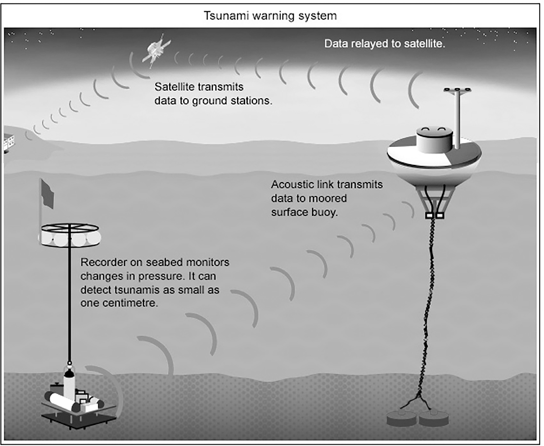
• The Indian Tsunami Early Warning System [ITEWS] comprises of a real time network of seismic stations, tsunami buoys and tide gauges. It is located at the Union Ministry of Earth Science’s Indian National Centre for Ocean Information Services [INCOIS] in Hyderabad.
• The real time seismic monitoring network comprises of 17 broadband seismic field stations transmitting real time data through V-SAT communication to the central receiving stations located at INCOIS and the National Centre for Seismology at New Delhi simultaneously for processing and interpretation.
•
The ITEWS has a network of seven Tsunami Buoy Systems equipped with the bottom pressure recorders that transmit real time data through satellite communication to INCOIS 24X7. The buoys are strategically placed at locations where a tsunami wave can reach in less than 30 minutes in case an earthquake occurs anywhere in Andaman-Sumatra and Makran Subduction zones.
• In addition, INCOIS has established a real time network of 31 tide gauge stations.
• The Tsunami Warning Centre disseminates the advisories to the various stakeholders through multiple modes simultaneously such as email, fax, phone, GTS and SMS. The earthquake information, tsunami bulletins as well as the real-time sea-level observations are also made available on INCOIS website for officials, public and media.
• ITEWC is currently establishing a network of 35 strong motion accelerometers and GNSS receivers at Andaman & Nicobar Islands. The major objective of the exercise is to improve the capability to characterise the rupture direction and area as to enable quicker estimation of the tsunamigenic potential of an earthquake.
• The new geospatial technologies such as 3D GIS has transformed the way in which coasts can be mapped and managed, which in turn can be used for improving the accuracies of coastal inundation modelling.
• INCOIS has, among other things, initiated preliminary work on cutting edge research areas such as:
• (i) Multi-hazard Vulnerability Mapping,
• (ii) Real-time tsunami inundation modelling
• (iii) 3-D GIS.
• The broad scientific methodologies have been established and pilot work has been successfully completed for a few areas.
Floods
Flood Risk Mitigation
Understanding Disaster Risk
Modernization ofObservation Network ; Assessment, Monitoring and Scientific studies.
Preparation of large-scale hazard maps of flood prone areas of high vulnerability.
Studies and monitoring of rivers flowing from neighbouring countries
Research and Development:
River Basin Analysis: Conduct comprehensive studies on river basins to understand their hydrological and ecological dynamics.
Research on Flood-Related Issues: Investigate challenges such as soil erosion due to river flooding, sediment transportation, river course alterations,
and the effective utilization of embankments.
Encouraging Research Initiatives: Support both internal and external research by offering grants to institutions and researchers for in-depth studies on flood management.
Hydrological and Morphological Assessments: Conduct thorough evaluations before implementing any major flood prevention or control measures.
Hazard Risk Vulnerability Assessment
Flood Hazard Zonation is also an essential step for future flood disaster management. The probability that a flood of a certain intensity will occur over an extended period is determined. Flood hazard is mainly used to define flood-prone zones.
National Remote Sensing Centre (NRSC)/ISRO has taken up development of Flood Hazard Zonation Maps using satellite data towards Disaster Risk Reduction, in addition to flood response.
The flood hazard maps prepared from satellite data were peer reviewed by a Committee constituted by National Disaster Management Authority (NDMA), which includes CWC (Central Water Commission), IMD (India Meteorological Department) and SDMA (State Disaster Management Authority).
Monitoring, Forecasting and Warning Systems
Dissemination of warnings, data, and information
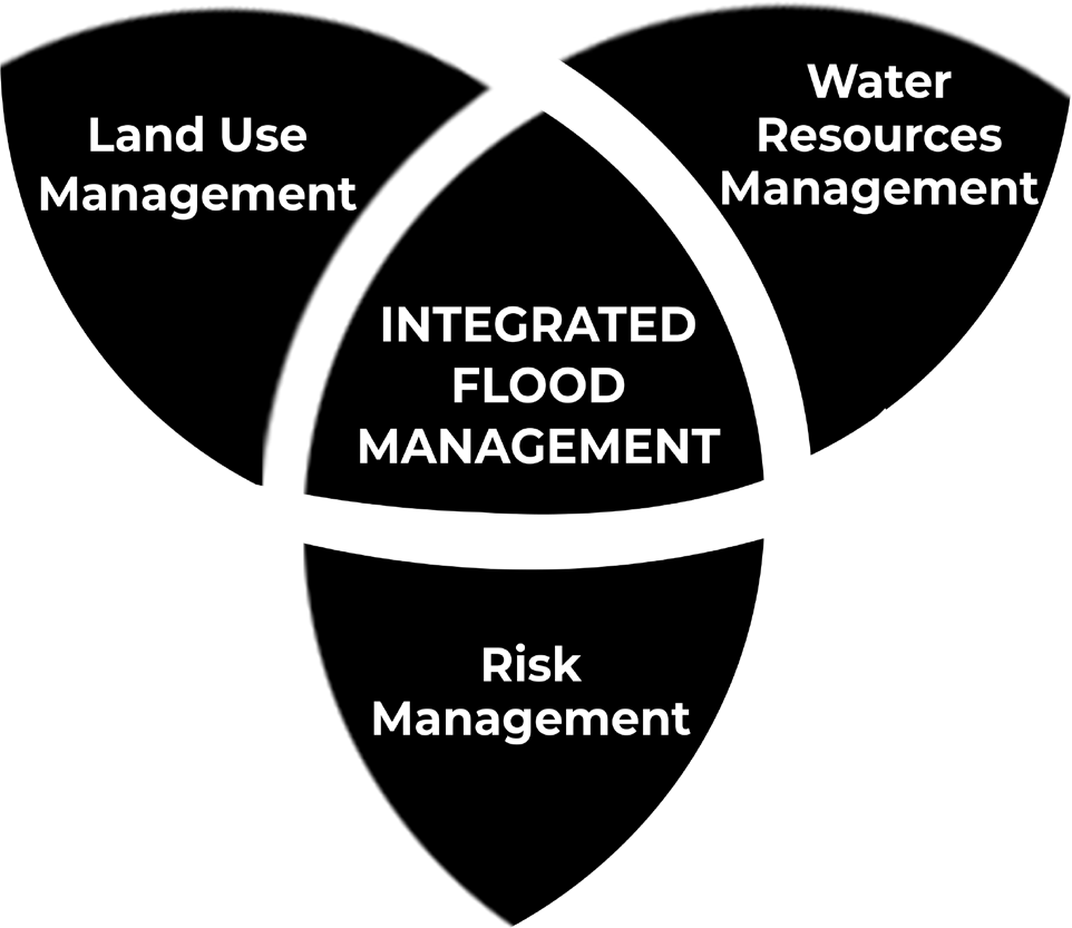
Figure: Integrated Flood Management
Integrated flood management (IFM):
It calls for a paradigm shift from the traditional, fragmented and localized approach, and encourages the use of the resources of a river basin as a whole, employing strategies to maintain or augment the productivity of floodplains, while at the same time providing protective measures against losses due to flooding.
Since IFM is essentially a dynamic notion, including emerging issues, such as risk management, urban floods, climate variability and change, and adaptive management.
IFM is holistic approach derived from Integrated Water Resources Management (IWRM) principles that stresses the interrelationship between socio-economic development, environmental sustainability and flood-risk management.
Inter-Agency Coordination: Inter-agency coordination is a key component of strengthening disaster risk governance. It is required among both central and state agencies in the field of Overall disaster governance, Response, Warnings, Information and data sharing and Non-structural measures.
Investing in DRR–Structural Measures
Identification of Safe Shelters: Locate secure buildings and sites to serve as temporary refuges for both people and livestock evacuated from flood-prone areas.
Construction of Multi-Purpose Cyclone Shelters: Build shelters in coastal villages and habitations that are frequently affected by cyclones to provide safety during disasters.
Maintenance of Drainage Systems and Embankments: Ensure proper upkeep of drainage networks and flood embankments to mitigate waterlogging and flood risks.
Incorporation of Flood-Resistant Features: Integrate flood-resistant designs in the planning and execution of social housing projects in flood-prone regions.
Implementation of Flood Safety Measures: Enhance safety and minimize flood risks through strategies like catchment flood modeling.
Pre- and Post-Monsoon Inspections: Conduct regular assessments of dams and reservoirs to identify vulnerabilities and implement necessary reinforcements.
Monitoring Safety Enhancements: Ensure that all safety improvement measures are effectively executed as per prescribed standards.
Desilting and Dredging of Rivers: Improve water flow by removing excess silt, enhancing drainage, and diverting floodwaters through existing or newly constructed river channels.
Hazard-Resistant Construction and Infrastructure Strengthening: Strengthen and retrofit lifeline structures and critical infrastructure to enhance resilience against floods and related disasters.
Investing in DRR–Non-Structural Measures
Implement regulations for land use in low-lying areas in accordance with flood control guidelines.
• Regulate habitation in low-lying zones along rivers, streams, and drainage systems to reduce flood risks.
• Ensure the effective implementation of a comprehensive plan to manage and mitigate floods.
• Periodically assess and revise operational guidelines for all major dams and reservoirs to enhance flood preparedness.
• Prevent and remove encroachments that obstruct natural water channels and drainage systems.
• Update and enforce relevant policies and regulations in flood-prone areas to minimize risks.
• Restrict activities that involve reclaiming wetlands and natural low-lying areas to maintain their role in flood control.
• Develop and implement strategies to protect wetlands and natural drainage systems to aid in flood moderation.
• Implement watershed management practices, including catchment area treatment and afforestation, to reduce flood risks.
• Promote involvement of private entities in disaster management infrastructure and facilities.
Capacity Development
• Training Programs for Government Staff and Professionals: Conduct orientation sessions on veterinary care and support for animals affected by disasters.
• Integration of Disaster Response in Youth Training: Include search and rescue operations in training programs for village volunteers and youth, with a focus on protecting disaster-affected animals.
• Curriculum Revision for Engineering Courses: Update undergraduate engineering syllabi to cover flood hazard mitigation and disaster-resistant construction techniques.
• Encouragement of Emergency Drills: Facilitate planning and execution of emergency drills across all ministries and States/UTs.
• Skill Development for Disaster-Resistant Construction: Provide training in building multi-hazard-resistant infrastructure, particularly in flood-prone areas.
• Public Awareness Campaigns: Utilize mass media, community radio, and other platforms to enhance disaster preparedness awareness.
• Gender-Sensitive and Inclusive Capacity Building: Ensure disaster management strategies incorporate gender equity and social inclusion at all levels.
• Community Disaster Preparedness: Strengthen local communities’ ability to manage and respond to disasters through a multi-hazard approach.
• Training for Local Organizations and Volunteers: Conduct training for panchayat members, SHGs, NCC, NSS, youth, and other community organizations to enhance disaster response skills.
Steps Taken to Mitigate Floods
Establishment of Rashtriya Barh Ayog (RBA): The National Flood Commission was formed by the Ministry of Agriculture and Irrigation in 1976 to assess India’s flood control measures after the National Flood Control Program of 1954 yielded limited success.
Financial Assistance for Flood Management: The Central Government has been funding flood control efforts under the Flood Management Programme (FMP) since the XI Plan.
Following initiatives have yielded significant results :
• National Flood Management Framework: A structured approach to flood mitigation and preparedness.
• Hydro-Meteorological Data Policy: Ensuring efficient dissemination of flood-related data for better decision- making.
• Deployment of Mobile Pump Units: Used during Delhi floods to manage waterlogging and mitigate flood impact.
• ‘Flood Watch’ Mobile Application: Provides real-time flood-related updates to enhance preparedness and response.
During X Plan, following four schemes were sanctioned to provide central assistance to the flood prone states to take up flood control and river management works in critical areas:
• Critical Anti-erosion works in Ganga Basin States (a Centrally Sponsored Scheme)
• Critical Flood Control and Anti Erosion Schemes in Brahmaputra and Barak Valley States (a State Sector Scheme),
• Improvement of Drainage in critical areas in the country (a State Sector Scheme)
• Critical Anti-erosion Works in Coastal and other than Ganga Basin States (a State Sector Scheme).
River Management Activities and Works Related to Border Areas (RMBA)
• During XI Plan, Government of India had approved implementation of the Central Sector Scheme “River Management Activities and Works related to Border Areas” for taking up non-structural measures such as Hydrological Observation and Flood Forecasting works on common border rivers, payment to neighbouring countries (China) for supplying HO data on common rivers, investigation of WR projects in neighbouring countries, activities of GFCC and Pancheswar Development Authority (PDA) was funded through this scheme.
• In addition to above activities, 100% Central Assistance was also provided for taking up structural measures such
as Anti Erosion/Flood Management schemes on rivers on international borders and Union Territories.
National Commission for Water Resources (1999):
• It suggested that storage dams and embankments provide effective protection to flood-prone areas and an urgent need to enact the flood plain zoning Act.
National Water Policy (2012):
• Formulated by the Ministry of Jal Shakti with the objective to take cognizance of the existing flood situation and to propose a plan of action from the national perspective. It suggested that through reservoir operation, the flood cushion can be set up to reduce the trapping of sediment during the flood season.
National Hydrology Project (2016):
• It is a central sector scheme under the Ministry of Water Resources, River Development & Ganga Rejuvenation; with 50% of the outlay amount received from the World Bank loan. The project gathers hydro-meteorological data which will be stored and analyzed on a real-time basis and can be accessed by any user at the State, District, and Village level.
Flood Plain Zoning
• Flood-plain zoning is a concept central to flood plain management. This concept recognises the basic fact that the flood plain of a river is essentially its domain and any intrusion into or developmental activity therein must recognise the river’s ‘right of way’.
• Flood-plain zoning measures aim at demarcating zones or areas likely to be affected by floods of different magnitudes or frequencies and probability levels, and specify the types of permissible developments in these zones, so that whenever floods actually occur, the damage can be minimised, if not avoided.
• The Central Water Commission (CWC) has been continuously impressing upon the states the need to take follow-up action to implement the flood plain zoning approach.
• A model draft bill for Flood Plain Zoning Legislation was also circulated by the union government in 1975 to all the states.
• There has been passive resistance on the part of the states to follow up the various aspects of flood plain management including possible legislation.
Flood Proofing
• Flood proofing measures adopted in India in the past, consisted in raising a few villages above pre-determined flood levels and connecting them to nearby roads or high lands.
• Under this programme, several thousand villages were raised in Uttar Pradesh in the fifties. In West Bengal
and Assam also land-fills were attempted in villages to keep houses above flood levels even though nearby agricultural lands were liable to inundation.
• During X Plan, the Government of Bihar had also constructed, with Central assistance, the raised platforms for safety of the people in flood prone areas of North Bihar.
CWC National Flood Forecasting Network
• Flood Forecasting and flood warning in India was commenced in a small way in the year 1958 with the establishment of a unit in the Central Water Commission (CWC), New Delhi, for flood forecasting for the river Yamuna at Delhi.
• Presently, there are 878 Hydrological and Hydro- meteorological sites being operated by CWC across the country covering 20 river basins for gauge, discharge, sediment & water quality observations.
• The formulation of a forecast requires effective means of real time data communication network from the forecasting stations and the base stations (380 nos approx at present).
• Flood Foreasting system comprises of Level Forecasting and Inflow Forecasting.
• The Level Forecasts help the user agencies to decide mitigating measures like evacuation of people and shifting people and their movable property to safer locations.
• The Inflow Forecasting is used by various dam authorities in optimum operation of reservoirs for safe passage of flood downstream as well as to ensure adequate storage in the reservoirs for meeting demand during non-monsoon period.
Watershed Management
• The watershed management measures include developing and conserving the vegetative and soil covers and also to undertake structural works like check- dams, detention basins, diversion channels, etc.
• In the watershed management of upper catchment, land treatment through afforestation and grass land development practices should be supplemented by structural works for retarding the water velocity and arresting silt.
Community based Management
The Intergovernmental Oceanographic Commission (IOC) of UNESCO has started a community performance- based programme known as “Tsunami Ready” for the promotion of tsunami preparedness by actively involving the public, community leaders, and national and local emergency management agencies.
Flood Risk Mitigation
Flood Risk Mitigation
Understanding Disaster Risk
Modernization ofObservation Network ; Assessment, Monitoring and Scientific studies.
Preparation of large-scale hazard maps of flood prone areas of high vulnerability.
Studies and monitoring of rivers flowing from neighbouring countries
Research and Development:
River Basin Analysis: Conduct comprehensive studies on river basins to understand their hydrological and ecological dynamics.
Research on Flood-Related Issues: Investigate challenges such as soil erosion due to river flooding, sediment transportation, river course alterations,
and the effective utilization of embankments.
Encouraging Research Initiatives: Support both internal and external research by offering grants to institutions and researchers for in-depth studies on flood management.
Hydrological and Morphological Assessments: Conduct thorough evaluations before implementing any major flood prevention or control measures.
Hazard Risk Vulnerability Assessment
Flood Hazard Zonation is also an essential step for future flood disaster management. The probability that a flood of a certain intensity will occur over an extended period is determined. Flood hazard is mainly used to define flood-prone zones.
National Remote Sensing Centre (NRSC)/ISRO has taken up development of Flood Hazard Zonation Maps using satellite data towards Disaster Risk Reduction, in addition to flood response.
The flood hazard maps prepared from satellite data were peer reviewed by a Committee constituted by National Disaster Management Authority (NDMA), which includes CWC (Central Water Commission), IMD (India Meteorological Department) and SDMA (State Disaster Management Authority).
Monitoring, Forecasting and Warning Systems
Dissemination of warnings, data, and information

Figure: Integrated Flood Management
Integrated flood management (IFM):
It calls for a paradigm shift from the traditional, fragmented and localized approach, and encourages the use of the resources of a river basin as a whole, employing strategies to maintain or augment the productivity of floodplains, while at the same time providing protective measures against losses due to flooding.
Since IFM is essentially a dynamic notion, including emerging issues, such as risk management, urban floods, climate variability and change, and adaptive management.
IFM is holistic approach derived from Integrated Water Resources Management (IWRM) principles that stresses the interrelationship between socio-economic development, environmental sustainability and flood-risk management.
Inter-Agency Coordination: Inter-agency coordination is a key component of strengthening disaster risk governance. It is required among both central and state agencies in the field of Overall disaster governance, Response, Warnings, Information and data sharing and Non-structural measures.
Investing in DRR–Structural Measures
Identification of Safe Shelters: Locate secure buildings and sites to serve as temporary refuges for both people and livestock evacuated from flood-prone areas.
Construction of Multi-Purpose Cyclone Shelters: Build shelters in coastal villages and habitations that are frequently affected by cyclones to provide safety during disasters.
Maintenance of Drainage Systems and Embankments: Ensure proper upkeep of drainage networks and flood embankments to mitigate waterlogging and flood risks.
Incorporation of Flood-Resistant Features: Integrate flood-resistant designs in the planning and execution of social housing projects in flood-prone regions.
Implementation of Flood Safety Measures: Enhance safety and minimize flood risks through strategies like catchment flood modeling.
Pre- and Post-Monsoon Inspections: Conduct regular assessments of dams and reservoirs to identify vulnerabilities and implement necessary reinforcements.
Monitoring Safety Enhancements: Ensure that all safety improvement measures are effectively executed as per prescribed standards.
Desilting and Dredging of Rivers: Improve water flow by removing excess silt, enhancing drainage, and diverting floodwaters through existing or newly constructed river channels.
Hazard-Resistant Construction and Infrastructure Strengthening: Strengthen and retrofit lifeline structures and critical infrastructure to enhance resilience against floods and related disasters.
Investing in DRR–Non-Structural Measures
Implement regulations for land use in low-lying areas in accordance with flood control guidelines.
• Regulate habitation in low-lying zones along rivers, streams, and drainage systems to reduce flood risks.
• Ensure the effective implementation of a comprehensive plan to manage and mitigate floods.
• Periodically assess and revise operational guidelines for all major dams and reservoirs to enhance flood preparedness.
• Prevent and remove encroachments that obstruct natural water channels and drainage systems.
• Update and enforce relevant policies and regulations in flood-prone areas to minimize risks.
• Restrict activities that involve reclaiming wetlands and natural low-lying areas to maintain their role in flood control.
• Develop and implement strategies to protect wetlands and natural drainage systems to aid in flood moderation.
• Implement watershed management practices, including catchment area treatment and afforestation, to reduce flood risks.
• Promote involvement of private entities in disaster management infrastructure and facilities.
Capacity Development
• Training Programs for Government Staff and Professionals: Conduct orientation sessions on veterinary care and support for animals affected by disasters.
• Integration of Disaster Response in Youth Training: Include search and rescue operations in training programs for village volunteers and youth, with a focus on protecting disaster-affected animals.
• Curriculum Revision for Engineering Courses: Update undergraduate engineering syllabi to cover flood hazard mitigation and disaster-resistant construction techniques.
• Encouragement of Emergency Drills: Facilitate planning and execution of emergency drills across all ministries and States/UTs.
• Skill Development for Disaster-Resistant Construction: Provide training in building multi-hazard-resistant infrastructure, particularly in flood-prone areas.
• Public Awareness Campaigns: Utilize mass media, community radio, and other platforms to enhance disaster preparedness awareness.
• Gender-Sensitive and Inclusive Capacity Building: Ensure disaster management strategies incorporate gender equity and social inclusion at all levels.
• Community Disaster Preparedness: Strengthen local communities’ ability to manage and respond to disasters through a multi-hazard approach.
• Training for Local Organizations and Volunteers: Conduct training for panchayat members, SHGs, NCC, NSS, youth, and other community organizations to enhance disaster response skills.
Steps Taken to Mitigate Floods
Establishment of Rashtriya Barh Ayog (RBA): The National Flood Commission was formed by the Ministry of Agriculture and Irrigation in 1976 to assess India’s flood control measures after the National Flood Control Program of 1954 yielded limited success.
Financial Assistance for Flood Management: The Central Government has been funding flood control efforts under the Flood Management Programme (FMP) since the XI Plan.
Following initiatives have yielded significant results :
• National Flood Management Framework: A structured approach to flood mitigation and preparedness.
• Hydro-Meteorological Data Policy: Ensuring efficient dissemination of flood-related data for better decision- making.
• Deployment of Mobile Pump Units: Used during Delhi floods to manage waterlogging and mitigate flood impact.
• ‘Flood Watch’ Mobile Application: Provides real-time flood-related updates to enhance preparedness and response.
During X Plan, following four schemes were sanctioned to provide central assistance to the flood prone states to take up flood control and river management works in critical areas:
• Critical Anti-erosion works in Ganga Basin States (a Centrally Sponsored Scheme)
• Critical Flood Control and Anti Erosion Schemes in Brahmaputra and Barak Valley States (a State Sector Scheme),
• Improvement of Drainage in critical areas in the country (a State Sector Scheme)
• Critical Anti-erosion Works in Coastal and other than Ganga Basin States (a State Sector Scheme).
River Management Activities and Works Related to Border Areas (RMBA)
• During XI Plan, Government of India had approved implementation of the Central Sector Scheme “River Management Activities and Works related to Border Areas” for taking up non-structural measures such as Hydrological Observation and Flood Forecasting works on common border rivers, payment to neighbouring countries (China) for supplying HO data on common rivers, investigation of WR projects in neighbouring countries, activities of GFCC and Pancheswar Development Authority (PDA) was funded through this scheme.
• In addition to above activities, 100% Central Assistance was also provided for taking up structural measures such
as Anti Erosion/Flood Management schemes on rivers on international borders and Union Territories.
National Commission for Water Resources (1999):
• It suggested that storage dams and embankments provide effective protection to flood-prone areas and an urgent need to enact the flood plain zoning Act.
National Water Policy (2012):
• Formulated by the Ministry of Jal Shakti with the objective to take cognizance of the existing flood situation and to propose a plan of action from the national perspective. It suggested that through reservoir operation, the flood cushion can be set up to reduce the trapping of sediment during the flood season.
National Hydrology Project (2016):
• It is a central sector scheme under the Ministry of Water Resources, River Development & Ganga Rejuvenation; with 50% of the outlay amount received from the World Bank loan. The project gathers hydro-meteorological data which will be stored and analyzed on a real-time basis and can be accessed by any user at the State, District, and Village level.
Flood Plain Zoning
• Flood-plain zoning is a concept central to flood plain management. This concept recognises the basic fact that the flood plain of a river is essentially its domain and any intrusion into or developmental activity therein must recognise the river’s ‘right of way’.
• Flood-plain zoning measures aim at demarcating zones or areas likely to be affected by floods of different magnitudes or frequencies and probability levels, and specify the types of permissible developments in these zones, so that whenever floods actually occur, the damage can be minimised, if not avoided.
• The Central Water Commission (CWC) has been continuously impressing upon the states the need to take follow-up action to implement the flood plain zoning approach.
• A model draft bill for Flood Plain Zoning Legislation was also circulated by the union government in 1975 to all the states.
• There has been passive resistance on the part of the states to follow up the various aspects of flood plain management including possible legislation.
Flood Proofing
• Flood proofing measures adopted in India in the past, consisted in raising a few villages above pre-determined flood levels and connecting them to nearby roads or high lands.
• Under this programme, several thousand villages were raised in Uttar Pradesh in the fifties. In West Bengal
and Assam also land-fills were attempted in villages to keep houses above flood levels even though nearby agricultural lands were liable to inundation.
• During X Plan, the Government of Bihar had also constructed, with Central assistance, the raised platforms for safety of the people in flood prone areas of North Bihar.
CWC National Flood Forecasting Network
• Flood Forecasting and flood warning in India was commenced in a small way in the year 1958 with the establishment of a unit in the Central Water Commission (CWC), New Delhi, for flood forecasting for the river Yamuna at Delhi.
• Presently, there are 878 Hydrological and Hydro- meteorological sites being operated by CWC across the country covering 20 river basins for gauge, discharge, sediment & water quality observations.
• The formulation of a forecast requires effective means of real time data communication network from the forecasting stations and the base stations (380 nos approx at present).
• Flood Foreasting system comprises of Level Forecasting and Inflow Forecasting.
• The Level Forecasts help the user agencies to decide mitigating measures like evacuation of people and shifting people and their movable property to safer locations.
• The Inflow Forecasting is used by various dam authorities in optimum operation of reservoirs for safe passage of flood downstream as well as to ensure adequate storage in the reservoirs for meeting demand during non-monsoon period.
Watershed Management
• The watershed management measures include developing and conserving the vegetative and soil covers and also to undertake structural works like check- dams, detention basins, diversion channels, etc.
• In the watershed management of upper catchment, land treatment through afforestation and grass land development practices should be supplemented by structural works for retarding the water velocity and arresting silt.
Community based Management
The Intergovernmental Oceanographic Commission (IOC) of UNESCO has started a community performance- based programme known as “Tsunami Ready” for the promotion of tsunami preparedness by actively involving the public, community leaders, and national and local emergency management agencies.
El-nino and La Nina
El-Nino and La Nina
El Nino:
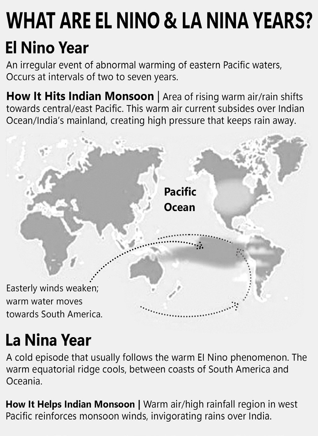
During a typical year with normal weather patterns, winds move westward, pushing warm surface water toward the western Pacific Ocean, which facilitates the upwelling of cold water from deeper ocean layers.
However, in certain years, when these winds weaken, warm water extends across most of the tropical Pacific Ocean. This prevents the rise of cool, nutrient- rich water along the eastern Pacific coast.
As a result, fish populations decline, and significant climate changes occur. The warm water shifts rainfall eastward, leading to droughts in Southern Asia and Australia while causing floods in North and South America.
La Nina:
La Nina is the reverse of El Nino. At the end of December, westbound winds get stronger than usual, pushing warm water further west than normal. As a result, there is enhanced upwelling of cold sea water.
This action allows hurricanes crossing the Atlantic to move farther west and to become more powerful than usual.
During a La Niña year, winter temperatures are warmer than normal in the South and cooler than normal in the North.
La Niña can also lead to a more severe hurricane season. La Niña causes the jet stream to move northward and to weaken over the eastern Pacific.
However, La Nina is generally good for the Indian summer monsoon.
The La Niña phase of the equatorial Pacific Ocean, active since 2021, had been expected to extend into 2023, marking only the third rare “triple-dip” event since 1950. Such long-lasting episodes usually aggravate climate extremes, intensifying floods in some areas and droughts in others. By 2024, however, La Niña weakened, and a short, weak resurgence occurred in late 2024 before fading by March 2025. The Pacific has now shifted to ENSO-neutral conditions, though forecasts suggest a possible return of a weak La Niña by late 2025, which could again influence global rainfall and temperature patterns.
El Niño and La Niña events happen every two to seven years. They usually last for 9-12 months but have been known to last for several years at a time.

• The World Metrological Organisation (WMO) predicts that global temperatures are likely to surge to record levels in the next five years due to a combination of climate change and El Niño. In 2016, it contributed to drought and food insecurity that affected tens of millions of people across southern and eastern Africa.
Impact of El Nino and La Nina
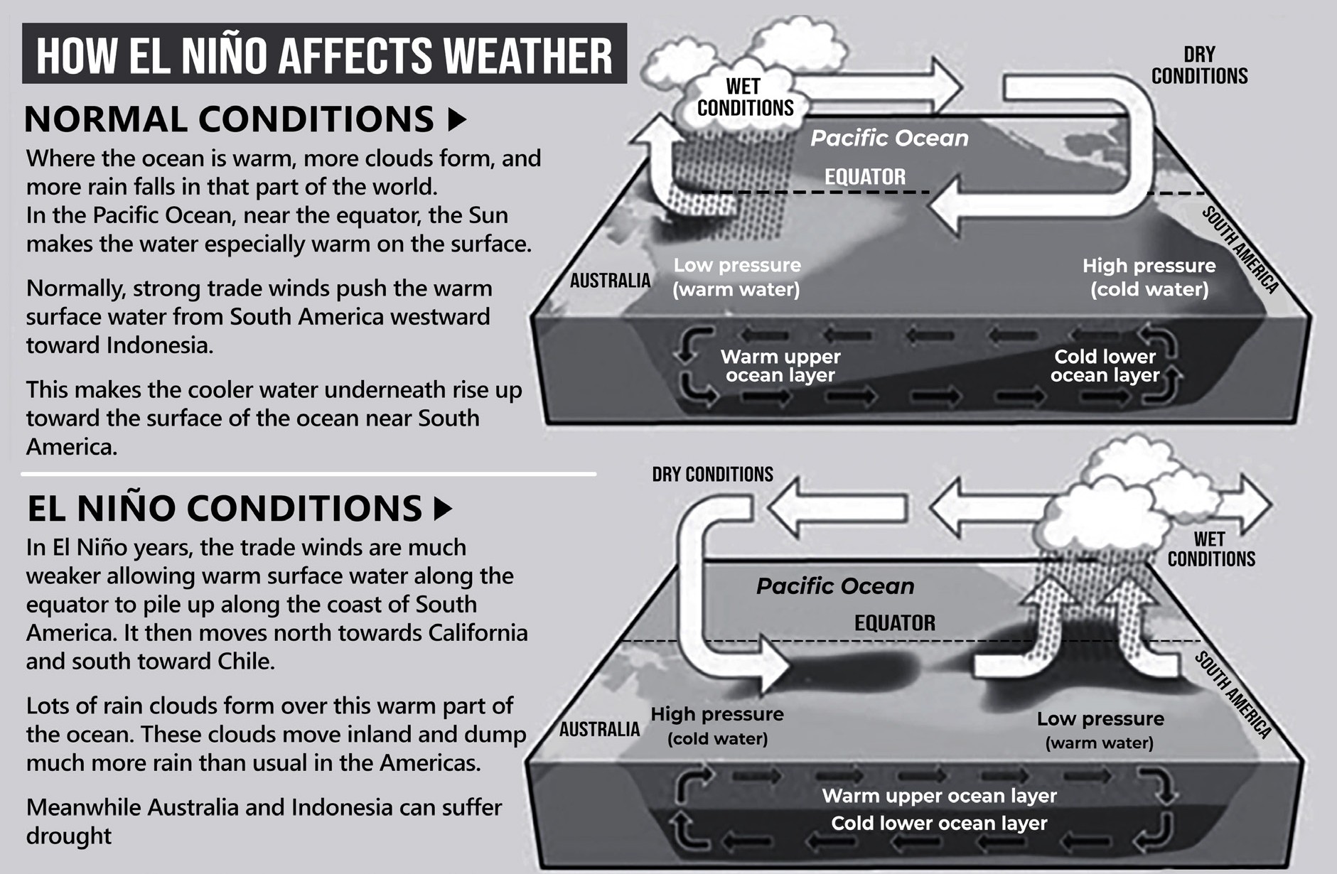
• However, El Niño and La Niña events are not mirror images of each other. They differ in length and strength.
• El Niño episodes occur more frequently and are usually associated with more impactful weather events. An El Niño is more likely to be a single-year event.
• La Niña, on the other hand, has a longer run. That is why multi-year La Niña events, those that continue for more than 12 months, are quite common.
Impact of El-Nino
• They can also cause increased rainfall in southern South America, the southern United States, the Horn of Africa and central Asia.
• During summer in the northern hemisphere, El Niño’s warm waters can result in more intense tropical cyclones in the western Pacific, but fewer Atlantic hurricanes.
• In Ecuador and Peru, where flooding earlier this year has already fueled a rising dengue outbreak, the risk is now compounded by expectations of El Niño–driven rains in early 2025. By contrast, in southern Africa, although vast drought-affected areas have struggled with cholera outbreaks (with over 178,000 confirmed cases in Eastern and Southern Africa between 2024 and early 2025) , it remains unclear whether drier conditions will ease transmission or worsen water scarcity and sanitation challenges, thus influencing the epidemic’s trajectory.
• With all the extra heat at the surface of the Pacific Ocean, energy is released into the atmosphere, causing an overall warming of the global climate temporarily. Years in which
El Niño occurs tend to feature higher temperatures across the globe.
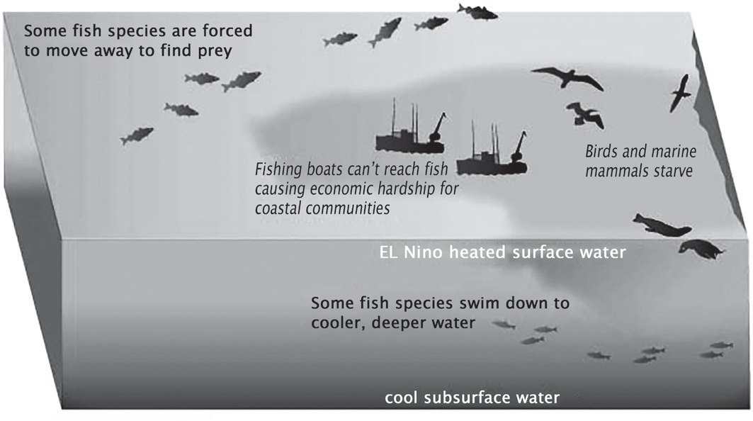
Figure: Impact of El Nino on Fishes
• In Asian countries, there is typically a decrease in rice production. With an increase in droughts on the western side of the equatorial Pacific, GDP in the countries in that area tend to drop during the El Niño cycle.
• In non-Asian countries such as Australia, the droughts can cause a decrease in the harvesting of other crops, like wheat.
• Meanwhile, the dramatic increase in rainfall on the eastern equatorial Pacific cause flooding, property damage, displacement and seek shelter elsewhere.
• Fishing in equatorial coastal countries like Ecuador and Peru becomes difficult, as fish in the waters near these countries tend to disappear in the months of December and January.
• Overall, the drastic change in weather that occurs due to El Niño has a negative economic impact on many countries near the equator. While normal years offer more stable weather, thus leading to more predictable effects on certain markets, El Niño years have a dramatic shift in the weather pattern that leads to extreme weather on either side of the equatorial Pacific. This extreme weather, whether it be drought or flood, has a negative impact on the living conditions and extraction of natural resources in Tropical countries.
Impact of La Nina
• In most parts of the United States, for example, La Niña is associated with very dry winters.
• In Australia and Indonesia, and generally in the tropical region, La Niña is expected to bring more rainfall.
• The widespread drought in the United States and flooding in eastern Australia this year could have been a result of the prolonged La Niña.
• The excessive rainfall in Pakistan, which is experiencing its worst flooding disaster, can also be blamed in part on La Niña.
• It said that the persistence of La Niña was most likely to result in a worsening of the drought in Africa.
Cloudbursts and Flash Floods
Cloudbursts and Flash Floods
Cloudburst is defined as an extreme amount of precipitation in a short span of time, which creates flash- flood conditions. It is often accompanied by thunder and lightning.
A cloudburst can occur anytime and at any place which is affected by convective weather systems.
According to Indian Meteorological Department (IMD), Cloudburst is an unexpected precipitation that exceeds 100mm (or 10 cm) per hour across a region of land that is between 20 and 30 square kilometres.
Most cloudbursts take place between 1,000 and 2,500 metres above sea level, and they are followed by significant flooding particularly Flash Floods and Landslides.
• Intense weather events, especially when more than 10 centimeters (3.94 inches) of rainfall occurs within a 10 square kilometers (3.86 square miles) region within an hour, are called Cloudbursts.
• Flash Floods occur in a much shorter span of time (say, when rainfall creates flooding in less than 6 hours) and are highly localised. Flash-floods are mostly the result of cloudbursts or blockage of river channel due to landslides.

Figure: Cloud Burst
• As India surrounded by oceans from three sides. Hence, it is a favourable location for convective weather systems.
| Convective Weather System Location | Result |
| Bay of Bengal | Rainfall over the Indian subcontinent |
| Western Pacific Ocean | Diverts rain-bearing winds away from the Indian subcontinent |
•
During Cloudburst, massive coagulated clouds with heavy water content hover, over a very small location. They simply collapse under their own weight causing flash floods.

Figure: Mechanism of Cloudburst
• Famous Example is 2013 Uttarakhand Cloudburst and Flash Floods where heavy snowfall occurred in
Himalayas and non-stop heavy rainfall. It helped the snow to melt fast from Chorabari Glacier as water has a higher heat capacity and molecules in liquid water are more tightly packed than air, leading to greater rate of heat transfer and snow melting from Chorabari glacier. This led to rise in water level in the river Mandakini and Chorabari Lake.
• These flash floods washed the mud, stones and slush (partially melted snow) from mountains into rivers. Thus, all those shops, hotels, apartments were destroyed and road network erased hence relief could not reach on time.
• Flash floods caused by cloudbursts have caused significant damage to villages and cities in the Himalayan regions of Kashmir and Ladakh in India. Examples of Mumbai cloudburst of July 2005, Kedarnath cloudburst of 2013 which caused more than 5,000 deaths and loss of property worth crores of rupees, Cloud Burst in Dehradun 2022, Amarnath cave, 2022, Sikkim 2023.
• In Uttarkashi (Uttarakhand), August 5, 2025: A cloudburst in the Dharali area near Harsil triggered flash floods and mudslides. Several houses, hotels, and roads were destroyed; at least 4-5 people died and dozens went missing.
• In Chositi, Kishtwar district (Jammu & Kashmir), August 14, 2025: A cloudburst led to flash floods that killed about 68 people, injured over 300, and left many missing. The affected included pilgrims on the Machail Mata Yatra route.
• In Uttarakhand (Rudraprayag and Chamoli districts), August 29, 2025: Cloudbursts caused flash floods, with at least 4 people reported dead and several missing. Families were trapped under debris in affected areas.
Do cloudbursts happen only in the mountains and hilly areas?
• There is a greater probability of them occurring in mountainous zones, though they occur in plains also.
• When vapour saturated clouds face upward movement of very warm current of air.
• New drops are formed and existing raindrops increase in size. After a point, the raindrops become too heavy for the cloud to hold on to, and they fall together in a quick flash.
• Thus, hilly areas help in heated air currents rising vertically upwards, thereby, increasing the probability of a cloudburst situation.
• Cloudbursts get acknowledged only when they result in largescale destruction of life and property, which happens mainly in mountainous regions.
Is 2013 Incident a man-made disaster?
• There are various causes of Uttarakhand incident which include
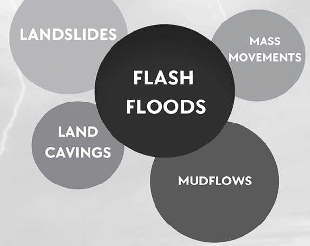
Figure: Consequences of Cloudbursts
• Roads causing landslides
• Huge expansion of roads and transport.
• Heavy machines plying the earth everyday.
• Even dynamites are used to cut the mountains and make roads.
• Unscientific construction: They say damage caused by cloudbursts is also increasing because of unplanned development in mountain regions.
• In 2012, government notification declared the region of Gaumukh and Uttarakashi, along the Bhagirathi River, as an Eco-Sensitive Zone which banned:
• Hydropower projects which changes river courses, poor structural safety
• Mining and use of dynamites
• Construction activities, especially hotels, resorts, guest houses and travel lodges on the river bed.
• Lack of Political Will
• Ad-hoc and unplanned development, without medium term or long-term plan or vision apart from corruption by builders, mining mafias and bureaucrats.
• Outdated Disaster Management Approach
• The emphasis has been on post-disaster response, rescue, evacuation and relief rather than following the ‘Disaster Management Continuum’ that lays more stress on pre-disaster early warning, mitigation and risk reduction of disaster events.
• Inefficient Bodies and Lack of Infrastructure
• Indian Metrological Department was unable to alert as it didn’t have Doppler radars in the Himalayan region to predict onset of cloudbursts.
• National Disaster Management Authority (NDMA)
didn’t even have sufficient life-jackets in Rudraprayag.
• Overall, there was no accountability and no coordination.
• Global Warming and Climate Change
• Experts attribute the increasing frequency of cloudbursts to global warming, which is resulting in more evaporation of water and because of this dense cumulonimbus clouds are forming, resulting in intense rainfall.
Can we Predict and Prevent Cloudbursts?
• The specific location and time of cloud burst can be predicted in NOWCAST mode only, i.e. a few hours in advance. To detect these sudden developments, you need a Doppler Weather Radar (DWR).
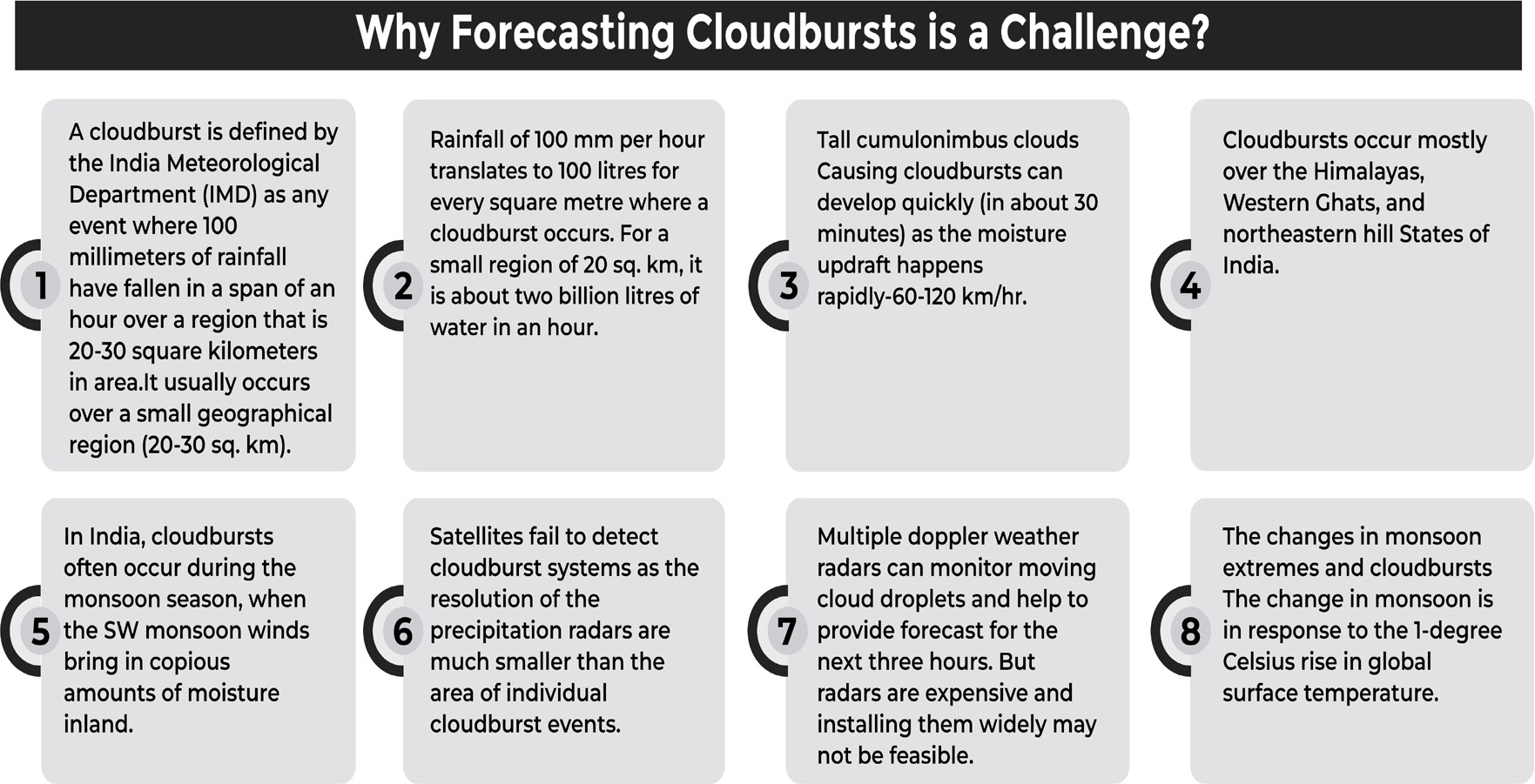
Figure: Cloud burst Forecasting
Doppler Weather Radar (DWR)
• By and large, Meteorologists use there are three different types of weather radars:
• Conventional: gives information only about the rainfall estimation
• Doppler: Measuring rainfall, winds and clouds, can cover an area ~400 km
• Polarisation radar (or multi-parameter radar): measure winds, rainfall (including shape and number of raindrops)
• Benefits of Doppler Weather Radar
• Radar uses the Doppler Effect in microwaves. When Microwaves are reflected from objects at different times, this Radar detects their relative position. Thus, Doppler Radar can detect even tiny water particles in clouds and in which direction they’re moving.
• Doppler radar has a detection range of ~400 kms. It can transmit information about a cloud, its distance from land, its composition, which direction it is moving and even minute details like the number and size of water droplets found in a cloud.
• We can predict the amount of rainfall to an area, 2-3 hours in advance. Thus, if a flood-like situation is likely to happen in Mumbai, BMC could be alerted to avert a 2005-like disaster.
• It can predict thunderstorms as well.
• However, Real-time Early Warning of Cloudbursts has still not been developed. Doppler radars that can predict sudden changes in the weather about three to six hours in advance can assist in early warning for cloudbursts.
•
These have been fixed in the western and eastern Himalayas and in the plains as well — numbering 33 at present — with their presence continuously increased to be used in a Multi-Hazard Early Warning System related to heavy rainfall and snow.
• These are being upgraded by the Union Ministry of Earth Sciences, with the number targeted to be raised to 90, to forecast cloudbursts and heavy rainfall events at least two days in advance, which would assist in evacuating people beforehand.
Glacial Lake Atlas
• National Remote Sensing Centre, as one of the Central Implementing Agency of National Hydrology Project (NHP) sponsored by Ministry of Jal Shakti, Department of Water Resources, River Development and Ganga Rejuvenation (DoWR, RD&GR), Govt. of India. As part of this, NRSC carried out inventory & mapping of Glacial Lakes of size ≥0.25ha Himalayan Region of Indian River Basins. Using the above, NRSC brought out Glacial Lakes Atlas of Indus and Ganga river basins.
• These atlases are useful for identifying the potential critical glacial lakes and consequent GLOF risk assessment. It also assists disaster mitigation planning and related programs for Central and State Disaster Management Authorities.
Crisis Mapping
• Crisis mapping is the real-time data gathering and analysis during natural disaster or riots, elections etc.
• During Uttarakhand tragedy,International Network of Crisis Mappers came to help. These crisis mappers
monitor different channels of information on Uttarakhand. Example
• Official sources,
• Blogs, social media, facebook twitter
• NGOs
• News Media
• Using such data, the Crisis Mappers generate ‘situation reports’. They also update with vital information an online crisis map set up by the Google having information on rescued people, cleared areas, people stranded, relief camps, medical centres, road networks and so on.
• Thus, crisis mapping helps bridge the gap between
• Information-seekers vs providers
• Government vs public
• Situation on the ground vs action that needs to be taken
• Ushahidi is an open-source platform for crisis mapping during 2010 Haiti Earthquake. They even had an international SMS number which was created for people to input information relating to the quake.
• South Asian Flash Flood Guidance System by IMD.
• Google Person Finder is a web application that -
• Allows individuals to post and search for the status of relatives or friends affected by a disaster.
• It also lets press agencies, non-governmental agencies etc. contribute to the database and receive updates. This was utilized during rescue & relief operations in Uttrakhand flash floods.
Mitigation of Cloudbursts and Flash Floods
Mitigation of Cloudbursts and Flash Floods
Measures of NDMA (National Disaster Management Authority) for cloudbursts:
• Follow Disaster Management Continuum Approach, which is safe, economically feasible and advantageous.
• Technology: Real-time Early Warning of Cloudbursts must be developed. Doppler Radar system and Early Warning Dissemination systems be expanded.
• Advanced Planning with Community-Based Disaster Management must be promoted.
• Localized planning that incorporates the surrounding community and considers the ecological fragility of the region.
• Promote planned developments in climate- vulnerable regions such as the Himalayas.
• When there are known flood paths, it is best to avoid any construction in those regions.
• It is important for people living on foothills or slopes to be moved to higher ground when heavy rains are likely to occur to minimize loss of life.
• Cloudburst Hotspots have to be identified, risk mapping done and management initiated from these places.
•
Infrastructural development like strengthening of dams, barrages, and embankments to regulate and control water flow.
• Adoption of eco-friendly legislation and eco-aware tourism for the development of the region.
• Ecological Stabilization:
• To reduce the chances of landslides, there afforestation should be promoted.
• Similarly, ensuring smooth flow and drainage of rainwater in the plains would prevent human, animal and infrastructural losses after cloudbursts and heavy rain.
Mitigation can be made more successful by utilising and leveraging local resources and expertise.
By joining and collaborating with local organisations like Gram Sabhas, and Panchayats, NGOs and communities will improve the disaster management system as a whole.
The capacity and capability building of such human resources be ensured.
• Watershed Management that stabilises the hill landscape and ensures better tackling of resultant landslides, flash floods, mudflows and land-caving needs to be adopted. These measures should be strategically implemented first in the hotspots.
• The computerisation of the distribution of monetary disaster relief has to be completed where not yet accomplished for ensuring instantaneous flow to the needy.
• Immediate relief in the form of food, water and medicines needs to be provided for preventing post- disaster complications. The rehabilitation operation should be executed with the purpose of bringing back sustainable livelihoods and assisting people in returning to normal life.
• Where the damage is colossal, reconstruction and rehabilitation must be undertaken on a war footing. All these activities have to be taken to the last mile and assessed through participatory monitoring to gauge the effectiveness of the interventions.
• The implementation of all these steps of the disaster management continuum, as contained in the National Policy of Disaster Management, 2009, would assist in achieving cloudburst resilience and reflect India’s commitment to comply with the UN’s Sendai Framework of Disaster Risk Reduction that various countries are trying to achieve before 2030.
Urban Floods
• Urban Floods
• The problem of urban flooding is a result of both natural factors and land-use changes brought about by urban development.
• Urban flooding differs significantly from rural flooding due to urbanization, which results in developed catchments that amplify flood peaks by 1.8 to 8 times and increase flood volumes by up to six time.
• It occurs due to a combination of meteorological, hydrological, and human-induced factors. Changes in land use contribute to rapid flooding in urban areas, leading to high water flow.
• Several major Indian cities have experienced loss of life and property, disruptions in transportation and power supply, and outbreaks of epidemics. Therefore, managing urban flooding should be treated as a top priority.
• The consequences of urban flooding can be extensive, including temporary displacement of people, damage to infrastructure, decline in water quality, and increased risk of disease outbreaks
• Urban Flood vs Rural Flood
• Widespread rural flooding is primarily caused by several key factors:
• During the monsoon season, rivers carry a heavy sediment load from their catchments. When combined with the inadequate capacity of rivers to hold water, this leads to flooding, drainage congestion, and erosion of riverbanks.
• Cyclones, cyclonic circulations, and cloudbursts can trigger flash floods, resulting in significant losses. Additionally, some rivers responsible for severe flooding in India originate from neighboring countries, adding another layer of complexity to the issue.
•
Urban flooding differs greatly from rural flooding due to urbanization, which results in developed catchments that increase flood peaks by 1.8 to 8 times and flood volumes by up to six times.
• Flooding occurs rapidly due to shorter flow times, sometimes within minutes.
• Developed catchments in cities lead to higher runoff levels.
• The predominance of solid surfaces prevents water infiltration and percolation, worsening the situation.
• High population density in urban areas increases the number of people at risk, leading to greater loss of life.
• Flooding also raises exposure to infections, further heightening human vulnerabilities.
• Poor urban planning and inefficient drainage systems exacerbate flooding issues.
• Since urban areas are economic hubs with critical infrastructure, flood-related damage can have far- reaching consequences beyond local areas, impacting the entire nation.
Urban Flood Risk in India
India has witnessed a rising trend of urban flooding disasters over the years, severely impacting major cities. Some of the most significant instances include Hyderabad in 2000, Ahmedabad in 2001, Chennai in 2004, Mumbai in 2005, and Delhi in 2023, among others.
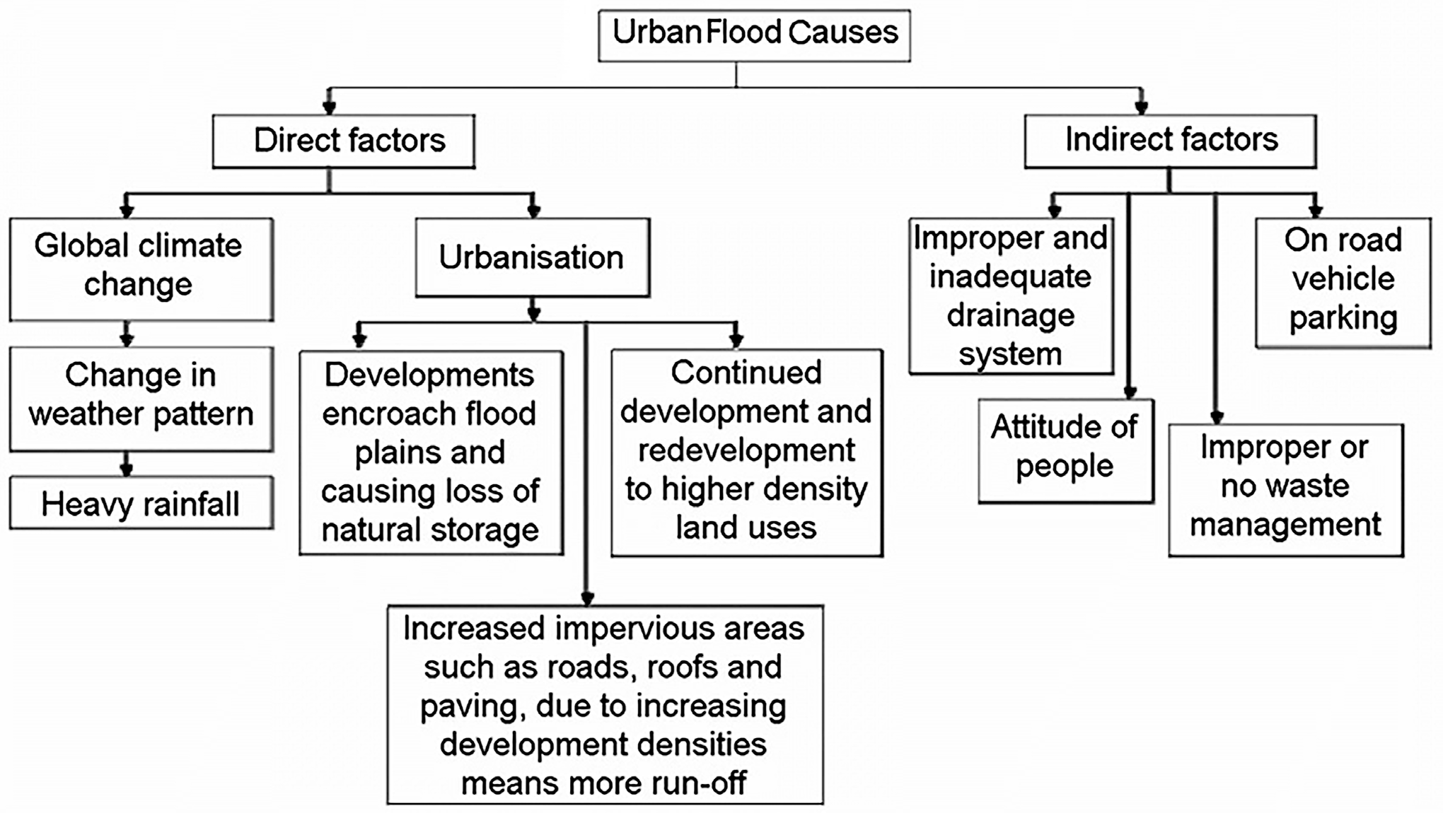
Figure: Causes of Urban Floods
• A distinct characteristic of India’s climate is the occurrence of heavy rainfall during the monsoon season. Additionally, other weather systems contribute to significant rainfall. Coastal cities and towns are also vulnerable to storm surges.
Furthermore, the sudden release or delayed discharge of water from dams can have severe consequences.
• Moreover, the Urban Heat Island Effect has led to increased rainfall in urban areas. Global climate change is altering weather patterns, resulting in more frequent high-intensity rainfall events within shorter durations. Additionally, the looming threat of rising sea levels poses a significant risk to coastal cities. Urban areas situated along coastlines, riverbanks, upstream or downstream of dams, in hilly regions, and even inland cities are all vulnerable to these impacts.
• Issues in Urban flooding
Stormwater drainage systems in the past were designed for rainfall intensity of 12 – 20 mm. These capacities have been getting very easily overwhelmed whenever rainfall of higher intensity has been experienced.
Further, the systems very often do not work to the designed capacities because of very poor maintenance.
Encroachments pose a significant challenge in many cities and towns. Natural streams and watercourses have evolved over thousands of years due to the continuous flow of water within their respective watersheds. Over time, human settlements expanded into towns and cities along these rivers and streams, leading to an increase in water flow proportional to urbanization.
Ideally, just as roads are widened to accommodate increased traffic, natural drains should have been expanded to manage the rising volume of stormwater. However, large-scale encroachments on natural drainage channels and river floodplains have occurred instead. As a result, the capacity of these natural drains has significantly decreased, causing frequent flooding.
Additionally, improper disposal of solid waste— including household, commercial, and industrial waste— as well as the dumping of construction debris into drainage systems, has further reduced their efficiency. It is crucial to implement better maintenance and operational measures to address these issues effectively.
Flood Risk Reduction in China
• In China, the reclamation and utilization of lakes, floodplains, and upstream slopes have significantly reduced the capacity to store and discharge floodwaters. Implementing flood control measures has been challenging due to conflicts between local interests and the broader river basin management, leading to inefficient flood operations during flood periods.
• Following the severe flooding event of 1998, China has adopted an integrated approach to water resource and flood management, including:
Formulating water development plans that consider all relevant factors, with a focus on multipurpose use and balancing water utilization for livelihoods, development, and environmental sustainability.
Incorporating water resource development programs into national and social development planning.
Establishing a water management system that integrates river basin management with administrative divisions, primarily provinces.
Prohibiting any construction, infrastructure development, or activities within designated river channel management zones that could hinder flood discharge capacity.
The central government has laid down specific policies for implementation of the above- mentioned laws, comprising:
Restoration of reclaimed areas like slope area, lake area and the flood prone areas to natural forest and lakes with government subsidy;
Relocation of people of these reclaimed areas and economic compensation and tax exemption for the settlers; and
Restraining the economic development and control of the population growth in flood prone areas, especially in frequently flooded areas.
Specific policies to cope with soil and water loss in mountainous and hilly areas include:
Integrated regulation and management of small catchments;
Establishment of a contract system for regulation and management of small catchment in soil eroded areas;
Reinforcement of prevention of soil erosion; and
Establishment of a market-oriented mechanism in soil and water conservation
Urban Flooding Risk Mitigation
Urban Flooding Risk Mitigation Understanding Disaster Risk
• Mapping/ Zoning.
• Estimation of Possible Inundation levels.
• Estimation of Flood Damages.
• Ward level Risk Reduction and Vulnerability Assessment.
• Maximize real-time hydro-meteorological network to cover all urban centers.
• Establish satellite-linked Automatic Rain Gauge Stations, Automatic Weather Stations for 24x7 Weather monitoring
• Coordinate with IMD in setting up of local networks at identified places
• Coordinate with the central agencies
• Hazard Risk Vulnerability Assessment
• Develop Blue Green Infrastructure (i.e. water bodies and parks ), flood walls, Bioswales (along roadsides for water percolation) etc.
Inter-Agency Coordination
• It is required among both central and state agencies in the field of overall disaster governance, Response, Warnings, Information and data sharing and non-structural measures.
Investing in DRR–Structural Measures
• Urban Design
• Airports to be made flood-proof by providing efficient drainage for a much higher rainfall intensity.
• All future road and rail bridges in cities crossing drains to be designed such that they do not block the flows resulting in backwater effect.
• All road re-levelling works or strengthening/ overlay works to be carried out by milling the existing layers of the road so that the road levels will not be allowed to increase.
• Ensure protection of Water Bodies and its restoration/ revival.
• Remove encroachments and take strict action against the encroachers as per the bylaws/ regulations.
• Establishment of Emergency Operation Centres
• Hazard resistant construction, strengthening and retrofitting of all lifeline structures and critical infrastructure.
Investing in DRR–Non-Structural Measures
• Preparation of comprehensive Urban Storm Drainage Design Manual (USDDM)
• Preparation of Storm Water Drainage System Inventory
Operation and Maintenance of Drainage Systems
Environmental Impact Assessment
• To ensure strict compliance of Techno-Legal Regime through ULB
• Constitution of Urban Flooding Cell for Integrated UFDM
• Promote private participation in disaster management facilities.
Capacity Development
• Urban Flood Education and Training
• Ensure accurate documentation of all aspects of disaster events for creating good historical records for future research and mitigation planning.
• Empowering women, marginalized and persons with disabilities by incorporating gender sensitive and equitable approaches in capacity development covering all aspects of disaster management at the state, district and local levels.
• Awareness Generation
• Carry out mass media campaigns
• Promote culture of disaster risk prevention, mitigation and better risk management
• Promote attitude and behaviour change in the awareness campaigns/ IEC
• Promote use of insurance/ risk transfer
• Promote Community Radio
• Strengthening network of civil society organizations
for awareness generation about DRR and DM.
• Information on care and protection of disaster- affected animals.
• Community-Based Disaster Management
• Strengthen ability of communities to manage and cope with disasters based on a multi-hazard approach
• Training for panchayat, SHG, NCC, NSS, Youth, local community organizations.
• Mock Drills/Exercises
Steps Taken to Mitigate Urban Floods
• Jal Shakti Abhiyan (JSA) in the country in which special emphasis is being given for rainwater harvesting/ groundwater recharge. First JSA was launched in 2019 in water stressed blocks of 256 districts.
• Amrit Sarovar Mission has been launched with an aim of developing and rejuvenating 75 water bodies in each district of the country as a part of celebration of Azadi ka Amrit Mahotsav for rainwater harvesting/recharge.
• Atal Bhujal Yojana involving the local communities at village levels with an outlay of Rs. 6,000 crore, in collaboration with States, in certain water stressed areas of Gujarat, Haryana, Karnataka, Madhya Pradesh, Maharashtra, Rajasthan and Uttar Pradesh. Under Atal Bhujal Yojana, the focus is on demand side management of ground water and accordingly water saving interventions such as use of micro irrigation (drip/sprinkler system), shifting of cropping pattern from high water intensive crops to low water intensive crops, mulching etc. are being encouraged and incentivised.
• Under the Atal Mission for Rejuvenation and Urban Transformation (AMRUT) 2.0 Scheme, provisions have been made for harvesting the rainwater through storm water drains into water body (which is not receiving sewage/effluent) & creation/ strengthening of storm water drains around water body.
• Model Building Bye Laws (MBBL), 2016 for the States/ UTs were formulated by Ministry of Housing & Urban Affairs (MoHUA). As per MBBL, all buildings having a plot size of 100 sq.m. or, more shall mandatorily include the complete proposal of rainwater harvesting. 35 States/ UTs have adopted the features of the Bye Laws.
• Master Plan for Artificial Recharge to Groundwater – 2020: It has been prepared by the Central Ground Water Board (CGWB) in collaboration with States/UTs. The plan aims to construct about 1.42 crore rain water harvesting and artificial recharge structures. Sponge Cities Mission for civic planning
Landslide Risk Mitigation Strategy
Landslide Risk Mitigation Strategy
To carry out the risk mitigation work, a team of cross-sectoral and interdisciplinary professionals which include geologists, engineers, architects, physical planners, public/community, disaster managers, policy and decision makers have to play a proactive role. The mitigation and management strategy must have a combination of features like:
Understanding Disaster Risk
Hazard Zoning
Mapping and Investigations: Conduct geological and geotechnical studies in landslide-prone areas.
Scientific Assessment: Analyze factors contributing to landslides to predict their likelihood and better understand the forces driving them.
Climate Change Impact: Assess how changing climate patterns influence landslide occurrences.
Research and Development: Develop methods to minimize the factors that contribute to landslides.
Hazard Risk and Vulnerability Assessment
Evaluate vulnerability based on social, economic, ecological, gender, and equity aspects.
Assess changes in risk and vulnerability under different climate change scenarios.
Warning Dissemination
Ensure adequate infrastructure and facilities to provide timely access to at-risk communities.
Deliver warnings effectively to all, including remote, rural, and urban populations, with regular updates for those in danger zones.
Monitoring and Early Warning Systems
• Implement effective monitoring, warning mechanisms, and dissemination strategies to mitigate landslide risks.
Investing in DRR–Structural measures
Structural measures are those measures which include physical construction to reduce or avoid possible impact of hazards. These measures include engineering solutions, such as
• Drainage control measures through provisions of surface and subsurface drains.
• Retaining and reinforcement structures.
• Deflection spurs at the toe to avoid erosion from the rivers.
• Landslide treatment methods like shotcreting, grouting, netting, wire-meshes and sealing of cracks / fissures on the hills.
• Adopt remedial techniques like buttresses, shear keys, sub-drains, soil reinforcement etc.
• Construction of retaining walls, afforestation, terrace farming.
Investing in DRR–Non-Structural Measures
Non-Structural Measures are all such measures where efforts are made to mitigate the impact of landslides without construction of disaster resistant features. Methods may include:
• Hazard Mapping and Effective Land Use Planning: Landslide hazard maps help identify high-risk areas, preventing the development of settlements in these zones. Such regions should ideally be reserved for permanent vegetation to maintain stability.
• Surface Drainage Management: Implementing surface drainage control measures reduces water infiltration during heavy rainfall, limiting landslide movement. Reforestation efforts aid in stabilizing the topsoil, preventing erosion and runoff, thereby reducing landslide risks.
• Landslide Monitoring and Early Warning: Continuous monitoring of landslide-prone areas enables early detection of potential disasters, allowing timely warnings to be issued to at-risk populations.
• Engineering Solutions: The construction of protective structures such as retaining walls, rock bolting, piling, and net installations helps mitigate landslides by reinforcing slopes and preventing debris movement.
• Community Engagement and Public Awareness: Encouraging local participation and spreading awareness about sustainable development and landslide mitigation techniques through collaboration with local authorities and non-governmental organizations.
• Afforestation in Vulnerable Areas: Planting suitable vegetation in landslide-prone regions can help stabilize the soil and reduce the risk of landslides to a certain extent.
• Education and Awareness Initiatives: Educating and raising awareness among residents living in landslide- prone areas to enhance preparedness and risk reduction.
Capacity Development
• Training for Professionals: Equip experts with the skills to manage slope failures, landslide remediation, and emergencies by encouraging the use of observational design and construction methods, along with training in contingency planning.
• Mass Media Awareness Campaigns: Utilize media platforms to spread awareness and educate the public on landslide risks and safety measures.
• Promote a Culture of Disaster Risk Reduction: Encourage proactive disaster prevention, mitigation strategies, and effective risk management practices.
• Encourage Community Radio: Utilize community radio to disseminate critical information and updates on disaster preparedness.
• Multi-Institutional Collaboration: Establish multi- disciplinary teams for on-site landslide investigations, document lessons learned, and share findings for better preparedness.
• Enhancing Community Resilience: Strengthen community capacities to manage and respond to disasters using a multi-hazard approach.
• Training for Local Groups: Provide disaster management training for panchayat members, self-help groups (SHGs), National Cadet Corps (NCC), National Service Scheme (NSS) volunteers, youth, and local organizations.
More Measures to Control Landslides include
• Micro Zonation so as to regulate settlements in hazard prone areas,
• National Landslide Risk Mitigation Strategy 2019
• Landslide Risk Mitigation Scheme
• National Guidelineson Landslidesand Snow Avalanches
• Landslide Atlas of India
• National Landslide Susceptibility Mapping
• Grow fuel / fodder trees in all of the common lands.
• Plantation in barren areas, especially on slopes, with grass cover is an important component of Integrated Watershed Management Programme.
• Grazing should be completely restricted. After the area is completely protected from grazing, better grasses can be planted.
Avalanches
Avalanches
The sliding down of snow cover on mountain slope causes avalanches.
Avalanches may occur due to a combination of factors such as the slope of the mountain, depth of snow cover, wind velocity and atmospheric temperature,
vibrations caused by gunfire and strength of resisting forces like vegetation cover of trees and shrubs.
When the balance between the gravitational force of snow cover and the resisting force of the slope and the anchoring effect of shrubs are lost, avalanches are caused.
Avalanches pose significant challenges for local authorities by obstructing roadways, disrupting communication networks in critical areas, and affecting winter sports, leaving tourists stranded in regions with limited facilities. Additionally, small rivers may become blocked, increasing the risk of downstream flooding.
The higher altitudes of the Himalayas experience persistent snowfall, making them prone to avalanches. These regions are also popular for adventure sports. Severe snow avalanches frequently impact Jammu & Kashmir, Himachal Pradesh, and the hills of Western Uttar Pradesh. Approximately 20,000 residents in Nubra and Shyok valleys, along with mountaineers and trekkers, are vulnerable to these hazards due to steep terrain. The Kashmir avalanche of 2005, which resulted in 278 fatalities, mostly among those residing in temporary winter shelters, is a notable example.
An avalanche occurs when the gravitational force surpasses the mechanical strength of the snow cover. These events are triggered by both natural and human- induced factors.
| Natural Triggers | Artificial Triggers |
| Large mass of fresh snowfall Blizzards Global Warming, Rain Earthquakes | Skiing and mountaineering Deforestation Loud sounds and Shouts Machine noise Sonic booms |
Mitigation Measures for Avalanches
Mitigation Measures for Avalanches
• Avoiding construction of buildings for winter occupancy.
• Avoid construction of power lines, highways and railroads. It they must be constructed then design for minimum impact.
Forecast avalanche, by studying Snow deposition data, heat input, slope angle, by using Remote sensing technology & satellite imagery.
• Only allow agriculture and recreational activities during summer and spring.
• Use explosives to create smaller, controlled avalanches and thus avoid building up of snow for large unpredictable destructive avalanches.
• Quick response teams (QRT) from local administration and NDRF, with standard Avalanche equipment and devices like GPS, Radio Beacons, shovels and sniffer dogs.
Some structural and non-structural measures include:
• Structural measures:
• Planting (Avalanche Prevention Forest)
• Stepped Terraces
• Avalanche Control Piles
• Avalanche Control Fence
• Suspended Fences
• Snow Cornice Control Structures
• Protection structures such as stopping, deflecting and retarding structures.
• Non-structural measures - removing snow deposits on slopes by blasting, predicting avalanches and evacuating people from vulnerable areas.
Heat Waves and Urban Heat Island
Heat Waves and Urban Heat Island
• A heat wave refers to an extended period of unusually high temperatures, exceeding the normal maximum levels typically observed during the summer months in the northwestern regions of India.
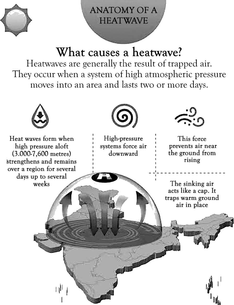
• Heat waves generally take place between March and June, though in rare instances, they may persist until July. This extreme rise in atmospheric temperature can cause physiological stress, which in severe cases may lead to fatalities.
•
As per the World Meteorological Organization, a heat wave is characterized by a stretch of at least five consecutive days where the maximum daily temperature surpasses the average maximum temperature by at least five degrees Celsius.
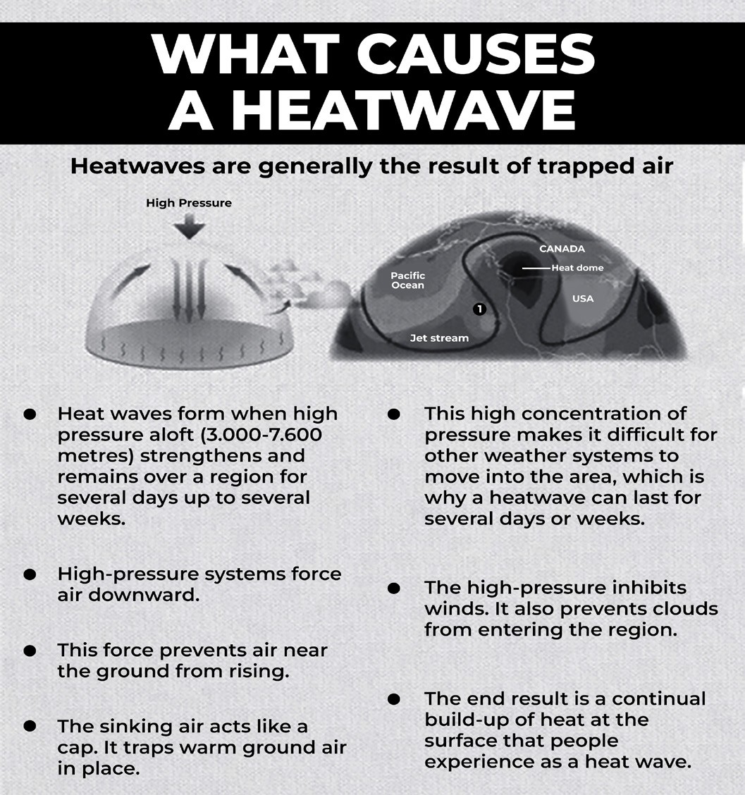
• The Indian Meteorological Department (IMD) has given the following criteria for Heat Waves:
• A heat wave is identified when the maximum temperature of a location reaches at least 40°C or more in plains, 37°C or higher in coastal areas, and a minimum of 30°C in hilly regions.
• If a location’s normal maximum temperature is 40°C or below, a heat wave is declared when the temperature deviates by 5°C to 6°C from normal
• Severe heat wave is recorded when the deviation reaches 7°C or more.
• If the normal maximum temperature exceeds 40°C, a heat wave is considered when the deviation is between 4 C and 5 C, whereas a severe heat wave occurs with a deviation of 6 C or more.
• Regardless of the normal maximum temperature, a heat wave is officially declared when the actual maximum temperature reaches or exceeds 45°C.
• The frequency, intensity, and duration of heat waves are increasing globally due to climate change, leading to more extreme daily peak temperatures.
Mechanism of Heat Wave Development
• Heatwaves are generally the result of trapped air. Heatwaves form when high pressure aloft (3000-7000) metres strengthens and remains over a region for several days up to several weeks.
High-pressure systems force air downward. This force prevents air near the ground from rising. The sinking air acts like a cap it traps warm ground air in place.
• This high concentration of pressure makes it difficult for other weather systems to move into the area which is why a
heatwave can last for several days or weeks.
• The high-pressure inhibits winds and also prevents clouds from entering the region
• The end result is a continual build-up of heat at the surface that people experience as a heat wave.
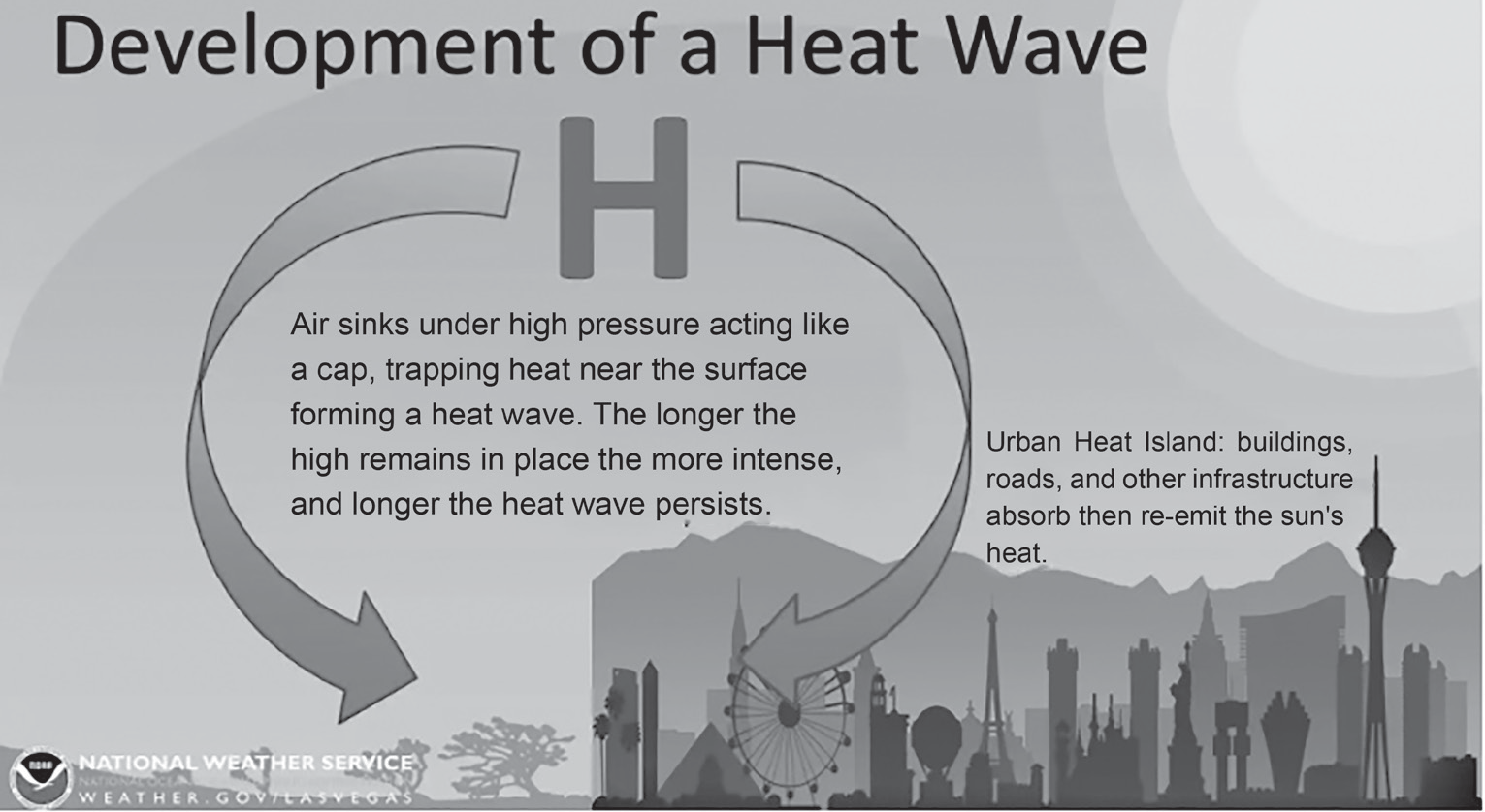
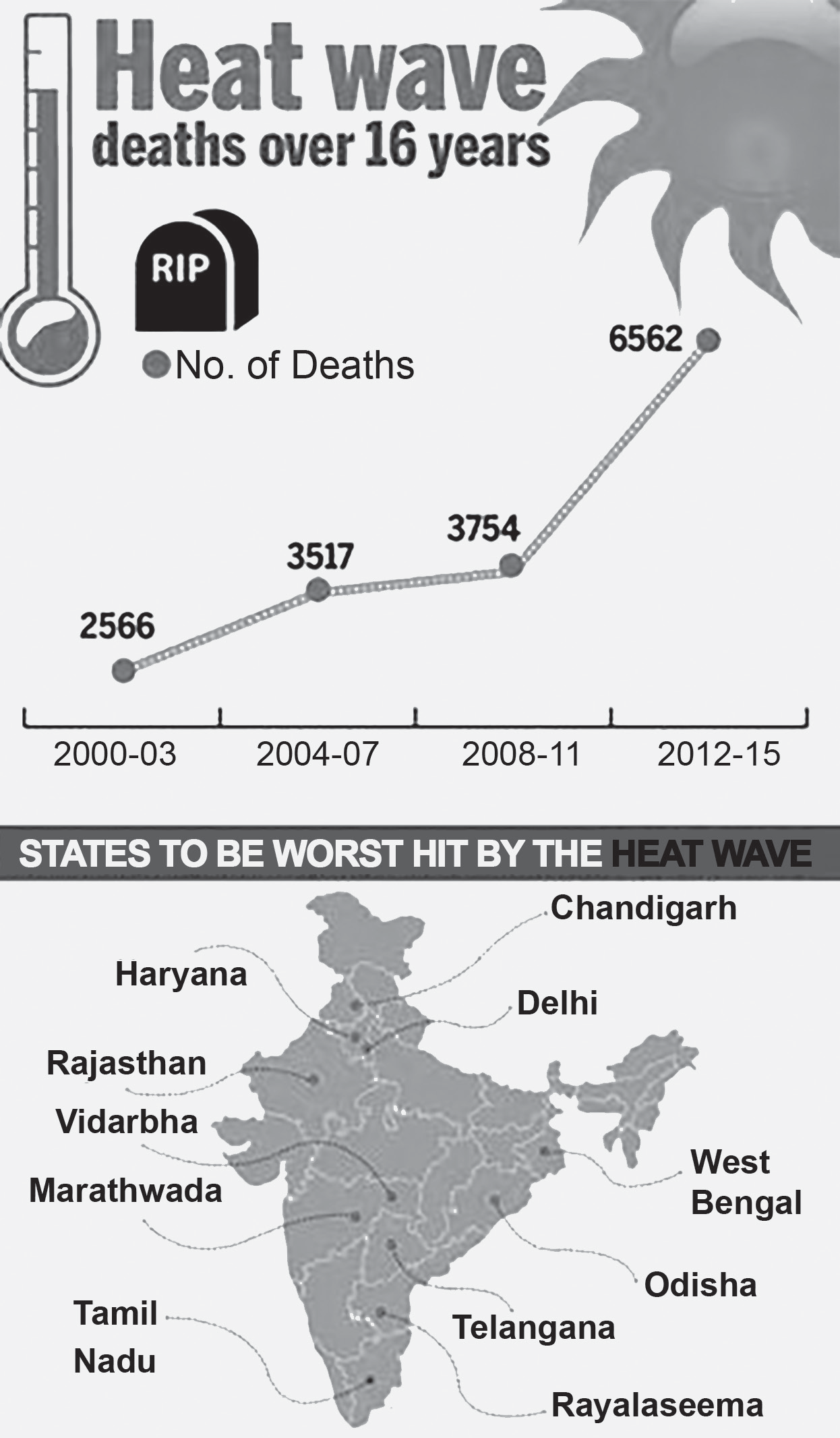
India too is feeling the impact of climate change in terms of increased instances of heat waves which are more intense in nature with each passing year, and have a devastating impact on human health thereby increasing the number of heat wave casualties. In India, the five most severe heatwave events have occurred after 1990.
Health Impacts of Heat Waves
The India Meteorological Department (IMD) has developed a Heat Index that categorizes heat levels using color codes: Green for temperatures below 35 C, Yellow for 36-45 C, Orange for 46-55 C, and Red for temperatures exceeding 55 C.
Health Effects of Heat Waves: Exposure to extreme heat can lead to various health issues such as dehydration, heat cramps, heat exhaustion, and heat stroke. The symptoms associated with these conditions are:
Heat Cramps: Swelling (edema) and fainting (syncope),
often occurring with a fever below 39 C (102 F).
Heat Exhaustion: Symptoms include fatigue, weakness, dizziness, headaches, nausea, vomiting, muscle cramps, and excessive sweating.
Heat Stroke: A life-threatening condition characterized by a body temperature of 40 C (104 F) or higher, along with symptoms such as confusion, seizures, or coma.
Heat Wave of 2023: Severe heat waves in Uttar Pradesh and Bihar resulted in nearly 100 fatalities.
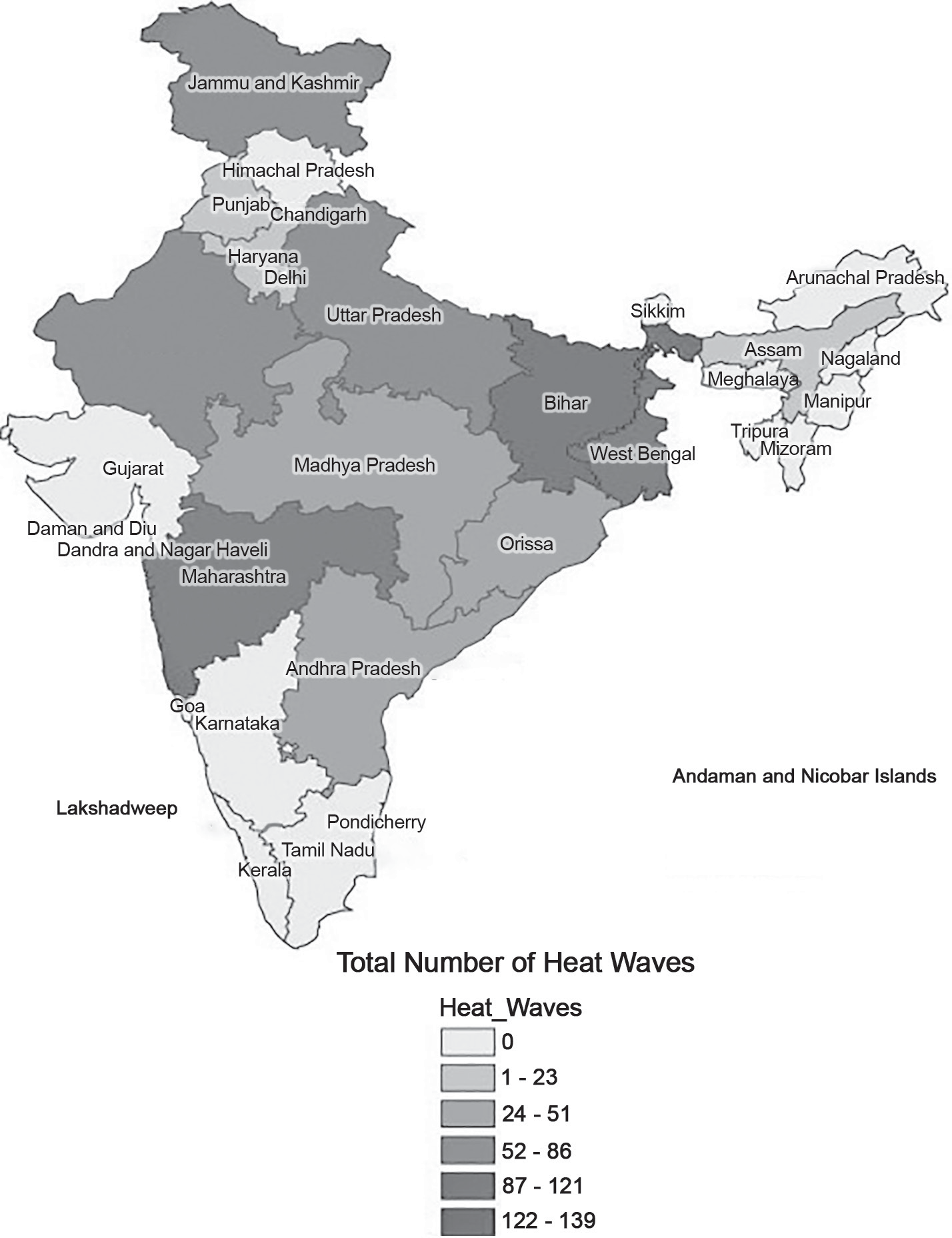
Map: Heat Wave Prone Areas of India
• Strengthening and maintaining monitoring and data
Heat-wave victims are the poor and vulnerable
The casualties of heat-wave conditions were mostly the poor and vulnerable in the unorganized sectors, such as daily-wage laborers, street hawkers, etc. They are compelled to work outdoors out of economic necessity, to earn their livelihood. Being unable to avoid the outdoors, they are particularly vulnerable to the dangers of heat-wave conditions.
Heat-waves mean tragedy and loss for both families and nation Heat-wave deaths and illnesses mean tragedy and loss, not only for the families of the victims, but also for the nation, for whom any avoidable loss of life is lamentable. Deaths and illness also mean productivity loss for the nation.
Mitigation Measures for Heat Wave
Mitigation Measures for Heat Wave Understanding Risk
• Vulnerability Assessment and Establishing Heat-Health Threshold Temperatures
logging systems for temperature, humidity, etc. required for threshold for heat wave alerts.
• Establish and maintain community -based network for sharing alerts
• Modify or customize warnings according to thresholds suitable for the State/UT
• Hazard Risk Vulnerability and Capacity Assessment (HRVCA)
• Create awareness preventive measures
• Specific messages for highly vulnerable groups such as elderly, young children, outdoor workers and slum residents
• Systematic data management on disaster damage and loss assessments
Inter-Agency Coordination
• Overall Disaster Governance
• Establishing and reinforcing the institutional framework, including designating a nodal agency and officials at various levels.
• Developing region-specific Heat Action Plans tailored to state or local requirements.
• Organizing response teams and enhancing coordination mechanisms for efficient management.
• Incorporating technical expertise and best practices from different regions for effective implementation.
• Partnering with NGOs to strengthen outreach and support efforts.
• Preparation and Response
• Managing and coordinating an immediate response to heatwave conditions.
• Collaborating with central agencies for effective action.
• Setting up First Aid and Medical Aid facilities at key locations.
• Identifying high-risk areas and ensuring access to drinking water at vulnerable sites and workplaces.
• Suspending outdoor sports and recreational activities during extreme heat.
• Ensuring livestock preparedness by providing adequate shade and water during hot weather.
• Establishing medical assistance points at locations with large gatherings.
• Implementing a Heat Alert System to facilitate early morning shifts for schools and offices, or rescheduling their timings during heatwave periods.
• Constructing cool shelters, shaded bus stands, and other infrastructure to provide relief from extreme heat.
Warnings, Information, Data
Coordinating the dissemination of warnings to all, down to the last mile – remote, rural or urban; Regular updates to people in areas at risk
Follow the alerts/warning
Collecting Data/Information necessary for review/ update of the plan
Investing in DRR – Structural Measures
Directive to promote cool roofs and heat reducing integrated development, passive cooling technology.
Guidelines and technical support for incorporation of protection from heat wave in Multi-Hazard Resistant Housing Schemes and Heat Wave Action Plan
• Hazard resistant construction, strengthening, and retrofitting of all lifeline structures and critical infrastructure.
Investing in DRR – Non-Structural Measures
• To reduce heatwaves, we will need to modify our urban planning standards and building bylaws to enhance green areas and water bodies and promote cool roofs and green buildings, among other things.
•
Techno -Legal regimes
• Laws and Regulations
• Institutional arrangements
• Improving the forest coverage and green areas
• Promote use of building materials that provide protection from heat
• Promote designs to reduce heat island effects in urban areas
• Facilitate integrated development plans that can cope better with heatwave conditions
• Implementationof Risk TransferArrangements
including multi-hazard insurance for life and property.
Capacity Development
• Train key officials regarding pre, during and post heat- wave season activities
• Training for deployment of Rapid Medical Response Teams
• Training on heat-wave specific health care for vulnerable groups
• Inclusion of heat wave and similar issues in various curriculum
• Promoting awareness, alertness and preparedness
• Promoting the planning and execution of emergency drills
• Promoting skill development for hazard resistant construction with emphasis on protection from heat in heat-wave prone areas for different types of housing and infrastructure.
• AHeat Code will outline the criteria for declaring heatwaves and will develop Standard Operating Procedures (SOPs) to be used during heatwaves, such as work-hour limits and relief measures in public places and hospitals. The heat code will also give the district administration the authority to declare an emergency, halt outdoor activities, and allocate resources for heat relief.
Heat Island Effect
Heat Island Effect
At nights, cities are often hotter than the suburbs or the countryside. They become ‘islands’ of higher temperature within a larger rural landscape, in a phenomenon called the Urban Heat Island Effect.
For smaller cities, heat islands are less noticeable. For a large city of one million people, the average temperature can be anywhere from around 1°C to 12°C warmer than the surrounding area.
There are three basic types of heat islands:
Canopy layer
Boundary layer
Surface
• Both Canopy Layer and Boundary Layer heat islands refer to atmospheric heating (warmer air temperatures).
• Surface Heat Islands refer to the actual temperature of surfaces in a specific heat island.
• Although the timing and intensity of these types may vary, they can all be harmful to urban and suburban environments.
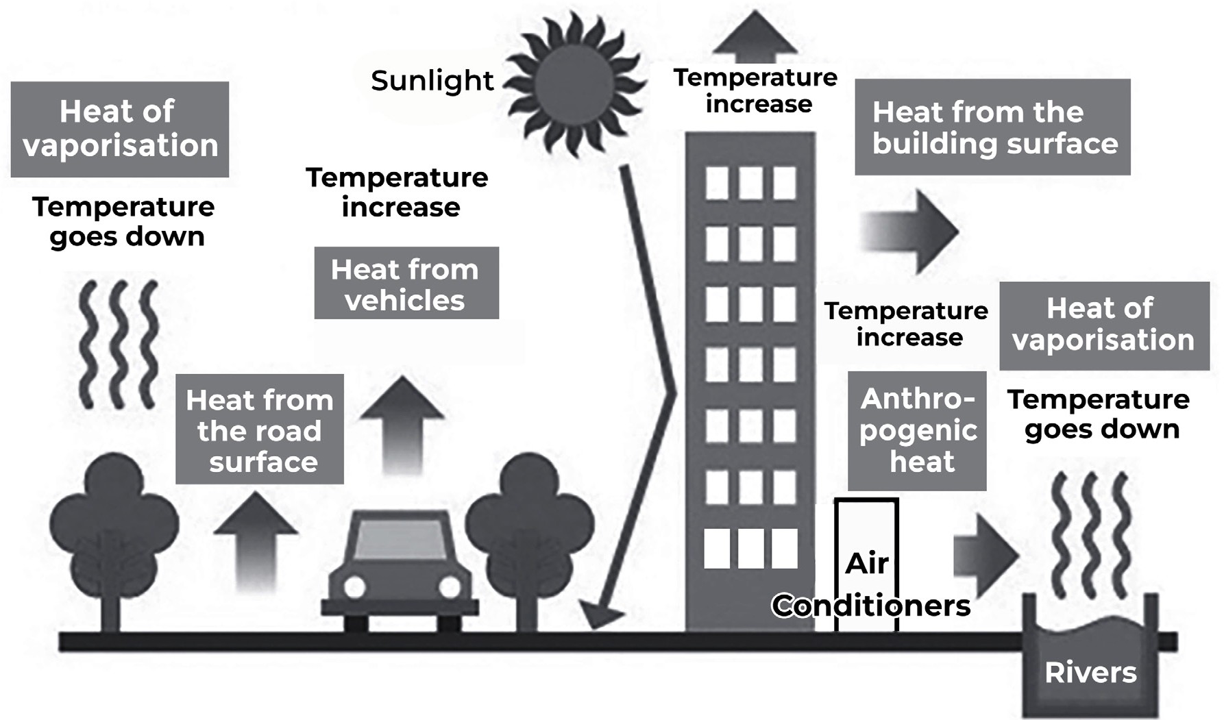
Figure: Heat Island Phenomena
• A 2020 study temperature data of 44 large Indian cities by IIT Kharagpur suggests that urban areas are taking longer to shed heat, despite having greenery in surrounding rural or suburban areas.
• There is a slow and consistent increase in the background temperature of cities– a signature of human-caused global warming and local climatic changes. Evidence from the study suggests that more green spaces within the city’s boundary could reduce the temperature in the city and outlying areas.
What Causes the Heat Island Effect?
• Loss of Vegetation and Surface: When urban and suburban areas lose land surface and naturally occurring vegetation, heat can no longer easily escape. Loss of tree cover in cities allows much less cooling of the area through evapotranspiration – a combination of evaporation (movement of water to air from surfaces such as soil, water bodies, etc.) and transpiration (movement of water through plant roots into the air via tiny pores in leaves called stomata).
• Geometric Effects: Buildings, especially tall ones, provide multiple surfaces that reflect and absorb heat from sunlight. In addition, multiple tall buildings in close proximity to each other also act as barriers to air flow and wind, which block cooling by convection. These two factors together lead to the Urban Canyon Or Street Canyon Effect, which blocks the loss of heat from ground surfaces through radiation.
• Dark Surfaces and Thermal Bulk Properties: Asphalt (roads) and concrete (most buildings) absorb much
more heat than surrounding rural areas. Concrete, which is has a very high heat capacity. In addition, atmospheric conditions above cities often lead to urban air being trapped near the ground surface, where it is heated by the warm urban surfaces.
• Anthropogenic Heat Generation and Air Pollution: Anthropogenic heat is produced by vehicles and buildings (through electric devices like fans, computers, refrigerators, and air conditioners), almost negligible in commercial and residential areas, yet high levels of air pollutants in cities, however, especially carbon dioxide and ozone, both of which are greenhouse gases, are thought to contribute significantly to the UHI effect.
• Waste heat from energy use is another source of additional heat.
• Other contributing factors include local weather, seasonal changes, time of day, and geographic location.
What are the Implications of Heat Islands?
• Heat islands are considered a form of local climate change as opposed to global climate change. The effects of heat islands are confined to specific areas.
• Of course, one of the most noticeable impacts on urban dwellers is an increase in hot, summer weather, inhabitants of larger cities will notice hotter and more uncomfortable temperatures. New York City has been called a “floating oven”.
• High use of air conditioners results in more heat being released into the air, this also contributes to air pollution, as more greenhouse gas emissions are discharged. This
negatively impacts air quality and can also lead to a
surge in urban smog.
• It can lead to problems such as asthma, increased spread of vector-born disease, heat stroke, and childhood obesity. The city of Toronto averages about 120 deaths per year. Heat Exhaustion, Heat Syncope (Fainting) and even death can occur among residents.
Mitigation of Heat Island Effect
• One popular technique for combatting the heat island effect is installing green roofs on urban buildings.
• Green roofs, which are lined with soil and certain types of vegetation, can actually help cities regain some of the cooling and evaporative effects that the natural landscape once provided.
• As this idea becomes more popular, there is more and more scientific evidence that green roofs can reduce heat in urban areas.
• Paint buildings with light or white colours that do not absorb nearly as much heat.
• Another rooftop technique is Roof Sprinkling. As moisture from the sprinklers evaporates, this helps to cools the surrounding air.
• Many cities have urban forestry initiatives like Green Ribbon technique of Toronto.
• Promoting the use of coatings with high reflectance and emittance (ability to emit absorbed heat quickly) to reduce heat absorption in buildings.
• Non-roof-based strategies:
• Focus on increasing vegetation cover in cities by planting trees in open areas (especially places such as parking lots which are usually asphalted).
• Promoting ‘green walls’ (vertical plant growth systems).
• Other ideas involve increasing numbers of water bodies, and the use of ‘climate-responsive’ architecture, using specific materials and ventilation techniques that promote passive cooling such as the Tube House in Ahmedabad.
Linkages between Heat Waves, Urban Heat Island Effect and El Nino
• Under the background of global warming, interaction between heat waves (HWs) and urban heat island (UHI) has led to trends of increase in the intensity, frequency, and duration of extreme heat events in urban areas, seriously threatening the health of urban populations.
• This effect increases energy costs (e.g., for air conditioning), air pollution levels, and heat-related illness and mortality.
• While both urban and rural dwellers are affected by heat waves, typically, temperatures in cities can be 5-8 C higher than those in surrounding rural areas due to this.
• Another factor of El Niño will greatly increase the likelihood
of breaking temperature records and triggering more
extreme heat in many parts of the world and in the ocean.
Steps Taken for Heat Waves
• Fortunately, many cities and states have acknowledged the threat and developed Heat Action Plans (HAPs). For example, in 2013, Ahmedabad became the first city to implement a HAP to raise public awareness, identify high-risk groups, issue heatwave alerts, and improve inter-agency collaboration. So far, 30-odd cities have adopted similar HAPs.
• State-wide HAPs have also been introduced in Delhi,
Tamil Nadu, Kerala, Maharashtra, and Odisha.
• In 2015, Government of India declared heatwave a natural disaster under the National Disaster Management Act of 2005.
• As a result, while the heatwave is qualified for support from the National and State Disaster Response and Mitigation Funds.
• However, there are insufficient resources and capacity to enhance resilience in cities and states.
• Also nationally, the overall effort remains grossly inadequate.
• Our existing building codes and urban planning are not intended to keep our cities cool. On the contrary, they are worsening heatwaves by magnifying the Heat Island Effect.
• Fortunately, many cities and states have acknowledged the threat and developed Heat Action Plans (HAPs). For example, in 2013, Ahmedabad became the first city to implement a HAP to raise public awareness, identify high-risk groups, issue heatwave alerts, and improve inter-agency collaboration. So far, 30-odd cities have adopted similar HAPs.
• State-wide HAPs have also been introduced in Tamil
Nadu, Kerala, Maharashtra, and Odisha.
• In 2015, Government of India declared heatwave a natural disaster under the National Disaster Management Act of 2005.
• As a result, while the heatwave is qualified for support from the National and State Disaster Response and Mitigation Funds.
• However, there are insufficient resources and capacity to enhance resilience in cities and states.
• Also nationally, the overall effort remains grossly inadequate.
• Our existing building codes and urban planning are not intended to keep our cities cool. On the contrary, they are worsening heatwaves by magnifying the Heat Island Effect.
• The Ministry of Health and Family Welfare has taken steps to increase public awareness on the subject of health impacts of climate change including heat waves, under the ‘National Programme on Climate Change and Human Health’.
Cold Wave and Frost
Cold Wave and Frost
• Cold waves and frost are seasonal, localized hazards that affect specific regions of the country experiencing harsh winters. Frost occurs when ice crystals form on surfaces due to a prolonged drop in nighttime temperatures.
• The northern parts of India, particularly the hilly areas and nearby plains, are impacted by transient disturbances in the mid-latitude westerlies, commonly known as Western Disturbances, which often exhibit weak frontal characteristics.
• Cold waves primarily impact regions north of 20°N, but under large amplitude trough conditions, states likeMaharashtra and Karnataka have also reported cold wave occurrences.
• The vulnerability of crops to frost varies significantly, and the severity of damage depends on temperature, duration of exposure, humidity levels, and the rate at which freezing temperatures are reached.
• Uttar Pradesh recorded the highest number of cold wave-related deaths, with 5,023 fatalities, accounting for 26% of such deaths in India between 1995 and 2020. Bihar and Punjab also reported significant loss of human lives due to cold waves.
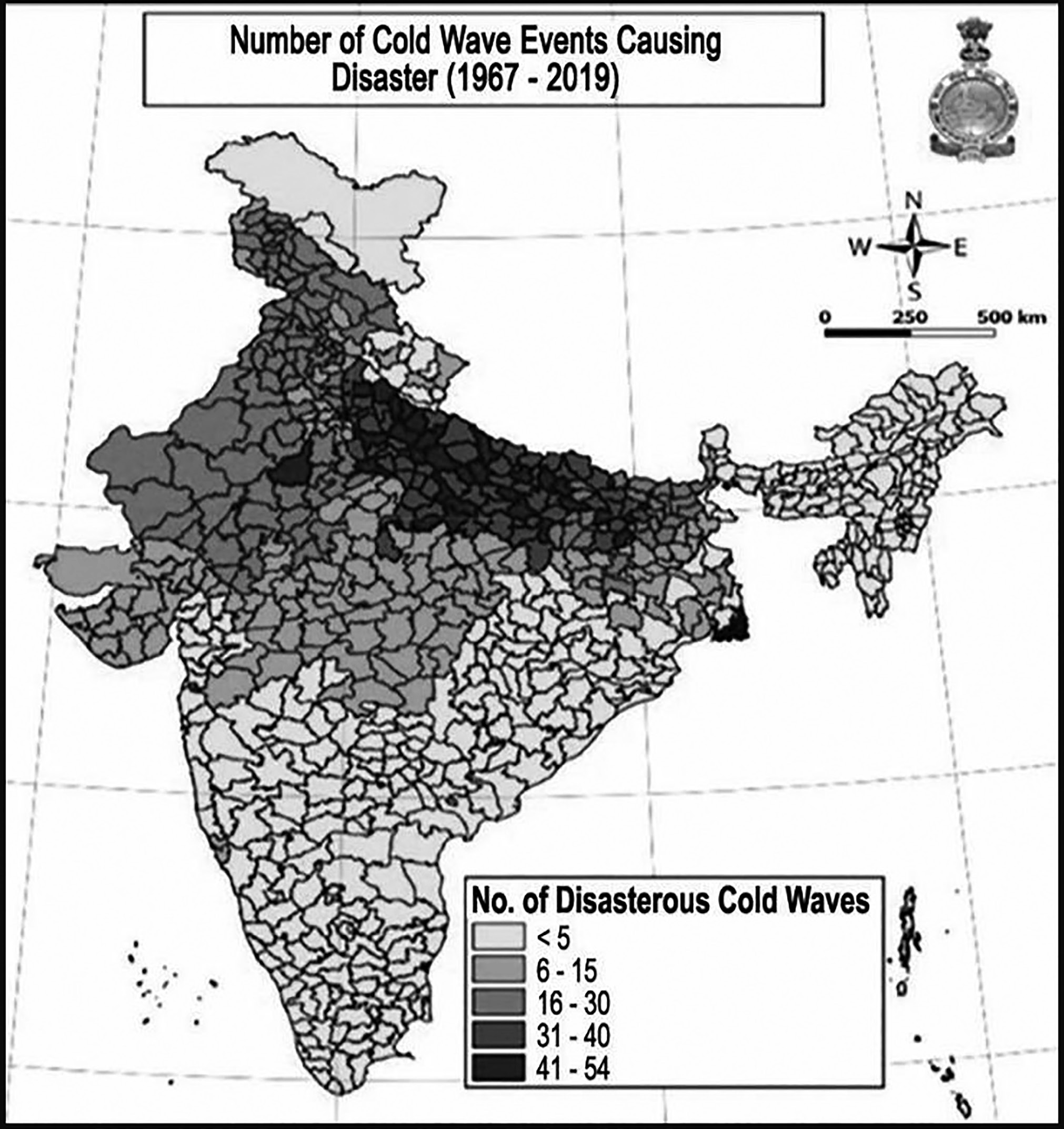
Map: Cold Wave Disaster in India
Definition
Cold Wave Classification: Cold waves are determined based on the actual minimum temperature recorded at a location. A cold wave is considered when the minimum temperature is 10°C or below in plains and 0°C or lower in hilly areas.
Classification Based on Departure from Normal Temperature:
• Cold Wave (CW): When the temperature falls 4.5°C to 6.4°C below normal.
• Severe Cold Wave (SCW): When the temperature drops more than 6.4°C below normal.
Classification Based on Actual Minimum Temperature (For Plains Only):
• Cold Wave: Minimum temperature is ≤ 4°C.
• Severe Cold Wave: Minimum temperature is ≤ 2°C.
• For coastal regions, a cold wave is declared when the minimum temperature is 15°C or lower with a departure of -4.5°C or more from normal.
Cold Day Classification:
• A cold day occurs when the minimum temperature is 10°C or lower in plains and 0°C or lower in hilly regions.
• Cold Day: Maximum temperature falls 4.5°C to 6.4°C below normal.
• Severe Cold Day: Maximum temperature drops more than 6.4°C below normal.
Impact on Plants:
• Light Freeze (-1.7°C to 0.1°C): Kills tender plants
with minimal damage to other vegetation.
• Moderate Freeze (-3.9°C to -2.2°C): Causes extensive damage to most vegetation, including fruit blossoms and semi-hardy plants.
• Severe Freeze (-4.4°C and below): Leads to significant harm to almost all plants. The ground freezes solid, with the depth of frozen soil depending on freeze intensity, duration, soil moisture, and type.
Causes of Cold Waves
Pressure Differences: A “protracted area of relatively high atmospheric pressure” in the jet stream in northwest can cause cold waves in north and central India.
Cloud cover: The lack of cloud cover can result in a cold wave. Clouds play a major role in trapping infrared radiation from the Earth. When there is a limited cloud cover, more heat escapes causing the temperature to fall on the surface and the atmosphere.
Wind and Moisture Content: Large parts of the Indo gangetic plains have been covered in a layer of fog due to light wind and high moisture levels near to the land’s surface.
Large-scale Fog Cover: Long-lasting fog interferes with the balance of radiation by blocking sunlight from reaching the surface. Light winds and high moisture near
the land surface have been contributing to the formation of a blanket of fog over large swathes of the Indo-Gangetic plains in the morning.
Westerly: westerly and northwesterly winds of around 5 to 10 km/h in the afternoon have also been contributing to the dip in temperature.
During La Nina, the warm water on the surface are blown towards Indonesia. This results in cold water raising to the surface of the Pacific Ocean. this causes a cooling effect.
Non-seasonal or non-monsoon rainfall, which becoming a common phenomenon due to the growing climate crisis, is one of the contributing factors for cold waves in North India. There is a decline in monsoon rainfall and an increase in non-seasonal rainfall.
Climate change is related to a global increase in temperatures and extreme weather events, including cold waves and other extreme cold weather events.
• In 2023, Meteorologists attribute the long spell of intense cold to a long gap between two western disturbances, which meant frosty winds from the snow-clad mountains blew for a longer period.
Hazard, Vulnerability and Risk Analysis
• Hazard Assessment: Given India's vast geographical diversity, the country is susceptible to various natural disasters such as earthquakes, landslides, tsunamis, avalanches, glacial lake outburst floods (GLOFs), floods, cold waves, wildfires, and cyclones. The northern regions, particularly along the Himalayas and western desert areas, frequently experience cold waves. Climate change has further intensified these weather-related hazards.
• As per IMD 17 states and union territories fall under India's Core Cold Wave Zone (CCZ), impacting a total population of 90.90 crores.
• 24.28 crore people within this region are especially vulnerable due to their age (below 10 years or above 60 years). This includes 17.9 crore from rural areas and 6.38 crore from urban regions. The states under CCZ include Punjab, Himachal Pradesh, Uttarakhand, Jammu & Kashmir, Ladakh, Delhi, Haryana, Rajasthan, Uttar Pradesh, Gujarat, Madhya Pradesh, Chhattisgarh, Bihar, Jharkhand, West Bengal, Odisha, and Telangana.
• The highest occurrences of cold waves are recorded in Jammu & Kashmir, followed by Himachal Pradesh, Punjab, Bihar, Haryana, and Uttar Pradesh. Authorities in CCZ states should analyze cold wave and severe cold wave durations and establish Standard Operating Procedures (SOPs) to minimize adverse effects.
• The India Meteorological Department (IMD) provides forecasts and warnings before the cold wave season. If state or district authorities lack technical expertise for Hazard, Vulnerability, and Risk Assessment (HVRA), they can request IMD to conduct a detailed analysis of their region.
• Vulnerability Analysis: The impact of hazard events such as cold waves, extreme cold waves, rainfall, snowfall, is substantial and represents an increasing threat over India. The extent of vulnerability (mild, moderate or intensive) and the probable cost of damages to agriculture including animal husbandry due to cold wave of varying intensities must be included in the assessment report. Apart from the agriculture sector, many other sectors get affected due to cold waves.
• When it comes to economic sectors that are vulnerable to cold wave and related hazards; agriculture, animal husbandry and health are of primary importance.
• Human health is also vulnerable to the temperature drop. State Governments can identify the population in each district/village that are in the vulnerable groups. Population below 6 years and above 60 years can be notified as vulnerable to cold wave and can be made beneficiaries to schemes designed for mitigating cold wave risk.
• Apart from the age groups, care needs to be taken to include people with disabilities, female-headed households, people under psycho-social care, people needing regular medication, etc. Workers who engage in economic activities in open areas need to be considered while disseminating the warnings. Similarly, sellers operating hand/push carts, open to sky shops/markets, also need to be included in the vulnerable groups. Includes informal selling points of vegetables, fruits, other consumables on push-cart, etc.
• Cold waves may also impact the efficiency and operation of other infrastructure like IoT, Energy/ Power, IT/Communications, Transportation,
Banking & Finance, Government Services, Emergency Services, Water Supply/Management, Food production/security, etc.
Colour Code Early Warning System for Cold Waves
Assessment of each these sector’s exposure to cold waves may be conducted. Action Plan and Standard Operating Procedures need to be prepared in order to minimise the impacts of cold waves and improve business continuity.
Impact on each of these sectors will be different and SOPs need to be customised to suit the sector’s needs.
Transport sector in general and aviation sector in particular are prone to delays and stoppage due to low visibility caused by fog/smog.
• Risk Analysis for Cold Wave: With respect to a disaster, risk is specifically described using relative terms such as high-risk, average-risk and low-risk to indicate the degree of probability of the occurrence of the incident. The risk assessment includes an evaluation of all elements that are relevant to the understanding of the existing hazards and their effects on a specific environment.
• There are several steps in risk assessment based on the related processes of hazard mapping and vulnerability analysis. They establish the nature, location and scale of risks to society and its assets. This information can assist decision makers in deciding what can and should be protected and up to which level.
• Risk prone population of cold waves can be assessed by counting the population in the vulnerable age groups, homeless, people with disabilities, etc., in the cold wave exposed districts.
• Information from the Census of India can be considered for arriving at this number.
• Apart from this, people enlisted in the Below-Poverty- Line (BPL) population, beneficiaries of various other social schemes (both States and Centre) can also be considered as at-risk population.
• People engaged in the vulnerable economic sectors need to be enlisted and provided information on remedial measures.
| Colour Code | Alert | Warnings | Impact | Suggested Action |
| Green (No Action) | Normal day | Comfortable temperature. | Minimum temperatures are near normal. | No precautionary action required. |
| Yellow Alert (Be Updated) | Cold Wave Alert | Cold wave conditions in isolated areas persist for two days. | Moderate temperature. Chilly winds may aggravate cold at time. Cold is tolerable but mild health concern for vulnerable people. (Infants, pregnant women, elderly, people with chronic diseases etc. | Avoid prolonged exposure to cold. Wear several layers of loose fitting, light weight; warm woolen clothing rather than one layer of heavy cloth. Cover your head, neck, hands and toes adequately as majority of heat loss occurs through these body parts. |
| Orange Alert (Be Prepared) | Severe Cold Wave Alert | Severe cold wave conditions persist for two days. Though not severe, cold wave conditions persist for four days or more. | Prolonged exposure to cold increases the risk of illnesses such as flu, a runny or congested nose, and nosebleeds, which may develop or worsen in extreme cold conditions. Never ignore shivering, as it is the first indication that the body is losing heat. Seek shelter indoors immediately. Extended exposure to cold can lead to frostbite, causing the skin to become pale, hard, and numb, eventually forming black blisters on exposed areas like fingers, toes, nose, and earlobes. Severe frostbite requires urgent medical care and treatment. | Stay informed about weather conditions by listening to the radio, watching TV, or reading newspapers for forecasts and updates. Wear insulated and waterproof footwear. Keep your skin moisturized using oil, petroleum jelly, or body cream. Consume nutritious fruits and vegetables rich in vitamin C and stay hydrated to support immunity. Minimize outdoor activities and keep yourself dry. If your clothes get wet, change them immediately to prevent heat loss. Gradually warm affected body areas using lukewarm water. If the skin turns black, seek medical attention immediately. Ensure proper ventilation while using heaters to prevent inhalation of toxic fumes. Avoid alcohol consumption as it lowers body temperature. Instead, drink hot beverages regularly to stay warm. |
| Red Alert (Take Action) | Severe cold wave conditions persist for more than two days. Total number of cold wave/ severe cold wave/days exceeding six days. | Prolonged exposure to extreme cold can result in hypothermia, a condition where the body temperature drops significantly. Symptoms includeconfusion, shivering,slurred speech, drowsiness, muscle stiffness, labored breathing, weakness, and possible loss of consciousness. Hypothermia is a critical medical emergency requiring immediate attention. Frost and cold waves have adverse effects on pulse crops and livestock. | In addition to the recommended measures for an orange alert, extra caution should be taken for vulnerable individuals. Regularly check on elderly neighbors, particularly those living alone. Stay indoors whenever possible and avoid unnecessary physical exertion. Identify the nearest designated public shelter. If there is a failure in electricity or heating systems, relocate affected individuals to these shelters. If someone is experiencing frostbite or hypothermia, seek medical help immediately. Do not offer fluids to the affected person unless they are fully conscious. Store sufficient water, as pipes may freeze due to extreme cold. Bring pets indoors and ensure livestock or large animals are protected from the cold by sheltering them in enclosed spaces. |
Impact of Cold Waves
• An increase in the body's caloric requirements and the risk of hypothermia in humans.
• Fatalities and injuries, including crop failures and the death of plants, livestock, and wildlife.
• Fisheries: Harsh climatic conditions, especially during winter when air temperatures fall to 2-4 C and water temperatures range between 10-15 C, negatively impact the growth of Indian major carps.
• Transport: Extreme cold weather or cold waves impact the transport sector, including airways, river and seaports, roadways, railways, and local transportation.
• Energy or Power: The energy sector experiences immense pressure during severe winter or cold waves, as energy consumption increases significantly.
• Water: Extremely low temperatures lead to water freezing, directly affecting the water sector. This can result in disruptions in water supply.
• Besides causing severe health issues, cold waves also lead to disruptions in essential services, infrastructure, power, and supplies.
Mitigation Measures for People
Mitigation Measures for People
• The State Governments must maintain close coordination with India Meteorological Department (IMD) and closely monitor cold wave situations through Cold Index to measure cold discomfort. Warnings should be disseminated to the public through appropriate forums (including local newspapers and radio stations) on a regular basis.
• Cold Wave Forecast and Prediction is done by Indian Metrological Department on the basis of:
• Synoptic Analysis
• Climatological Analysis
• Dynamic Statistical Techniques
• Consensus model made from various Global Numerical Prediction Models.
• Weather Research and Forecasting (WRF Model) based on Meteorological & Oceanographic Satellite Data Archival Centre from Space Applications Centre, ISRO.
• Precaution measures to be followed are as follows:
• Stay indoors as much as possible to minimize exposure to the cold.
• Tune in to local radio stations for the latest weather updates.
• Consume nutritious food to help maintain body heat and drink non-alcoholic fluids to prevent dehydration.
• Dress in multiple layers of light, warm clothing instead of a single heavy layer. The outerwear should be tightly woven and water-resistant.
• Keep yourself dry and change wet clothes immediately
to avoid losing body heat.
• Ensure proper ventilation when using kerosene heaters or coal ovens to prevent inhalation of toxic fumes.
• If heating arrangements are unavailable, seek shelter in public places where the administration provides heating facilities.
•
Cover your head to prevent heat loss and protect your lungs by covering your mouth.
• Avoid excessive physical exertion, as overworking can increase the risk of a heart attack.
• Be alert for signs of frostbite, such as numbness and pale or white skin on the fingers, toes, earlobes, and nose tip.
• Watch for hypothermia symptoms, including uncontrolled shivering, confusion, memory loss, slurred speech, drowsiness, and extreme exhaustion. Seek immediate medical attention at the nearest hospital.
• Stockpile essential supplies such as food and water before a cold wave occurs.
• Ensure hospitals are prepared to handle patients suffering from frostbite and hypothermia.
Mitigation Measures for Crops and Animals
Farmers should provide light irrigation as needed, promptly trim damaged branch tips or shoots, burn leaves and waste materials in orchards to generate smoke, and aid crop recovery by pruning dead plant material and applying additional fertilizer through foliar sprays.
Spraying vulnerable crops with water can paradoxically shield them by freezing, which absorbs cold from the surrounding air.
Animal care organizations should offer guidance and necessary assistance to ensure the well-being and protection of animals.
During cold wave conditions, livestock owners must provide adequate nutrition with suitable feed to prevent animal fatalities. They should stockpile sufficient feed or forage in advance and prevent animals from exposure to extreme cold.
Using locally available organic mulches for thermal insulation can slow down soil cooling and help maintain soil warmth.
• Running fans in orchards can facilitate air circulation, disrupting inversion layers and allowing cold and warm air to mix freely.
• Generating heat using heaters or fires between crop rows and producing smoke by burning dried weeds or wood in orchards can create an insulating air blanket. This helps trap outgoing long-wave radiation, significantly reducing temperature drops (greenhouse effect).
• Sprinkler irrigation can help release latent heat of fusion, warming the surrounding air through the condensation of water droplets.
• Encouraging the cultivation of cold- and frost-resistant crops or plant varieties in frost-prone regions can help minimize agricultural losses.
• The use of growth regulators and chemical applications to enhance plant resistance to cold stress may also be beneficial.
• Establishing windbreaks or shelter belts around orchards in regions prone to cold waves can help reduce
wind speeds and the chilling effect on the leeward side while also minimizing heat loss from protected crops.
• Practicing mixed cropping by interplanting vegetables like tomato and brinjal with taller crops such as mustard or pigeon pea can serve as a natural barrier against cold winds.
• Implementing agronomic techniques such as raising nurseries under partial tree shade or between tree rows, adopting multi-story or mixed plantations, and pruning unnecessary twigs or branches for use as mulch can provide insulation. Additionally, plant cover shade offers significant protection through the greenhouse effect.
Steps Taken to Mitigate Cold Wave in India
• Considering the importance of cold wave, the Government of India notified ‘cold wave’ as a disaster and the Ministry of Agriculture as the nodal Ministry.
• National Guidelines for Preparation of Action plan - Prevention and Management of Cold Wave and Frost by NDMA.
• Timely Warning and Colour Coded system of Indicators have been developed for dissemination among the people by Indian Metrological Department (IMD).
Droughts and Desertification
Droughts and Desertification
• Drought is a temporary decline in water or moisture availability, falling significantly below the normal or expected levels for a specific duration.
• It occurs due to insufficient rainfall or a lack of irrigation infrastructure.
• Most countries experience drought conditions.
• Drought is often accompanied by other climatic factors such as strong winds, high temperatures, and low relative humidity, which can intensify its severity.
• According to the Indian Meteorological Department (IMD), drought results from a prolonged natural decrease in precipitation.
• As stated in the Manual for Drought Management 2016,
drought is determined based on two key indicators:
• The degree of rainfall deficiency.
• The resulting dry spell.
• The western and southern regions are highly susceptible to drought, while the northern and central areas experience comparatively lesser impact.

Map: Flash Floods in India
• India’s irrigation system largely depends on monsoon rainfall. An unpredictable pattern, with both low (below 750 mm) and medium (750-1125 mm) rainfall, makes 68% of the total land area vulnerable to recurring droughts.
• A century-long analysis indicates that arid, semi-arid, and sub-humid regions experience below-normal rainfall 54-57% of the time. Severe and infrequent droughts occur in arid and semi-arid areas approximately every 8-9 years.
• Around 50% of severe droughts occur in semi-arid and arid zones, typically affecting about 76% of the area. In this region, the most extreme droughts have been recorded approximately once in 32 years, with nearly every third year experiencing drought conditions.
Drought Prone Areas in India
• Extreme Drought-Affected Areas: The most affected regions include large parts of Rajasthan, particularly
areas west of the Aravali Hills, such as Marusthali and the Kachchh region of Gujarat. Districts like Jaisalmer and Barmer, located in the Indian desert, fall into this category, receiving an average annual rainfall of less than 90 mm.
• Severe Drought-Prone Areas: This includes eastern Rajasthan, most of Madhya Pradesh, eastern Maharashtra, interior regions of Andhra Pradesh and the Karnataka Plateau, northern parts of interior Tamil Nadu, and southern regions of Jharkhand and interior Odisha.
• Moderate Drought-Affected Areas: The northern regions of Rajasthan, Haryana, and southern districts of Uttar Pradesh, along with the remaining parts of Gujarat, most of Maharashtra (excluding Konkan), Jharkhand, the Coimbatore Plateau in Tamil Nadu, and interior Karnataka, fall under this category.
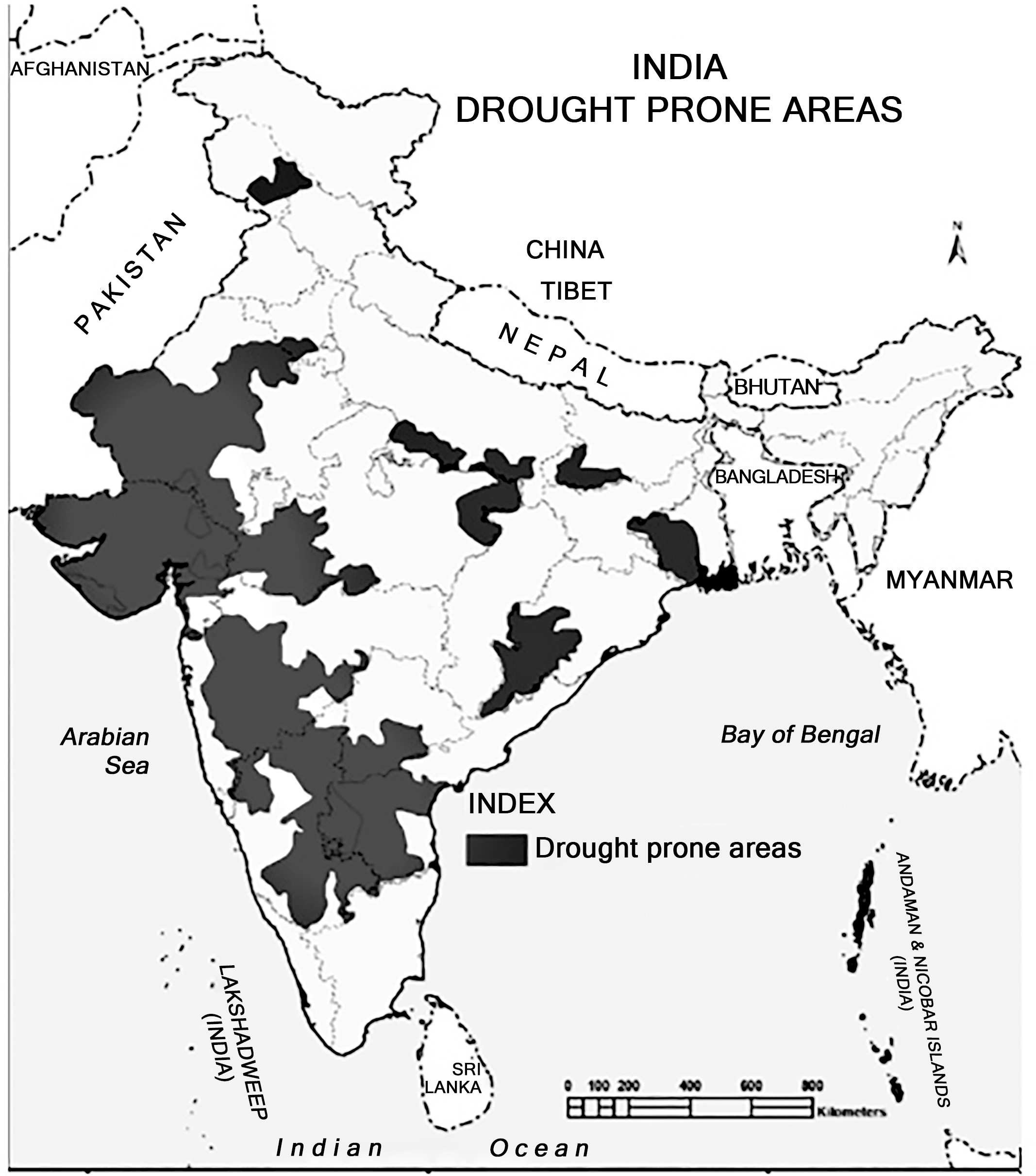
Map: Drought Prone Areas of India
Types of Droughts
Drought can be classified into following major categories:
• Meteorological Drought: This occurs when rainfall drops below a specific threshold (long-term average for a particular period, such as days, months, a season, or a year). It is the least severe form of drought and results
from an unexpected decline in precipitation.
• Hydrological Drought: This refers to a decline in water resources, including stream flow, lake levels, groundwater, and underground aquifers, below a specified level for a given duration. It is caused by a
significant reduction in natural water flow, groundwater
levels, and the depletion of stored water in reservoirs and lakes used for water supply.
• Agricultural Drought: This occurs when soil moisture is inadequate to support normal crop growth and yields. It results from an imbalance between soil moisture availability and the evapotranspiration needs of crops over an extended period, leading to damage to standing crops and reduced harvests.
• Ecological Drought: This happens when a lack of water reduces the productivity of a natural ecosystem, leading to ecological distress and damage to the environment.
• Flash Drought: This is a sudden or rapidly intensifying drought triggered by below-average precipitation, coupled with unusually high temperatures, strong winds, and increased radiation.
• A study published in the journal Science reported that climate change is intensifying flash droughts worldwide.
• In the last 64 years, more than 74% of the world’s regions identified by the U.N. Intergovernmental Panel on Climate Change’s ‘Special Report on Extreme Events’ have experienced flash droughts.
• It can also be linked to climatic patterns like La Niña.
• Flash droughts may lead to irreversible changes in terrestrial ecosystems. In such conditions, ecosystems may not have enough time to adapt to a large water deficit and extreme heat, leading to lower productivity.
• Flash droughts can also significantly challenge drought monitoring and prediction.
• The top five flash droughts based on the overall severity score occurred in 1979 followed by 2009,1951,1986 and 2005.
Identifying Drought
• The Indian Meteorological Department defines ‘drought’ as a situation occurring in any area where the annual rainfall is less than 75% of the normal rainfall. Besides evident shrinkage of water resources, crop failure and health problems, other symptoms are possible warning signs:
• Reduction in money lending
•
Unusual movement of flocks and herds in search of pasture
• Unusual migration
• Rapid rise in price of daily food
• Remarkable decrease in train travel and festival attendance
• Abnormal unemployment
• Abnormal variation in liquor consumption
• Abnormal sale of family jewellery at inadequate prices
• Droughts themselves do not cause desertification. They are common in arid and semi-arid areas and can be recovered from when rain returns if they are well- managed.
• It is a myth that people die of thirst during a drought. Deaths are caused by acute malnutrition since crops fail and livestock die.
• Famine is the “triple failure” of (1) food production,
(2) people’s ability to access food and, finally and most crucially (3) in the political response.
• Crop failure and poverty leave people vulnerable to starvation. The severe and widespread shortage of food results in large-scale starvation, malnourishment and death. It leads to disease outbreaks and economic and social collapse of the community.
• Drought is one of the causes that lead to famine. However, famines are presently uncommon in India.
Causes of Drought
Drought can occur due to various factors, with some of the primary causes being:
• Monsoon Variability: The failure or irregular pattern of monsoon rainfall can exert significant pressure on water availability, potentially leading to drought-like conditions.
• Excessive Use of Surface and Groundwater: Insufficient water conservation measures can result in a significant reduction in water availability, especially during summer months, increasing the likelihood of drought.
• Shifts in Agricultural Practices: Transitioning from crops with low to moderate water requirements to those with high water demand can significantly increase water consumption. This puts stress on limited irrigation infrastructure and available water resources, contributing to drought conditions.
• Overuse and Mismanagement of Water Resources: Unsustainable utilization and inefficient management of water for residential and agricultural purposes can also lead to water scarcity and drought-like situations.
Impacts of Drought:
Drought leads to significant challenges in affected areas, and its impacts can be categorized as follows:
• Environmental Impact: Water scarcity for drinking, irrigation, and other essential uses causes severe distress, not only for human communities but also for forests and aquatic ecosystems.
• Economic Impact: Drought has a major economic impact on affected communities, leading to loss of employment and livelihoods, rising prices of food and fodder, declining wages in both agricultural and non-agricultural sectors, and financial losses in dairy, fisheries, and other livestock industries.
• Social Impact: Drought exerts immense pressure on the social structure of society, resulting in:
• Migration in search of alternative livelihoods, leading to the breakdown of families and communities.
• Loss of human life due to heat stress, starvation, suicides, and unhygienic living conditions.
Distress sales of movable and immovable assets.
Widening social inequality.
Increased conflicts, including disputes over water usage, political tensions, and other societal conflicts.
Adverse effects on nutritional levels.
Rising mental and physical stress, including anxiety, depression, domestic violence, and other health issues.
Higher crime rates.
Certain sections of the population struggling to afford rising food prices, leading to a shift towards cheaper, lower-quality food and reduced overall food consumption.
Reduced school attendance as children lack energy or funds for education, resulting in increased child labor.
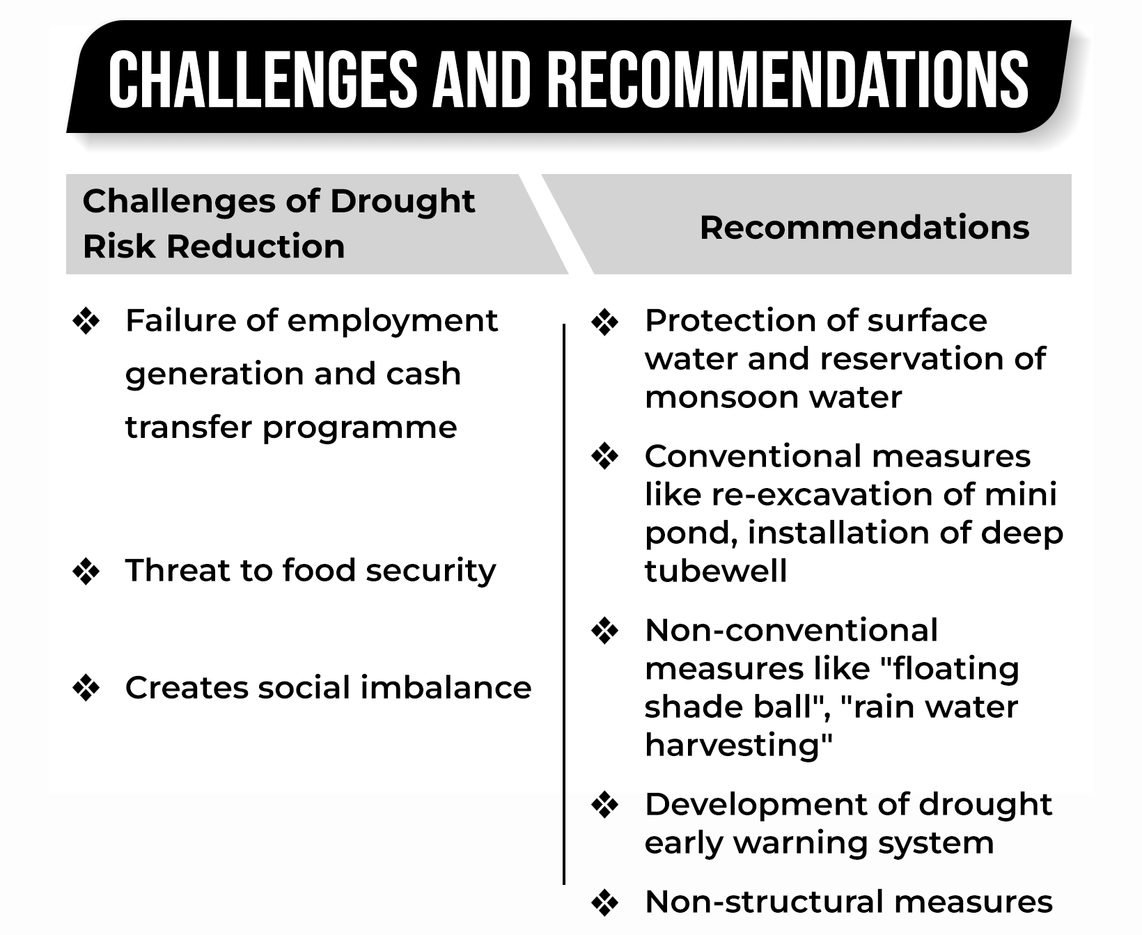
Drought Risk Mitigation Understanding Risk
Drought Risk Mitigation Understanding Risk
Vulnerability Maps
Block-wise rainfall deficit maps for the blocks with deficient rainfall – at crucial stages of the SW monsoon (early,
middle, and end) separately for NE monsoon
Comprehensive assessment of water deficit in dryland farming, rainfed, and drought-prone areas every year, at the end of the SW and NE monsoons
Agro-climatic region wise water deficit assessment reports for relevant regions separately at the end of SW and NE monsoon
Provide technical assistance to the State Govt./SDMC to prepare vulnerability maps
Analysis of satellite images, use of appropriate indicators
• Assessment, Monitoring, and Early Warning
• Improve the drought forecast, and assessment of water deficit in the arid/semi-arid, drought-prone, and dryland farming areas.
• Prepare detailed advisories on water conservation and crop management measures based on drought and water deficit in consultation with experts for each State/UT which is likely to face acute water deficit.
• Monitoring key drought indices at National and State levels
• Developing composite index of various drought indicators relevant to each agro-climatic zone.
• Develop a multi-criteria method based on various indices (vegetation, soil, water availability, etc.) as standardized framework for drought forecasting taking into account agro-climatic zones
• Drought Declaration
• Improve the criteria and method used for assessment of drought condition and key indicators for declaring drought
• Collaborate with State Government and its agencies for monitoring/ declaration of drought
• Hazard Risk Vulnerability Assessment
• Promote studies/provide guidelines on vulnerability assessment covering social, economic, ecological, gender, and equity aspects
• Study change in vulnerability and risk under climate change scenarios
• Research
• Agricultural research focussed on drought-prone areas, arid/semi-arid tracts, and dryland farming areas
• Research related to water conservation and management
Inter-Agency Coordination
Inter-agency coordination is a key component of strengthening disaster risk governance. It is required among both central and state agencies in the field of Overall disaster governance, Response, Warnings, Information and data sharing and Non- structural measures.
Investing in DRR - Structural Measures
• Storage Facilities
• Technical support for water conservation structures, integrated water resources management infrastructure needs (surface and groundwater)
• Fodder storage facilities to maintain fodder banks
• Rain water harvesting systems – individual and
community
• Water Conservation Structures
• Water harvesting and storage structures
• Check dams, reservoirs with excess capacity
• Groundwater recharge augmentation systems
• Ensure rainwater harvesting and storage in the social housing schemes especially in drought- prone areas
Investing in DRR–Non-Structural Measures
• Mitigation Measures
• Conduct pilot studies in drought prone areas for suggesting long term mitigation measures
• Promote watershed development projects
• Technical inputs on better crop management
(especially for dryland/ rainfed farming)
• Public Private Partnerships in disaster management facilities
• Encourage the use of water-efficient irrigation techniques such as sprinklers and drip irrigation.
• Support protective irrigation through micro-irrigation methods.
• Offer guidance to farmers on drought management, crop cultivation strategies during drought, and efficient water utilization.
• Provide training on water conservation and soil moisture retention techniques.
• Develop village-level information systems to aid in the sustainable management of natural resources.
• Promote afforestation and the cultivation of economically beneficial vegetation.
• Facilitate access to credit and financial products tailored for drought-prone regions.
• Advocate for agricultural insurance schemes and ensure farmers are well-informed about available insurance options.
• Provide risk coverage for farmers in dryland and rainfed areas who are highly vulnerable to unpredictable rainfall, as well as agricultural laborers dependent on such farming.
• Implement strategies to mitigate the impact of climate change on drought conditions.
Capacity Development
• Training and Capacity Building
• Formulate and implement national training and capacity building programme for drought management, especially, better water conservation,
integrated water management (surface and groundwater), and cropping systems
• Make certain that skilled and experienced trainers proficient in drought mitigation and management techniques are available.
• Curriculum Development:
• Integrate fundamental aspects of disaster management, including drought, into undergraduate and postgraduate agricultural courses offered by central institutions.
• Incorporate drought mitigation strategies into
secondary and higher secondary school curricula.
• Awareness Generation:
• Conduct large-scale media campaigns. Foster a culture of disaster risk prevention, mitigation, and improved risk management.
• Encourage behavioral and attitudinal shifts through awareness initiatives.
• Promote the adoption of insurance and risk transfer mechanisms.
• Advocate for the use of community radio for information dissemination.
• Ensure that capacity-building initiatives encompass all aspects of disaster management with a focus on gender equity and inclusivity.
• Develop drought management plans based on comprehensive assessments of water deficits in drought- prone regions, considering Agro-Climatic Zones.
• All ministries and departments must incorporate disaster management strategies within their developmental initiatives.
Steps Taken to mitigate Droughts
• Command Area Development (1974): Launched to improve the irrigation potential, and its utilization and to improve agricultural production through efficient water management under the Ministry of Water Resources.
• Integrated Watershed Management Programme (1989- 90): It aims to replenish ecological balance by harnessing, restoring, and developing degraded natural resources with the help of Rural Employment. Named “Hariyali Guidelines” in 2003 later subsumed in Pradhan Mantri Krishi Sinchai Yojana (2015-16 to 2019-20).
• The United Nations Development Programme (UNDP) launched the Integrated Drylands Development Programme (IDDP) with the overall goal to strengthen resilience by working on the twin vulnerabilities of poverty and unsustainable land management in the drylands.
• Rashtriya Krishi Vikas Yojana (RKVY) and National Mission on Sustainable Agriculture (NMSA) for drought mitigation measures.
• The United Nations Office for Disaster Risk Reduction (UNISDR) developed a Drought Risk Reduction framework that takes an integrated development approach and provides a comprehensive framework for both higher-level and local action.
•
The Integrated Drought Management Programme (IDMP) and its partners have adopted three pillars of drought management:
• Drought monitoring and early warning systems to determine drought status.
• Vulnerability and impact assessment to determine who and what are at risk and why.
• Mitigation, drought preparedness, and response to set out actions and measures to mitigate drought impacts and to prepare to respond to drought emergencies.
• The framework is set out within the model for the overall process of developing a National Drought Management Policy, which was codified by the World Meteorological Organization (WMO) and the Global Water Partnership
(GWP) in their 2014 National Drought Management Policy Guidelines. Also United Nations Convention to COmbat Desertification CoP15 Summit Guidelines are also followed.
• River Water Interlinking Project.
Steps taken to combat Desertification:
• Desert Development Programme (1995): To minimize the adverse impact of drought and rejuvenate the natural resource base of the desert areas, implemented by the Ministry of Rural Development.
• National Afforestation Programme (2000): For the afforestation of degraded forest lands and increasing forest base, this programme was launched by the Ministry of Environment, Forest and Climate Change.
• National Action Programme to Combat Desertification (2001): It was launched to address issues of desertification and to take appropriate actions and implemented by the Ministry of Environment, Forest and Climate Change.
• Accelerated Fodder Development Programme (AFDP): It aims to improve degraded grassland and vegetation cover of problematic soils like saline and acidic under the Ministry of Fisheries, Animal Husbandry, and Diaries.
• Desertification and Land Degradation Atlas of India (2016): by ISRO to study Desertification and Land Degradation in India.
• The Drought Mitigation Plan envisages more diesel and seed subsidy for farmers and also relief from loans and interest, apart from alternate plans of irrigation if rains are scant, in the rainfall deficit areas.
• Promoting Drought Tolerant Variety of seeds and Special scheme will be implemented for Rejuvenation Of Perennial Horticulture crops under National Horticulture Mission.
• Rescheduling of crop loans and providing interest subvention on rescheduled loans in drought affected areas is also planned.
Fire Risk
Fire Risk
Fires can originate due to both human activities and natural causes. Forest fires may result from either of these factors or a combination of both.
The most frequent types of fires are structural fires, both residential and non-residential, which are primarily caused by human actions.
• Industrial and chemical fires are mostly initiated by human activities, often resulting from human errors, flawed designs, or mechanical malfunctions.
• Fires can also be a secondary consequence of disasters such as earthquakes, where post-disaster fires pose significant risks.
• Damage to natural gas infrastructure during earthquakes can lead to severe fires and explosions.
• Electrical system failures during disasters can also trigger major fires.
• Notable fire incidents in India include the Uphaar Cinema fire in Delhi (1997), the AMRI Hospital fire in Kolkata (2011), and the Kumbakonam School fire in
Tamil Nadu (2004).
Fire Hazard Mitigation Understanding Risk
• Applying the classification system for hazardous industries in rural and urban areas based on norms laid down by the Standing Fire Advisory Committee (SFAC) for fire services.
• Vulnerability analysis of densely populated clusters prone to high risk of fire.
• Mapping of hazardous sites that pose fire and explosion risks.
Inter-Agency Coordination
• Preparation and implementation of fire safety and prevention plans in all built environments.
• Ensure the functioning of agencies to ensure proper
compliance of fire safety norms.
Investing in DRR– Structural Measures Medium Term Measures
• Assess deficiencies in current capabilities, including
equipment and infrastructure.
• Bridge gaps in infrastructure and equipment by upgrading firefighting tools, including personal protective gear.
• Develop an action plan for modernization and addressing future requirements.
•
Improve and standardize response protocols for greater efficiency.
Long Term Measures
• Acquire necessary firefighting and urban search-and- rescue equipment as per requirements.
• Establish fire stations and posts from the sub-divisional level down to the block level.
• Strengthen multi-hazard response capacities, taking into account local risks and vulnerabilities.
Investing in DRR- Non-Structural Measures
• Enforce and enhance fire safety regulations rigorously.
• Implement strict fire safety certification procedures before granting building occupancy permissions.
• Conduct regular inspections of fire safety systems and equipment in public facilities.
• Introduce risk transfer mechanisms, including multi- hazard insurance for life and property.
• Advocate for adherence to building codes as per NBC 2016, particularly sections on fire and life safety.
• Establish a legal framework mandating fire clearance from Fire & Emergency Services for buildings, residential complexes, industries, and other installations.
Capacity Development
• Provide specialized training in disaster management for communities and volunteers.
• Foster a culture of awareness, vigilance, and preparedness.
• Disseminate information on the safety, care, and protection of animals affected by disasters.
Forest Fire or Wild Fire
• Among the many threats forests face, fire is the most common, endangering not just forest resources but also the entire ecosystem, disrupting biodiversity, ecology, and the environment.
• During summer, prolonged dry conditions leave forests covered in dry leaves and twigs, which can ignite with even a small spark. The Himalayan forests, especially in the Garhwal region of Uttarakhand, have witnessed frequent fires in recent summers, resulting in extensive vegetation loss.
• Recent satellite data shows that forest fires are becoming more intense and widespread, destroying nearly twice as much tree cover globally as they did two decades ago.
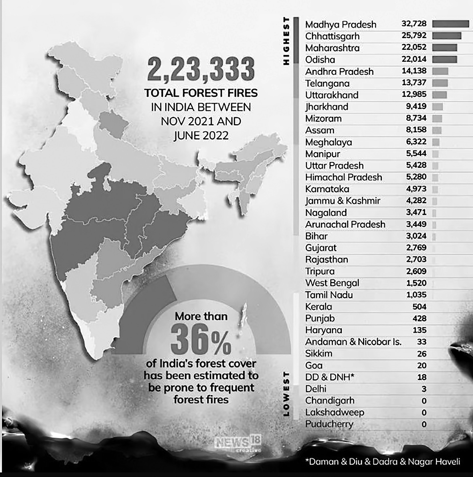
Figure: Forest Fires in 2021-22
Causes
• Forest fires are a common occurrence, especially during the summer months, and happen worldwide. They can be categorized into three main types:
• Naturally occurring or controlled fires that help maintain ecological balance.
• Fires triggered by human negligence, such as those caused by heat accumulation in dry leaves and vegetation during summer.
• Deliberate fires set by local communities, often intended to clear pine needles and encourage the growth of fresh grass, but these can quickly spiral out of control.
• Since such fires deplete the soil of micro nutrients and don’t help to enhance the green cover, villagers are being advised not to indulge in such reckless measures.
•
Many forest fires originate from natural phenomena such as lightning strikes, which can ignite trees. Historical records show instances of lightning-induced fires in India, southeastern and central United States, Australia, Finland, and parts of eastern and southern Africa.
• However, the majority of forest fires are caused by human negligence, such as carelessly discarding a lit bidi or cigarette butt, or an open fire left unattended by picnickers in dry forest conditions.
• These fires typically begin on the forest floor, as dry leaves and twigs ignite easily. If fueled by strong winds, the flames can rapidly spread, consuming large areas of forest and causing significant destruction unless brought under control in time.
Forest Fire Prone Areas Classification
• Forest Survey of India (FSI) has carried out a study based on spatial analysis of forest fires detected over the past 17 years (2004 to 2021), and have identified the fire prone forest areas in the country.
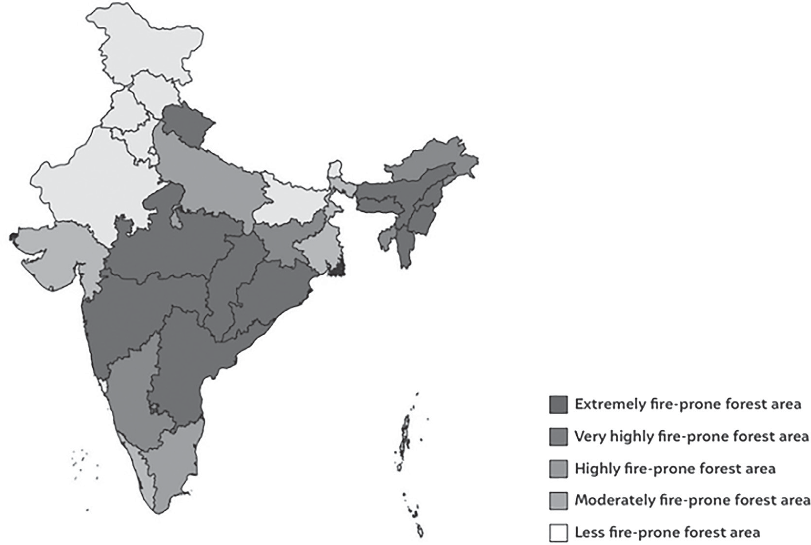
Map: Forest Fire Prone Areas in India
| Forest Survey of India (FSI) Classification of Forest Area into different Fire Prone Categories | |||
| S. No | Category | Forest Cover (in sq km) | % of total forest cove |
| 1 | Extremely Fire Prone | 20 074.47 | 2.81 |
| 2 | Very Highly Fire Prone | 56 049.35 | 7.85 |
| 3 | Highly Fire Prone | 82 900.1 7 | 11.61 |
| 4 | Moderately Fire Prone | 94,126.68 | 13.19 |
| 5 | Less Fire Prone | 4 60 638.36 | 64.54 |
| Total | 7,13, 789.03 | 100.00 |
Types of Forest Fire
Forest fires differ depending upon its nature, size, spreading speed, behaviour etc. basically this can be sub-grouped into four types depending upon their nature and size as follows:
• Underground Fire:
• Underground fires are low-intensity fires that consume organic material beneath the surface along with the litter on the forest floor. These fires are categorized as a subgroup of forest fires. In many dense forests, especially in the wetter regions of the Himalayas, a thick layer of organic matter accumulates above the mineral soil, making them susceptible to such fires.
• These fires spread entirely below the surface, burning a few meters underground at a slow pace, which makes them difficult to detect and control.
• Underground fires can persist for months, gradually consuming the soil’s vegetative cover. They are also
known as muck fires, and in some regions, they are referred to as ground fires.
• Surface Fires:
• Surface fires are the most common type of forest fires, burning undergrowth and dead vegetation along the forest floor. These fires are generally beneficial for forest regeneration and growth.
• However, if they intensify, they can consume ground flora, undergrowth, and even the middle layers of the forest, leading to significant damage.
• Surface fires spread through flaming combustion, igniting fuels at or near the surface, such as grass, fallen branches, dry leaves, forest needles, and debris from land clearing or harvesting activities.
• Ground Fires:
• Underground fires can smolder for a period before transforming into ground fires. These fires consume roots and other materials present on or beneath the
forest surface, including herbaceous growth and decaying organic matter.
• They cause more damage than surface fires, often leading to the complete destruction of vegetation. These fires occur in subsurface organic fuels such as duff layers under forest stands, Arctic tundra, taiga, and organic soils found in swamps or bogs.
• Ground fires spread beneath the surface through smoldering combustion and are usually ignited by surface fires. Due to their underground nature, controlling and extinguishing them is extremely challenging and requires significant effort.
• Crown Fires:
• Crown fires are highly unpredictable and spread rapidly, burning the upper canopy of trees with the help of strong winds.
• These fires are often ignited by surface fires, allowing the flames to move from treetop to treetop independently of the fire on the ground.
• In dense conifer forests, especially on steep slopes or flat terrain with strong winds, crown fires can spread swiftly, sometimes outpacing the surface fire below. This type of fire is one of the most dramatic and intense forest fires.
• Firestorms:
• Among the forest fires, the fires spreading most rapidly are the firestorm, which is an intense fire over a large area.
• As the fire burns, heat rises and air rushes in, causing the fire to grow. More air makes the fire spin violently like a storm.
Flames fly out from the base and burning embers spew out the top of the fiery twister, starting smaller fires around it. Temperatures inside these storms can reach around 2,000 degrees Fahrenheit
Linkages Between Forest Fires
Linkages between Forest Fires, Heat Waves, El Nino and Climate Change
2021 was one of the worst years for forest fires since the turn of the century, causing an alarming 9.3 million hectares of tree cover loss globally — over one-third of all tree cover loss that occurred that year.
Though down from the previous year, over 6.6 million hectares of tree cover was lost to forest fires in 2022, similar to other years over the past decade.
And in 2023, the world has already seen heightened fire activity, including record-breaking burns across Canada and catastrophic fires in Hawaii.
• The worst affected are the Boreal forests covering large coniferous forests in Russia, Canada, US, Finland, Norway, China and Japan followed by tropical forests covering biodiversity hotspots such as the Amazon, and the rainforests in southeast-Asia and India.
• Increasing tree cover loss due to fires in the tropics is
causing higher carbon emissions (just as it is in the Boreal forests).
• Previous studies found that in some years, forest fires accounted for more than half of all carbon emissions in the Brazilian Amazon. The Amazon basin may be nearing or already at a tipping point for turning into a net carbon source as opposed to one of world’s largest carbon sinks, the analysis said. The increase in forest fires is largely driven by climate crisis.
• Climate Change and Global Warming are major drivers of increasing fire activity. Greenhouse gas emissions from human activities have heated the planet by about 1.2 degrees Celsius since pre-industrial times.
• Climate change makes heatwaves hotter and more frequent. This is the case for most land regions, and has been confirmed by the United Nations’ global panel of climate scientists, the Intergovernmental Panel on Climate Change (IPCC).
• Hotter temperatures cause land to dry out and help create conditions for more frequent forest fires. This in turn leads to higher emissions further exacerbating climate change and contributing to more fires as part of a fire-climate feedback loop, the analysis added.
• Other climate drivers such as El Nino Southern Oscillation also play an important role in the increase in forest fires. During the 2015-2016 El Niño, for example, tree cover loss due to fires increased 10-fold in the tropical rainforests of Southeast Asia and Latin America. A new El Niño event emerged in June 2023 and is expected to last through early 2024.
• Scientists concur that without steep cuts to the greenhouse gases causing climate change, heatwaves, wildfires, flooding and drought will significantly worsen.
Forest Fire Risk Mitigation
Understanding Risk
• Monitoring, Research, Forecasting, Early Warning and Zoning/ Mapping
• Short Term Measures
• Conduct mapping of human settlements located within fire-prone forest regions.
• Continuously monitor areas susceptible to forest fires.
• Identify regions vulnerable to forest fires and keep a close watch during peak fire seasons.
• Medium Term Measures:
• Develop and sustain community-led networks for early fire detection and prompt reporting to local authorities.
• Encourage the implementation of a Community- Based Forest Monitoring System.
• Long Term Measures
• Establishing and maintaining arrangements to communicate effectively with people living within and near forests.
• Establish and maintain a System of Mutual Aid among nearby fire services and forest offices for sharing/ pooling of resources.
• Hazard Risk Vulnerability and Capacity Assessment
• Dissemination of warnings, data and information
• Systematic data management of data on disaster damage and loss assessments
Inter-Agency Coordination
• Preparation and implementation of DM plans and ensure the functioning of agencies with DM tasks.
• Organizing and coordinating the immediate response
• Coordinate with central agencies
• Coordinating the dissemination of warnings to all, down to the last mile- remote, rural or urban; Regular updates to people in areas at risk.
Investing in DRR – Structural Measures
• Strengthening various forest fire prevention measures.
• Specialized equipment to fight forest fires.
• Strengthening the network of Watch Towers.
• Expanding Fire Detection Systems.
• Ensure incorporation of Fire and Multi- Hazard Resistant features in the planning and execution of social housing schemes.
• Hazard resistant construction, strengthening, and retrofitting of all lifeline structures and critical infrastructure near forest areas and in forest villages.
• Setting controlled fires that mimic the low-intensity fires in natural ecosystem cycles,
• Introducing gaps within forests to stop blazes rapidly spreading over large areas.
Investing in DRR – Non-Structural Measures
• Strengthen the laws and regulations for forest fire prevention and control.
• Improve the institutional arrangements for forest fire prevention and control.
• Promote use of insurance/ risk transfer
• Prioritizing forest fire management in forestry plans.
Capacity Development
• Training and orientation programs for government staff and other stakeholders.
• Incorporating prevention and management of forest fires in the training programs of village volunteers.
• Promoting culture of awareness,alertness and preparedness.
• Carry out mass media campaigns in forest fire prone areas.
• Strengthening network of community involvement in
forest fire reporting, prevention and assistance.
• Involving forest communities/forest village committees, Joint Forest Management committees.
•
Joint execution of emergency drills with local bodies –
urban and rural in areas prone to forest fires.
Steps Taken to Mitigate Forest Fires
• The Ministry of Environment, Forest and Climate Change has prepared National Action Plan on Forest Fire 2018 to minimize forest fires.
• Forest Risk Zonation and Mapping: This is a scientific method for categorization of different areas on the basis of management interventions, allocating resources to priority areas and monitoring the effectiveness of measures to control fire risk.
• Community Awareness: Every state forest department should spend a satisfactory amount of money for sensitization of the state in general and the community in particular.
• Framework for Biomass Management for SFDs which says, “collection of dry woods, fallen pine needles should be encouraged to mitigate the surface fire.” Women Self-Help Groups (SHGs) should also be promoted for entrepreneurship generated by forest floor biomass.
• Digitization of Forest Boundaries, promoting greater adoption of the Forest Fire Alert System, Improving Ground-based Detection, Dedicated phone line and Monitoring and evaluation are some technological enhancement methods suggested in the framework for the action plan.
• Funding is provided under Forest Fire Prevention and Management Scheme, Development of Wildlife Habitats and Compensatory Afforestation Fund
Management and Planning Authority (CAMPA).
• The Moderate Resolution Imaging Spectroradiometer (MODIS) is used for active forest fire detection to get alerts about forest fires on cell phones through satellite imagery.
• In January 2019, the Ministry of Environment, Forest and Climate Change launched FAST (Fire Alert System). FAST will monitor forest fires in India using real time information from VIIRS.
• VIIRS (Visible Infrared Imaging Radiometer Suite): VIIRS is a weather monitoring equipment placed in satellites orbiting the earth. It is basically a sensor, that collects imagery and radiometric measurements of atmosphere, land, cryosphere and oceans. The data is collected in visible and infrared bands of electromagnetic spectrum.
• VIIRS is placed in Suomi National Polar Orbiting Partnership (Suomi NPP) and NOAA-20 weather satellites of USA.
• The VIIRS is mainly used to monitor and investigate changes and properties in surface vegetation.
• AVHRR is Advanced Very High-Resolution Radiometer.
• The combination of MODIS, VIIRS and AVHRR
help in assessing impacts of climate change on the earth surface.
Under the centrally sponsored scheme incentives are provided to the communities, Joint Forest Management Committees, Eco Development Committees for protecting the forests from fires.
Funding is provided under the Centrally Sponsored Forest Fire Prevention and Management Scheme, Development of Wildlife Habitats, and under Compensatory Afforestation Fund Management and Planning Authority.
• The funds are used for creation and maintenance of fire lines, construction of water conservation structures, procurement of firefighting equipment,
awareness creation, and incentivizing villages/ communities for protection against forest fire etc.
• Modern Forest Fire Control Project: The overall development objective of the project is to ensure an adequate quantity and quality of forest products from both natural and human-made forest, as well as the protection of soils and environment on lands where the protective and productive role of forests and forest vegetation is accorded national land-use priority. The specific objectives are:
• To devise, test and demonstrate principles and techniques of prevention, detection and suppression of forest fires in the states of Uttar Pradesh and Maharashtra;
• To determine the technical, socioeconomic and financial feasibility of the application of modern forest fire-fighting techniques in India to enable the
government to take appropriate investment decisions in this respect;
• To institute an effective, useful and appropriate system of fire statistic reporting, recording and dissemination;
• To establish through appropriate fire behaviour trials a Fire Danger Rating System applicable to the major fuel types encountered, suitable for use as a basis for extrapolation nationally;
• To formulate an effective programme to strengthen the fire prevention, detection and suppression capabilities of the forest and rural fire protection authorities in the two States;
• To organize and promote a Cooperative Fire Prevention Programme based on the active participation of rural communities;
To establish a Cooperative Programme of Fire Management with other departments and authorities, including agreements for reciprocal and mutual aid benefits, and to facilitate the integration of forest fire protection into overall development plans.
Thunderstorm and Lightning
Thunderstorm and Lightning
• A thunderstorm is a brief yet intense weather phenomenon typically accompanied by lightning, thunder, dense cloud cover, heavy rainfall or hail, and strong gusty winds. It occurs when layers of warm, moisture-laden air rapidly ascend to higher, cooler levels of the atmosphere in a powerful updraft. As the air rises, the moisture condenses, leading to the formation of towering cumulonimbus clouds, which ultimately result in precipitation.
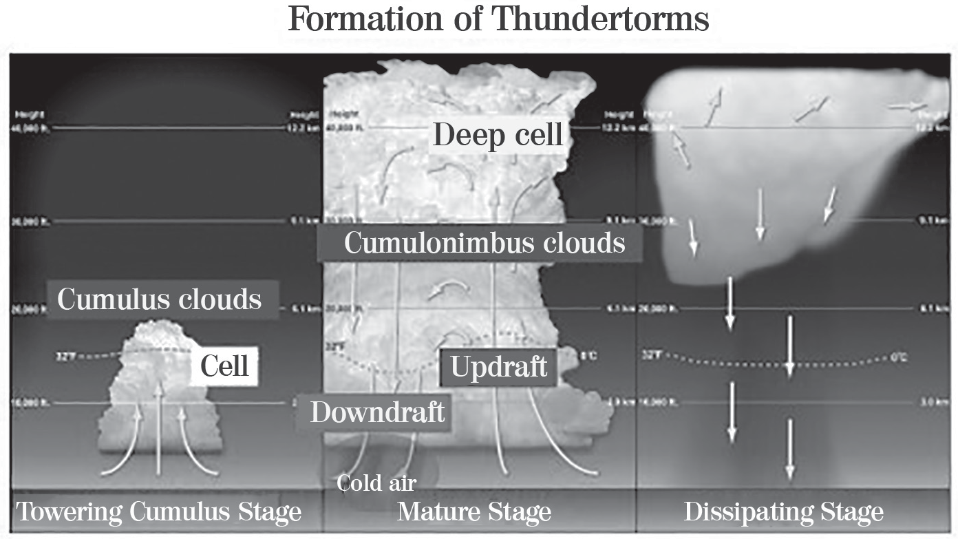
• A thunderstorm is said to have occurred if thunder is heard or lightning is seen. Usually, the thunder can be heard up to a distance of 40 km from the source of origin.
• Thunderstorms fall in the category of Meso-gamma weather systems with a spatial extent of around 2~20 km and a temporal scale of a few hours. Considering their intensity, the thunderstorms in India are categorized as follows:
• Moderate thunderstorm: Loud peals of thunder with associated lightning flashes, moderate to heavy rain spells and maximum wind speed of 29 to 74 kmph.
• Severe thunderstorm: Continuous thunder and occasional hailstorm, and maximum wind speed exceeding 74 kmph.
•
Thunderstorms occur round the year in different parts of the country. However, their frequency and intensity are maximum during summer months (March to June) as the most important factor for the occurrence of thunderstorms is the intense heating up of the atmosphere at the surface level.
• IMD data (1950-1980) shows that more than 80 thunderstorm and lightning days occur over the northeast, and some parts of Kerala and Jammu &Kashmir each year. In India, more than 2,500 people die due to thunderstorm and lightning every year. Experts believe that due to rising global temperature and climate change (IPCC Special Report, 2018 - Global Warming of 1.5 C), the severity and frequency of thunderstorms/dust storms will rise in the years ahead.
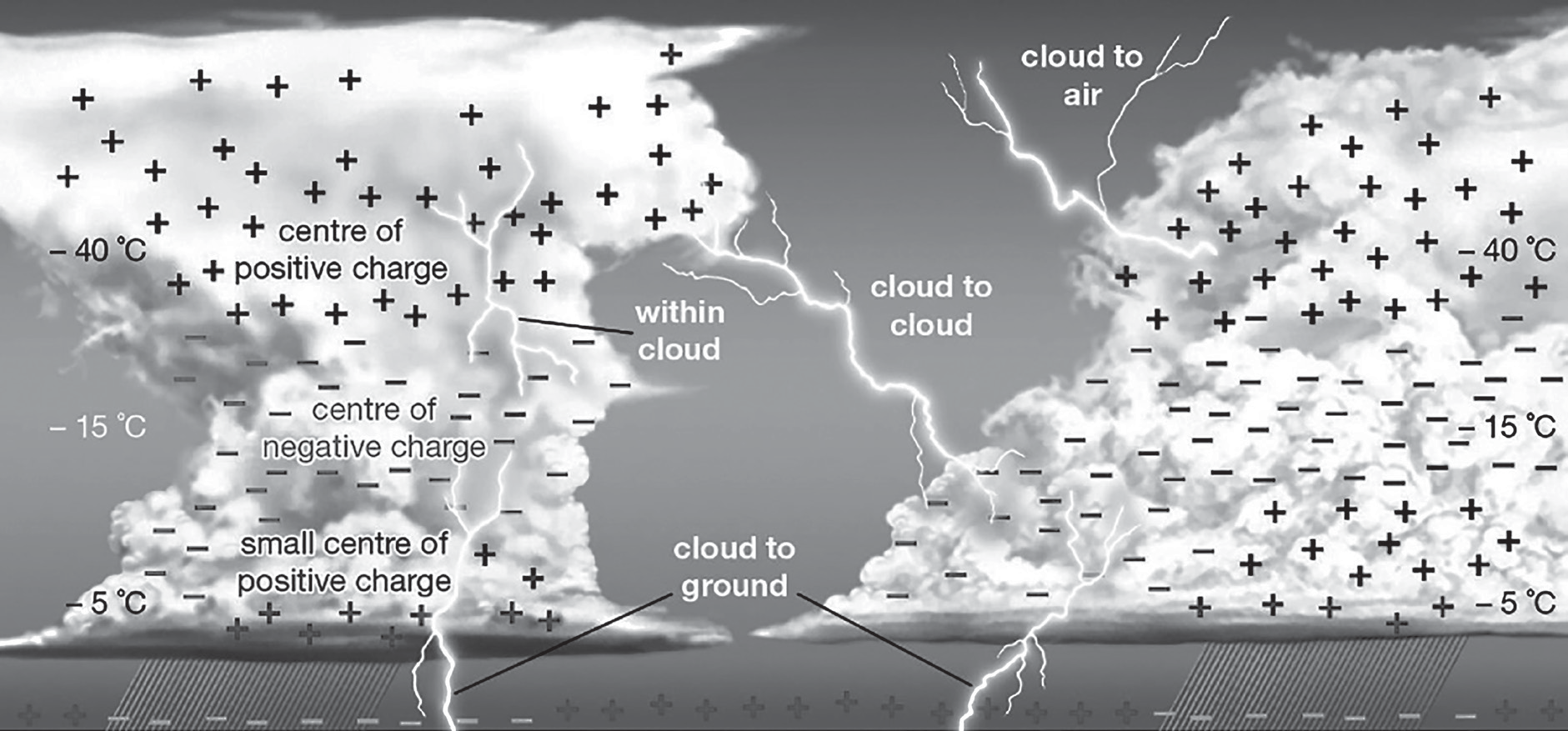
Figure: Lightening
• Lightning is a high-energy luminous electrical discharge
accompanied by thunder. It is of three types:
• Thundercloud or Intra-cloud lightning (IC)
• Cloud-to-cloud or Inter-cloud lightning (CC)
• Cloud-to-ground lightning (CG)
• Lightning has a total path length of a few kilometres. Its peak power and total energy are very high, with the peak power discharge in the order of a 100 million watts per meter of the channel and the peak channel temperature approaching 30,000 C.
• Peak currents in a lightning discharge range up to hundreds of kilo amperes (kA) with its typical value being 40 kA. Predicting the precise time and location of lightning is very difficult. However, a season or a period of lightning occurrence is known for many regions.
• The charged regions in the atmosphere temporarily equalize themselves through this discharge referred to as a Flash. A lightning flash becomes a strike if it involves an object on the ground.
• The flow of electric charges can affect any electrically conductive body. Hence, electrical appliances, if operated during a lightning strike, can affect their normal functioning and have a risk of becoming faulty. Similarly, living beings coming in contact with lightning, either directly or indirectly through electrical conductors, can be affected, which may lead to severe burns or even death. Lightning strikes the Earth 50 to 100 times each second.
• Example: Gujarat’s Kutch is India’s most lightning- prone district, along with Odisha’s Mayurbhanj, but the mortality is much higher in the latter, as per the Annual Lightning Report 2021-22.
• Squall/Dust/Hailstorm and Strong Winds
• Thunderstorms have some typical characteristics such as the formation of a squall, strong updraft and downdraft, towering cumulonimbus clouds associated with turbulence and icing, in-cloud electrification and associated lightning, localized strong rain and hailstorm.
• A dust storm, associated with a thunderstorm and strong winds, generally occurs in arid and semi-arid regions. It lifts loose dust from dry land area.
Impact of Thunderstorm/Lightning
• In India, thunderstorms and lightning cause over 2,500 fatalities annually on average.
• Rural and forested regions are at higher risk due to the presence of tall trees and water bodies. Most lightning- related casualties involve individuals working in agricultural fields in rural areas.
• Lightning is a significant factor in electrical power failures and forest fires. It can also harm communication systems, computer equipment, and disrupt aircraft navigation.
• Moderate thunderstorms can damage thatched huts, unpaved roads, standing crops, orchards, and power and communication infrastructure.
• Severe thunderstorms can lead to extensive destruction of thatched houses and huts, dislodging rooftops and causing loosely secured metal sheets to become airborne. They can also damage roads, power lines, and communication systems while triggering floods, breaking tree branches, and uprooting large trees.
Prevention, Mitigation and Preparedness Measures
Preventive Measures: Disaster prevention includes actions designed to reduce the likelihood of a disaster occurring and to prevent its impact on communities. While thunderstorms cannot be stopped, their adverse effects can be mitigated through various measures:
• Hazard and Vulnerability Assessment: Conducting micro-level hazard mapping to identify and mark vulnerable areas. The assessment report should categorize vulnerability levels (mild, moderate, or severe) and estimate potential crop damage costs based on different storm intensities.
• Training for Disaster Managers, Planners, and Decision-Makers: Raising awareness among planners and policymakers can significantly reduce the impact of thunderstorms on communities.
• Public Awareness and Education: Spreading awareness and educating the public helps enhance community resilience against disasters.
Mitigation and Preparedness Measures
Enhanced understanding of preparedness and mitigation measures
• Hazard Resistant Construction
• Laying underground electricity cables and telephone lines
• Emergency Communication Systems
• Integrating Development schemes with Disaster Management Schemes
•
Technical, Social, Organizational and Administrative
preparedness
• Focusing on Research and Establishing a Forecasting Centre for Thunderstorm
• Making Disaster Risk Reduction (DRR) a part of school and college curriculum
• Installation of lightning arrestors and sound earthing for each building is essential. Lightning shields are the most commonly employed structural protection measure for buildings and other structures.
Steps Taken to Mitigate thunderstorm and Lightening
• For providing alert regarding lightning Govt. of India has launched “Damini Lightning App”. The app alert the person if lightning is happening near the person by GPS notification under 20KM to 40KM radius. It also provides the lightning warning at the location valid for next 40 minutes.
• India is among a few countries which has introduced a Lightning Warning System. Besides, ISRO is providing satellite information from INSAT-3DR about convective clouds, which is uploaded every 15 mins. We are also capable of having real time information about lightning updated in every 5 mins.
• NDMA Guidelines for preparation of Action Plan
– Prevention and Management of Thunderstorm & Lightning/ Squall Dust/Hailstorm and Strong Winds.
• Community-centric outreach programme called ‘Lightning Resilient India Campaign’ has been initiated by initiative of Climate Resilient Observing-Systems Promotion Council (CROPC) with support from NDMA, IMD, Union Ministry of Earth Sciences, Indian Meteorological Society among other stakeholders.
Desert Locust Attack
Desert Locust Attack
Desert Locusts (Schistocerca gregaria) are considered the most destructive among locust species. When environmental conditions are favorable, even a small number of solitary locusts can rapidly increase in population, forming massive swarms that migrate across vast regions. These swarms pose a significant threat to agriculture across large areas of Africa, the Middle East, and Southwest Asia.
In the past century, there have been six major Desert Locust plagues, with one lasting nearly 13 years.
During 2019-20, locust attack was reported in some districts of Rajasthan and Gujarat. Rajasthan Government has reported that a total area of 1,79,584 hectares of 8 districts of the state was affected by locust attack during 2019-20.
According to the Food and Agricultural Organisation (FAO) of the United Nations, a swarm of locusts spread across an area of one square kilometre can eat as much food as 35,000 people in one day. Their appetite is voracious and one locust can consume food equal to its own weight – about two grams – on
a daily basis. And since a square kilometre swarm would contain about 40 million locusts, it can cause a significant amount of damage in a short period of time.
Figure: Locust Pest Attack
• Initial Desert Locust control efforts were largely curative but the trend in the twentieth century had been toward preventing such plagues from occurring. Affected countries have assumed ever more responsibility for monitoring locust breeding areas and treating infestations before they increase in size and number.
• Favourable conditions for desert locusts to breed consists of moist sand and green vegetation in arid areas. These favourable conditions were made available to the locusts in the desert region of Africa and Arabian Peninsula due to heavy rainfall that the region witnessed in 2019. They then migrated to India via Iran and Pakistan.
Heavy rainfall was caused by unusually warm waters in the western Indian Ocean in late 2019. And the unusually warm waters were caused by climate change or global warming.
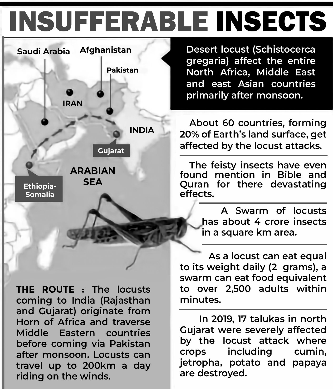
These warm waters were caused by the phenomenon called the Indian Ocean Dipole — with warmer than usual waters to its west, and cooler waters to its east. Rising temperatures due to global warming amplified the dipole and made the western Indian Ocean particularly warm.
Strategy to Control Pest Attack
• International collaboration plays a crucial role in effectively managing locust infestations. A notable example is the coordinated effort between India and Pakistan during the 2020 locust attack. This approach has proven highly successful, as nations increasingly recognize that joint efforts are essential in combating Desert Locusts.
• Strategic interventions can be implemented at specific times or targeted areas. For instance, delaying control measures until locusts gather in a concentrated space enables a more efficient response, allowing a greater number of locusts to be controlled using a reduced amount of pesticides over a smaller area.
• The key challenge in the coming years will be to refine Desert Locust management strategies in a way that safeguards food security while also reducing negative environmental impacts.
Steps Taken to mitigate Locust Attack
• Central Government has established the Locust Warning Organisation (LWO) which tracks and monitors the Locust swarms and their breeding and migration patterns, to issue early warning.
• Spraying of pesticides like Malathion through vehicle- mounted sprayers,
• States notifying locust invasion as “mid-season adversity” under the Pradhan Mantri Fasal Bima Yojana (PMFBY) and announcing disaster relief packages.
Man Made Disaster
Man-Made Hazards: Chemical Disasters
• Chemical disasters involve the release, fire, or explosion of hazardous chemicals during industrial operations, storage, or transportation, or as a result of natural events. These incidents can have severe consequences both within and beyond the affected site, leading to loss of life, property damage, and environmental harm.
• Given the critical role of chemicals in modern industries, managing chemical disasters has become a significant concern for governments, the private sector, and communities. Such disasters can have devastating effects on people, nature, and infrastructure. The most vulnerable elements in a chemical disaster include industrial facilities, workers, vehicles transporting
hazardous chemicals, nearby residents, adjacent structures, and the surrounding community. Chemical disasters can occur through various means :
• Process and safety systems failures
• Human errors
• Technical errors
• Management errors
• Induced effect of natural calamities
•
Accidents during the transportation
• Hazardous waste processing/ disposal
• Terrorist attack/ unrest leading to sabotage
Status of Chemical Disaster Risk in India
• India experienced the world's worst industrial disaster, the Bhopal Gas Tragedy in 1984. This catastrophic incident involved the accidental release of the highly toxic gas Methyl Iso Cyanate (MIC), leading to thousands of deaths and making it one of the most devastating chemical accidents in history.
• Chemical accidents have far-reaching consequences, causing injuries, loss of life, and extensive damage to property and the environment. Despite the lessons from Bhopal, India has continued to face chemical disasters.
• Over the past decade alone, the country has recorded 130 major chemical accidents, resulting in 259 fatalities and 563 serious injuries.
• Currently, India has approximately 1,861 Major Accident Hazard (MAH) units spread across 301 districts in 25 states and 3 Union Territories. In addition, numerous registered hazardous factories and unorganized sectors handle dangerous materials, presenting significant and complex disaster risks across the country.
Causative factors
• The aging infrastructure of process plants and the slow adoption of modern technologies in India's chemical industry have heightened the risk of chemical disasters.
• Fire, explosions, toxic releases, or a combination of these hazards can occur during transportation, storage, or processing due to various factors such as temperature and pressure deviations, runaway reactions, mixing
of incompatible substances, catastrophic failures of reactors or storage vessels, leaks, hardware malfunctions, inadequate agitation, improper reactor vent designs, and insufficient process hazard analysis.
• Organic solvents remain the leading cause of fires and explosions in the chemical sector.
• A significant number of industrial accidents are attributed to human error, often resulting from non-compliance with Standard Operating Procedures (SOPs) established by the company.
• Chemical disasters have also stemmed from design flaws, lack of SOPs for early warning systems, and poor coordination among departments within chemical
facilities.
• Additionally, risks have escalated due to threats such as
terrorism and sabotage.
• Natural disasters like earthquakes and floods have also played a major role in triggering chemical accidents.
• Another prevalent cause of such disasters is poor maintenance of equipment, which compromises safety and operational efficiency.
• Non-availability of an emergency response team to mitigate accidents during the transportation of hazardous chemicals have also resulted in major disasters in several locations in India.
Impact
The consequences of such emergencies can be severe, encompassing loss of life injuries, psychological and physiological health impacts, and extensive damage to environmental resources such as land, soil, water bodies, air quality, and ecosystems. These incidents can also disrupt local climate patterns, agriculture, forests and biodiversity, leading to the degradation of environmental services like water supply, sanitation, waste management, and public health. Additionally, structural damage to buildings, machinery and facilities may occur, resulting in financial burdens, including insurance claims, economic setbacks, loss of productivity, wages and incentives. Such disasters can also heighten vulnerability to other hazards, whether natural or environmental, and contribute to social unrest, legal disputes, governance challenges, and instability in law and order.
Prevention and Response
As far as chemical accidents are concerned, prevention is the best proactive approach rather than the reactive methods to chemical disasters. Each of the following stakeholders has a role and responsibility.
Role of Industry
• Identification of Hazardous Activities:
• A thorough understanding of safety measures in industrial operations is crucial for preventing and controlling accidents.
• A competent and dedicated team of qualified professionals should assess potential hazards and risks associated with daily activities.
• Employing hazard identification techniques such as checklists, safety audits, and risk analysis can aid in mitigating dangers.
• Maintenance of Plant Facilities and Equipment:
• Regular maintenance of machinery and equipment should be conducted to ensure their proper functioning.
• Routine safety and health inspections should be performed to confirm that the facility remains safe and all equipment operates as intended.
• Installation of Gas/Vapour Detection Systems:
• Implementing a gas or vapour detection system with alarms can help detect leaks at micro levels, ensuring that issues are addressed promptly.
• Compliance with Regulations:
• Strict adherence to state and central regulations is necessary for maintaining a safe and sustainable industrial process.
•
Human Resource Management Development:
• Managing human resources effectively is complex and requires continuous monitoring, along with the implementation of behavior-based safety programs.
• Industries should establish a structured human resource management system led by senior officials to enhance workplace safety.
• Creating an open and communicative environment between management and employees will enable workers to report unsafe practices or hazards.
• Emergency Preparedness:
• Industries should maintain a well-trained emergency response team capable of acting swiftly to contain escalating disasters.
• Regular mock drills should be conducted to ensure workers are adequately prepared to handle emergencies.
Role of Government
• The comprehensive legal/ institutional framework exists in our country. A number of regulations covering the safety in transportation, liability, insurance and compensations have been enacted.
• Following are the relevant provisions on chemical disaster management, prevailing in country:-
| Explosives Act 1884 | Petroleum Act 1934 |
| Factories Act 1948 | Insecticides Act 1968 |
| EnvironmentProtection Act 1986 | Motor Vehicles Act 1988 |
| Public Liability Insurance Act 1991 | Disaster Management Act 2005 |
• The Government of India has further strengthened the legal framework for chemical safety and the management of chemical accidents by introducing new regulations, including MSIHC Rules, EPPR Rules, SMPV Rules, CMV Rules, Gas Cylinder Rules, Hazardous Waste Rules, and Dock Workers Rules, along with amendments to existing laws.
• Additionally, the National Action Plan on Chemical Industrial Disaster Management (NAP-CIDM) has been developed, serving as a strategic roadmap for managing chemical disasters in India.
• Establishment of an Accident Investigation Board and Chemical Accident Database:
• Dedicated accident investigation board, modeled after the Chemical Safety Board of the USA, could be established in India to analyze chemical disasters and formulate preventive guidelines based on lessons learned from each incident.
• There is also a need for a specialized accident reporting system and an exclusive database to document chemical accident cases for better monitoring and prevention.
• An online platform could assist industries in addressing various safety concerns by facilitating expert guidance from around the world. This would help prevent unforeseen issues arising from plant operations.
• Awareness Campaigns:
• Raising public awareness about potential hazards and their consequences is crucial, as it enables communities to actively participate in disaster mitigation and recovery efforts.
• Research and Development:
• The government can promote research and development initiatives focused on innovative technologies that reduce the toxicity of byproducts from chemical industries.
• Offsite Emergency Planning:
• The goal of offsite emergency planning is to ensure that local authorities effectively fulfill their responsibilities in minimizing the impact of major accidents on people and the environment near industrial sites.
• This planning must align with existing regulations and guidelines.
• Transportation of Hazardous Chemicals:
• The Indian Chemical Council (ICC) has recently launched the "Nicerglobe" program (nicerglobe.in), which enables GPRS tracking of chemical transport vehicles from their point of origin to their final destination. This platform is well-integrated with emergency response services. Chemical industries are encouraged to participate in this initiative to enhance the safe transportation of hazardous materials.
Role of Public
• Having a general understanding of the risks associated with chemical accidents can significantly help in minimizing their impact.
• Forming mutual aid groups can help organize the general public during emergencies by providing training and awareness about appropriate actions to take in the event of a chemical leak.
Conclusion
• Although disasters in the chemical industry are rare, negligence or unforeseen circumstances can lead to catastrophic outcomes. Beyond the immediate impacts—such as loss of life, environmental hazards, and destruction of infrastructure—the damage to the industry's reputation is often irreversible. The repercussions of a chemical disaster can persist across generations, causing long-term harm that is immeasurable for the affected communities.
Dam Failures
• A dam failure or dam burst is a catastrophic type of structural failure characterized by the sudden, rapid, and uncontrolled release of impounded water or the likelihood of such an uncontrolled release. Between the years 2000 and 2009 more than 200 notable dam failures happened worldwide.
• According to recent UN research, 3,700 dams in India will lose 26% of their total storage capacity by 2050 as a result of sediment buildup, which could eventually jeopardize future water security, irrigation, and power generation.

Figure: Definition of Large Dam
• India has 5334 large dams; third largest after USA and China. Other 411 large dams are under various stages of construction. About 1,100 of the more than 5,200 major dams that have been erected so far have reached the age
of 50, and others are more than 120 years old. By 2050, there will be 4,400 of these types of dams, or 80% of the country’s major dams, which will range in age from 50 to more than 150 years.

Figure: Causes of Dam Failures
• Machchu II Dam Failure (1979): Due to heavy rainfall and improper design, the Machchu II Dam in Gujarat, India, burst, resulting in a catastrophic flood. The torrential flow destroyed villages, claiming the lives of over 2,000 people.
• In 2022, the massive floods in Godavari have exposed the flood vulnerability of giant projects like Polavaram and Kaleshwaram. Also there have been multiple dam failures and dam induced floods in particularly in Rajasthan, Madhya Pradesh, Maharashtra, Tamil Nadu and Kerala. There are more than 40 reported failures cases so far, 64% in newly built dams of age upto 10 years.

Map: Dams as Cause of Floods
• The Hazard Classification of a dam is based on the downstream damage that would result if the dam were to fail. The hazard classification has no relationship to the condition of the dam, its structural integrity, operational status, or flood storage capability.
Classification of Dams
• The International Commission on Large Dams (ICOLD), considers any dam is Large Dam if its height is 15 meters or more measured from the lowest point of foundation to top of the dam. Dams with a height of 10 m or more
are considered as High Dams, if they satisfy one of the following criteria or a combination of more than one.
| Criterion | Requirement |
| Length of crest | > 500 m |
| Volume of reservoi | > 1 million m3 |
| Design flood | > 2000 m3/sec. |
| Geological conditions | Difficult |
| Other considerations | Unusual Design |
Potential Hazard Classifications (PHC) [International Commission on Large Dams (ICOLD)]
| Component | Potential Hazard Classification (PHC) | ||
| Low- (I) | Medium- (II) | High- (III) | |
| H2 𝑉 | H2 𝑉<20 | 20
| |
| Life Safety Risk (Number of lives) | ~ 0 | < 10 | 10 |
| Economic Risk | Low | Moderate | High or extreme |
| Environmental Risk | Low or Moderate | High | Extreme |
| Social Disruption | Low (rural area) | Regional | National |
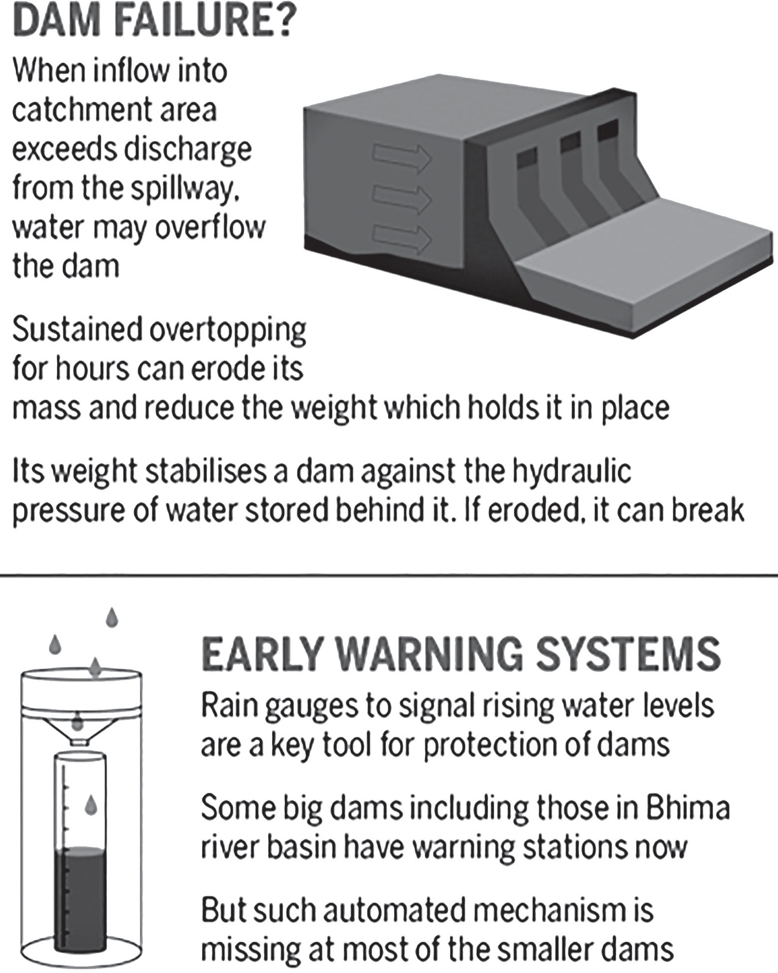
Figure: Dam Failure and Early Warning
Dam Safety Legal and Institutional Framework in India
• The safety of the dams in India is the principal concern of the State agencies and other organisations that own the dams and are involved in various aspects of their investigations, planning, design, construction operation and maintenance.
• Dam Safety Organization (DSO) was established in Central Water Commission (CWC), in May 1979 So far, 14 States – namely, Andhra Pradesh, Bihar, Chattisgarh, Gujarat, Jharkhand, Kerala, Tamil Nadu, Maharashtra, Madhya Pradesh, Orissa, Karnataka, Rajasthan, Uttar Pradesh, and West Bengal – having significant number of dams, have created State level DSOs.
• Dam Safety Act 2021: An Act to provide for surveillance, inspection, operation and maintenance of the specified dam for prevention of dam failure related disasters and to provide for institutional mechanism to ensure their safe functioning. The Act comprehensively addresses the critical dam safety concerns under prevailing as well as new issues such as climate change, etc. Its key provisions include:
• Regular inspection of dams;
• Hazard Classification of Dams;
• Emergency Action Plan;
• ComprehensiveDam Safety Review byan independent panel;
• Funds for timely repair and maintenance;
• Operations and maintenance manual;
• Record of incidents and failure;
• Risk Assessment Study;
• Dam instrumentation including Hydro-Meteorological and Seismological Network;
• Accreditation of agencies;
• Emergency Flood Warning System; and
• Offences and penalty.
• National Committee on Dam Safety: It has been set up under the Chairmanship of the Chairman, Central Water Commission (CWC) to help evolve uniform dam safety policies, protocols and procedures.
• Review of national scenario concerning safety of dams
• Preparation of Emergency Action Plan (EAP) and Reservoir Operation
• Instrumentation of Dams
• Dam Safety Review Panel (DSRP)
• National Register of Large Dams – Updating as per
new formats
• Dam rehabilitation and improvement schemes
• Records of Dam Failures and Major Dam Incidents and their Technical Reports
• Implementation of National Hydrology Project
• Setting up Hydrology units and Design Floods Review and Monitoring of safety aspects of inter- state dams by Sub-Committees etc.
• National Dam Safety Authority as a regulatory body to implement the policy, guidelines and standards for proper surveillance, inspection and maintenance of specified dams and resolve disputes of issues between the State Dam Safety Organisation of two States, or between the State DSO of a State and the owner of a dam in that State, and in certain cases, such as dams extending in two or more States or dams of one State falling under the territories of another State
Biological Disasters
• Biological disasters refer to the severe consequences resulting from the widespread proliferation of specific living organisms that can trigger diseases, viral infections, or large-scale infestations affecting plants, animals, or insects. These events can escalate to epidemic or pandemic levels, posing significant threats to public health and ecosystems.
• Notable examples of biological disasters include outbreaks of cholera, H1N1 influenza (swine flu), and COVID-19.

Figure: Classification of Biological Disasters
• Epidemic-level biological disasters impact a significant number of people within a specific community or area, while pandemic-level biological disasters affect a much larger region, often extending across entire continents or globally.
• For example, cholera is considered an epidemic, while COVID-19 is classified as a pandemic.
• Biological hazards, or biohazards, are biological substances or organic materials produced by parasites, viruses, bacteria, fungi, and proteins that pose a risk to the health of living organisms, especially humans.
• The harmful effects of these biohazards on human health typically fall into three categories: infections, allergies, and poisoning.
• The Ministry of Health and Family Welfare serves as the primary body responsible for managing epidemics, making decisions, providing advisory services, and offering emergency medical relief.
• According to the Indian Constitution, health is a state responsibility, meaning that the state governments hold the primary duty for addressing biological disasters.
• The National Institute of Communicable Diseases (NICD) is the central agency tasked with investigating outbreaks, while the NICD and the Indian Council of Medical Research (ICMR) offer support in terms of research, training, teaching, and laboratory services.
Biological Warfare
Biological Warfare (BW), also referred to as Germ Warfare, involves the use of biological toxins or infectious agents like bacteria, viruses, and fungi with the purpose of killing or incapacitating humans, animals, or plants as a form of warfare.
• Biological weapons, often called "bio-weapons," "biological threat agents," or "bio-agents," are living organisms or replicating entities (such as viruses, which are not universally regarded as "alive") that reproduce or replicate inside their host victims.
• Entomological (insect) warfare is also categorized as a type of biological weapon.
• NBC is the military acronym for nuclear, biological, and chemical warfare, referring to the use of weapons of mass destruction.
• There is a connection between biological warfare and chemical warfare, as the use of toxins produced by living organisms may also be classified as bioterrorism.
• The Ministry of Home Affairs (MHA) is the primary ministry responsible for BW and collaborates with the Ministry of Health and Family Welfare in managing it. MHA handles threat assessment, establishes deterrent mechanisms, and provides intelligence inputs.
Legislation
There are a number of legislations that control and govern the nation’s health policies. The government can enforce these legislations to contain the spread of diseases.
•
The Water (Prevention and Control of Pollution) Act, 1974
• The Air (Prevention and Control of Pollution) Act, 1981
• The Environmental (Protection) Act, 1986, and the Rules (1986). This Act also provides for the Biomedical Waste (Management) Rules with a view to controlling the indiscriminate disposal of hospital/ biomedical wastes.
• The Disaster Management Act (DM Act), 2005, provides for the effective management of disasters and for all matters connected therewith or incidental.
• The Epidemic Diseases Act 1897
The Epidemic Diseases Act 1897
• This Act does not grant the central government the authority to intervene in biological emergencies.
• It needs to be replaced by an Act that addresses the current and anticipated public health needs, including emergencies like biological terrorism (BT) attacks, the use of biological weapons by adversaries, cross-border issues, and the global spread of diseases.
• The new Act should empower both central and state governments, as well as local authorities, to take necessary actions, such as notifying affected areas, restricting movement, or quarantining impacted zones. It should also grant authority to enter premises to collect samples of suspected materials and seal them.
• Additionally, the Act should establish regulations for the transfer of biological samples, as well as enforce biosecurity and biosafety protocols for materials and laboratories.
Infrastructure
• At the operational level, Command and Control (C&C) are clearly defined at the district level, where the district collector holds specific powers, such as requisitioning resources, declaring a disease, inspecting premises, requesting assistance from the Army or state/central authorities, and enforcing quarantine. However, there is no established concept of an incident command system, where the entire response is managed by an incident commander with support from logistics, finance, and technical teams. There is an urgent need to implement an incident command system in every district.
• There is a significant shortage of medical and paramedical staff at the district and sub-district levels. Additionally, there is a severe lack of public health specialists, epidemiologists, clinical microbiologists,
and virologists.
• Biosafety laboratories are required for the prompt diagnosis of the agents for the effective management of biological disasters. There is no BSL-4 laboratory in the human health sector. BSL- 3 laboratories are also limited. Major issues remain regarding biosecurity, the indigenous capability of preparing diagnostic reagents, and quality assurance.
• The US Centre for Disease Control classifies biohazards into four biosafety levels as follows:
• BSL-1: Bacteria and Viruses including Bacillus subtilis, some cell cultures, canine hepatitis, and non-infectious bacteria. Protection is only facial protection and gloves.
• BSL-2: Bacteria and viruses that cause only mild disease to humans, or are difficult to contract via aerosol in a lab setting such as hepatitis A, B, C, mumps, measles, HIV, etc. Protection – use of autoclaves for sterilizing and biological safety
cabinets.
• BSL-3: Bacteria and viruses causing severe to fatal disease in humans. Example: West Nile virus, anthrax, MERS coronavirus. Protection – Stringent safety protocols such as the use of respirators to prevent airborne infection.
• BSL-4: Potentially fatal (to human beings) viruses like Ebola virus, Marburg virus, Lassa fever virus, etc. Protection – use of a positive pressure personnel suit, with a segregated air supply.
• Absence of an Integrated Ambulance Network (IAN): There is no ambulance service equipped with advanced life-support facilities capable of handling biological disasters.
• State-operated hospitals have limited medical resources. Even under normal circumstances, patients are required to purchase their own medicines. There is a lack of essential supplies such as drugs, key vaccines like
the anthrax vaccine, personal protective equipment (PPE), and diagnostics to manage increased demand. During a crisis, the situation worsens due to complicated procurement processes.
National Disaster Response Force (NDRF): The leadership and oversight of the NDRF fall under the Director-General of Civil Defence and the NDRF, appointed by the Central Government. Currently, the NDRF consists of eight battalions, which are deployed at various locations based on the requirements.
Prevention of Biological Disasters
• Prevention and preparedness efforts should concentrate on evaluating biothreats, understanding the medical and public health impacts, developing medical
countermeasures, and implementing long-term strategies that reduce vulnerability and help mitigate post-disaster consequences.
• Key elements of prevention and preparedness include pre-exposure immunization (as a preventive measure), establishing an epidemiological intelligence gathering system, creating a strong surveillance network
capable of detecting early warning signals, interpreting
epidemiological data to assess whether an attack is intentional, and enhancing capacity for surveillance, laboratory operations, and hospital systems that support outbreak detection, investigation, and management.
•
Vulnerability Analysis and Risk Assessment
• Environmental Management
• Ensuring a safe water supply and proper maintenance of sewage systems is essential in preventing biological disasters and waterborne epidemics like cholera, hepatitis, diarrhea, and dysentery.
• Promoting personal hygiene by raising awareness in the community about its importance, along with providing washing, cleaning, and bathing facilities, and preventing overcrowding in sleeping areas.
• Vector Control – Key components of vector control
programs include:
• Environmental engineering efforts and general integrated measures for vector control.
• Removal of breeding sites through water management, draining stagnant pools, and preventing water accumulation.
• Outdoorfogging and regular insecticide spraying to control vectors.
• Monitoring and managing rodent populations.
• Proper burial or disposal of dead bodies.
Prevention of Post-disaster Epidemics
The risk of epidemics increases after any disaster, whether natural or manmade. Preventive measures will be implemented to address such situations.
• Integrated Disease Surveillance Systems: A surveillance team will track potential sources, modes of transmission, and investigate outbreaks.
• Detection and Containment of an outbreak involves four key steps:
• Recognition and diagnosis by primary healthcare providers
• Reporting of surveillance data to public health authorities
• Epidemiological analysis of the gathered data
• Provision of appropriate medical treatment and public health interventions
• Pharmaceutical Interventions: This includes chemoprophylaxis, vaccination, and other preventive methods.
• Biosafety and Biosecurity: A system for inventory management should be in place in laboratories handling bacteria, viruses, or toxins that could be potential agents for biological disasters.
• Protection of important buildings and offices from biological agents, where necessary, can be achieved by limiting access to authorized personnel only through proper screening. Installing High Efficiency Particulate Air (HEPA) filters in the ventilation systems of air conditioning units will prevent infectious microbes from circulating within critical buildings. The post-exposure
approach will involve effective decontamination and safety protocols.
• Training of personnel and public health education.
Nuclear and Radiological Disaster
• A nuclear disaster occurs due to the extraordinary release of radioactive material or radiation, either during the operation of nuclear reactors or other nuclear events, such as the explosion of a Radiological Dispersal Device (RDD), Improvised Nuclear Device (IND), or a nuclear weapon.
• A Nuclear and/or Radiological Emergency (NRE) refers to an incident that results, or has the potential to result, in exposure to or contamination of workers or the public beyond permissible limits. These emergencies are categorized into five main types:
• An accident occurring at any nuclear facility within the nuclear fuel cycle, including nuclear reactors, or at a facility using radioactive sources, leading to a large- scale release of radioactivity into the environment.
• A ‘criticality’ accident at a nuclear fuel cycle facility, where an uncontrolled nuclear chain reaction occurs, causing bursts of neutrons and gamma radiation.
• An accident during the transportation of radioactive materials.
• The malicious use of an RDD or IND by terrorists.
• A large-scale nuclear disaster from a nuclear weapon
Nuclear and Radiological Emergencies Risk Mitigation
attack, resulting in mass casualties and widespread destruction of areas and properties.
• Accidents can occur due to various uncontrollable factors, including human error, system malfunctions, sabotage, extreme natural events such as earthquakes, cyclones, floods, and tsunamis, or a combination of
these causes.
• Unlike a nuclear emergency, the consequences of a nuclear disaster surpass the capabilities of local authorities and require national-level intervention.
• In this context, the International Atomic Energy Agency (IAEA) categorizes these emergency scenarios into two broad categories: nuclear and radiological:
• A nuclear emergency is defined as a situation where there is, or is presumed to be, a risk due to the release of energy and radiation from a nuclear chain reaction or the decay of its products. This includes accidents at nuclear reactors, 'criticality' incidents in fuel cycle facilities, nuclear explosions, and similar events. Notable nuclear accidents include the Fukushima disaster (2011), Chernobyl disaster (1986), Three Mile
Island accident (1979), and the SL-1 accident (1961).
• Radiological emergencies refer to all other situations where there is a potential risk of radiation exposure due to the decay of radioisotopes. Examples of such incidents include accidents in Goiania, Brazil, San Salvador, Istanbul, Turkey, and Panama.

Figure: Nuclear/Radiological Management Framework
Understanding Risk
• Establish monitoring and warning system networks.
• Strengthen radiation monitoring and detection systems
accessible to the public.
• Install radiation detectors at key locations such as border posts and ports.
• Set up a reliable communication network at the national level to ensure last-mile connectivity.
Inter-Agency Coordination
• Effective inter-agency coordination is vital for improving disaster risk governance. This includes cooperation between central and state agencies in overall disaster management, response efforts, issuing warnings, sharing information and data, and implementing non-structural measures.
Investing in DRR – Structural Measures
• Identify safe buildings and locations to serve as temporary shelters near nuclear facilities.
• Construct multi-purpose shelters in proximity to nuclear installations.
• Ensure compliance with relevant building codes.
• Strengthen physical protection systems, along with proper inventory and control of radiation sources.
Investing in DRR – Non-Structural Measures**
• Develop safety and regulatory documents for all nuclear/ radiological applications, transport, waste management, personal safety, and medical aspects.
• Establish regional regulatory centers to improve coverage of safety and regulatory requirements.
• Encourage private sector participation in disaster management initiatives.
Capacity Development
• Raise public awareness regarding nuclear/radiological safety. Train first responders and staff.
• Provide training for medical and paramedical personnel on the medical management of radiological incidents.
• Conduct mass media campaigns and promote community radio for awareness.
• Support the planning and execution of emergency drills across ministries and in all States/UTs.
• Enhance response capabilities:
• Develop nuclear/radiological emergency management plans for major cities and metropolitan areas.
• Monitor vulnerable locations and establish early detection systems.
Preparedness
• Maintain adequate stockpiles of radiation detection instruments, safety kits, and first aid supplies.
• Identify community buildings, schools, and hospitals as potential emergency shelters.
• Ensure food, water, medicines, and other relief materials
are available at these shelters for affected populations.
• Set up at least one mobile radiological laboratory in each district and two units in major cities.
• Appoint and maintain detailed records of radiological safety officers, trained medical staff, first responders, and volunteers for each area.
Steps Taken by the Government
• India has been implementing IAEA safeguards on its civilian nuclear facilities for more than four decades.
• Civil Liability for Nuclear Damages Act has been passed in 2010. The CLNDA provides for strict and no-fault liability on the operator of the nuclear plant, where it will be held liable for damage regardless of any fault on its part. It specifies the amount the operator will have to pay in case of damage caused by an accident at ₹1,500 crore.
• Action Plan for Nuclear and Radiological Disaster has been formulated and implemented by various states on the basis of the NDMA guidelines.
Risk Zoning
• Areas around nuclear plants are divided into zones:
• Exclusion Zone (1.5 km)
• Sterilized Zone (5 km)
• Emergency Planning Zone (16 km)
• India’s national emergency response system architecture is a combination of the Indian Environmental Radiation Monitoring Network (IERMON) network,ERC network, emergency communication rooms,Crises Management Group (CMG), etc.
Oil Spills and Coastal Erosion
Oil Spills
Oil leaks or oil spill is considered among the worst ecological disasters. The most transported commodity in the world is oil and because of its chemical nature, it is transported through the medium of the sea.
This type of spills occurs when there is a collision of vessels carrying oil cargo. Oil spills not only pollute the sea but the whole environment. It is a nation and international concern regarding the marine pollution because when the spill occurs it is not a short-term pollution it is a long- term pollution. The spills last for decades and it cannot be cured until and unless the appropriate measures are taken to prevent, control and remove the risk.
The term Oil Spill is usually applied to marine oil spills, where oil is released into the ocean or coastal waters, but spills may also occur on land.
It is a form of pollution, oil spills may be caused by releases of crude oil from tankers, offshore platforms, drilling rigs or wells.
Causes of oil spills are invariably leakage somewhere in the pipeline. Leakage in the pipeline in turn can be due to a variety of reasons such as sub- standard pipes, corrosion of metal, pipes having outlived their life, poor maintenance etc.
• Example: On 28 January 2017 two ships collided off Kamarajar Port Limited’s (KPL) harbour and resulted in a major oil spill disaster. The Chennai Oil Spill resulted in irreversible environmental damage.
Factors that contribute to oil spills are:
• Sea Collisions: With numerous tankers transporting oil from extraction platforms, the risk of a tanker collision off the coast, leading to a spill and potentially escalating into a major oil spill disaster, remains a concern.
• Oil Extraction Activities: The possibility of defects or malfunctions in oil pipelines or spills near extraction platforms is a constant threat. Additionally, the vulnerability of these oil rigs to enemy attacks during conflicts increases the risk of an oil spill disaster.
• Grounding: There have been several instances where navigational errors have caused ships to run aground.
• Oil Tanker Bilge Discharge: Accidental oil discharges along oil tanker routes are possible. Many ships also discharge bilge water, which often contains oil, into the open ocean.
• Oil Transfer Spillage: The risk of oil spillage is ever- present when transferring oil from ships to shore facilities, especially during operations at offshore terminals or at ports.
Impact of Oil Spills
• An oil slick is the floating of oil over the water after the oil spill and when an oil slick reaches the beach, the oil grasp to every rock and grain of sand present there at the beach. If the oil spill reaches to the forest or other wetlands the grasses, there absorbs the oil which can damage the plant and make the whole place an unsuitable habitat.
• When the oil stops floating on the surface and sinks into the water it has the same effect to the marine ecosystem which leads to the killing of the fishes inside the water and thus resulting in the breaking of the food chain from which the world is connected.
• According to the reports, despite the efforts of cleaning up after the Exxon Valdez oil spill in 1989 a study of 2007 conducted by the National Oceanic and atmospheric administration (NOAA) found that 26000 gallons of oil from the Exxon Valdez oil spill was still found in the sand along the Alaska shoreline that is why it is regarded as
the most dangerous environmental disaster which cannot be removed even after years. The scientists also revealed that the oil was declining less than 4 percent rate annually.
• Oil spills kill birds: These are the kind of birds which swim and dive for their food and are most likely to be damaged by the oil spill. Even the small amount of oil can cause danger to the bird. By the coating of oil over the birds not make them able to fly and thus destroying their natural waterproofing.
• As per the reports, Exxon Valdez oil spill killed approximately between 2,50,000 to 5,00,000 seabirds and also a number of shorebirds.
• Oil spills kill marine mammals: Whenever the oil stops floating and gets started to sink into the marine ecosystem it causes a problem for the dolphins and whales as the oil reaches down there it creates a problem for the animals to breathe.
• Even when the marine mammals sense danger during the time of oil spill and leaves the place makes them safe but it causes a problem of food as their whole habitat is dependent on the marine fishes which are exposed to the oil spills which may be poisoned by the oil.
• Oil spills kill fish: The oil spills cause a big danger to the marine fishes which causes their death as they are exposed to a large quantity of oil spill.
• Wildlife habitat and breeding grounds: It has long-term effects on every kind of environment not only the marine environment. The oil spills destroy the natural habitat of the seaside animals like sea turtles who spend most of their time in the sea but comes ashore to nest.
• Sea turtles can be exposed to the oil spill as they stay ashore for the nest and when the oil floats over to beaches it destroys the eggs which cause a problem in their development.
• The danger the oil spill has varied due to different factors including the amount of oil spilled, the time, the location, the type and weight of oil spill but at the end, every oil spill is a danger to the environment.
Mitigation measures and Steps Taken
• Spill Response: Indian Coast Guard is the Central Coordinating Authority in India for matters related to Oil Spill.
• All the Offshore Installations and Pipelines are need to be designed as per International Standards i.e. API, ISO, IMO etc.
• In addition, regular inspection and maintenance of equipment, pipelines and offshore structures are required as per maintenance protocol.
• All the offshore installations should be equipped with oil & gas detectors and fire suppression systems.
• The National Oil Spill Disaster Contingency Plan (NOSDCP) promulgated by the Indian Coast Guard should be implemented effectively.
• Risk Assessment for predicting the possible and worst- case scenarios
• Environmental Sensitivity Index Mapping for coastal area
• Net Environmental Benefit Analysis (NEBA) studies to evaluate and compare oil spill response options.
• Need to conduct regular internal mock drills and training exercises on bioremediation, booms (i.e. temporary floating barriers), dispersants, in-situ burning etc.
• Tier-1 pollution response equipment’s as per “National Oil Spill Disaster Contingency Plan (NOS-DCP)” for regular inspection of ships and patrolling, and Tankers above 25 years of age are not allowed to enter the ports.
• International Convention on Civil Liability for Oil Pollution 1969,International Convention On The Establishment Of An International Fund For Oil Pollution Damage 1971 and Regional Oil Spill Disaster Contingency Plan (ROS-DCP) also exist.
• In 2015, India ratified the International Convention on Civil Liability for Bunker Oil Pollution Damage, 2001 (Bunker Convention).
• Oil Zapper/Bioremediation: Bacteria can be used to clean up oil spills in the ocean through bioremediation. Specific bacteria can be used to bioremediate specific contaminants, such as hydrocarbons, which are present in oil and gasoline.
•
Here, useful bacteria include Paraperlucidibaca, Cycloclasticus, Oleispira, Thalassolituus Zhongshania etc.
• Containment Booms: Floating barriers, called booms, are used to limit the oil spread and to help in recovery, removal, or dispersal.
• Skimmers: They physically separate the spilt oil from the water’s surface.
• Sorbents: For example, straw, volcanic ash, and shavings of polyester-derived plastic etc. that absorb the oil from the water are used.
• Dispersing agents: These are chemicals that contain surfactants, or compounds that act to break oil into small droplets accelerating its natural dispersion into the sea.
Coastal Erosion
• Shoreline changes induced by erosion and accretion are natural processes that take place over a range of time scales. They may occur in response to smaller- scale (short-term) events, such as storms, regular wave action, tides and winds, or in response to large-scale
(long-term) events such as glaciation or orogenic cycles that may significantly alter sea levels (rise/fall) and tectonic activities that cause coastal land subsidence or emergence.

Figure: Coastal Erosion Process
• Hence, most coastlines are naturally dynamic, and cycles of erosion are often an important feature of their ecological character. Wind, waves and currents are natural forces that easily move the unconsolidated sand and soils in the coastal area, resulting in rapid changes in the position of the shoreline.
• Excluding the impact of human activity, these processes are simply natural evolutionary phenomena. Human
activities along the coast (land reclamation, port development, shrimp farming), within river catchments and watersheds (river damming and diversion) and offshore (dredging, sand mining) in combination with
these natural forces often exacerbate coastal erosion in
many places and jeopardize opportunities for coasts to fulfil their socio-economic and ecological roles in the long term at a reasonable societal cost.

Map: Coastal Erosion of India
State of Coastal Erosion In India
• Recently, the Ministry of Earth Sciences informed the Lok Sabha that of the 6,907.18 km long Indian coastline of the mainland, a significant area is under varying degrees of Coastal erosion.
• About 34% is under varying degrees of erosion, while 26% of the coastline is of an accreting nature, and the remaining 40% is in a stable state.
• West Bengal suffered erosion along about 60.5% of the coast (323.07 km) over the period from 1990 to 2018. This is followed by Kerala (46.4%) and Tamil Nadu (42.7%) respectively.
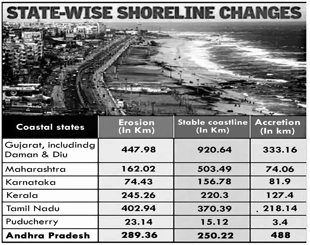
Figure: Coastal Erosion in India
Causes of Coastal Erosion
| NATURAL | ARTIFICIAL |
| a) Action of breaking waves | a) Construction of unplanned structures |
| b) Effect of severe cyclonic storms | b) Reduction of sediment supply due to damming of rivers |
| c) Rise in sea level | c) Removal of sand from beaches |
| d) Deflation | d) Dredging of inlet channels |
| e) Tidal current | e) Unplanned reclamation |
• Nature: Wave energy and Natural hazards like cyclones, thermal expansion of seawater, storm surges, tsunami etc due to the melting of continental glaciers and ice sheets as a result of climate change hamper the natural rhythm and precipitate erosion.
Coastal Erosion Mitigation Measures
•
Sand Movement: Strong littoral drift resulting in sand movement can also be considered as one of the major reasons for coastal erosion. Littoral drift means the natural movement of sediment along marine or lake shorelines by wave action in response to prevailing winds.
• Human Factors: Dredging, sand mining and coral mining have contributed to coastal erosion causing sediment deficit, modification of water depth leading to longshore drift and altered wave refraction. Coastal erosion has been sparked by fishing harbours and dams constructed in the catchment area of rivers and ports reducing the flow of sediments from river estuaries.
Impact of Coastal Erosion
• East coast of India has been impacted by erosion by the sea over the last few years, with some of them being completely engulfed by the sea as well.
• In addition to recurring cyclones, human-made structures such as dams and ports have aggravated coastal erosion.
• Economic impacts - Loss of property, impact on fisheries and tourism sector.
• Environmental impacts - destruction of animal habitats.
• Coastal features like dunes and mangroves provide a natural defence against several hazards, including tsunamis and storm surges, so their loss due to erosion may signal an increase in vulnerability from these hazards.
• Disaster induced erosion will cause rapid erosion equating years of non-disaster linked erosion.
• Resettled population as “climate refugees” where the original inhabitants of a region are made refugees because of climate-induced causes like the example of Satabhaya village in Kendrapara district, Odisha.
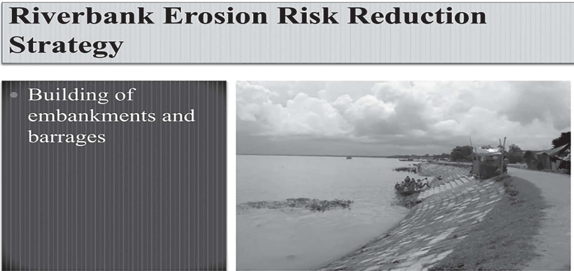
• Hard Engineering Options (such as building sea walls, revetments and groynes)
• Groyens and Breakwaters: These are structures that are built perpendicular to the shore to trap sand and protect against erosion.
• Soft Shore Protection: This involves the use of natural materials such as vegetation or sand-filled bags to protect against erosion.
• Soft Engineering Options (such as beach nourishment and managed retreat).
• Beach Nourishment: This involves the addition of sand to the beach to restore its natural slope and protect against erosion.
• Control of Beach Groundwater Table or Beach Dewatering System.
• Vegetation Planting like Mangroves and creation of Shelter Belts.
• Use of Geo-synthetic Tubes / Bags.
• Coastal Zoning: This involves the careful planning of development along the coast to minimize the impact on natural shoreline process. Coupling GIS and remote sensing techniques be used for coastal zone disaster management.
• Coastal Management through legal mechanisms like Eco Sensitive Zones, Coastal Regulatory Zones and creation of Marine Protected Areas.
Steps Taken to Mitigate Coastal Erosion
• National Disaster Management Authority (NDMA) in 2023 is working on the draft of India’s first National Policy for The Mitigation and Rehabilitation of the people affected by River and Coastal Erosion, based on the 15th Finance Commission’s report for 2021.
• Earlier, the Indian National Centre for Ocean Information Services (INCOIS) had prepared and published an atlas of Coastal Vulnerability Index (CVI) maps for the entire coastline of India using seven input parameters:
shoreline change rate, sea-level change rate, coastal elevation, coastal slope, coastal geomorphology, significant wave height and tidal range.
• Innovative methods including Tetrapod used in Kerala
are very effective to prevent coastal erosion.
• National Centre for Sustainable Coastal Management (NCSCM): It aims to promote integrated and sustainable management of the coastal and marine areas in India for the wellbeing of the traditional coastal and island communities.
• Integrated Island Management Plan (IIMP):
• Conserve and protect of Islands unique environment and its marine areas
• Provide livelihood security to the local communities
• Promote sustainable development based on scientific principles taking into account the dangers of natural hazards, sea level rise due to global warming
• Integrated Coastal Zone Management Plan (ICZMP): Management of the coast using an integrated approach, regarding all aspects of the coastal zone to achieve sustainability.
• Detailed hazard assessments carried out by central agencies such as the National Centre for Coast Research, National Centre for Sustainable Coastal Management, Central Water Commission and, high-resolution LiDAR data available with National Remote Sensing Centre should be made available to the SDMAs. These should be made available in easy-to-access in Geographic Information Systems (GIS) formats by the NDMA.
• Government has identified 98 coastal erosion hotspots in 11 coastal states/UTs.
• The Ministry of Environment Forest & Climate Change has issued the Coastal Regulation Zone (CRZ) 2019 notification with a view to conserve and protect the unique environment of the coastal stretches and marine areas, besides livelihood security to the fisher communities and other local communities in the coastal areas.
Nodal Ministry for Management / Mitigation of Different Disasters
| Disaste | Nodal Ministry/ Department |
| Biological | Ministry of Health and Family Welfare (MoHFW) |
| Chemical and Industrial | Ministry of Environment, Forests and Climate Change (MoEFCC) |
| Civil Aviation Accidents | Ministry of Civil Aviation (MoCA) |
| Cyclone/Tornado | Ministry of Earth Sciences (MoES) |
| Tsunami | Ministry of Earth Sciences (MoES) |
| Disaste | Nodal Ministry/Department |
| Drought/Hailstorm/Cold Wave and Frost/Pest Attack | Ministry of Agriculture and Farmers Welfare (MoAFW) |
| Earthquake | Ministry of Earth Sciences (MoES) |
| Flood | Ministry of Water Resources (MoWR) |
| Forest Fire | Ministry of Environment, Forests, and Climate Change (MoEFCC) |
| Landslides | Ministry of Mines (MoM) |
| Avalanche | Ministry of Defence (MoD) |
| Nuclear and Radiological Emergencies | Department of Atomic Energy (DAE) |
| Rail Accidents | Ministry of Railways (MoR) |
| Road Accidents | Ministry of Road Transport and Highways (MoRTH) |
| Urban Floods | Ministry of Urban Development (MoUD) |