Self-driven
Self-driven
Community-Based Disaster Management (CBDM) has been practiced for generations. Communities have relied on their inherent coping mechanisms, which they have developed over t
Community-Based Disaster Management (CBDM) has been practiced for generations. Communities have relied on their inherent coping mechanisms, which they have developed over time to ensure survival.
These coping strategies are rooted in people's observations of their surroundings, including environmental changes and their impacts. Through these observations, communities have adapted their actions to coexist more effectively with nature.
The following example from modern times demonstrates how a community has learned from its environment and taken proactive measures to safeguard it, thereby reducing disaster risks (FAO).
Chipko: from tree hugging to satellite images
The Uttaranchal region, consisting of Himalayan districts in northern India, underwent a major road development initiative in the late 1960s. This project created employment opportunities for local residents and facilitated greater connectivity with the outside world. It also enabled the inflow of new technologies and materials while providing an avenue for monetizing natural resources like timber. Large tracts of forest land were leased to contractors for logging, with local workers employed in the felling operations. However, vast slopes above the road level were completely stripped of trees. While the economy initially thrived, little attention was paid to the environmental consequences of extensive deforestation. The removal of trees weakened the forest soil, and the intensity of rainwater runoff carrying debris and stones increased significantly.
On a monsoon night in 1970, the Alaknanda River, which flows through the region, experienced a catastrophic flood. The entire village of Belakuchi was wiped out by the raging waters, along with several buses carrying tourists. The flood impacted an area spanning
400 kilometers, destroying five major bridges, killing hundreds of livestock, and causing property losses worth millions of rupees. Eyewitnesses recall the terrifying sight of the river appearing to be "on fire," as the powerful currents carried massive boulders that struck against each other, creating loud, thunderous noises and emitting bright sparks.
The devastation extended to the plains as well. The flash flood not only swept away everything in its path but also left the land buried under silt and large rocks. Major canal networks became clogged, and the prolonged desilting process resulted in reduced irrigation, leading to a sharp decline in agricultural output in downstream areas that year. Local communities quickly realized that the disappearance of forests would not only lead to economic struggles and increased threats from wildlife like man- eating tigers but also bring more severe challenges in the form of floods, landslides, and the drying up of once-
perennial streams.
The response was instinctive and straightforward— Chipko, meaning "hug the trees." This was the method chosen by the local community to protect their forests from timber contractors. A major milestone in the movement occurred on March 26, 1974, when 27 women from Reni village in Chamoli district, led by Gaura Devi,
a 50-year-old illiterate woman, physically embraced 2,451 trees in the Reni forest to prevent them from being cut down. The women of Reni played a crucial and dramatic role in resisting deforestation, marking a turning point in the Chipko movement.
It gained much acclaim for being a totally community led initiative, without any involvement of outside agencies, not even NGOs. Tree felling has since been totally controlled, and afforestation drives have yielded some positive results in terms of regeneration of forests on the denuded slopes. However, more important than the achievements of the programme; are its means.
There are two highlighting features of this aspect:
Van Panchayats (forest governing councils) are an innovative institutional instrument constituted on the pattern of the Panchayats or the rural local governments. The elected Van Panchayat is responsible for the maintenance of the village forestland. It monitors and controls all activities in the forest, including woodcutting and even grazing of cattle. An interesting fact is that over the years, the Van Panchayats have come to be totally dominated by women. This, they feel is very logical since the hardships of environmental degradation affect women the most since women are responsible for getting firewood for cooking, fetching drinking water from faraway sources, and grazing the animals.
The Dasholi Gram Swarajya Mandal (DGSM) emerged as a resilient community-based organization following the Chipko movement. Over time, it has played a crucial role in not only fostering forest regeneration efforts but also promoting local
entrepreneurship rooted in sustainable resource utilization. Notably, DGSM, which is entirely composed of local villagers, has been actively tracking the progress of its afforestation initiatives using satellite imagery and remote sensing technology facilitated by the Indian Space Research Organisation (ISRO). The organization advocates for disaster prevention through sustainable development and conducts awareness campaigns on the subject. Additionally, DGSM serves as the first line of response during local disasters, including landslides, earthquakes, and forest fires.
These coping strategies are rooted in people's observations of their surroundings, including environmental changes and their impacts. Through these observations, communities have adapted their actions to coexist more effectively with nature.
The following example from modern times demonstrates how a community has learned from its environment and taken proactive measures to safeguard it, thereby reducing disaster risks (FAO).
Chipko: from tree hugging to satellite images
The Uttaranchal region, consisting of Himalayan districts in northern India, underwent a major road development initiative in the late 1960s. This project created employment opportunities for local residents and facilitated greater connectivity with the outside world. It also enabled the inflow of new technologies and materials while providing an avenue for monetizing natural resources like timber. Large tracts of forest land were leased to contractors for logging, with local workers employed in the felling operations. However, vast slopes above the road level were completely stripped of trees. While the economy initially thrived, little attention was paid to the environmental consequences of extensive deforestation. The removal of trees weakened the forest soil, and the intensity of rainwater runoff carrying debris and stones increased significantly.
On a monsoon night in 1970, the Alaknanda River, which flows through the region, experienced a catastrophic flood. The entire village of Belakuchi was wiped out by the raging waters, along with several buses carrying tourists. The flood impacted an area spanning
400 kilometers, destroying five major bridges, killing hundreds of livestock, and causing property losses worth millions of rupees. Eyewitnesses recall the terrifying sight of the river appearing to be "on fire," as the powerful currents carried massive boulders that struck against each other, creating loud, thunderous noises and emitting bright sparks.
The devastation extended to the plains as well. The flash flood not only swept away everything in its path but also left the land buried under silt and large rocks. Major canal networks became clogged, and the prolonged desilting process resulted in reduced irrigation, leading to a sharp decline in agricultural output in downstream areas that year. Local communities quickly realized that the disappearance of forests would not only lead to economic struggles and increased threats from wildlife like man- eating tigers but also bring more severe challenges in the form of floods, landslides, and the drying up of once-
perennial streams.
The response was instinctive and straightforward— Chipko, meaning "hug the trees." This was the method chosen by the local community to protect their forests from timber contractors. A major milestone in the movement occurred on March 26, 1974, when 27 women from Reni village in Chamoli district, led by Gaura Devi,
a 50-year-old illiterate woman, physically embraced 2,451 trees in the Reni forest to prevent them from being cut down. The women of Reni played a crucial and dramatic role in resisting deforestation, marking a turning point in the Chipko movement.
It gained much acclaim for being a totally community led initiative, without any involvement of outside agencies, not even NGOs. Tree felling has since been totally controlled, and afforestation drives have yielded some positive results in terms of regeneration of forests on the denuded slopes. However, more important than the achievements of the programme; are its means.
There are two highlighting features of this aspect:
Van Panchayats (forest governing councils) are an innovative institutional instrument constituted on the pattern of the Panchayats or the rural local governments. The elected Van Panchayat is responsible for the maintenance of the village forestland. It monitors and controls all activities in the forest, including woodcutting and even grazing of cattle. An interesting fact is that over the years, the Van Panchayats have come to be totally dominated by women. This, they feel is very logical since the hardships of environmental degradation affect women the most since women are responsible for getting firewood for cooking, fetching drinking
water from faraway sources, and grazing the animals.
The Dasholi Gram Swarajya Mandal (DGSM) emerged as a resilient community-based organization following the Chipko movement. Over time, it has played a crucial role in not only fostering forest regeneration efforts but also promoting local
entrepreneurship rooted in sustainable resource utilization. Notably, DGSM, which is entirely composed of local villagers, has been actively tracking the progress of its afforestation initiatives using satellite imagery and remote sensing technology facilitated by the Indian Space Research Organisation (ISRO). The organization advocates for disaster prevention through sustainable development and conducts awareness campaigns on the subject. Additionally, DGSM serves as the first line of response during local disasters, including landslides, earthquakes, and forest fires.
Disaster Risk
Disaster Management is essentially Disaster Risk Management, encompassing all activities, programs, and measures undertaken before, during, and after a disaster. The objective is to prevent disasters, minimize their impact, or recover from their consequences
Disaster management involves three critical phases:
1) Pre-Disaster Phase – Implementing measures to reduce human, material, and environmental losses and ensuring preparedness to minimize damage when a disaster occurs.
2) During Disaster Phase – Providing relief and support to affected individuals to alleviate suffering and address urgent needs.
3) Post-Disaster Phase – Facilitating rapid and sustainable recovery, ensuring that pre-existing vulnerabilities are not re-created.
• The Disaster Risk Management process follows a cyclical framework known as the Disaster Management Cycle, which consists of six key stages: Prevention, Mitigation, Preparedness, Response, Recovery, and Reconstruction.
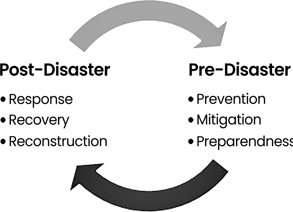
Figure: Pre and Post Disaster Management
• Disaster Risk
• Risk refers to the likelihood of an event occurring and its potential adverse effects. It represents the possibility of a disaster that may result in loss of lives, damage to property, and destruction of infrastructure.
•
The term "risk" has two distinct interpretations:
• 1) General Understanding – It emphasizes the probability or possibility of an occurrence, such as in "the risk of an accident".
• 2) Technical Perspective – It focuses on the potential consequences and losses related to a specific event, location, and time frame. It is important to note that perceptions of risk vary among individuals and communities based on their understanding and experiences.
• Risk is influenced by three key factors:
• The presence of a hazard (a situation posing a threat),
• The level of vulnerability (physical, socio-economic, and environmental capacity to cope),
• Exposure to risk-prone structures within a community.
The intersection of these three elements defines risk.

Figure: Identification of Risk
Disaster Risk refers to the potential losses in terms of lives, health, livelihoods, assets, and essential services that a particular community or society might experience within a defined future period.
The definition of disaster risk reflects the concept of disasters as the outcome of continuously present conditions of risk. Disaster risk comprises different types of potential losses which are often difficult to quantify.
Nevertheless, with knowledge of the prevailing hazards and the patterns of population and socio- economic development, disaster risks can be assessed and mapped, in broad terms at least.
A single disaster has a different impact on different people in the society. Poor people have less capacity to cope with the disaster in comparison to rich people. Because poor people have less strong houses constructed in low economic zones, situated in low lying areas with less economic power.
All are making them more vulnerable to any disaster. They are more exposed to nature and subject to risk. On the other hand, the reverse is the case with rich people. Therefore, risk is determined by hazard, vulnerability and exposure of the people to the disaster.
Exposure: People, property, systems or other elements present in hazard zones that are thereby subject to potential losses.
Measures of exposure can include the number of people or types of assets in an area. These can be combined with the specific vulnerability of the exposed elements to any particular hazard to estimate the quantitative risks associated with that hazard in the area of interest.

Disaster Risk Assessment or Analysis
Disaster Risk Assessment or Analysis
• A methodology to determine the nature and extent of risk by analysing potential hazards and evaluating existing conditions of vulnerability that together could potentially harm exposed people, property, services, livelihoods and the environment on which they depend.
• Risk assessments (and associated risk mapping) include:
• A review of the technical characteristics of hazards such as their location, intensity, frequency and probability;
• The analysis of exposure and vulnerability including the physical, social, health, economic and environmental dimensions;
• The evaluation of the effectiveness of prevailing and alternative coping capacities in respect to likely risk scenarios. This series of activities is sometimes known as a risk analysis process.
• A qualitative or quantitative approach to determine the nature and extent of disaster risk by analysing potential hazards and evaluating existing conditions of exposure and vulnerability that together could harm people, property, services, livelihoods and the environment on which they depend.
• Steps in Risk Assessment: Risk Assessment (RA) consists of the following steps

Figure: Steps of disaster assessment
Hazard Assessment: This stage involves identifying past and potential hazards in a given area. It serves as the foundation for subsequent assessments since different hazards require distinct methods and tools for evaluation.
For instance, earthquake analysis necessitates specific instruments and expertise, which differ from those used for landslides or floods.
The assessment further involves examining the frequency, seasonal patterns, magnitude, intensity, geographical spread, and underlying causes of these hazards.
Vulnerability Assessment: This step focuses on identifying elements at risk, assessing their level of vulnerability, and understanding the factors contributing to their susceptibility.
It involves creating an inventory of all potentially affected elements such as people, buildings, and resources.
The degree of vulnerability of these elements is then evaluated, along with factors that increase their risk exposure.
Additionally, a critical facility analysis is conducted to assess the vulnerability of essential infrastructures like hospitals, schools, religious centers, and civic buildings that play a vital role in daily life.
This analysis also includes reviewing historical records of hazard occurrences in these key facilities to understand their exposure and susceptibility to future disasters.
Capacity Assessment: Capacity Assessment refers to the process of identifying the existing strengths and resources that can help mitigate risks or lessen the impact of a disaster. This involves evaluating a community's resources, including skills, expertise, equipment, and infrastructure.
Additionally, the availability and readiness of these resources are assessed to determine how quickly they can be mobilized and utilized in times of need.
Another important step is to find out how durable and long lasting these resources are and what is the level of their operational integrity (Ability to complete tasks without supervision).
4. People’s perception of Risk: The process of finding out the perceptions of heterogeneous groups in the community regarding the disasters, hazards and risks that they are facing
Risk Management
Risk Management
• Risk management refers to a systematic approach used to handle uncertainties with the goal of minimizing potential harm and losses.
• It involves risk assessment, analysis, and implementation of strategies to control, reduce, or transfer risks.
• Organizations commonly practice risk management to minimize financial risks, mitigate operational disruptions, prevent environmental damage, and address social impacts.
• It is particularly critical in sectors like water supply, energy, and agriculture, where production is directly impacted by extreme weather conditions and climate variations.
Disaster Risk Management: Disaster risk management is the structured process of utilizing administrative policies, organizational efforts, and operational skills to develop strategies that enhance preparedness and reduce disaster-related losses.
It extends the broader concept of risk management,
focusing specifically on disaster risks.
The main objective is to prevent, mitigate, or transfer the adverse effects of hazards through prevention, preparedness, and mitigation measures.
Risk Evaluation: Risk evaluation involves the social and political assessment of the significance and impact of risks as perceived by individuals and communities.
It requires prioritizing risks, which often involves political considerations due to the need for resource allocation among competing interests.
The process includes weighing risks against benefits, incorporating scientific assessments, personal beliefs, and other influencing factors in decision-making.
Risk Mapping
Risk Mapping
Risk Representation Through Mapping: Risks can be effectively illustrated using maps, which help in visualizing potential threats. Various methods have been developed to accurately estimate risks, including f:N curves, scenario mapping, and potential loss studies, as outlined in the Disaster Management Training Programme by UNDP.
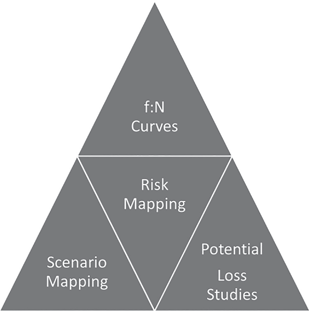
Figure: Aspects of Risk Mapping
• f:N Curves
• The “f” represents the frequency of a disaster event, while “N” refers to the number of casualties in a particular country. These values can be plotted as f:N curves.
• However, such curves only show aggregate losses over a period of time for a large region. They do not provide a detailed geographical distribution of the damage, making risk mapping essential.
• Analyzing data from 1900 to 1975, it is evident that natural disasters have caused significantly greater losses compared to man-made calamities such as transportation accidents or industrial fires.
• Scenario Mapping
• Scenario mapping aims to illustrate the impact of a single hazard.
• It utilizes circles and shaded areas on maps to represent different building types, population densities, and settlement areas. This method helps in assessing the extent of damage in specific locations based on historical data and recent developments.
• A scenario map identifies "communities at risk" and "regions at risk," highlighting areas that require restoration and recovery efforts after a disaster.
• These maps also help determine the resources needed for medical assistance, emergency shelters, and other disaster response measures to reduce the recovery time.
• For example, scenario mapping has been used to assess the potential impact of a 7.2 magnitude earthquake in Bursa Province, Turkey. However, this technique does not provide a precise prediction but rather an assessment based on past occurrences and existing vulnerabilities.
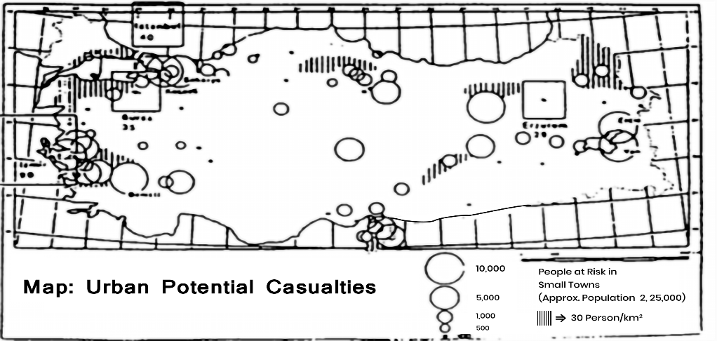
• This type of exercise is essential for preparedness planning in the event of an earthquake. The top section, located near the Marmara Sea, represents the Gemlik area, which is expected to experience severe damage. The left section corresponds to the Mudanya area, where moderate damage is anticipated. The central section illustrates the Bursa province, projected to suffer significant destruction, while the right section highlights the Yenisihir area, also expected to face heavy damage.
| TOTAL | Villages | Towns | Bursa City | Total |
| Houses lightly damaged | 34,000 | 21,000 | 50,000 | 105,000 |
| Houses heavily damaged | 15,000 | 9,000 | 30,000 | 54,000 |
| Houses collapsed | 4,000 | 2,000 | 6,000 | 12,000 |
| People killed | 2,000 | 800 | 1,500 | 4,300 |
| People injured | 6,000 | 2,500 | 4,500 | 13,000 |
| People Homeless | 73,000 | 36,000 | 13,000 | 122,000 |
Potential Loss Studies:
Mapping the potential impact of a hazard across a region or country helps identify communities that are most vulnerable to significant losses. The effects of the hazard are assessed for each area to determine which communities face the highest risk.
This approach highlights, for instance, the towns or villages that are expected to experience the most severe losses, enabling prioritization for loss reduction initiatives and ensuring that the most at-risk areas receive necessary aid and rescue assistance in the event of disasters of varying magnitudes.
Annualised Risk Mapping:
The annualized specific risk of any hazard at a given location represents the average anticipated total losses from all events over a set period. It is calculated by combining the probability of different hazard levels occurring within a specific timeframe with the consequences of each level of hazard, estimating the potential losses for that duration.
By summing the losses from all hazard levels, the total expected losses over time can be determined.
An annualized risk map illustrates the distribution of damage over both time and geographical areas, showing regions with concentrated damage over a year. This is expressed as a proportion of the total population or assets at risk.
| LOSS PARAMETERS FOR RISK ANALYSIS | |||
| Consequences | Measure | Tangible | Intangible |
| Deaths | Number of People | Loss of economically active individuals | Social and psychological consequences |
| Injuries | Number and injury severity | Medical treatment needs, temporary loss of employment activity by productive individuals | Social and psychological pain and recovery |
| Physical damage | Inventory of damage elements by number and damage level | Replacement and repair cost | Cultural losses |
| Emergency operations | Volume of manpower, man days employed, equipment and resources expended for relief | Mobilisation costs, investment and preparedness capability | Stress and overwork on relief participants |
| Disruption to economy | Number of working days lost, volume of production lost | Value of lost production | Opportunities, competitiveness reputation, |
| Social disruption | Number of displaced persons, homeless | Temporary housing relief, economic production | Psychologicalsocialcontacts, cohesion, community morale |
| Environmental impact | Scale and severity | Clean-up costs, repair costs | Consequences of poorer Environment, health risks, risk of future disaste |
Disaster Risk Reduction (DRR)
Disaster risk reduction refers to the systematic formulation and implementation of policies, strategies, and measures aimed at minimizing vulnerabilities, hazards, and the impact of disasters across society, all within the framework of sustainable development.
• It involves the concept and practice of lowering disaster risks through structured efforts to assess and address their root causes. This includes reducing exposure to hazards, decreasing the vulnerability of individuals and assets, ensuring responsible land and environmental management, and enhancing preparedness and adaptability to adverse events, including those linked to climate change.
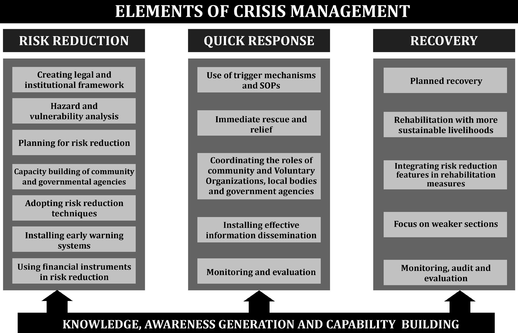
Figure: Elements of Crisis Management
• A holistic approach to minimizing disaster risks is outlined in the Hyogo Framework for Action, endorsed by the United Nations and adopted in 2005. Its intended goal is the significant reduction of disaster- related losses, including human lives and the social, economic, and environmental assets of communities and nations.
• The International Strategy for Disaster Reduction (ISDR) system serves as a platform for collaboration among governments, organizations, and civil society stakeholders to support the execution of this framework.
• While the term “disaster reduction” is sometimes used, “disaster risk reduction” is more appropriate as it acknowledges the continuous nature of disaster risks and the ongoing efforts needed to mitigate them.
• Adaptation refers to the process of adjusting natural or human systems in response to actual or anticipated climatic influences and their effects, thereby reducing harm or maximizing beneficial
opportunities.
• This concept, which primarily addresses climate change concerns, originates from the United Nations Framework Convention on Climate Change(UNFCCC).
• However, adaptation also applies to non-climatic challenges such as soil erosion or land subsidence. It can occur naturally, for instance, through market- driven changes, or it can be facilitated through deliberate policies and planning.
• Many disaster risk reduction strategies play a direct role in enhancing adaptation efforts.
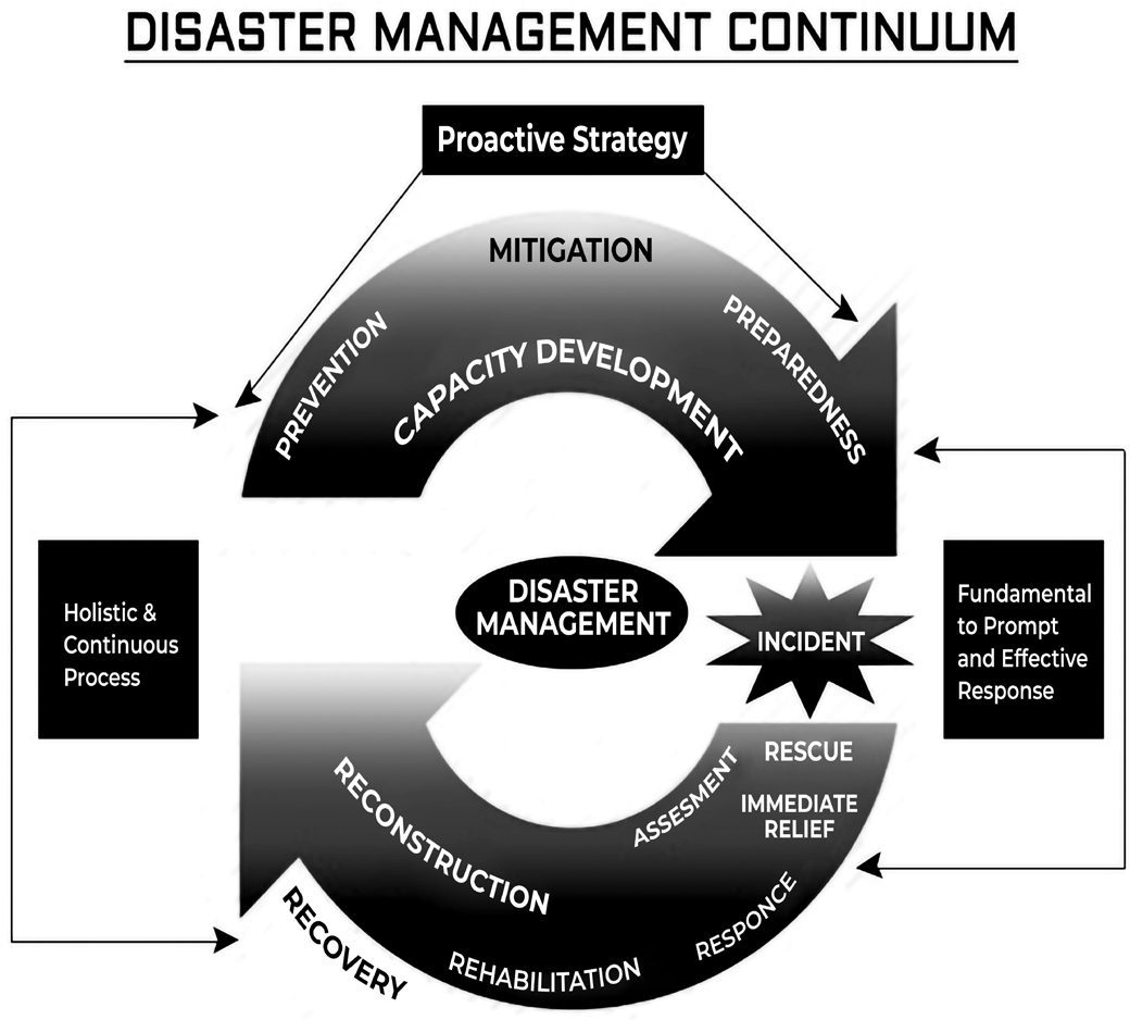
Figure: Disaster Management Continuum
Four Phases of Disaster Management Cycle
Four phases of Disaster Management cycle
Disaster Mitigation
Disaster Preparedness
Disaster Response
Disaster Recovery
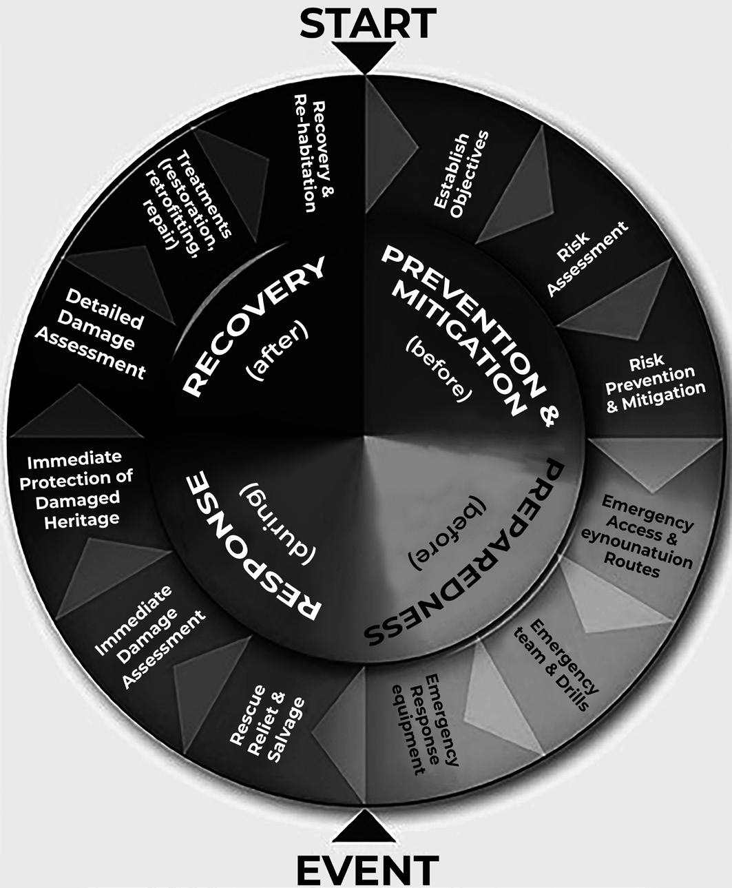
Disaster Mitigation
Disaster Mitigation/Prevention
Mitigation: It is defined as the lessening or limitation of the adverse impacts of hazards and related disasters.
Disaster Mitigation refers to activities carried out before or after a disaster occurs to prevent/minimize the effects. For example, hazard and vulnerability assessment, infrastructure improvement etc.
Although the negative effects of hazards cannot always be completely prevented, their intensity and impact can be significantly reduced through various strategies and actions. Mitigation efforts include the use of engineering solutions, hazard-resistant construction techniques, improved environmental policies, and increased public awareness.
It is important to note that in the context of climate change policy, the term "mitigation" has a different meaning. It refers to efforts aimed at reducing greenhouse gas emissions, which are the primary contributors to climate change.
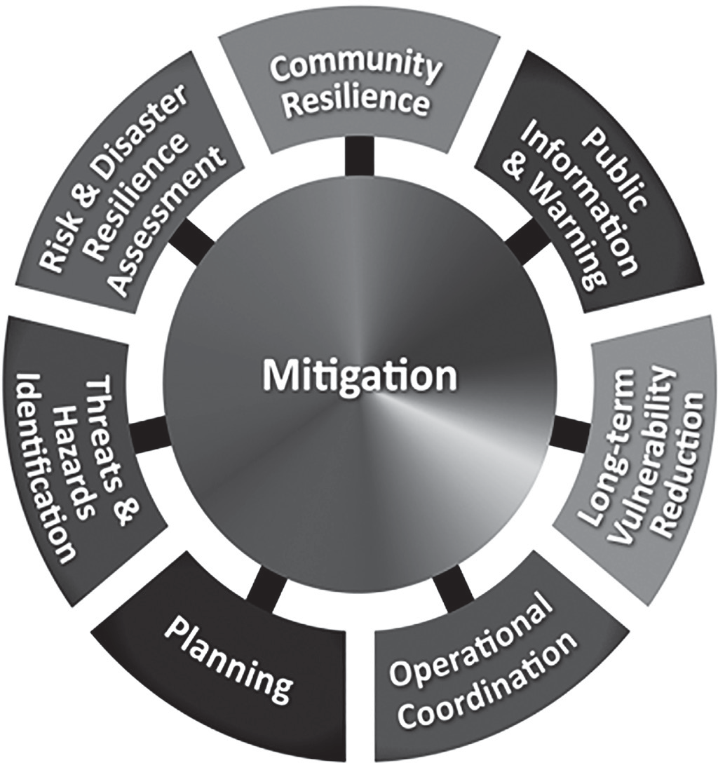
Figure: Disaster Mitigation
• Mitigation relies on integrating suitable measures into national and regional development plans.
• Its success is also contingent on the availability of information about hazards, potential emergencies, and appropriate countermeasures.
• The mitigation phase, as well as the broader disaster management cycle, involves shaping public policies and plans that either address the root causes of disasters or minimize their effects on people, property, and infrastructure.
• Mitigation focuses on:
• Implementing pre-disaster preparedness and preventive measures to aid community recovery.
• Reducing hazards that pose risks to communities.
• Raising awareness of potential risks at the local level.
• Encouraging community participation in risk reduction efforts.
• Safeguarding and preserving natural resources.
• Conducting risk and vulnerability assessments to identify threats and develop strategies for risk reduction.
• Developing an effective disaster mitigation program with the involvement of governments, communities, NGOs, the private sector, and international organizations. For instance, an effective tsunami warning system requires cooperation among the 36 Indian Ocean countries to share crucial data, ensuring sufficient time for coastal populations to be alerted and take necessary precautions.
•
Prevention refers to the complete avoidance of negative impacts caused by hazards and disasters.
• Disaster prevention entails proactive measures to entirely eliminate potential risks before they occur. Examples include constructing dams or embankments to prevent flooding, enforcing land- use policies that prohibit settlements in high-risk zones, and implementing seismic engineering techniques to ensure that critical buildings remain functional during earthquakes.
• In many cases, complete risk avoidance is not feasible, shifting the focus to mitigation efforts instead. Due to this overlap, the terms "prevention" and "mitigation" are sometimes used interchangeably in informal discussions.
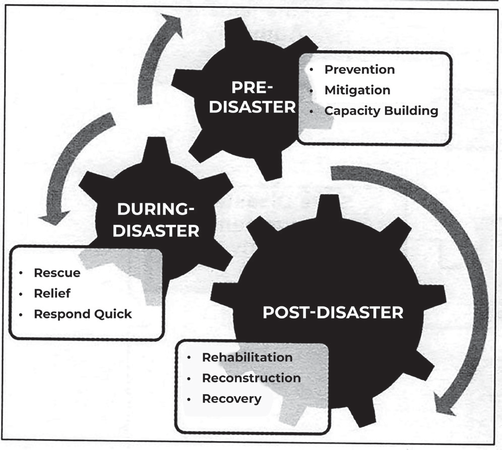
Figure: Pre, During and Post- Disaster Management Processes
• Environmental Impact Assessment (EIA) is a process used to evaluate the potential environmental effects of a proposed project or program. It is an essential part of planning and decision-making, aimed at minimizing or mitigating any adverse environmental impacts.
• EIA serves as a policy instrument that offers evidence- based analysis of environmental consequences from the early stages of a project through decision-making. It is widely applied in national development planning, project approval processes, and international development initiatives.
• A comprehensive Environmental Impact Assessment should include thorough risk evaluations and propose alternatives, solutions, or strategies to address identified environmental concerns.
• Hazard Mapping for Prevention
• Hazard Mapping is explained as “the process o festablishing geographically, where and to what
extent, particular phenomena are likely to pose a threat to people, property, infrastructure, and economic activities. Hazard mapping represents the result of hazard assessment on a map, showing the frequency or probability of occurrences of various magnitudes or occurrences” (DMTP, 1994).
• Two parameters are used in hazard maps, event
parameter (intensity of the hazard), and site parameter (physical characteristics of the area), since the physical characteristics of the area with respect to that particular hazard determine the extent of losses that would be suffered in the event of an actual disaster. Event parameters give the nature of the hazard and site parameters give the impact that is likely in the event of a disaster.
| Natural Hazards | Event Parameters | Site Parameters |
| Flood | Area Flooded (Km2) Volume of Water (m3) | Depth of Water (meters) |
| Earthquake | Energy Release (Magnitude) | Intensity of Ground Shaking (modified Mercalli /MSK intensity) Peak Ground Acceleration. |
| Volcano | Eruption size and duration | Potential to be affected by ash coverage (m); lava; dust fallout; debris flow |
| Strong Winds | Wind velocity (Km/h) Area | Wind velocity (km/hr) |
| Landslide | Volume of material dislodged | Potential for ground failure; ground displacement (meters) |
| Tsunami | Height of wave crest | Depth of flood water (meters) |
| Drought | Area affected (Km2) | Rainfall deficit (mm) |
• A Flood Hazard Map illustrates the maximum impact of floods by overlaying different return periods, providing insights into both the probability of occurrence and the potential effects across various geographical locations.
• A Volcanic Hazard Map delineates areas with varying degrees of risk. Although assessing volcanic hazards is more complex compared to other natural disasters, specific zones can be identified. Regions closest to the volcano’s summit are strictly off-limits for habitation. A designated perimeter, such as 20 km, is considered vulnerable to pyroclastic surges
(volcanic debris in the air) and lahars (lava flows), necessitating evacuation during eruptions. Lower slopes, which are potential mudflow channels, are classified as secondary danger zones. Advancements in satellite imagery now enable the identification of these mudflow paths through remote sensing and historical data analysis.
• The effectiveness of hazard mapping relies on the availability of historical data, which facilitates the creation of Micro-Zonation Maps and Vulnerability Atlases. These resources provide comprehensive details about the susceptibility of various regions to multiple hazards, aiding in risk assessment and preparedness planning.
Disaster Preparedness
Disaster Preparedness
• Preparedness refers to the knowledge and abilities cultivated by governments, professional response and recovery agencies, communities, and individuals to effectively foresee, respond to, and recover from the effects of potential, imminent, or ongoing hazard events or conditions.
•
Disaster preparedness involves readiness to respond to disasters, encompassing both emergency response and recovery planning.
• Preparedness efforts are undertaken within the framework of disaster risk management, aiming to develop the necessary capacities to efficiently handle emergencies and facilitate a smooth transition from response to long-term recovery.
• It is founded on a thorough analysis of disaster risks and strong integration with early warning systems. Preparedness activities include contingency planning, stockpiling essential supplies and equipment, establishing coordination mechanisms, planning for evacuation procedures, disseminating public information, and conducting related training and field exercises. These efforts must be backed by formal institutional, legal, and financial frameworks to ensure their effectiveness.
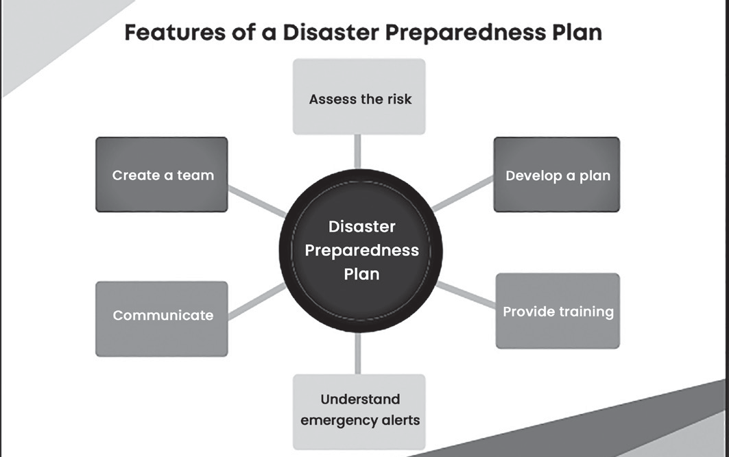
Figure: Disaster Preparedness Plan
• The term “readiness” refers to the capability to respond swiftly and effectively when needed.
• Disaster preparedness is an ongoing and systematic process that involves careful planning, assessment of resources, and evaluation of policy implementation. Given the broad scope of disaster preparedness and the involvement of multiple stakeholders, establishing a coordinated framework is crucial. Recognizing this necessity, the Government of India aims to transition from short-term relief efforts to long-term mitigation, preparedness, and prevention through the following measures:
• Institutional reforms
• Policy development
• Establishment of legal and techno-legal frameworks
• Integrating mitigation strategies into developmental planning
• Creating sustainable funding mechanisms
• Implementing specific mitigation-focused schemes
• Strengthening preparedness measures
• Capacity building initiatives
• Human Resource Development (HRD)
• Mostimportantl y,encouraging community participation.
The primary objective of Emergency Preparedness Programs is to attain an optimal level of readiness to handle emergencies by enhancing the technical and managerial competencies of governments, organizations, and communities.
These efforts fall under Logistical Readiness, which can be improved by establishing response mechanisms, conducting rehearsals, devising both short-term and long-term strategies, educating the public, and implementing early warning systems.
Preparedness also involves maintaining strategic reserves of essential supplies such as food, water, medicines and equipment to address national or local crises.
During this phase, individuals, organizations, and government bodies devise strategies to safeguard lives, reduce disaster impact and optimize emergency response operations.
Key preparedness measures include emergency response plans, training exercises, forecasting and warning systems, communication infrastructure,
evacuation protocols, resource assessments, emergency personnel directories, mutual aid agreements, and public awareness campaigns.
• Forecasting refers to a definitive statement or statistical estimate regarding the probable occurrence of a future event in a particular area. In meteorology, a forecast predicts future conditions, while a warning indicates a potential threat.
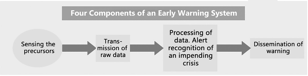
Figure: Components of an Early Warning System
• Early Warning Systems encompass the necessary capabilities to generate and disseminate timely and relevant warnings, enabling individuals, communities, and organizations at risk to take appropriate action and minimize potential harm.
• Effective early warning systems include essential components such as risk awareness, hazard monitoring and analysis, timely dissemination of alerts, and the capacity of local communities to respond.
The concept of an "end-to-end warning system" highlights the importance of covering all stages, from identifying hazards to ensuring an adequate community response
Disaster Response
Disaster Response
• Disaster Response is defined as the immediate action taken after a disaster occurs such as search and rescue operation, firefighting, providing relief like food, water, and shelter etc. Actions planned during preparedness are executed in response phase.
• Disaster response is predominantly focused on immediate and short-term needs and is sometimes called “disaster relief”. The division between this response stage and the subsequent recovery stage is not clear-cut. Some response actions, such as the supply of temporary housing and water supplies, may extend well into the recovery stage.
• Search and Rescue: Deployment of search and rescue teams to find the trapped people at the location of the disaster and take them to safe places. The escape route should be identified at the earliest to evacuate the stranded people.
• Relief: Relief is immediate support provided to minimize suffering and provide basic human needs such as food, water and shelter. Recovery is focused on restoring quality of life and community services to pre-disaster levels.
• Response: It is defined as the provision of emergency services and public assistance during or immediately after a disaster in order to save lives, reduce health impacts, ensure public safety and meet the basic subsistence needs of the people affected.
The focus in the response phase is on meeting the basic needs of the people until more permanent and sustainable solutions can be found.
Humanitarian organizations are often strongly present in this phase of the disaster management cycle.
Disaster Recovery
Disaster Recovery
• Recovery refers to the process of restoring and, where feasible, enhancing infrastructure, livelihoods, and living conditions in communities impacted by disasters. This phase also includes efforts to minimize future disaster risks.
• The rehabilitation and reconstruction phase begins immediately after the emergency phase concludes. Recovery efforts should be guided by pre-established strategies and policies that define institutional responsibilities and encourage public participation.
• The increased awareness and engagement of the public following a disaster provide a crucial opportunity to implement disaster risk reduction strategies and adopt the "Build Back Better" approach.
• The recovery process—comprising rehabilitation and reconstruction—aims to enhance the resilience of nations and communities. This is achieved by integrating disaster risk reduction strategies into infrastructure restoration, economic recovery, environmental revitalization, and the strengthening of essential community systems. It is important to
note that the term “community systems” does not imply any specific political framework.
• Disaster Recovery involves long-term efforts focused on restoring normalcy in affected areas.
• Recovery efforts persist until all systems are restored to their original state or improved.
• Both short-term and long-term recovery measures encompass restoring essential life-support systems to basic operational levels, providing temporary shelter,
disseminating public information, conducting health and safety awareness programs, rebuilding damaged infrastructure, offering counseling services, and assessing economic impacts.
• Information resources and services play a vital role in recovery, including data collection for reconstruction efforts and documenting lessons learned to improve future disaster response.
Since these activities are interconnected, an effective disaster management plan must ensure seamless coordination among all four phases—preparedness, response, recovery, and mitigation—to facilitate a comprehensive and efficient disaster response.
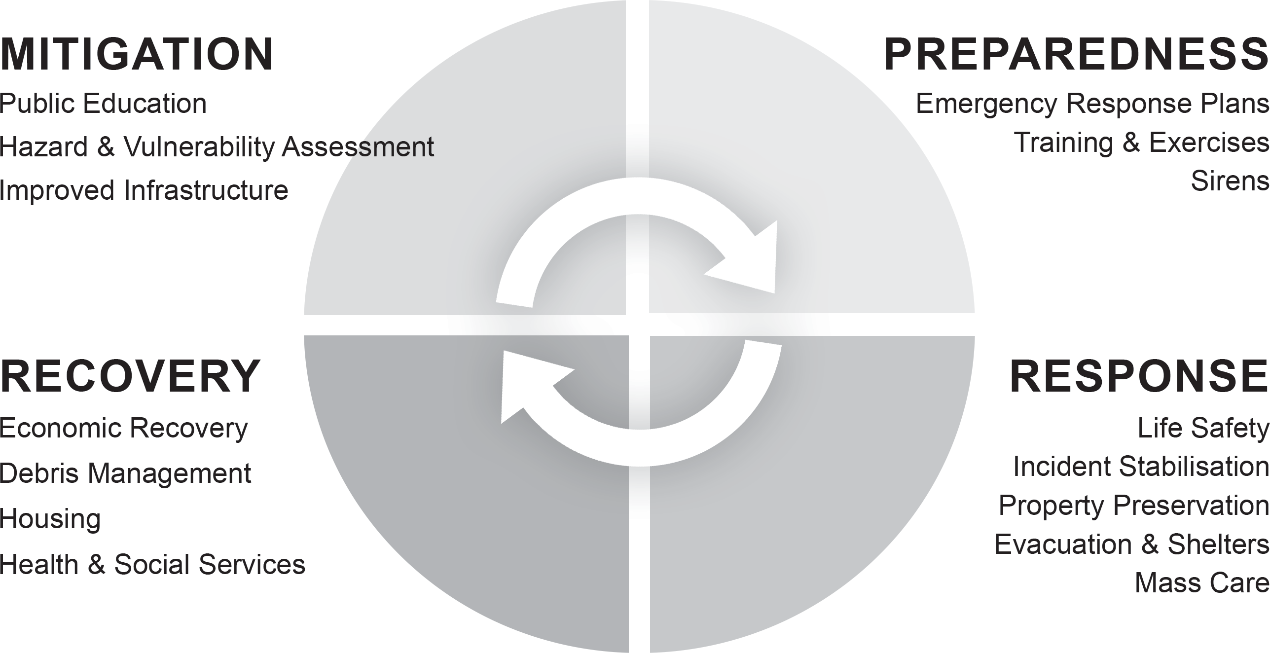
Figure : phases of disaster management cycle
Community-based Disaster Management (cbdm)
Community-Based Disaster Management (CBDM)
The term Community-Based Disaster Management refers to the process of mobilizing, involving and enabling the participation of the exposed community in the management of disaster covering all phases; from preparedness, mitigation to rescue, response, relief, rehabilitation and finally recovery. The community should be ready to accept the management of hazards as a way of life and prevent them from becoming disasters.
Objectives
• Community-Based Disaster Management is a very effective and vital tool for reducing the vulnerabilities of the population.
• It also equips the populace with necessary skill and knowledge to prevent the hazards from becoming disasters.
Basic Principles of CBDM
• Planning, implementation and management owned by community, led by local champions.
• Interventions begin by utilizing local resources, existing capacities and collaborative partnerships.
• The community evaluates available options and makes informed decisions.
• Programs are designed to strengthen local coping mechanisms.
•
Disaster preparedness is integrated into broader development initiatives.
• Sustainability remains a fundamental consideration throughout the process.
• Greater focus is placed on addressing the needs of particularly vulnerable groups.

Figure: Community Based Disaster Management
Need and Importance
The rationale for involving communities in disaster preparedness and mitigation activities is based on the following assumptions:
• Communities in disaster affected areas are the real sufferers and are the first responders as well.
• Communities in high-risk areas have often developed their own coping mechanisms and strategies to reduce the impact of disaster. It is important to appreciate this local knowledge and resources, and to build on them in order to improve the capacity of the people to withstand the impact of disasters.
• Ownership of Disaster Reduction should not be stripped from local people who would be left even more powerless in case external intervention does not occur.
• Involvement and participation of the communities will ensure a collective and coordinated action during emergencies.
• Building community leadership and a chain of trained community cadres through participatory approach can help harness the resilience and resourcefulness of the community to cope.
• Solution is sustainable if it comes from people themselves rather than thrusting upon them.
Role of Community in Disaster Management
Being the first to suffer, the affected community rises like a phoenix and also becomes first real time responder in any disaster situation ignoring the inherent differences and stratifications of the community. This ‘community spirit’ or the social capital is thus a crucial strength on which the community balances its existence in a disaster scenario.
Before a Disaster: The community can play a pivotal role in mitigation and preparedness of a disaster. Some of the activities in which the community can be roped in are as follows:
• Identification of the vulnerable areas
• Identification of the vulnerable population
• Aware of the past history
• Making Disaster Management Plans
• Local coping strategies
• Awareness Generation
• Community-Based Warning System
During Disaster: The community can play a vital role in the following stages during a disaster:
Search & Rescue
Evacuation
Medical First Response
Building and locating place for temporary shelters
Needs Analysis of the affected community
Management and Distribution of Relief
Identification of Vulnerable Groups’
Coordination with authorities/ NGOs
Reduces costs as it uses local material and wisdom
After a Disaster: The community can also play an important role in the rehabilitation and recovery phase where existing local coping strategies can be used for the maximum benefit as it:
• Reduces costs as it uses local material and wisdom
• Serves in Long-term Mitigation
• Helps in restoration of affected livelihoods and economy
Crisis and Disaster Prevention and Response Mechanism in India
Crisis/Disaster Prevention and Response Mechanism in India
• Over the centuries, local communities have developed their own indigenous strategies for survival. This vast repository of knowledge forms an integral part of the nation’s heritage.
• The Arthashastra, an ancient treatise on governance authored by Chanakya in the 4th century B.C., included a section on mitigation strategies to address famines. The application of modern crisis management techniques began in the late 1870s. Following Independence, relief efforts were implemented in regions affected by severe droughts.
• With the advent of the Green Revolution in the late 1960s, the need for famine relief measures declined. A comprehensive approach to drought management was introduced through the Drought Prone Areas Programme (DPAP).
• In 2005, disaster management legislation was formally established at the national level with the enactment of the Disaster Management Act, 2005.
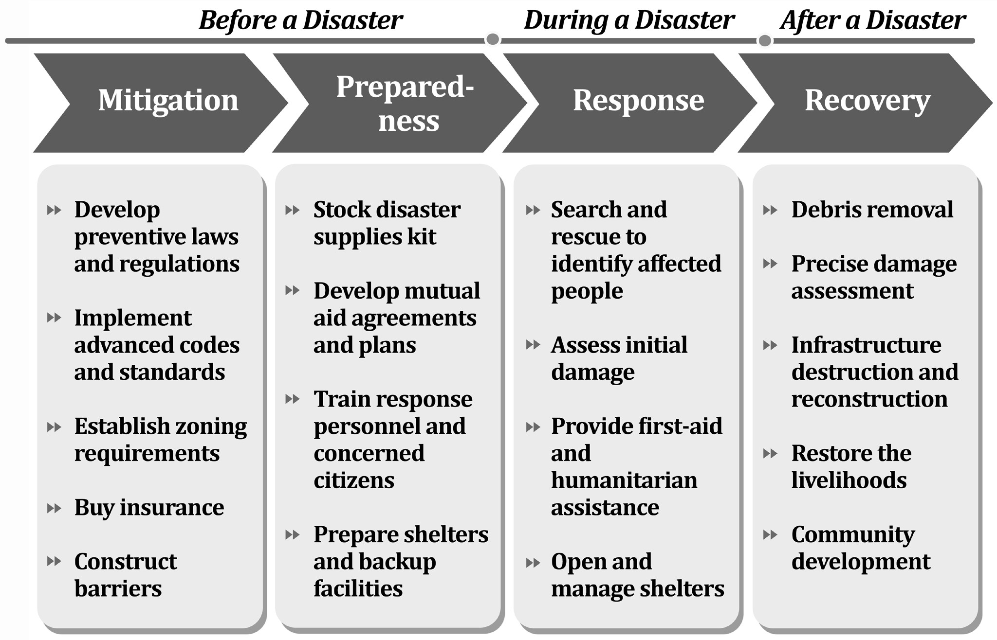
Figure: Practical Steps During Phases of Disaster Management
Disaster Prevention in India
• Following the Yokohama Strategy, India remains dedicated to disaster prevention policies. In 1994, the Ministry of Urban Development and Poverty Alleviation, Government of India, established an Expert Group to examine various aspects of natural hazard impacts, particularly concerning housing and infrastructure.
• The study emphasized the importance of identifying regions susceptible to natural disasters such as earthquakes, cyclones, and floods, which pose a threat to housing and infrastructure.
• A key objective was the development of a Vulnerability Atlas to map disaster-prone areas and assess the risk levels associated with different types of housing structures.
• Developing a strategic framework for establishing techno-legal regulations to ensure the enforcement of disaster-resistant construction and planning practices in human settlements vulnerable to natural hazards.
Disaster Response Mechanism
• In the event of a disaster, the community is typically the first to respond. In urban areas, response efforts are coordinated by agencies such as civic authorities, the fire department, and local law enforcement. However, panchayats currently lack the capacity to effectively respond to disasters.
• As a result, the district administration holds the primary responsibility for managing crisis situations, with the District Collector playing a key role.
• Within the Indian Constitution, "Disaster Management" is not explicitly listed under any of the three legislative lists. Matters not specifically mentioned in these lists fall under the Residuary Powers of the Union, as per Entry 97 of the Union List. While Parliament has the authority to legislate on this subject, in practice, the responsibility for disaster management primarily lies with State Governments.
State Governments act at the post disaster relief and rehabilitation stage.
Some states have established dedicated Disaster Management Departments.
A Cabinet Committee on Natural Calamities, led by the Chief Minister, oversees disaster situations and is responsible for making key policy decisions.
Each state has a Crisis Management Committee, chaired by the Chief Secretary, which monitors crisis situations daily during emergencies. This committee coordinates the efforts of various departments and provides decision-making support to the district administration.
Role of District Collector: The District Magistrate or Collector is responsible for overseeing disaster management within the district.
During a disaster, all state government departments, including police, fire services, public works, and irrigation, operate under the Collector’s leadership, except in metropolitan areas where municipal bodies play a key role. Additionally, the District Collector has the authority to request assistance from the Armed Forces if required.
• The Union Government primarily provides support by offering financial and physical resources, issuing early warnings, and coordinating efforts across various Union ministries, departments, and organizations.
• Previously, the Department of Agriculture was the nodal agency for disaster management. However, following the 2001 Gujarat earthquake, this responsibility was transferred to the Ministry of Home Affairs.
•
The Cabinet Committee on Security is responsible for handling matters related to nuclear, biological, and chemical emergencies.
• The National Crisis Management Committee (NCMC) is chaired by the Cabinet Secretary, the highest executive authority. The NCMC has the power to direct any ministry, department, or organization to take specific actions necessary to address a crisis situation.
• The allocation of funds for disaster management is determined based on the recommendations of the Finance Commission.
• Each state maintains a dedicated fund known as the Calamity Relief Fund (CRF) to manage disaster- related expenses.
• If the CRF is insufficient to meet the requirements, State Governments can request additional support from the National Calamity Contingency Fund (NCCF).
• Both CRF and NCCF are designated for relief and rehabilitation purposes. However, they do not cover mitigation or reconstruction activities, which must be financed separately by either the State or Union Government.
• Role of Army: They are highly effective in managing natural disaster relief due to their capability to coordinate operations in challenging conditions.
• Their rapid response, along with specialized skills and resources such as army engineers and medical professionals, enhances their efficiency.
• As a result, they play a crucial role in supporting civil administration during disasters.
• Their contributions include providing communication networks, conducting search and rescue operations, delivering healthcare and medical aid, ensuring transportation and power supply, distributing food
and essential goods, and assisting with public works
and engineering in the immediate aftermath of major disasters.
• The Essential Services Maintenance Acts (ESMA) ensure the uninterrupted provision of essential services during crises. The Code of Criminal Procedure (Cr.P.C) remains the primary legal framework for handling crises related to public order. A separate Disaster Management Act was enacted in 2005.
• The United Nations designated the 1990s as the International Decade for Natural Disaster Reduction (IDNDR). In 1999, the Government of India established a High-Powered Committee (HPC) on Disaster Management. Following the Gujarat earthquake in 2001, significant policy reforms were introduced to strengthen the disaster management system in the country, including:
• Shifting disaster management responsibilities from the Ministry of Agriculture to the Ministry of Home Affairs.
• However, the Ministry of Agriculture continues to oversee droughts, pest infestations, and hailstorms.
• State Governments were recommended to establishdedicated Disaster Management Departments.
• They were also advised to form a State Disaster Management Authority, chaired by the Chief Minister.
• At the district level, a District Disaster Management Committee was proposed under the leadership of the District Collector.
• A specialized force, known as the National Disaster Response Force (NDRF), was created with eight battalions, equipped with advanced technology and training to handle both natural and human-induced disasters. Additionally, a robust and fail-proof disaster communication network was developed.
• The National Institute of Disaster Management (NIDM) was established in Delhi to facilitate training and research in disaster management.
• Disaster management education was recommended for inclusion in school curricula, as well as in medical and nursing training programs.
• Disaster-resistant technologies were to be incorporated into engineering and architectural standards and specifications to enhance resilience against disasters.
Case Studies and Examples of Cbdm
Case Studies and Examples of CBDM
• An analysis of recent Community-Based Disaster Management (CBDM) initiatives in Asia highlights that a well-coordinated and clearly understood partnership is fundamental to their success. These partnerships are built around shared goals and interests, involving key stakeholders such as local governments, civil society, the corporate sector, academic institutions, and the communities themselves.
• Despite notable achievements, opportunities to maximize the benefits of these collaborations and address potential trade-offs are rarely explored. It is essential for partners to understand each other’s strengths and limitations. The entire initiative should be structured in a way that allows each partner to contribute effectively by complementing one another’s gaps. A strong partnership harnesses collective strength, resulting in greater impact. Effective strategies should be simple, easy to comprehend, cost- effective, scalable, replicable, development-oriented, and, above all, empowering.
• The essential characteristics of Community-Based Disaster Management (CBDM) include:
• Driven by the community itself
• Led by local advocates and leaders
• Rooted in strong partnerships
Led by Local Champions
Led by Local Champions
• Examples from Gujarat, India: The GSDMA (Gujarat State Disaster Management Authority) supported project on Sustainable Community Initiative for Disaster Recovery and Preparedness in Ranavav Taluka, District Porbandar, made an attempt on this. The challenge of the project was to reach out to every village in the Taluka within a limited budget and time frame. The project implementation agency was SEEDS (Sustainable Environment and Ecological Development Society) in partnership with UNCRD (United Nations Centre for Regional Development) and NGOs Kobe. It adopted an approach that would focus on building the capacity of local champions: champion-individuals and champion- communities. These individuals/communities were expected to sustain efforts initiated during the project for a longer period beyond the duration of the project. These individuals and groups championed various sectoral causes as described below
Champions of Safe Construction
The 2001 earthquake had a partial impact on Porbandar, a western district of Gujarat where the project was initially implemented. Although there was widespread awareness, the local community had limited knowledge about specific measures to mitigate risks from future earthquakes. To promote safer construction practices, a strategy was devised to enhance the skills of existing masons in the region. Ramesh and Magan Bhai Thakore, experienced masons from an earthquake-affected area, had firsthand knowledge of the disaster and had gained valuable expertise during the rehabilitation process. They were well-equipped to pass on their insights to their fellow masons in Porbandar.
Water Farmers
• Porbandar, like other parts of Saurashtra, has suffered repeated droughts in the recent past, seriously limiting the scope of the farmers to sustain themselves. With the ingress of salinity from the Arabian Sea further threatening their livelihoods, the need for increasing rainwater retention in their fields was felt very strongly. During the first meeting with the farmers, the SEEDS team offered their ideas on various water harvesting options.
• Within a short span of time, this small group of farmers learnt the well recharge system, also taking out time to travel to nearby villages to convince fellow farmers about the benefits of the scheme. Govindbhai has been instrumental in the success of the water conservation movement.
Cultural Ambassadors
• Devraj Gadhavi, a folk singer, is the cultural champion of Porbandar. Known for his Dayro style of folk music not just in Upleta, the village he hails from, but the entire region, he is a fail-proof crowd puller. When he performs, he often has an important message to convey. When the project team met him and shared its ideas on promoting disaster mitigation, he readily agreed to get involved.
School Teachers: Agents of change
• Mr. Joshi, the principal of Swaminarayan School, is a well-known teacher with many state and national awards to his credit. He is also the head of the Scouts and Guides Wing at Porbandar. He has been instrumental in arranging demonstrations and workshops in schools. Today, as schools in the region are conducting rescue
drills, children now understand what happens in an earthquake, cyclone or drought. They know their village environment and what they need to do to counter disasters.
Champion communities
• Champions are not restricted to individuals; entire communities can also emerge as champions. Numerous such communities have served as exemplary models for others. One such example is the village of Thoyana, where residents actively collaborate to promote disaster mitigation not only within their own village but also in neighboring areas through well-planned yet simple disaster-resistant initiatives. These efforts include water harvesting, school safety programs, mason training, and activities led by women's groups. The collective participation of villagers—ranging from women and masons to local leaders and businesspeople—has transformed Thoyana into a model community for the region. These local champions are the driving force behind community resilience, playing a crucial role in fostering long-term disaster preparedness.
Based on Partnerships
Based on Partnerships
Natural Disaster Mitigation Partnership, Vietnam:
The Natural Disaster Mitigation Partnership (NDMPartnership) is a voluntary coalition of government bodies, donors, and non-governmental organizations (NGOs) dedicated to collaborative disaster mitigation efforts. Members have either signed or demonstrated their commitment to the partnership through the Memorandum of Agreement, which was officially ratified in June 2001 by the Consultant Group (CG) of donors supporting the Vietnamese government.
The severe natural disasters that struck Central Vietnam in 1999 prompted the establishment of a structured framework to enhance coordination in disaster mitigation initiatives across the country
Issues and Challenges in Disaster Management
Issues and Challenges in Disaster Management
Some of the issues and challenges faced in the process are as follows:
• Poor Governance: Mainstreaming into developmental activities often gets blocked due to lack of political will, delay in getting administrative and financial sanctions etc.
• Corruption at various levels can be a major catalyst and hindrance in funds not reaching where it should reach;
• Lack of Implementation: Unsafe Building practices
and non-implementation of existing building codes;
• Top-Down Approach:
• Most valuable/vulnerable segment – poor, marginalized, women, children, elderly, differently challenged people, not finding their due place in the policy documents for Disaster Risk Reduction (DRR);
•
Lack of Efficiency: Transfer of lessons learnt from pre and post disaster management segment to the local community not being done;
• Lack of integration of climate change into Disaster Risk Management Plans.
• Geographical-Climatic Issues: Cross boundary issues between States in India as well as between our neighbouring countries, may be detrimental to any DRR effort on the long run;
• Unpredictable climate change and increase in extreme event occurrence;
• Poor Infrastructure and Financing:
• Local Capacity Building – a fool-proof system,
proper coordination and regularity are missing links.
• Absence of Regional Response Network: pooling local capacities needs to be developed;
• Lack of Funding for the Disaster Resilient Development.
• Social Problems:
• Extremism, Naxalism, Social unrest (caste or religion-based fights), terrorism based endangered socio-economic stability also hinder a dedicated DRR process;
• Lack of awareness as well as unwillingness to finance necessary mitigation measures by the community;
Challenges in Community Based Disaster Management:
• NGOs try a variety of means to build community capacity in preparedness, mitigation, and response, without any tested and accepted models.
• The results of these efforts are generally neither well monitored nor the impact well measured. Minimal interagency learning takes place.
• There is an absence of generally accepted standards for community participation in emergencies.
• It is often difficult to sustain the motivation and preparedness level of the communities, in a situation where the larger sections of civil society, government, media and general public remain immune to the need for internalizing the culture of disaster prevention and preparedness.
• Another challenge lies in the establishment, consolidation and empowerment of similar structures at provincial, district and local levels. Assisting their establishment, capacity and growth must become a focus of external support interventions.
• Various organizations in the country are carrying out CBDP programmes in isolation and with a project mode. This creates the risk of duplication of efforts and the community initiative ceases as soon as the project ends.
• Cultural and social aspects, political instability, lack of will, civil unrest, fatalistic beliefs, and other anthropological dimensions present a myriad of challenges in
implementing capacity building and vulnerability mitigation measures against natural disasters.
Proposed Solutions
Various comprehensive approaches to natural disaster mitigation have been suggested, aiming to incorporate the multiple physical causes of natural hazards, corresponding engineering solutions.
Proposed Solutions
Proposed Solutions
• Various comprehensive approaches to natural disaster mitigation have been suggested, aiming to incorporate the multiple physical causes of natural hazards, corresponding engineering solutions, and the interconnected socio-economic, political, and cultural challenges.
• There is a growing recognition that humans are not merely victims of natural disasters but also play a role in exacerbating their impacts. This occurs through unsustainable exploitation of natural resources, contributions to climate change, and inefficiencies within political and economic systems, all of which amplify the adverse effects of hazardous natural events.
• Therefore, in order to address this complex paradigm, the steps must include
• A long-term focus is needed on capacity building
• Ensure equitable distribution of economic resources
• Reduction in poverty
• Participation of local communities
• Incorporating local knowledge and practices
• Standardize practices, with local government, local NGOs, and communities affected by disasters.
• Internalizing the Culture of Disaster Prevention and Preparedness
• Continuity through Post-project community initiatives
• Coordination among various organisations and projects to end silos and eliminate duplication of efforts
Incident Response System (IRS)
• The Incident Response System (IRS) serves as an efficient framework to minimize reliance on unplanned emergency measures. It encompasses all tasks associated with disaster management, regardless of their complexity.
• The IRS is designed to function as a structured team comprising multiple sections, ensuring a comprehensive approach to response efforts. It assigns specific roles to designated officers, providing them with the necessary training to effectively fulfill their responsibilities.
IRS Organisation
• The IRS operates through Incident Response Teams (IRTs) deployed in the field. In accordance with the administrative framework and the Disaster Management Act of 2005, Responsible Officers (ROs) are appointed at both the State and District levels to oversee incident response operations.
• However, the RO has the authority to delegate responsibilities to an Incident Commander (IC), who then leads the response through IRTs.
• These teams are pre-assigned at different levels, including the State, District, Sub-Division, and Tehsil/Block. Upon receiving an Early Warning, the RO will activate the appropriate teams.
• If a disaster occurs without prior warning, the local IRT will take immediate action and coordinate with the RO for additional assistance if necessary.
• To ensure seamless coordination across District, State, and National levels, a Nodal Officer (NO) is appointed, particularly for managing air support activation during response operations.
• Apart from the RO and NO, the IRS consists of two primary components:
• a) Command Staff
• b) General Staff
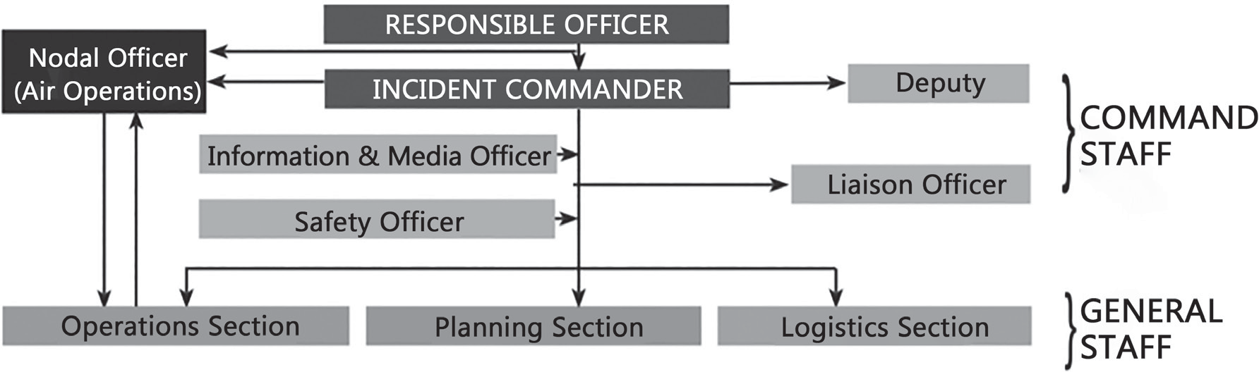
Figure: Incident Response System (IRS) Organization Model The Dahsala or Zabti System
Incident Response Team (IRT)
• The ROs of the State and Districts will constitute IRTs from among officers at the State and District level respectively.
• The members of IRTs will be properly trained and sensitized regarding their roles during the pre-disaster phase itself. Selection of different section chiefs will be guided by the nature and type of disaster.
• The headquarters IRT will provide continuous support to the on-scene IRT(s) and if required join them or take over response on the directions of the RO.
Odisha Model of Disaster Management
Odisha Model of Disaster Management
• In October 1999, a super cyclone of massive proportions ripped through the entire Odisha coast snuffing away over 10,000 lives while rendering millions homeless.
• In 2013, Cyclone Phailin wreaked havoc in the state affecting over 1.1 million people and causing damages worth ₹4,240 crore.
However, a little more than two years ago, on May 3, 2019, Odisha was hit by cyclone Fani with a sustained windspeed of 180-190 km per hour that claimed 64 lives and caused damages worth over ₹24,176 crore. Termed “rarest of the rare” summer cyclone, Fani could have wreaked huge casualties across the districts of Puri and Khurda but for the massive pre-disaster planning undertaken by the state government. As the state readies for cyclone Yaas, scheduled to make landfall on May 26, 2021, its expertise and resilience in dealing with disasters have come in for praise.
Home to over 4.6 crore people, Odisha, along the Bay of Bengal, often acts as a magnet for all kinds of natural disasters starting from floods, cyclones to droughts. Hence, it has often been referred to as the ‘disaster capital’ of the country.
Odisha took a conscious decision and gradually built upon its capacity, particularly at the community level. It has successfully started
Community-level warning network
Built network of multi-purpose cyclone and flood shelters on high stilts under national cyclone risk mitigation project to avoid sea surges and persistent water-logging
Built an Early Warning Dissemination System with last-mile connectivity.
Timely evacuation
Maintenance Committees where youth have been involved and trained for search and rescue, first aid medical attention, and for providing cyclone warnings
Decentralized Governance, with district, block and village level disaster management planning committees have been set up.
Odisha Disaster Rapid Action Force (ODRAF) that comprises highly trained personnel with equipped with sophisticated equipments required for disaster management, including road clearing equipment, branch cutter, tree pruner, concrete cutter, RCC cutter, boat, inflatable tower light, generator, forklift, hydraulic rescue kit, collapse structure search & rescue (CSSR) kit, medical first responder (MFR) kit, ambulance, manikin, high discharge submersible pump, flexi tent, flexi water tank, mountaineering equipment, commando searchlight, diving equipment set, breathing apparatus with a gas mask and chemical cartridge, the force is well-trained in tackling floods, building collapses,cyclones, biological and nuclear disasters.
Conversion of kuccha houses into pucca ones under state-specific schemes like Biju Pucca Ghar Yojana, Mo Kudia or central schemes like Pradhan Mantri Grameen Awas Yojana.
Panchayats stock basic rations like rice, pulses, jaggery and kerosene.
Zero Casualty remains our goal.
However, Odisha has fallen short in its post-disaster response as well as preventing large scale damages to its infrastructure like power lines, telecom lines, internet, housing and primary sector like agriculture, fisheries and animal husbandry.
• Last 5 cyclones in Odisha
• October 2013: Extremely severe cyclonic storm Phailin crossed Odisha coast at Gopalpur, accompanied by a storm surge of 5 feet and heavy rainfall. Death toll- 59
• October 2014: Extremely severe cyclonic storm Hudhud made landfall near Vishakhapatnam and then passed through Odisha. Death toll- 0
• October 2018: Very severe cyclonic storm Titli made landfall at Srikakulam in Andhra Pradesh but changed course to wreak much damage in interior districts of Odisha. Death toll-77
• May 2019: Very severe cyclonic storm Fani made
landfall at Puri. Death toll-89
• May 2020: Severe cyclonic storm Amphan made landfall at Sundarbans. Death toll-3
• Recently the two coastal villages in Odisha, Venkatraipur in Ganjam district and Noliasahi in Jagatsingpur district earned the recognition of being ‘Tsunami Ready’ from the UNESCO-Intergovernmental Oceanographic Commission, making India the first country in the Indian Ocean Region to establish such high levels of disaster preparedness at the community level.
• Community based disaster risk reduction is at the very heart of Odisha’s approach towards disaster management.
As India is increasingly trying to develop a system of community-based disaster risk reduction and management in the country, it is important to understand how Odisha has tackled recent disasters with the community at the forefront. The distinguishing features of Odisha’s way of disaster management which has earned it global appreciation therefore need to be identified