Coastal Region
Coastal Region
The Indian subcontinent is among the most cyclone-prone
regions globally. With an extensive coastline stretching 7,500 km, it is vulnerable to nearly 10% of the world's tropical cyclones. Most of these cyclones originate over the Bay of Bengal and make landfall along India's eastern coast. On average, five to six tropical cyclones develop annually, with two to three intensifying into severe storms.
The Bay of Bengal experiences more cyclones compared to the Arabian Sea, with an approximate ratio of 4:1. Both coastlines are affected by tropical cyclones—the east coast by the Bay of Bengal and the west coast by the Arabian Sea. These cyclones typically occur during the pre-monsoon months of May to June and the post- monsoon period from October to November.
Vulnerability Profile of India
Vulnerability
Vulnerability refers to the degree to which a community, infrastructure, service, or geographical region is at risk of damage or disruption due to a specific hazard. This susceptibility is influenced by factors such as the area's characteristics, structural integrity, and proximity to hazardous terrain or disaster-prone zones.
The United Nations International Strategy for Disaster Reduction (UN ISDR) defines vulnerability as the set of physical, social, economic and environmental conditions or processes that heighten a community’s exposure to the adverse effects of hazards.
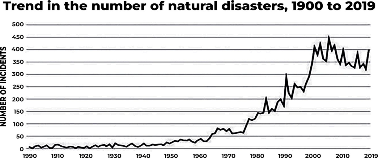
Vulnerability Profile of India
Vulnerability assessment is, therefore, a complex data- gathering process aimed at identifying the "elements at risk," which include social, economic, natural, and physical factors. This process is always site-specific, focusing on the distinct characteristics of a given location. Effective assessment relies on local expertise and knowledge to account for the unique conditions of each community.

Map: Disaster Vulnerability Map of India
• India, owing to its physiographic diversity and climatic conditions, ranks among the most disaster-prone regions in the world. The country faces varying degrees of vulnerability to multiple natural hazards:
• Earthquakes: Nearly 59% of India's landmass is susceptible to earthquakes ranging from moderate to severe intensity, with 55% of the total area falling under seismic zones III and above.
• Floods and River Erosion: Approximately 12% of the land area, covering over 40 million hectares, is vulnerable to flooding and river erosion.
• Coastal Hazards: Of India's 7,516 km-long coastline, nearly 5,700 km is prone to cyclones and tsunamis, particularly along the eastern coast and Gujarat.
• Droughts: Around 68% of cultivable land is exposed to
drought conditions.
• Landslides and Avalanches: Hilly regions, particularly the Sub-Himalayan sector and Western Ghats, are at risk of landslides and avalanches.
• CBRN and Man-Made Disasters: India is also vulnerable to chemical, biological, radiological, and nuclear (CBRN) emergencies, alongside other human-induced disasters.
• Compounding Disaster Risks: Disaster risks in India are
exacerbated by multiple factors, including:
• Demographicchanges and socio-economic conditions
• Unplanned urbanization
• Development in high-risk zones
• Environmental degradation
• Climate change
• Geological hazards
• Epidemics and pandemics
• These factors collectively pose a significant threat to India’s economy, population, and sustainable development.
• Contributing Factors to Disaster Vulnerability: India's susceptibility to disasters arises from both natural and human-induced factors, including:
• Adverse geo-climatic conditions
• Topographical variations
• Environmental degradation
• Population growth
• Urbanization
• Industrialization
• Unscientific development practices
• Geological Divisions of India: India is broadly categorized into three major geological regions:
• 1. The Himalayas (Extra-Peninsular region)
• 2. The Indo-Gangetic Plains
• 3. The Peninsular region
Aspects of Vulnerability
• Aspects of Vulnerability
Vulnerability encompasses multiple dimensions influenced by physical, social, economic, and environmental factors.
Examples of vulnerability include poorly designed and constructed buildings, insufficient protection of assets, lack of public awareness and information, inadequate official recognition of risks and preparedness strategies, and failure to implement effective environmental management practices.
The level of vulnerability can vary within a community and change over time. This concept defines vulnerability as an inherent characteristic of a specific element such as a community, system, or asset separate from its exposure. However, in everyday usage, the term is often applied more broadly to include exposure as well.
Physical Vulnerability
Physical vulnerability refers to the geographical location of individuals, their closeness to hazardous areas, and the safety measures in place to mitigate potential impacts. For instance, people are at risk of flooding primarily because they reside in flood-prone regions.
Additionally, physical vulnerability is linked to the structural resilience of buildings and infrastructure, determining their ability to withstand external forces during a hazardous event.
Furthermore, understanding physical vulnerability requires considering broader social and political factors, including political conflicts, class struggles, disparities in power, and social marginalization. Addressing these aspects is essential for developing a comprehensive strategy to reduce vulnerability.
Socio-economic Vulnerability
The extent to which a population is impacted by a disaster is not solely determined by physical aspects of vulnerability but is also influenced by broader social and economic conditions. These factors shape human activities within a society and contribute to varying levels of risk.
Disasters expose the unequal capacities of individuals and communities, highlighting differences in vulnerability and losses. This concept, commonly discussed in disaster studies, is referred to as socio-economic vulnerability.
• Social vulnerability is a complex interplay of various characteristics, including:
• Initial well-being: Factors such as nutritional status, physical and mental health, and overall morale.
Livelihood and resilience: Patterns of assets and capital, income sources, and available economic opportunities.
Self-protection: The extent of safety measures individuals take, including their ability and willingness to construct secure housing and settle in safe locations.
Social protection: Hazard preparedness initiatives provided by society, such as building codes, disaster mitigation strategies, emergency shelters, and preparedness programs.
Social and political networks and institutions: The role of social connections and institutional frameworks in promoting hazard preparedness, safeguarding rights, and ensuring people can voice their needs and access necessary resources.
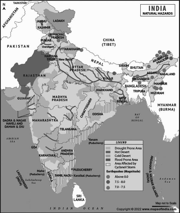
Vulnerability Assessment and Analysis
Vulnerability Assessment and Analysis
Once knowledge is acquired about existing threats, their likely severity, the areas at risk, and the extent of potential damage, it becomes essential to formulate effective policies for mitigation. This process is known as Vulnerability Assessment, which is defined as:
• "The evaluation of vulnerabilities across various sectors exposed to natural hazards identified through hazard analysis. These sectors include social, economic, livelihoods, physical assets, agriculture, political, and administrative domains." (DMTP, 1994).
• Vulnerability refers to the likelihood of a community, infrastructure, service, or region being damaged or disrupted by a specific hazard. People face direct threats to their lives and health due to the destructive impacts of disasters. Additionally, their incomes and livelihoods are at risk due to the loss of essential assets, including buildings, crops, livestock, and equipment.
• Even if physical losses are prevented, the impact on livelihoods can persist for a long time, and previous living conditions may never be fully restored.
• For instance, a fire in an informal market may not cause fatalities but can destroy goods, severely affecting the livelihoods of traders. Therefore, vulnerability assessment aims not only to identify those immediately impacted but also to determine who is most or least capable of recovery.
• The primary goal of vulnerability assessment is to identify the most vulnerable individuals or groups and understand the reasons behind their heightened risk.
• Vulnerability analysis aligns with the political economy approach to disaster management, emphasizing the state's role in leading structural mitigation efforts to prevent hazards. Governments must also create an environment conducive to non-structural mitigation measures, such as strengthening social capital to encourage community self-reliance.
• Both Tokyo, Japan, and Managua, Nicaragua, are prone to earthquakes. However, people in Tokyo face significantly lower risks of injury due to strict enforcement of building codes, zoning laws, earthquake preparedness training, and communication systems. In contrast, many people in Managua continue to live in structurally weak mud houses on unstable hillsides, making them highly vulnerable.
• Landslides and floods are often linked to rapid and uncontrolled urbanization, forcing low-income families to settle in hazardous areas such as steep hillsides, ravines, or flood-prone riverbanks.
• Famines can be triggered by a lack of purchasing power, often due to rural unemployment or a sudden influx of refugees from a neighboring conflict-affected country.
•
High casualties from earthquakes typically result from the collapse of poorly constructed, low-cost housing.
• Cyclones and tsunamis can become more destructive when human activities degrade natural protective barriers, such as coral reefs, windbreaks, and mangrove forests.
• The most disaster-prone countries are often those experiencing rapid environmental degradation. Nations facing deforestation, soil erosion, over cultivation, and overgrazing tend to suffer the worst consequences during disasters.
• Natural hazards act as trigger mechanisms that, when combined with vulnerable human conditions, lead to disasters.
Process of Vulnerability Analysis
Process of Vulnerability Analysis
Each type of hazard poses a unique set of risks to different "elements." Disaster mitigation efforts primarily focus on reducing vulnerability, which requires development planners to identify and analyze the elements most at risk from key hazards. Vulnerability assessment typically follows a two- step process:
Inventory of Elements at Risk: Once potential hazards in a specific area are identified, it is crucial to determine what could be affected. This requires gathering baseline data on the following:
Population: Age, gender, and health conditions
Livelihoods: Types of occupations and their locations
Local economies
Agriculture and fisheries
Buildings and infrastructure
Cultural assets: Including libraries, museums, and historical landmarks
Local institutions
Assessing the Vulnerability of At-Risk Elements: After compiling an inventory, the next step is to evaluate how these elements would be impacted by hazards to determine the level of risk. While quantifying existing elements in a particular area is relatively straightforward, assessing their potential response to a hazard event is more complex.
• It is essential to recognize that both tangible and intangible aspects of vulnerability are significant. Apart from measurable factors, it is crucial to consider socio- economic vulnerabilities, individual and community coping mechanisms, and support systems that enable some individuals or groups to recover more effectively from disasters.
| PRINCIPAL VULNERABLE ELEMENTS | ||
| Tangible | Intangible | |
| Floods | Everything located in flood plains or tsunami areas. Crops, livestock, machinery, equipment, infrastructure, weak buildings | Social cohesion, community structures cohesion, cultural artifacts |
| Earthquakes | Weak buildings and occupants. Machinery and their equipment, infrastructure. Livestock. Contents of weak buildings | Social cohesion, community structures cohesion, cultural artifacts |
| Landslides | Anything located on or at base of steep slopes or cliff tops, roads and infrastructure, buildings on shallow foundations | Social cohesion, community structures cohesion, cultural artifacts |
| Strong winds | Lightweight buildings and roofs. Fences, trees, signs; fishing boats and coastal industries, Crops and livestock. | Community structures, social cohesion, cultural artifacts |
| Technological disasters | Lives and health of those involved or near the vicinity. Building, equipment, infrastructure, crops and livestock | Destruction of the environment. Cultural losses. Possible population disruption. |
The most challenging vulnerabilities to address stem from exclusion from social, economic, and political systems, as these deeply influence people's capacities and susceptibility to risks. Since these vulnerabilities are embedded in historical and cultural contexts, they often manifest in forms of discrimination based on race, gender, religion, ethnicity, social class, or age. Such fundamental vulnerabilities restrict access to resources, opportunities, services, and information, ultimately
Vulnerability Profile of India
Vulnerability Profile of India
depriving individuals of control and decision-making power over their lives.
Vulnerability assessment is, therefore, a complex data- gathering process aimed at identifying the "elements at risk," which include social, economic, natural, and physical factors. This process is always site-specific, focusing on the distinct characteristics of a given location. Effective assessment relies on local expertise and knowledge to account for the unique conditions of each community.

Map: Disaster Vulnerability Map of India
• India, owing to its physiographic diversity and climatic conditions, ranks among the most disaster-prone regions in the world. The country faces varying degrees of vulnerability to multiple natural hazards:
• Earthquakes: Nearly 59% of India's landmass is susceptible to earthquakes ranging from moderate to severe intensity, with 55% of the total area falling under seismic zones III and above.
• Floods and River Erosion: Approximately 12% of the land area, covering over 40 million hectares, is vulnerable to flooding and river erosion.
• Coastal Hazards: Of India's 7,516 km-long coastline, nearly 5,700 km is prone to cyclones and tsunamis, particularly along the eastern coast and Gujarat.
• Droughts: Around 68% of cultivable land is exposed to
drought conditions.
• Landslides and Avalanches: Hilly regions, particularly the Sub-Himalayan sector and Western Ghats, are at risk of landslides and avalanches.
• CBRN and Man-Made Disasters: India is also vulnerable to chemical, biological, radiological, and nuclear (CBRN) emergencies, alongside other human-induced disasters.
• Compounding Disaster Risks: Disaster risks in India are
exacerbated by multiple factors, including:
• Demographicchanges and socio-economic conditions
• Unplanned urbanization
• Development in high-risk zones
• Environmental degradation
• Climate change
• Geological hazards
• Epidemics and pandemics
• These factors collectively pose a significant threat to India’s economy, population, and sustainable development.
• Contributing Factors to Disaster Vulnerability: India's susceptibility to disasters arises from both natural and human-induced factors, including:
• Adverse geo-climatic conditions
• Topographical variations
• Environmental degradation
• Population growth
• Urbanization
• Industrialization
• Unscientific development practices
• Geological Divisions of India: India is broadly categorized into three major geological regions:
• 1. The Himalayas (Extra-Peninsular region)
• 2. The Indo-Gangetic Plains
• 3. The Peninsular region
The Himalayan Region
The Himalayan Region
Classification and Disaster Vulnerability of the Himalayan Region
The Himalayas can be categorized using two distinct methods:
• Method 1 (West to East Division):
• Punjab Himalaya – The stretch between the Indus and Sutlej Rivers.
• Kumaon Himalaya – Extending from Sutlej to Kali Rivers.
• Nepal Himalaya – Located between the Kali and Tista Rivers.
• Assam Himalaya – Spanning the area from Tista to Brahmaputra Rivers.
• Method 2 (Broad Regional Classification):
• Nepal Himalaya – Forming the Central Himalayan region.
• Western Himalayas – Covering the mountainous
terrain to the west.
• Eastern Himalayas – Encompassing the eastern range. Each of these regions is susceptible to various natural disasters.
• Monsoon precipitation, combined with steep slopes, faulted and weathered rock formations, increases the region’s vulnerability to landslides and flash floods.
• Landslides occur frequently, with major incidents including:
• Malpa landslide (1998) Okhimath landslide (1998) Uttarkashi disasters (2003 & 2012) Uttarakhand flash floods (2013) Noney landslide in Manipur (2022). The Himalayan region falls under Seismic Zones IV
and V, making it highly prone to earthquakes.
• Though the Himalayas are the most earthquake-prone, no part of India falls in Seismic Zone I, meaning earthquake risks are prevalent across the country.
• Significant earthquakes in recent history include:
• Uttarkashi earthquake (1991) Killari earthquake (1993) Koyna earthquake (1997) Chamoli earthquake (1999) Bhuj earthquake (2001) Jammu & Kashmir earthquake (2005) Sikkim earthquake (2011)
• High-Altitude Areas (Above 3,500 meters):
• Sparse vegetation and predominantly snow-covered
throughout the year.
• Unpredictable weather, reduced oxygen levels, and strong winds.
• Presence of glaciers, moraines, and cold-water lakes.
• Prone to avalanches, crevasses, and heavy snowfall.
• Snowmelt during summer increases water inflow in lakes and rivers, heightening flood risk.
• Hilly Areas (Below 3,500 feet):
• More susceptible to heavy rainfall, cloudbursts, flash floods, landslides, and mudflows.
• Key natural hazards in this region include:
• Earthquakes
• Landslides
• Forest fires
• Soil erosion
• Snow avalanches
• Flash floods
These factors collectively illustrate the Himalayan region’s high vulnerability to natural disasters.
The Gangetic Plain
The Gangetic Plain
The Indo-Gangetic Plain, characterized by its dense population and extensive drainage by Himalayan rivers, is highly susceptible to both floods and droughts. Approximately 75% of the total annual rainfall occurs within the short monsoon period between June and September.
The major river systems originating from the Himalayas carry vast amounts of sediment, leading to river channel siltation. This phenomenon significantly contributes to frequent flooding, particularly in the plains of Uttar Pradesh and Bihar.
Arid and Semi Region
Arid and Semi-Arid Regions
Arid and semi-arid regions are defined by a climate with minimal or inadequate rainfall, making it insufficient to support agricultural production. In India, 37% of the total land area falls within these arid and semi-arid zones.
Rainfall in these regions is erratic, often occurring in intense but short-lived storms, leading to high surface runoff rather than replenishing groundwater resources. The vegetation cover is sparse, and moisture availability remains low for most of the year.
Agricultural activities in these areas are confined to limited but fertile lands, while large livestock populations depend on native vegetation for survival. Irrigation, either through surface water or groundwater sources, is essential for cultivation in such regions. The rainfall distribution across the country varies, ranging from humid conditions in the northeast (approximately 180 rainy days per year) to arid conditions in the Thar Desert of Rajasthan (receiving rain on only 20 days per year).
The western states, including Rajasthan, Gujarat, and parts of Maharashtra, frequently experience drought conditions.
If the monsoon weakens, drought conditions can spread to other regions as well. Additionally, changes in atmospheric pressure over oceans can lead to cyclones affecting coastal areas. The ongoing geo-tectonic movements on the ocean floor further make coastal regions susceptible to tsunamis.
Deccan Plateau
Deccan Plateau
The Deccan Plateau is a peninsular highland situated in central India, covering the inland regions of Andhra
Pradesh, Maharashtra, and Karnataka.
This plateau is bounded by the Western Ghats to the west, the Nilgiri Hills in the south, the Eastern Ghats to the east, and the Aravalli and Chota Nagpur Hills towards the north.
Despite the presence of several major rivers such as the Narmada, Tapi, Mahanadi, Godavari, Krishna, and Cauvery, the Deccan Plateau experiences severe water scarcity. These rivers generally have well-defined and stable courses.
Most of these rivers carry floodwaters efficiently within their natural banks, except in the delta regions, where the risk of flooding is higher. However, embankments along the lower reaches of major rivers on the East Coast have significantly reduced the occurrence of floods in these areas
Western and Eastern Ghats
Western and Eastern Ghats
The Western and Eastern Ghats, which run parallel to the coastline, experience challenges such as landslides and droughts, particularly in the rain shadow regions. The Western Ghats stretch from the Satpura Range in the north, passing through Maharashtra, Goa, Karnataka, Kerala, and Tamil Nadu.
Recognized as one of the 33 ecologically sensitive zones globally, the Western Ghats and Nilgiri Hills, despite being geologically stable, are susceptible to landslides during the monsoon season.
Environmental concerns such as population pressure, illegal mining, quarrying, and deforestation have increased the vulnerability of both the Western and Eastern Ghats to natural disasters.
Unlike the Western Ghats, the Eastern Ghats do not form a continuous range of escarpments, and cliffs are largely absent. Instead, the range is fragmented into separate circumdenudation hills.
The only prominent mountainous region in the Eastern Ghats is in Odisha. Rivers such as the Mahanadi, Godavari, and Krishna have carved gaps through the range, disrupting its continuity. Additionally, the Eastern Ghats are positioned farther from the coastline compared to the Western Ghats.
Running parallel to the Bay of Bengal, the Eastern Ghats have the Deccan Plateau to their west, lying between them and the Western Ghats.
The coastal plains, including the Coromandel Coast, stretch between the Eastern Ghats and the Bay of Bengal. Unlike the Western Ghats, the Eastern Ghats are lower in elevation and are characterized by geological features such as thrusts and strike-slip faults