Introduction
INTRODUCTION
Space technology utilizes scientific knowledge and engineering principles to explore and utilize outer space, enabling human activities like satellite communications, weather forecasting, navigation and Earth observation, with significant advancements.
Space Technology has become a crucial aspect of modern societies, enabling the efficient functioning of societies and economic development. It encompasses various technologies such as satellites, space stations, ground stations, monitoring centers, analytics, AI, and software.
Satellites provide cost-effective ways to build capacity for earth observation, communication, and navigation services, even in remote locations. They are essential for data-driven decisions for businesses and governments. Satellites can enable high-speed connectivity for underserved and non- economically viable geographies, aiding in action plans for intelligent agriculture, land and water resource management, urban and rural infrastructure development, weather and climate monitoring, and environmental protection.
The global space industry was valued at USD 360 Bn. in 2018 and is expected to grow to USD 558 Bn. by 2026 and USD 1 Trillion by 2040. India currently occupies a small 2% or USD 7 Bn. of this market value, despite being one of the leading space agencies globally. This is due to ISRO’s in-house value addition activities and the private industry’s limited contribution to the Indian space sector, resulting in a lack of end-to-end capabilities in SpaceTech compared to other global leaders.
Background
Early in life, we become aware of the attraction of all material objects towards the earth. Galileo, an Italian physicist, recognized that all bodies are accelerated towards the earth with constant acceleration. Observation of stars, planets, and their motion has been a subject of attention since the earliest times. The earliest recorded model for planetary motions proposed by Ptolemy was a ‘geocentric’ model, where all celestial objects, stars, the sun, and planets revolve around the earth. However, a more elegant model, the ‘heliocentric’ model, was already mentioned by Aryabhatta in his treatise.
A thousand years later, Polish monk Nicolas Copernicus proposed a definitive model in which planets moved in circles around a fixed central sun. Copernicus’ theory was discredited by the church, but Galileo was among its
supporters. Tycho Brahe, a Danish nobleman, spent his lifetime recording observations of planets with the naked eye. His compiled data were later analyzed by his assistant Johannes Kepler, who extracted three elegant laws known as Kepler’s laws. These laws were known to Newton, who used them to propose his universal law of gravitation. These are:
Kepler’s First Law - The Law of Orbits: All planets move in elliptical orbits with the Sun at one of the two foci of the ellipse. The point at which the planet is closest to the Sun is known as perihelion, and the point at which the planet is farthest from the Sun is known as aphelion.
Kepler’s Second Law - The Law of Equal Areas: A line that connects a planet to the Sun sweeps out equal areas in equal intervals of time. This means that a planet moves faster when it is closer to the Sun and slower when it is farther away.
Kepler’s Third Law - The Law of Periods: The square of the orbital period of a planet is proportional to the cube of the semi-major axis of its orbit. This means that the farther a planet is from the Sun, the longer it takes to complete one orbit around the Sun.
Universal Law of Gravitation
Legend has it that observing an apple falling from a tree, Newton was inspired to arrive at a universal law of gravitation that led to an explanation of terrestrial gravitation as well as of Kepler’s laws. Newton’s reasoning was that the moon revolving in an orbit of radius Rm was subject to a centripetal acceleration due to earth’s gravity of magnitude. The gravitational force of the sun on the planet is directed towards the sun.

where m1 and m2 are respectively the masses of the planet and the sun, R is the distance between them and G is the universal constant of gravitation. This clearly shows that the force due to earth’s gravity decreases with distance.
Universal Law of Gravitation: Every body in the universe attracts every other body with a force which is directly proportional to the product of their masses and inversely proportional to the square of the distance between them. The quotation is essentially from Newton’s famous treatise called ‘Mathematical Principles of Natural Philosophy’ (Principia for short).
The Electromagnetic Spectrum
The Electromagnetic Spectrum
The range of all EM radiation types is known as the electromagnetic (EM) spectrum. Electromagnetic radiation includes radio waves from a radio station and visible light from lamps in your home. Radiation is defined as energy that flows and spreads out along its path. The electromagnetic spectrum also consists of various forms of radiation, such as microwaves, X-rays, gamma rays, infrared light and ultraviolet light.
The picture below depicts where you might encounter each section of the electromagnetic spectrum in your daily life.
• Radio: Your radio picks up the radio waves that stations generate and plays your favourite songs. Stars and gases also emit radio waves into space.
• Microwave: Not only does microwave radiation quickly cook popcorn, but it is also utilized by astronomers to understand the composition of neighbouring galaxies.
• Infrared: The infrared light that is released by our skin and hot objects is detected by night vision goggles. Infrared radiation from space is used to map the dust that exists between stars.
• Visible: Visible light is detected by our eyes. Visible light is emitted by stars, fireflies, and light bulbs.
• Ultraviolet: The Sun emits ultraviolet light, which causes skin to burn and turn tan. Additionally, “hot” objects in space release UV light.
• X-ray: X-rays are used by dentists to take pictures of your teeth and by airport security to look through bags. In the universe, hot gasses also release X-rays.
•
Gamma ray: Utilizing gamma-ray imaging, doctors look into your body. The universe is the largest known source of gamma radiation.
Is a radio wave the same as a gamma ray?
Are gamma-rays and radio waves entirely different types of physical objects? They are not essentially different, even if they are created using different methods and detected in other ways. Electromagnetic radiation includes visible light, gamma rays, radio waves, and all other forms of
electromagnetic radiation.
A stream of massless particles called photons, which move at the speed of light in a wave-like pattern, can be used to represent electromagnetic radiation. There is a specific quantity of energy in each photon. The energy contained in photons is what distinguishes the various forms of radiation. Low-energy photons are found in radio waves; microwave photons are slightly more energetic than radio waves; infrared photons are even more energetic than radio waves; finally, visible, ultraviolet, X-ray, and gamma-rays are the highest energy photons of all.
Measuring electromagnetic radiation
There are three ways to describe electromagnetic radiation: energy, wavelength and frequency. Hertz, or cycles per second, is used to measure frequency. Meters are used to measure wavelengths. Electron volts are used to measure energy. There is a precise mathematical relationship between each of these three values used to characterize electromagnetic radiation. However, what is the purpose of having three distinct sets of physical units for each description?
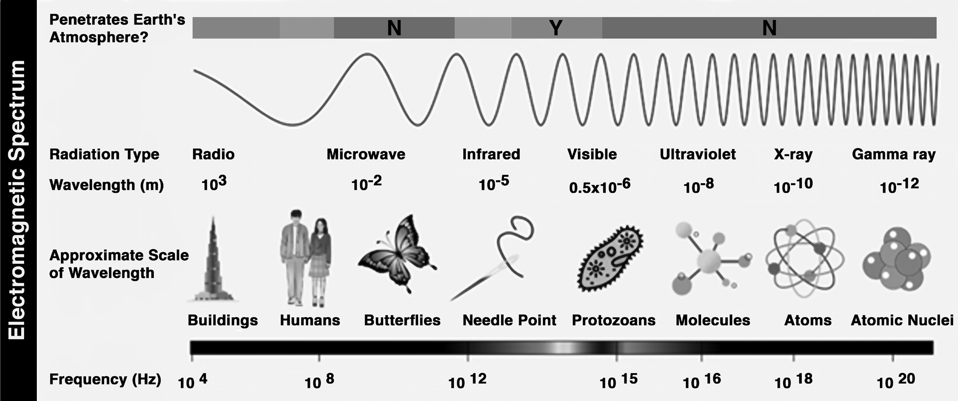
The basic explanation is that scientists prefer not to work with numbers that are larger or smaller than necessary. Saying or writing “two kilometres” is far simpler than “two thousand meters.” In general, scientists work with the simplest units available for the sort of electromagnetic radiation they study.
When studying radio waves, astronomers typically utilize frequencies or wavelengths. The majority of the radio portion
of the electromagnetic spectrum lies between approximately 1 cm and 1 km, or 30 GHz to 300 kHz in frequency. A fairly large portion of the electromagnetic spectrum is radio.
Infrared and optical astronomers commonly utilize wavelengths. Infrared astronomers use microns (millionths of a meter) for wavelengths, therefore their share of the electromagnetic spectrum ranges from 1 to 100 microns.
Optical astronomers work with both angstroms (0.00000001 cm, or 10-8 cm) and nanometres (0.0000001 cm, or 10-7 cm). Violet, blue, green, yellow, orange, and red light have wavelengths ranging from 400 to 700 nanometers. (Because this range is only a small portion of the overall electromagnetic spectrum, the light our eyes can perceive is only a small percentage of the EM radiation around us.) The wavelengths in the ultraviolet, X-ray, and gamma-ray.
Why do we put telescopes in orbit?
areas of the electromagnetic spectrum are extremely tiny. Astronomers studying these parts of the electromagnetic spectrum commonly refer to photons by their energies, which are measured in electron volts (eV), rather than their wavelengths. Ultraviolet radiation has an energy range of a few electron volts to around 100 eV. The energy of X-ray photons range from 100 to 100,000 eV (or 100 keV). Gamma- rays are all photons with energy greater than 100 keV.
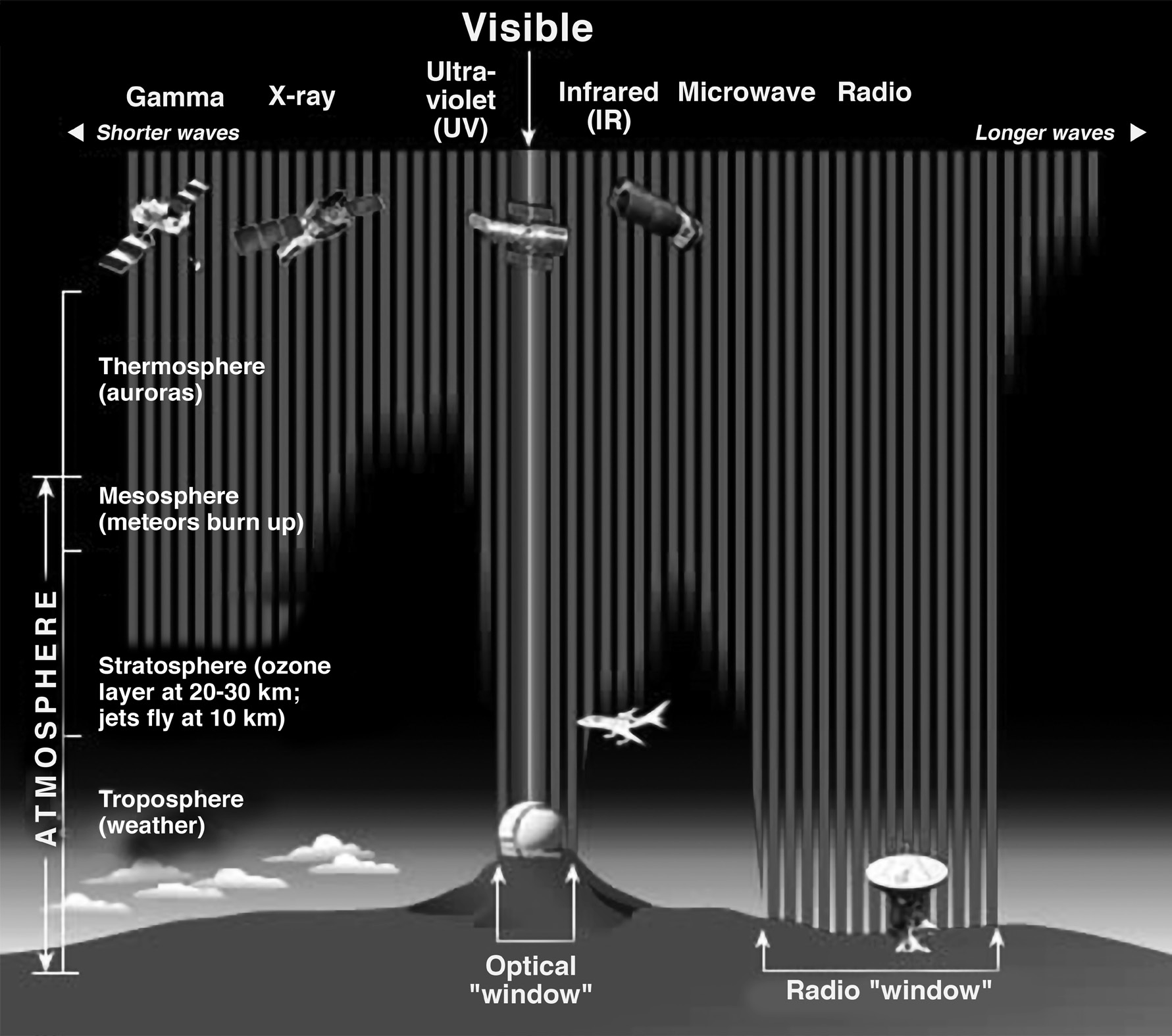
The Earth’s atmosphere prevents the majority of electromagnetic radiation from space from reaching the planet’s surface. This picture depicts how far different sections of the EM spectrum can penetrate the atmosphere before being absorbed. Only bits of radio and visible light reach the surface.
Most electromagnetic radiation from space does not reach the Earth’s surface. Radio frequencies, visible light, and some ultraviolet light reach sea level. Astronomers can observe some infrared wavelengths by mounting telescopes on mountaintops.
Balloon experiments can travel 35 kilometers above the earth and last for months. Rocket flights can transport
instruments all the way above the Earth’s atmosphere, but only for a few minutes before returning to Earth.
Satellite Frequency Bands
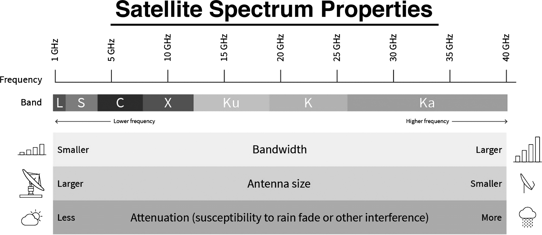
Because there are many different satellite frequency bands available for use, names for each have been established that make them simple to remember. Although higher frequency bands usually offer greater bandwidths, they are also more vulnerable to signal deterioration because of “rain fade,” which is the phenomenon where radio waves are absorbed by atmospheric precipitation such as rain, snow, or ice. The utilization, quantity and size of satellites have increased, and this has made congestion in the lower frequency bands a major problem. Research is underway on new technologies that could enable the usage of higher bands.
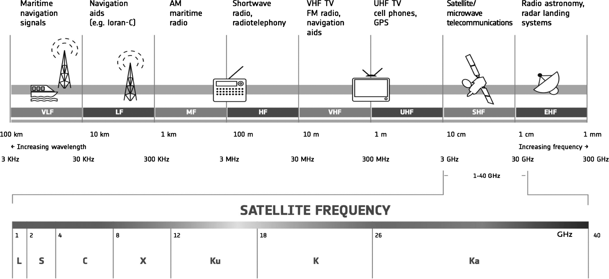
L-band (1–2 GHz)
• Global Positioning System (GPS) carriers; in addition, satellite mobile phones like Iridium; Inmarsat, which offers maritime, terrestrial, and aerial communications; World Space satellite radio.
S-band (2–4 GHz)
• Surface ship radar, weather radar, and a few communications satellites, including NASA’s for connecting to the International Space Station and Space Shuttle. The European Commission granted Inmarsat and Solaris mobile, a joint venture between Eutelsat and Astra, a 2 15 MHz section of the S-band in May 2009.
C-band (4–8 GHz)
It is primarily used for satellite communications, full- time satellite TV networks, and raw satellite feeds. It is commonly used in tropical rainy places because it is less vulnerable to rainfed than Ku band (the original Telstar satellite had a transponder operating in this band, which sent the first live transatlantic TV signal in 1962).
•
band (8–12 GHz)
Mainly utilized by the military. Radar applications include continuous-wave, pulsed, single-polarization, dual-polarisation, synthetic aperture radar, and phased arrays. X-band radar frequency sub-bands are utilized in civil, military, and government organizations for weather monitoring, air traffic control, maritime vessel traffic control, defense tracking, and vehicle speed detection for law enforcement purposes.
Ku-band (12–18 GHz)
• Used for satellite communication. In Europe, direct broadcast satellite services such as Astra use Ku-band downlink frequencies ranging from 10.7 GHz to 12.75 GHz.
Ka-band (26–40 GHz)
• Communication satellites use uplinks in the 27.5 GHz and 31 GHz bands, as well as military aircraft with high- resolution, close-range targeting radar.
The Big Bang Theory
The Big Bang Theory
The Big Bang Theory is the most widely accepted cosmological model for how the universe originated.
It asserts that 13.8 billion years ago, all of space was concentrated in a single point of extremely high density and warmth, from which the cosmos has expanded in all directions ever since.
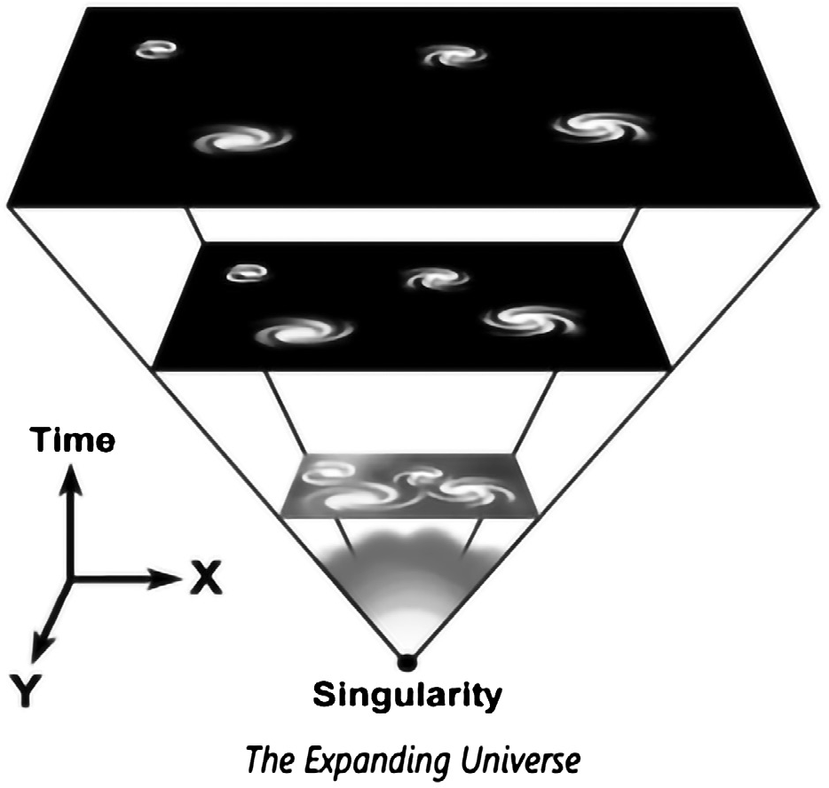
Accelerating Expansion of The Universe
Hubble’s law states that as the universe expands, the velocity of a galaxy traveling away from the observer increases over time.
It suggests that the universe will get increasingly colder as matter spreads throughout space.
The accelerated expansion of the cosmos is assumed to have begun since the universe reached its dark energy- dominated period, around 5 billion years ago.
Evidence for Big Bang Theory
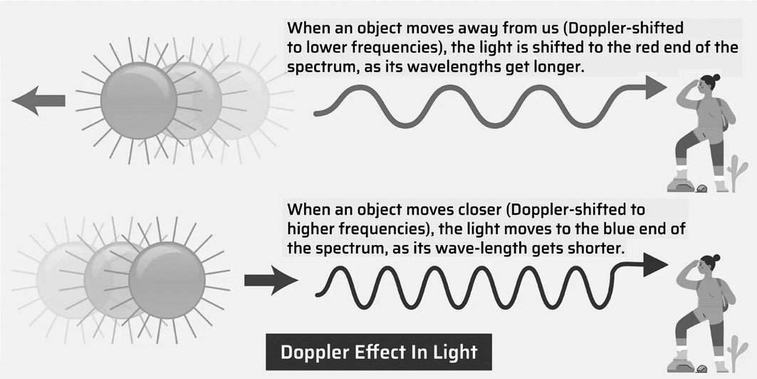
Cosmological redshift, as well as the discovery of cosmic microwave background radiation and gravitational waves, have all contributed to the Big Bang Theory’s validity.
Doppler-Shift or Redshift and Blueshift- Redshift and blueshift describe how light changes as objects in space
(such as stars or galaxies) approach or move away from us. Edwin Hubble, an American astronomer, was the first to describe the redshift phenomena (galactic redshift) and associate it with an expanding universe (galaxies drift apart).
Cosmic Microwave Background (CMB)- Using a typical optical telescope, the space between stars and galaxies is absolutely dark. However, a sensitive radio telescope can detect a faint background glow. This light is brightest in the microwave area of the radio spectrum, hence the name Cosmic Microwave Background (CMB). It is also known as relic radiation (thermal radiation left over from the “Big Bang”) and is essential to observational cosmology because it is the oldest light in the Universe, appearing in all directions. Its discovery is regarded as a watershed moment for the concept of “accelerating expansion of the universe” and the Big Bang Theory.
Gravitational Waves- Albert Einstein predicted the presence of gravitational waves in 1916 with his general theory of relativity. Gravitational waves are ‘ripples’ in spacetime created by some of the Universe’s most destructive and intense processes.
Massive speeding objects (such as neutron stars or black holes orbiting one other) would disrupt spacetime, causing ‘waves’ of warped space to radiate from the source (similar to waves moving away from a stone thrown into a pond). These ripples move at the speed of light through the Universe, conveying information about their beginnings.
Star Formation
Star Formation
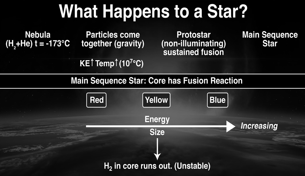
There are many stages involved in star formation:
A nebula is a cloud of gas (mostly hydrogen and helium) and dust in space. Nebulae are the birthplaces of stars.
Protostar: an early stage of a star creation where nuclear fusion is yet to commence.
T Tauri Star: a young star undergoing gravitational contraction, halfway between a protostar and a low-mass main sequence star.
Main Sequence Star: For example, the Sun is in full life, with nuclear fusion occurring at its core.
Small stars are classified as Red Giants and massive stars as Red Supergiants.
Planetary Nebula (small stars) and Supernova (big stars).
Importance of Supernova
When a star’s core runs out of hydrogen, it begins to die. The dying star swells into a red giant, which then begins to produce carbon by fusing helium atoms. More massive stars begin a new cycle of nuclear burning. These stages produce a wide spectrum of elements, including oxygen and iron. During a supernova, the star emits massive amounts of energy and neutrons, allowing metals heavier than iron, such as uranium and gold, to be formed. All of these elements are ejected into space during a supernova explosion, resulting in the formation of new stars. Thus, every element on Earth was generated by a supernova explosion!
Neutron stars
Neutron stars are mostly composed of neutrons and are formed during a supernova, which forces protons and electrons to combine to form a neutron star. A neutron star is extremely dense (a mass three times that of the Sun can be contained into a sphere only 20 kilometers across). If its mass increases, its gravity will be so intense that it will shrink even further, eventually becoming a black hole. Chandrasekhar Limit: The limit is the maximum mass at which a star nearing the end of its life cycle can become a white dwarf and collapse into a neutron star or black hole.
Black Holes
Black holes
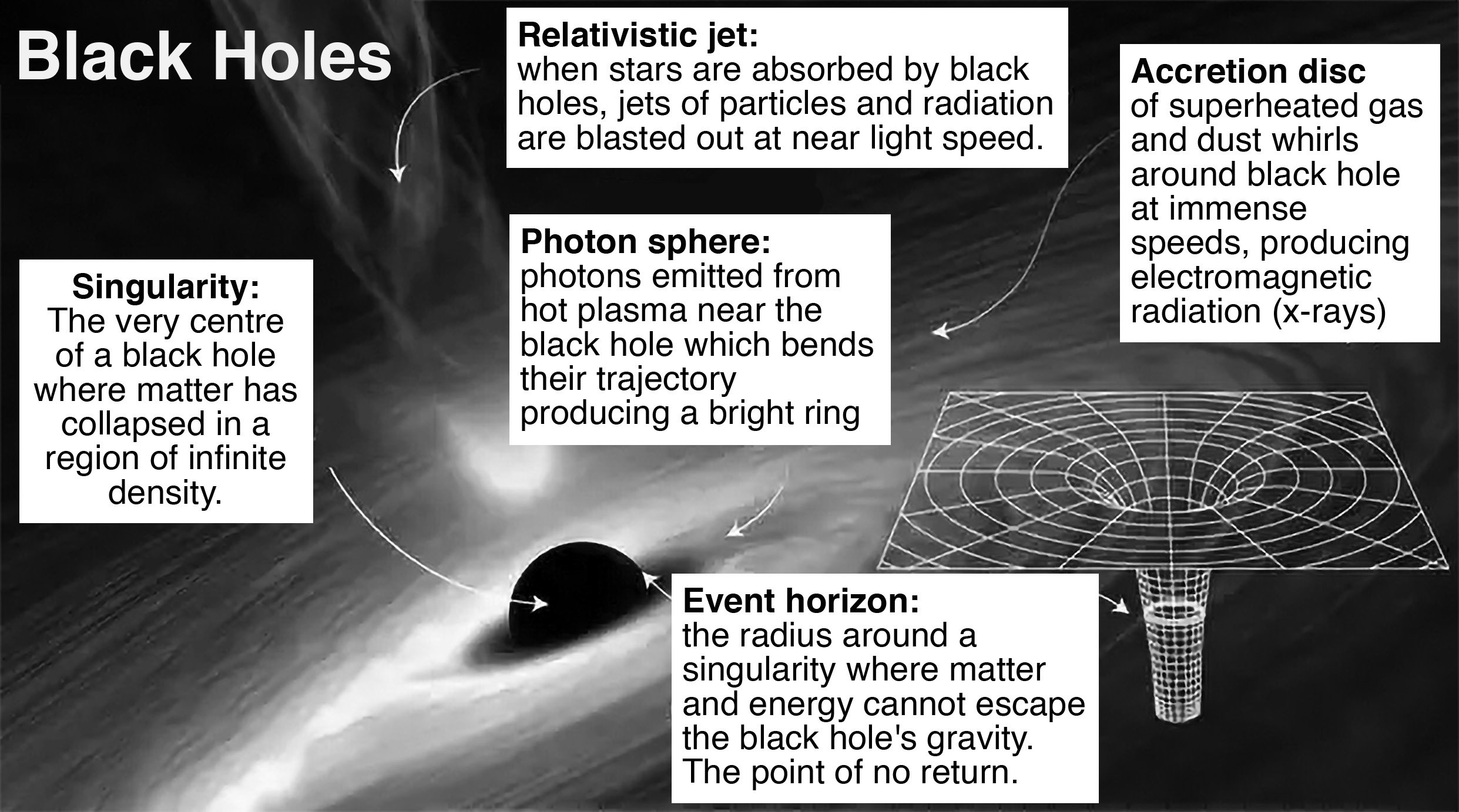
Black holes are thought to form as huge stars reach the end of their lives. The density of matter in a black hole cannot be quantified. The gravitational force is so strong that nothing can escape, including light. Black holes warp the space around them and can absorb nearby matter, including stars.
Parts of a Black Hole
Accretion disc: A black hole's major source of light is an accretion disk. Black holes grow by eating matter (a process known as accretion) and merging with other black holes. A stellar-mass black hole partnered with a star may draw gas from it, whereas a supermassive black hole does the same with stars that go too close.
• The gas forms a hot, brilliant, swiftly rotating disk. Matter gradually moves from the outside edge of the disk to its inner edge, where it enters the event horizon. Isolated black holes that have absorbed the matter around them lack an accretion disk and can be extremely difficult to locate and analyze.
• Singularity: According to general relativity, the center of a black hole contains a place where matter is crushed to infinite density. It is the ultimate destination for anything that falls within the event horizon.
• Astronomers now do not know whether the singularity is a physical structure or just mathematical. The prediction of a singularity may indicate the boundaries of relativity, where quantum factors not included in the theory play a major role in a more complete description of gravity.
•
Event horizon: This is why a black hole is black. The event horizon can be thought of as the surface of a black hole. Inside this boundary, the velocity required to escape the black hole exceeds the speed of light, which is the fastest that anything can go. So, anything that enters the event horizon is doomed to remain within it, including light. Because light cannot escape, black holes neither emit nor reflect it, and no outside observer can learn anything about what is going on inside. Astronomers can, however, view black holes using light released by surrounding stuff that has not yet reached the event horizon.
• Photon Sphere : A photon sphere is a sphere-shaped (or, more commonly, an oblate-spheroid-shaped) surface region around a black hole that indicates the distance at which photons can orbit the black hole; any circling photon will be found on it. For a non-rotating black hole, it is 3/2 the Schwarzschild radius away from the center. Within the photon sphere, no object can continue an orbit without accelerating (e.g., using a force): it will either fall into the event horizon or escape the black hole. This phenomenon is completely attributable to strong- field gravity, and in principle (i.e., if its equation of state would support such a density), a neutron star may be dense enough to have an external photon sphere.
Orbit
ORBIT
An orbit is the curved path that an object in space (such as a star, planet, moon, asteroid or spacecraft) takes around another object due to gravity. Gravity attracts objects of mass to nearby objects, causing them to orbit each other with enough momentum. In our Solar System, the Moon orbits Earth, and Earth orbits the Sun, but that does not mean the larger object remains completely still. Because of gravity, Earth is pulled slightly from its centre by the Moon (which is why tides form in our oceans) and our Sun is pulled slightly from its centre by Earth and other planets.
During the early creation of our Solar System, dust, gas, and ice travelled through space with speed and momentum, surrounding the Sun in a cloud. The Sun’s gravity attracted these particles into orbit, shaping the cloud into a ring around the Sun. These particles eventually settled and clumped together, growing larger like snowballs, forming planets, moons, and asteroids. This formation of planets, moons, and asteroids is why all planets have orbits around the Sun in the same direction and plane.
Satellites are launched by rockets into space, where gravity keeps them in their desired orbit. This process is similar to throwing a ball out of a window of a tall tower, where the initial speed is given by the throw, but gravity alone keeps the ball moving towards the ground once it is released. Satellites are placed hundreds or thousands of kilometres above Earth’s surface and then given a push by rocket engines to start their orbit. A powerful throw will cause the ground to curve away before the object reaches the ground, causing it to fall towards Earth indefinitely and circle the planet repeatedly.
In space, there is no air friction, so gravity allows the satellite to orbit around Earth with minimal assistance. This allows for technologies such as telecommunication, navigation, weather forecasting, and astronomy observations.
What shape is an orbit?
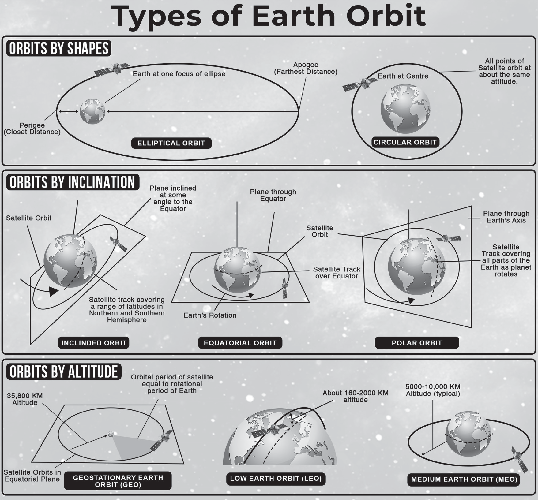
Orbits come in different shapes. All orbits are elliptical, which means they are an ellipse, similar to an oval. For the planets, the orbits are almost circular. The orbits of comets have a different shape. They look like a “squashed” circle. They look more like thin ellipses than circles.
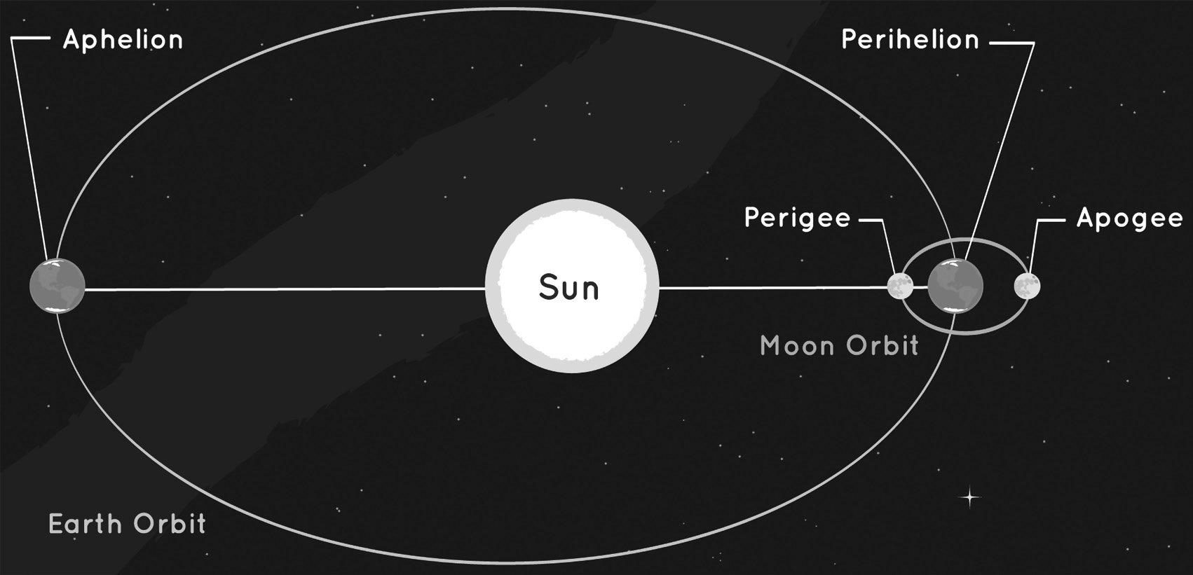
Satellites that orbit Earth, including the Moon, do not always stay the same distance from Earth. Sometimes they are closer, and at other times they are farther away. The closest point a satellite comes to Earth is called its perigee (peri + gee = close + earth). The farthest point is the apogee (apo + gee = far + earth). For planets, the point in their orbit closest to the Sun is perihelion (peri + Helion = close + Sun). The farthest point is called aphelion (ap + Helion = far + Sun). Earth reaches its aphelion during summer in the Northern Hemisphere. The time it takes a satellite to make one full orbit is called its orbital period. For example, Earth has an orbital period of one year
How Do Objects Stay in Orbit?
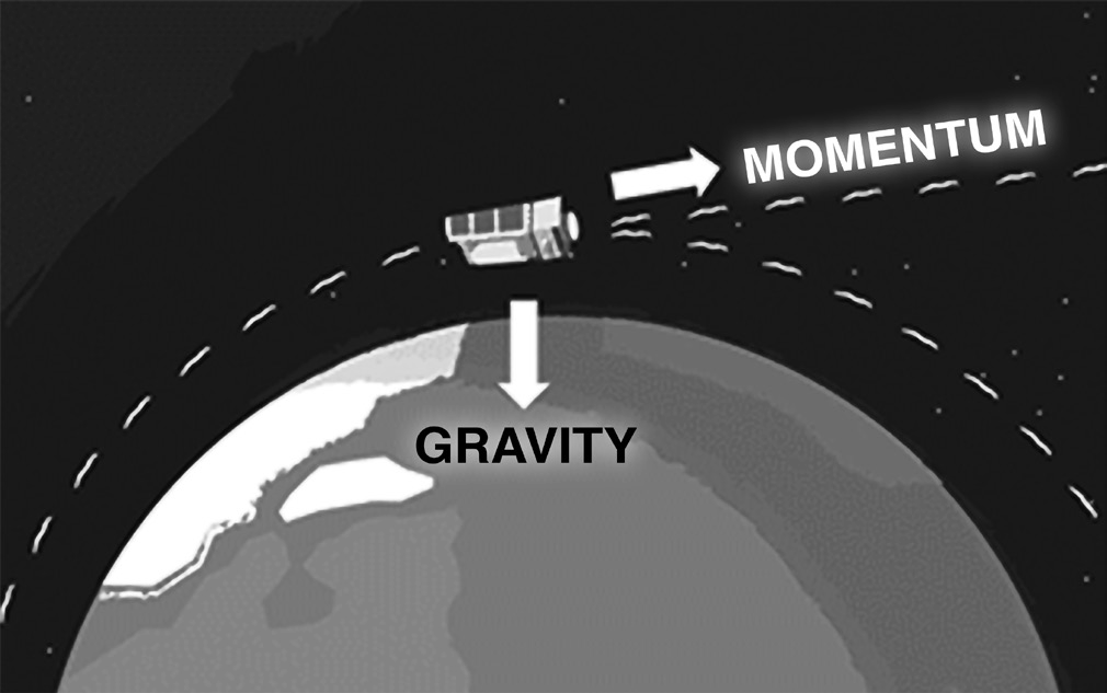
According to Newton’s first law of motion, unless a force is applied, an object in motion will continue to move. A satellite would travel in a straight path in the absence of gravity, but with the presence of gravity, it is drawn back towards Earth. The pull of gravity and the satellite’s momentum are always at odds with one another. An object’s momentum and gravity need to be balanced for it to enter an orbit. It will zoom by if its momentum is too high, and it will be pushed down and crash if its momentum is too low. The item always falls toward the planet when these forces are balanced.
Orbital Velocity
The velocity at which a body orbits another body is known as orbital velocity. An object is said to be in orbit when it revolves around the Earth in an uniform circular motion. The distance between the object and the earth’s center determines the orbit’s velocity. Artificial satellites are typically given this velocity in order to revolve around a specific planet.
The orbital velocity formula is given by, It is given by
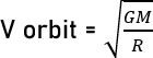
Where,
G = gravitational constant,
M = mass of the body at centre, R = radius of the orbit.
Orbital Velocity Formula is applied to calculate the orbital velocity of any planet if mass M and radius R are known.
Orbital Velocity is expressed in meter per second (m/s).
Satellites and Their Orbits
SATELLITES AND THEIR ORBITS
On the basis of distance from Earth
Low Earth Orbit (LEO)
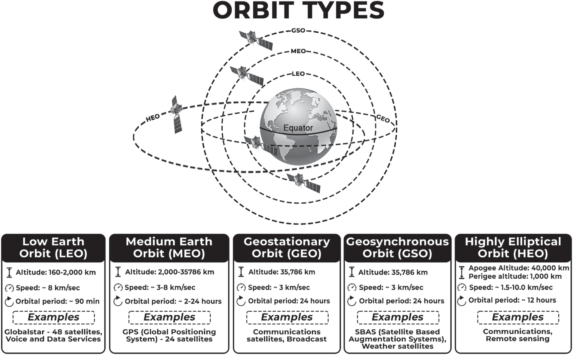
A low Earth orbit (LEO) is an orbit close to Earth’s surface, typically at an altitude of less than 2000 km but potentially as low as 160 km. This is significantly higher than most commercial aeroplanes, which typically fly at altitudes around 14 km. LEO satellites can be tilted, unlike those in GEO, which must always orbit along Earth’s equator. This allows for more available routes for satellites, making LEO a popular orbit for satellites.
LEO’s proximity to Earth makes it a popular orbit for satellite imaging and the International Space Station (ISS). It allows for higher resolution images and shorter travel distances for astronauts. Satellites in this orbit travel
at 7.8 km per second, taking 90 minutes to circle Earth, resulting in the ISS traveling around Earth 16 times a day. However, individual LEO satellites are less useful for tasks like telecommunication due to their fast movement across the sky and the effort required to track them from ground stations.
Medium Earth Orbit (MEO)
Medium Earth Orbit (MEO) occupies the area between LEO and HEO, orbiting at altitudes ranging from 2,000 km to 35,786 km.
While the boundary between MEO and LEO is arbitrary, the 35,786 km limit is carefully determined since it is the altitude above sea level that a satellite must reach to achieve a geosynchronous orbit. MEO satellites are typically larger than those in low Earth orbit, taking between two and twenty-four hours to complete a full orbit around the Earth.
With these slower trip periods, it is necessary that MEO satellites are physically larger to accommodate more powerful communications equipment and data capacity. Satellites in the MEO
GPS (Global Positioning System) or NAVSTAR
GLONASS (Global Navigation and satellite system of Russia)
GALILEO (European union)
BEIDOU-1 (China’s regional navigation in Central Asia)
BEIDOU- 2 (China’s global navigation system)
NAVIC - IRNSS (India’s Regional positioning system)
QZSS (Regional System of Japan)
High Earth Orbit (HEO)
High Earth Orbit (HEO) is the region of Earth’s orbit where objects take more than a day to complete a rotation. It is located anywhere over 35,786 km above sea level. While satellites closer to this border will keep their orbits in sync with Earth’s rotation, those farther away may require many days or even weeks to finish their orbits.
Being so far out, satellites in a HEO configuration are large, powerful installations, relaying the most powerful signals from one place on Earth to another. TV signals, satellite internet and space telescopes are all examples of the services often provided by satellites in an HEO configuration.
On the Basis of utility
Geosynchronous Orbits
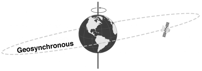
Geo + sync = satellites that are in sync with the rotation of the earth i.e., they take the same time earth takes rotate. There’s a sweet spot above the Earth where a satellite can match the same rotation of the Earth. This special position in high Earth orbit is known as a geosynchronous orbit and it is 35,786 km from the earth. At any inclination, a geosynchronous orbit synchronizes with the rotation of the Earth. More specifically, the time it takes for the Earth to rotate on its axis is 23 hours, 56 minutes, and 4.09 seconds, which is the same as a satellite in a geosynchronous orbit. It is in sync with the earth, but for an observer on the earth, they will appear to move up (north) and down (south) on the horizon.
Geostationary Orbits

They are a type of geosynchronous orbits. While geosynchronous satellites can have any inclination, the key difference from geostationary orbit is the fact that they lie on the same plane as the equator. Geostationary orbits fall in the same category as geosynchronous orbits, but it’s parked over the equator. This one special quality makes it unique from geosynchronous orbits. If you are an observer on the ground, you would see the satellite as if it’s in a fixed position without movement.
Thus, all geostationary satellites are geosynchronous but not vice versa. While both lie on the same plane as the equator, the geosynchronous satellites have a different inclination.
This makes geosynchronous satellites particularly useful for telecommunications and other remote sensing applications.

Polar Orbits
Satellites in polar orbits usually travel past Earth from north to south rather than from west to east, passing roughly over Earth’s poles. These types of satellites observe the entire earth in a day.

Satellites in a polar orbit do not have to pass the North and South Pole precisely; even a deviation within 20 to 30 degrees is still classed as a polar orbit. Polar orbits are a type of low Earth orbit, as they are at low altitudes between 200 to 1000 km.
Sun-synchronous orbit (SSO) is a particular kind of polar orbit. Satellites in SSO, travelling over the polar regions, are synchronous with the Sun. This means they are synchronised to always be in the same ‘fixed’ position relative to the Sun. This means that the satellite always visits the same spot at the same local time – for example, passing the city of Paris every day at noon exactly.
This means that the satellite will always observe a point on the Earth as if constantly at the same time of the day, which serves a number of applications; for example, it means that scientists and those who use the satellite images can compare how somewhere changes over time.
This is because, if you want to monitor an area by taking a series of images of a certain place across many days, weeks, months, or even years, then it would not be very helpful to compare somewhere at midnight and then at midday – you need to take each picture as similarly as the previous picture as possible. Therefore, scientists use image series like these to investigate how weather patterns emerge, to help predict weather or storms; when monitoring emergencies like forest fires or flooding; or to accumulate data on long-term problems like deforestation or rising sea levels.
Often, satellites in SSO are synchronised so that they are in constant dawn or dusk – this is because by constantly riding a sunset or sunrise, they will never have the Sun at an angle where the Earth shadows them. A satellite in a Sun- synchronous orbit would usually be at an altitude of between 600 to 800 km. At 800 km, it will be travelling at a speed of approximately 7.5 km per second. These are also known as Sun Synchronous Orbit.
NAVSTAR or GPS
GPS is a navigation system that uses satellites to determine the location of a GPS receiver on or near Earth’s surface. Owned by the United States government, it consists of three main segments: the Space Segment, Control Segment, and User Segment. The Space Segment consists of at least 31 satellites, 24 of which are operational and orbit Earth at an altitude of 12,550 miles. The User Segment is for civilians and GPS receivers, who receive signals from these satellites to pinpoint their locations. GPS works through trilateration, where GPS receivers listen to signals from at least four satellites and calculate the distance between them. GPS location services have Standard Positioning (SPS) as an approximate system, while Restricted Positioning (RPS) is accurate and precise. SPS is used in civil applications, while RPS is used in military ones.
NAVIC- IRNSS
NAVIC stands for Navigation with Indian Constellation. It was previously known as Indian Regional Navigation Satellite System (IRNSS). It has 7 satellites-
4 Satellites (Geosynchronous)
3 Satellites (Geostationary 36,000 km)
Coverage: India + 1500 Km from Border
Resolution (10 meters)
All of the satellites have been placed
Forthcoming change: To add the L1 Spectrum band into NavIC which is part of GPS and is the most used for civilian navigational use.
The Government of India is pushing smartphone makers to enable support for its NavIC navigation system in new devices from next year. NavIC is an independent stand- alone navigation satellite system
Expansion will help to increase its use in civilian sector and ships, aircraft travelling far from the country’s borders
Application: Public vehicle tracking in India, providing emergency warning alerts to fishermen, tracking and providing information related to natural disasters
Lagrange Points
Lagrange Points
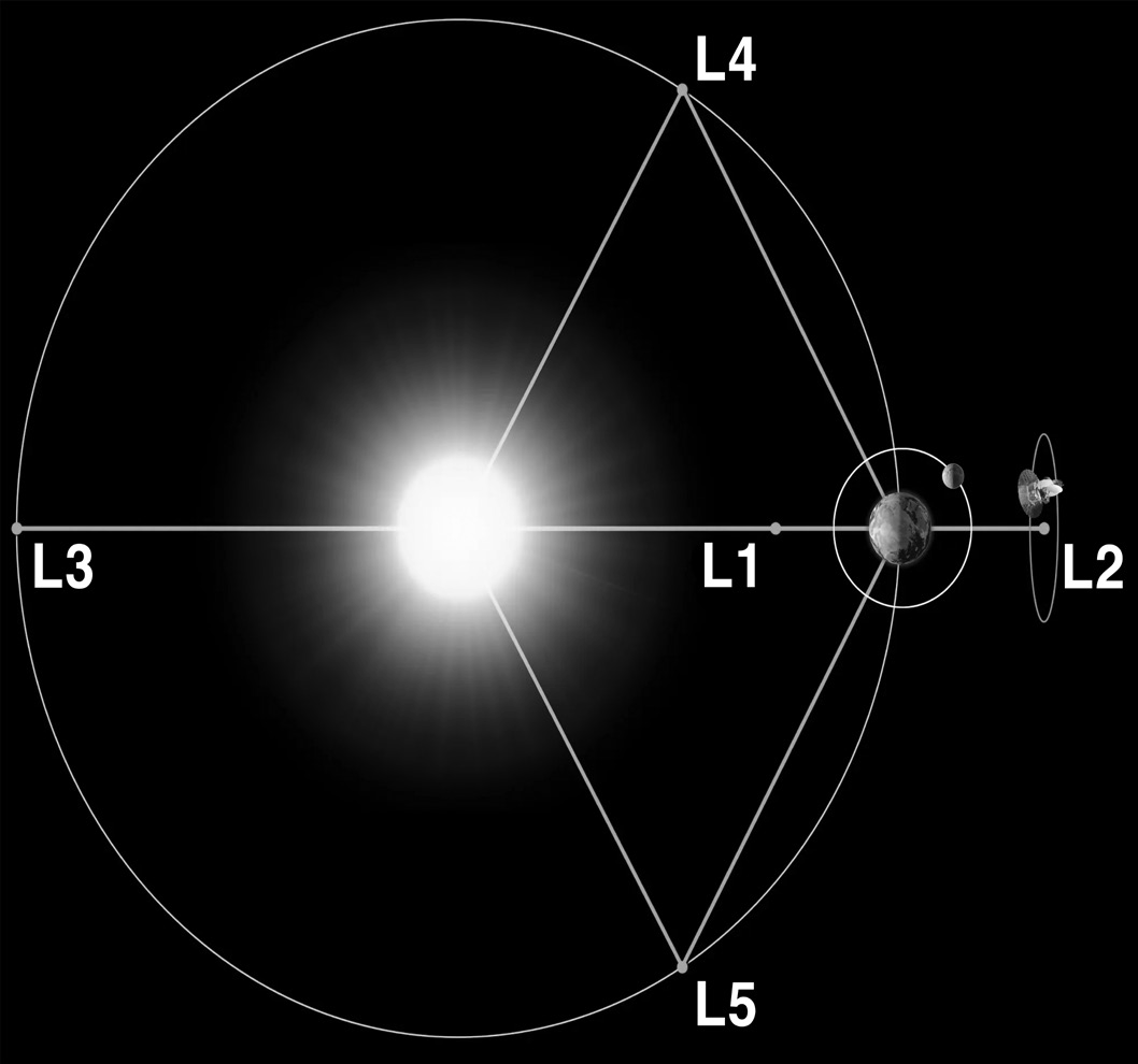
Lagrange points are positions in space where objects sent there tend to stay put. At Lagrange points, the gravitational pull of two large masses precisely equals the centripetal force required for a small object to move with them. These points in space can be used by spacecraft to reduce fuel consumption needed to remain in position. Lagrange Points are positions in space where the gravitational forces of a two- body system like the Sun and the Earth produce enhanced regions of attraction and repulsion. These can be used by spacecraft to reduce fuel consumption needed to remain in position.
These are five special points where a small mass can orbit in a constant pattern with two larger masses.
Of the five Lagrange points, three are unstable and two are stable. The unstable Lagrange points - labelled L1, L2 and L3 - lie along the line connecting the two large masses. The stable Lagrange points - labelled L4 and L5 - form the apex of two equilateral triangles that have the large masses at their vertices. L4 leads the orbit of earth and L5 follows. The L1 point of the Earth-Sun system affords an uninterrupted view of the sun and is currently home to the Solar and Heliospheric Observatory Satellite SOHO.
The L2 point of the Earth-Sun system was the home to the WMAP spacecraft, current home of Planck and the James Webb Space Telescope. L2 is ideal for astronomy because a spacecraft is close enough to readily communicate with Earth, can keep Sun, Earth and Moon behind the spacecraft for solar power and (with appropriate shielding) provides a clear view of deep space for our telescopes. The L1 and L2 points are unstable on a time scale of approximately 23 days, which requires satellites orbiting these positions to undergo regular course and attitude corrections.
Facts to remember:
There are 5 Lagrange points in outer space
Here, the orbit, gravity of sun and the gravity of earth are in balance
If spacecraft is placed on such points, it will remain in a HALO orbit and Earth and the spacecraft together will go round the sun
L1, L2, and L3 points are in unstable equilibrium whereas L4 and L5 points are in stable equilibrium
L4 and L5 are extremely vulnerable to asteroids
Therefore, even though they have stable equilibrium, L5 is preferred
Geosynchronous Transfer Orbit
Geosynchronous Transfer Orbit (GTO)

After lift-off, a launch vehicle makes its way to space following a path shown by the yellow line, in the figure. At the target destination, the rocket releases the payload which sets it off on an elliptical orbit, following the blue line which sends the payload farther away from Earth. The point farthest away from the Earth on the blue elliptical orbit is called the apogee and the point closest is called the perigee.
When the payload reaches the apogee at the GEO altitude of 35 786 km, it fires its engines in such a way that it enters onto the circular GEO orbit and stays there, shown by the red line in the diagram. So, specifically, the GTO is the blue path from the yellow orbit to the red orbit.
A transfer orbit is a HEO, geosynchronous with perigee = 300- 400 km and apogee = 36000 km to 38000 km
This orbit is used for initial launch of a communication satellite or a spacecraft
This orbit is used by space agencies to manoeuvre a satellite for various applications.
India used GTO in case of Mangalyaan.
Geo Centric Phase
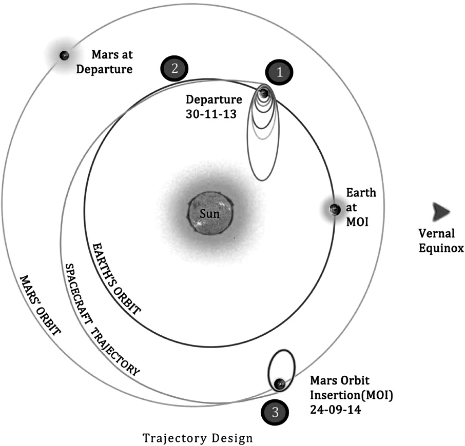
The spacecraft was injected into an Elliptic Parking Orbit by the launcher. With six main engine burns, the spacecraft is gradually maneuverered into a departure hyperbolic trajectory with which it escapes from the Earth’s Sphere of
Influence (SOI) with Earth’s orbital velocity + V boost. The SOI of earth ends at 918347 km from the surface of the earth beyond which the perturbing force on the orbiter is mainly due to the Sun. One primary concern was how to get the spacecraft to Mars, on the least amount of fuel. ISRO used a method of travel called a Hohmann Transfer Orbit – or a Minimum Energy Transfer Orbit – to send a spacecraft from Earth to Mars with the least amount of fuel possible.
Helio-Centric Phase
The spacecraft left Earth in a direction tangential to Earth’s orbit and encountered Mars tangentially to its orbit. The flight path was roughly one half of an ellipse around sun. Eventually it intersected the orbit of Mars at the exact moment when Mars was there too. This trajectory became possible with certain allowances when the relative position of Earth, Mars and Sun formed an angle of approximately
440. Such an arrangement recurs periodically at intervals of about 780 days. Minimum energy opportunities for Earth- Mars occurred in November 2013, January 2016, May2018 etc.
Martian Phase
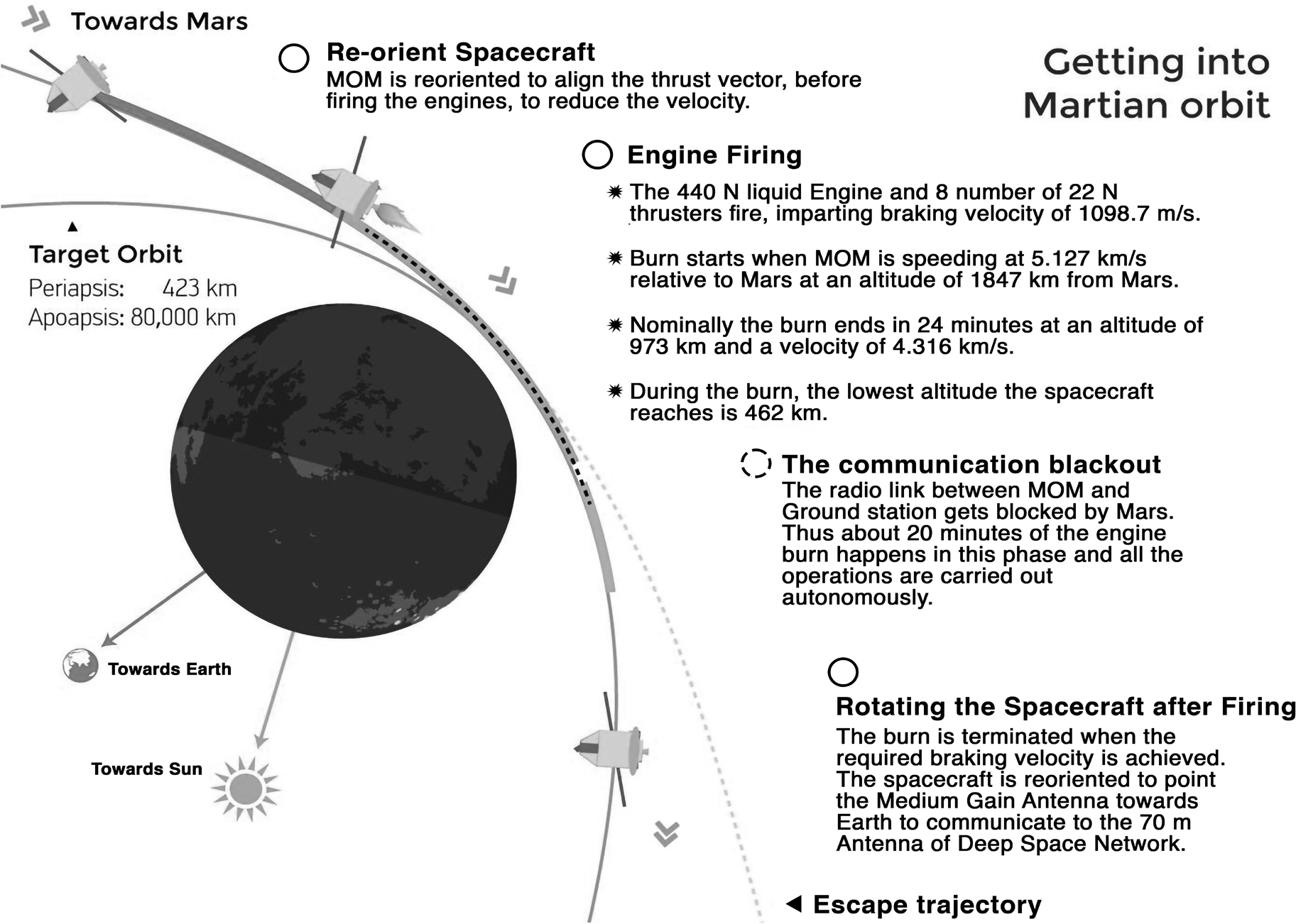
The spacecraft arrived at the Mars Sphere of Influence (around 573473 km from the surface of Mars) in a hyperbolic trajectory. At the time the spacecraft reached the closest approach to Mars (Periapsis), it was captured into planned orbit around mars by imparting ∆V retro which is called the Mars Orbit Insertion (MOI) manoeuvre. The Earth-Mars trajectory is shown in the above figure. ISRO launched the Mars Orbiter Mission during the November 2013 window utilizing minimum energy transfer opportunity.
Earth Satellites
EARTH SATELLITES
Earth satellites are objects that rotate around the Earth. Their velocity is remarkably similar to that of planets around the Sun, therefore Kepler’s laws of planetary motion apply equally to them. Their orbits around the Earth are either circular or elliptic. The moon is the sole natural satellite of the earth that has a nearly circular orbit with a time period of around 27.3 days, which is roughly equivalent to the moon’s rotating period around its own axis. Since 1957, technological advancements have enabled numerous countries, including India, to launch artificial earth satellites for practical applications in telecommunications, geophysics and meteorology.
As we already know,

Now, for a satellite (let’s say, the moon), the centripetal force of the satellite will be balanced by gravity to keep the satellite in orbit. The formula for centripetal force is:

Where ‘V’ is the moon’s speed and R is the distance between Earth and the moon, or R = Radius of Earth R (earth) + Moon’s Distance from Earth, or ‘h’.
Equating these equations, we get,

This indicates that a satellite’s mass does not determine its velocity. The formula above does not include the moon’s mass. Thus, it makes no difference how heavy the satellite is. A satellite’s velocity is determined by its distance from the earth (since the radius of the planet remains constant). They have an inverse relationship: the satellite’s velocity decreases as it moves farther away. Similarly, consider all of the planets around the Sun. Mercury and Venus are far closer to the Sun than Earth, while Jupiter and Saturn are much further. Mercury and Venus have shorter years than Earth, but Jupiter and Saturn take far longer. It is determined only by the planet’s distance, not its mass.
Experimental Satellites
Indian Space Research Organisation (ISRO) has launched many small satellites, primarily for experimental purposes. This experiment covers remote sensing, atmospheric studies, payload development, orbital control, recovery technology and so on.
The Aryabhata spacecraft, named after the famed Indian astronomer, was India’s first satellite; it was totally planned and constructed in India and launched by a Soviet Kosmos- 3M rocket from Kapustin Yar on April 19, 1975.
Other experimental spacecraft from India include the Rohini Satellite RS-1, APPLE, and YOUTHSAT.
Earth Observation Satellites
Earth observation satellites are those equipped with remote sensing capabilities. These satellites use Earth observation to obtain information about the Earth’s physical, chemical,
and biological systems.
These satellites’ data are used in a wide range of applications, including agriculture, water resources, urban planning, rural development, the environment, forestry, ocean resources, and disaster management.
Many earth observation satellites are now in service in sun-synchronous orbits. ISRO has launched several Earth Observation Satellites, including RESOURCESAT-2A, CARTOSAT-1, 2, 2A, 2B, RISAT-1 and 2, OCEANSAT-2,
Megha-Tropiques, SARAL and SCATSAT-1, INSAT-3DR, 3D, and so on.
NISAR: NASA-ISRO Synthetic Aperture Radar
NASA-ISRO SAR (NISAR) is a Low Earth Orbit (LEO) observatory built collaboratively by NASA and ISRO. NISAR will map the entire world in 12 days and offer spatially and temporally consistent data to better understand changes in Earth’s ecosystems, Ice mass, vegetation biomass, sea level rise, ground water, and natural hazards such as earthquakes, tsunamis, volcanoes, and landslides. It carries L and S dual band Synthetic Aperture Radar (SAR), which uses the Sweep SAR technique to capture wide swaths of high-resolution data. The SAR payloads installed on the Integrated Radar Instrument Structure (IRIS) and the spacecraft bus form an observatory. Jet Propulsion Laboratories and ISRO are building an observatory that will not only suit the demands of their respective countries, but will also provide data to the scientific community, stimulating studies on surface deformation measurements using the repeat-pass InSAR technique
Indian Remote Sensing Satellites
Indian Remote Sensing Satellites (IRS System)
The Indian Remote Sensing Satellite System (IRS) is a program of the Indian Space Research Organisation (ISRO) that develops and operates India’s remote sensing satellite fleet. The IRS program was begun in 1988, and it now consists of a constellation of over a dozen satellites used
for a range of purposes, including mapping, surveying and environmental monitoring.
The IRS satellites are outfitted with a variety of specialized instruments, including cameras, sensors and radar, which are designed to collect and send precise data on the Earth and its surroundings. This information is utilized for a wide range of applications, including mapping and surveying,
environmental monitoring and scientific study.
One of the IRS program’s primary goals is to offer high- quality remote sensing data and services to customers in India and around the world. To do this, the IRS program has launched a number of projects and collaborations, including the National Natural Resources Management System
(NNRMS), which offers remote sensing data and services to a variety of government departments and private individuals.
Overall, the Indian Remote Sensing Satellite System is an essential initiative that supports India’s space research and development endeavours. It offers useful information and services to people in India and throughout the world, and it is a critical component of the country’s efforts to understand and protect the Earth and its environment.
IRS Missions
Over the years, the IRS program has undertaken a number of missions to collect and send precise information about the Earth and its environment. The IRS program has launched several significant missions, including:
IRS-1A: The IRS-1A satellite, launched in 1988, was the first in the constellation. It was outfitted with a variety of sensors, including a multispectral camera and a radar imaging sensor, which were used to gather comprehensive data on the Earth’s surface and atmosphere.
IRS-1B: The IRS-1B satellite, launched in 1991, was the second in the IRS constellation. It received upgraded sensors, including a higher-resolution multispectral camera and a new radar imaging sensor.
IRS-1C: The IRS-1C satellite, launched in 1995, was the third in the IRS constellation. It was outfitted with a variety of modern sensors including a new multispectral camera, a radar imaging sensor, and a high-resolution panchromatic camera.
IRS-1D, launched in 1997, was the fourth satellite in the IRS system. It was outfitted with a variety of modern sensors, including a new multispectral camera, a radar imaging sensor and a high-resolution panchromatic camera.
The IRS-P6 (Resourcesat-2) satellite, launched in 2011, was the sixth in the IRS constellation. It was outfitted with a variety of advanced sensors, including a high- resolution multispectral camera, a radar imaging sensor
and a high-resolution panchromatic camera.
IRS-P7 (Cartosat-2A), launched in 2008, was the sixth satellite in the IRS system. It was outfitted with a high- resolution panchromatic camera that was intended to capture detailed photos of the Earth’s surface for a number of purposes such as mapping, surveying and environmental monitoring.
• The IRS-P8 (Resourcesat-2A) satellite, launched in 2016, is the seventh in the IRS constellation. It was outfitted with a variety of advanced sensors, including a high-resolution multispectral camera, a radar imaging sensor and a high- resolution panchromatic camera.
• The IRS-P9 (Cartosat-2B) satellite, launched in 2017, was the eighth mission in the series.
Applications Of Indian Remote Sensing Satellites
The Indian Remote Sensing (IRS) satellites’ valuable data have tremendously benefited a wide range of applications. These applications span multiple industries and contribute to India’s environmental management and socioeconomic growth. IRS satellites are primarily used for the following purposes
• IRS satellites help manage agricultural efficiently. They provide information for better water resource management, forecasting pest and disease outbreaks, calculating yields, and monitoring crops.
• IRS data is used for forest management, including mapping and tracking deforestation. It aids in fire detection, species identification, and evaluation of forest cover.
• IRS satellites assist with water resource management, including river basin planning, reservoir maintenance, and flood prediction. They also support assessing the availability and quality of water.
• Urban planners use IRS data to track land usage, construct infrastructure, and plan cities. This is critical for efficient resource allocation and long-term urban growth.
• IRS data is used in rural development initiatives such as infrastructure planning, watershed management, and soil health assessments.
• Cartography and Mapping: Topographic surveys, map production, and cartography rely on high-resolution imagery from satellites such as Cartosat.
• IRS data can help with infrastructure development, including transportation planning, energy infrastructure, and industrial site selection.
• IRS satellites, outfitted with atmospheric sensors, provide weather forecasting and climate research data. They support climate change modeling as well as monitoring.
• IRS satellites aid in security and defense by identifying targets, monitoring borders, and providing situational awareness.
• Remote sensing data can be used to plan healthcare activities and track the spread of vector-borne illnesses such as malaria.
Indian Satellite (INSAT)
The Indian National Satellite (INSAT) system is one of the largest domestic communication satellite systems in Asia-Pacific, with nine active communication satellites in geostationary orbit.
Established in 1983 with the commissioning of INSAT-1B, it sparked a dramatic transformation in India’s communications sector and continued it subsequently.
The INSAT system, which has over 200 transponders in the C, Extended C, and Ku bands, serves telecommunications, television transmission, satellite newsgathering, societal
applications, weather forecasting, catastrophe warning, and search and rescue activities.
ExceedSat-1 (India’s 1st Private Satellite)
Exseed Space has become India’s first privately funded business to successfully launch a satellite into space.
Space X launched ExseedSAT-1 into space, together with 63 other satellites from 17 countries.
Regarding ExseedSAT 1 and its applications-
• The small communication satellite, weighing only one kilogram and measuring double the size of a Rubik’s cube (10 cm x 10 cm x 10 cm), is composed of aluminum alloy.
• The satellite aims to serve the amateur radio community.
• The satellite, which has a five-year lifespan, will allow users to receive signals on the 145.9 Mhz frequency using a television tuner.
• The satellite would provide a significant boost to commercial radio operators, allowing them to coordinate messages and assist the country in times of calamity.
Remote Sensing Satellites by ISRO
Starting with IRS-1A in 1988, ISRO has launched many operational remote sensing satellites. Today, India has one of the largest constellations of remote sensing satellites in operation. Varieties of instruments have been flown onboard these satellites to provide necessary data in a diversified spatial, spectral and temporal resolutions to cater to different user requirements in the country and for global usage. The data from these satellites are used for several applications covering agriculture, water resources, urban planning, rural development, mineral prospecting, environment, forestry, ocean resources and disaster management. These satellites are EOS (Earth Observation Satellites), CARTOSAT (for mapping applications in various arenas), RISAT (Radar Imaging Satellite), INSAT (Indian National Satellite- used for various purposes to provide low-cost solutions), RESOURCESAT (for resource mapping and exploration in various departments, for ex: mineral and oil) or IRS (Indian Remote Sensing Satellites).
• Survey and management of Natural resources (Forest, Agri, wetlands)
Mineral prospecting: Locating minerals via Satellite (Resource SAT- 1, 2A, 2B)
Cartography (Contour maps): (CARTOSAT) (GIS: geographical info system)
Bhuvan System: Collaboration between Map My India and ISRO: Indigenous Geo-Spatial Portal
Oceanography: mapping and study of geography. Ex: OCEANSAT (4-5)
• SCATSAT-1 has replaced OCEANSAT 2-A
• SARAL: Satellite for ARGUS and ALTIGA (ISRO) and CNES (France)
•
Environment: Pollution management
• NISAR: observation of changes our earth (Land S band.)
• NISAR: Nasa ISRO Synthetic Aperture Radar: A Collaboration between India and NASA for a dual frequency satellite.
• Disaster Management: Hazard Mapping of disaster- prone areas
• RISAT is a Radar Imaging Earth Observation Satellite. The satellite will provide services in the field of Agriculture, Forestry and Disaster Management.
Satellite Navigation
SATELLITE NAVIGATION
Satellite Navigation service is an emerging satellite-based system with commercial and strategic applications. ISRO is committed to provide the satellite-based Navigation services to meet the emerging demands of the Civil Aviation requirements and to meet the user requirements of the positioning, navigation and timing based on the independent satellite navigation system. To meet the Civil Aviation requirements, ISRO is working jointly with Airport Authority of India (AAI) in establishing the GPS Aided Geo Augmented Navigation (GAGAN) system. To meet the user requirements of the positioning, navigation and timing services based on the indigenous system, ISRO is establishing a regional satellite navigation system called Indian Regional Navigation Satellite System (IRNSS).
GPS Aided GEO Augmented Navigation (GAGAN)
This is a Satellite Based Augmentation System (SBAS) implemented jointly with Airport Authority of India (AAI). The main objectives of GAGAN are to provide Satellite-based Navigation services with accuracy and integrity required for civil aviation applications and to provide better Air Traffic Management over Indian Airspace. The system will be interoperable with other international SBAS systems and provide seamless navigation across regional boundaries. The GAGAN Signal-In-Space (SIS) is available through GSAT-8 and GSAT-10.
Facts to remember-
• Airports Authority of India (AAI) successfully conducted flight trials using GAGAN based LPV approach procedure.
• India is the first country in the Asia Pacific Region to achieve such a landmark in field of Air Navigation Services (ANS)
• LPV (Localizer Performance with Vertical Guidance) permits aircraft guided approaches that are operationally nearly equivalent to Category 1- Instrument Landing System (Cat-1 ILS), without the need for ground-based navigational infrastructure. In short, GAGAN helps planes to land without ground markers
• GAGAN is an Indian Satellite Based Augmentation System (SBAS) jointly developed by AAI and ISRO for India and neighbouring countries in the equatorial region.
• It is one among the only four Space-Based augmentation systems available in the world which also includes US(WAAS) Europe (EGNOS) and Japan (MSAS)
• Benefits of GAGAN: Air traffic control, manage road and railways transport, help farmers in crop spraying etc.
Indian Regional Navigation Satellite System (IRNSS): NavIC
This is an independent Indian Satellite based positioning system for critical National applications. The main objective is to provide Reliable Position, Navigation and Timing services over India and its neighbourhood, to provide fairly good accuracy to the user. The IRNSS will provide basically two types of services
• Standard Positioning Service (SPS)
• Restricted Service (RS)
To date, ISRO has built a total of nine satellites in the IRNSS series; of which eight are currently in orbit Three of these satellites are in geostationary orbit (GEO) while the remaining in geosynchronous orbits (GSO) that maintain an inclination of 29 to the equatorial plane. The IRNSS constellation was named as “NavIC” (Navigation with Indian Constellation) by the Honourable Prime Minister and dedicated to the nation on the occasion of the successful launch of the IRNSS-1G satellite.
Why satellites do not fall down?
Satellites orbit Earth due to a balance between the gravitational pull of the planet and their forward velocity. This allows them to fall towards Earth due to gravity and move forward at a sufficient speed to miss the planet’s surface. The satellite’s forward velocity creates a centrifugal force, which opposes the pull of gravity. When these forces are balanced, the satellite’s trajectory becomes an elliptical orbit around Earth.
Atmospheric drag, a thin atmosphere at the outer edges of Earth’s atmosphere, slightly slows down satellites over time, causing them to lose altitude. Some satellites have thrusters or propulsion systems to adjust their orbits and counteract atmospheric drag. Satellites in higher orbits, such as geostationary orbit or deep space, experience less drag and can remain in orbit for longer periods without significant adjustments.
Basic Concepts
• Satellite: A satellite is a moon, planet, or machine that orbits a planet or star, such as Earth is a satellite (as it orbits around the sun) and the moon is a satellite (as it orbits around the earth). Natural satellites include Earth and the moon, while thousands of artificial satellites orbit Earth. Some take pictures of the planet to help meteorologists predict weather and track hurricanes, while others take pictures of other planets, black holes, dark matter, or distant galaxies to better understand the solar system and universe. Other satellites are used for communications, such as beaming TV signals and phone calls around the world. The Global Positioning System (GPS) consists of over 20 satellites, which can help determine an individual’s exact location with a GPS receiver.
•
Space Shuttle: The Space Shuttle, developed by NASA, was a partially reusable rocket-launched vehicle designed to orbit Earth, transport people and cargo and glide to a runway landing upon return. Originally called the Space Transportation System (STS), it launched its first flight on April 12, 1981 and made 135 flights until its program ended in 2011. Key components of the Space Shuttle system included-
• a winged orbiter that carried both crew and cargo;
• an external tank containing liquid hydrogen (fuel) and liquid oxygen (oxidizer) for the orbiter’s three main rocket engines;
• a pair of large, solid-propellant, strap-on booster rockets - During the launch, the boosters and the orbiter’s main engines ignited simultaneously, increasing thrust. The boosters were ejected after liftoff and returned to Earth for reuse.
• Spacecrafts: A spacecraft is a vehicle designed to fly in outer space, used for various purposes such as communications, Earth observation, meteorology, navigation, space colonization, planetary exploration, and transportation of humans and cargo. Spacecraft require a launch vehicle and can enter space and return to the surface without gaining enough energy or velocity to make a full orbit of Earth. Orbital spaceflights involve entering closed orbits around Earth or other celestial bodies. Human spaceflight uses crew or passengers, while robotic space missions operate autonomously or telerobotically. Space probes support scientific research, while artificial satellites remain in orbit around planetary bodies.
• Launch Vehicle: A launch vehicle is a rocket-powered vehicle used in spaceflight to transport spacecraft beyond Earth’s atmosphere, either into orbit or to outer space. Launch vehicles have been used since the 1950s to send crewed, uncrewed probes and satellites. India’s used launch vehicles are as follows: RLV-TD, SLV, ASLV, PSLV and GSLV.
• Rocket: A rocket is a vehicle that uses Newton’s third law of motion to propel itself by exhaling exhaust gases at high speeds. It operates in space or Earth’s atmosphere, serving various purposes like space exploration, satellite deployment, scientific research, and military applications. Rockets are essential for enabling humans and payloads to reach outer space.
• Missile: A missile is a guided self-propelled weapon system used for various purposes, including military, defense, and scientific research. It is propelled by engines or motors and equipped with guidance systems to ensure accuracy in hitting its intended targets.
Launch Vehicle Technology
LAUNCH VEHICLE TECHNOLOGY
Launchers or Launch Vehicles are used to carry spacecraft to space. Launch Vehicles are of two types-
| Expendable Launch Vehicles (ELV) | Reusable Launch Vehicles (RLV) |
| Used only once for a space mission E.g.: PSLV, GSLV | Can be used multiple times |
| Space debris issues | Returns back to earth |
| Used for Unmanned missions | Can be used for both manned and unmanned missions |
| India only has ELV, working to develop RLV | Advantage is that it is reusable and saves lot of money |
Overview of ISRO’s Launch Vehicles
• India has three active operational launch vehicles: Polar Satellite Launch Vehicle (PSLV), Geosynchronous Satellite Launch Vehicle (GSLV), Geosynchronous Satellite Launch Vehicle Mk-III (LVM3).
• The Small Satellite Launch Vehicle (SSLV), Human Rated Launch Vehicle (HRLV) under the Mission Gaganyaan and the Reusable Launch Vehicle – Technology Demonstrator (RLV-TD) are under development.
• PSLV is configured with four variants like 6,4,2 solid rocket strap-on motors & core alone versions. Variants will be chosen based on the payload weights & orbit to be accomplished. PSLV has been a versatile launch vehicle deployed for launching all the three types of payloads viz. Earth Observation, Geo-Stationary and Navigation. It has got highest success rate and considered as work horse of ISRO.
• GSLV with indigenous Cryogenic Upper Stage has enabled the launching up to 2 tonne class of communication satellites.
• The LVM3 is the next generation launch vehicle capable of launching 4 tonne class of communication satellites and 10 tonne class of payloads to LEOs. The vehicle was developed with completely indigenized technologies including the C25 cryo stage. The launch vehicle has a track record of all successful launches even from the first development flight. The Human rated LVM3 is identified as the launch vehicle for Gaganyaan mission, which is named as HRLV.
• The Small Satellite Launch Vehicle (SSLV) is being developed with complete indigenous technologies to meet the small satellite launch market on demand driven basis.
First Generation: Satellite Launch Vehicle
Satellite Launch Vehicle-3 (SLV-3) was India’s first experimentalsatellite launch vehicle, weighing
17 tonnes and standing 22 metres tall,capable of launching 40 kg payloads into Low Earth Orbit (LEO). On July 18, 1980, SLV-3 was successfully launched from Sriharikota Range (SHAR), and the Rohini satellite, RS-1, was sent into orbit, making India the sixth member of an elite club of space-faring nations.
SLV-3usedopenloopguidance(withastoredpitchprogramme) to steer the vehicle in flight along a predetermined path. The first experimental flight of the SLV-3, in August 1979, was only partly successful. Apart from the July 1980 launch, two more Rohini satellites carrying remote sensing sensors were launched in May 1981 and April 1983, respectively. The successful completion of the SLV-3 project paved the door for further sophisticated launch vehicle projects, including the Augmented Satellite Launch Vehicle (ASLV), Polar Satellite Launch Vehicle (PSLV), and Geosynchronous Satellite Launch Vehicle.
Second Generation: Augmented Satellite Launch Vehicle (ASLV)
With a lift-off weight of 40 tonnes, the 24 m tall ASLV was designed as a five-stage, all-solid propellant vehicle with the purpose of orbiting 150 kg class satellites in 400 km circular orbits.
The Augmented Satellite Launch Vehicle (ASLV) Programme was created to increase the payload capacity to 150 kg, three times that of SLV-3, for Low Earth Orbits. Building on the experience gained from the SLV-3 missions, ASLV proved to be a low-cost intermediate vehicle for demonstrating and validating critical technologies required for future launch vehicles, such as strap-on technology, inertial navigation, bulbous heat shield, vertical integration and closed-loop guidance.
Four developmental flights were done as part of the ASLV programme. The first developmental flight occurred on March 24, 1987 and the second on July 13, 1988. The third developmental mission, ASLV-D3, was successfully launched on May 20, 1992, when SROSS-C (106 kg) was placed into a 255 x 430 km orbit. ASLV-D4, launched on May 4, 1994, orbited SROSS-C2, which weighed 106 kg. It carried two payloads: the Gamma Ray Burst (GRB) Experiment and the Retarding Potentio Analyser (RPA), and it operated for seven years.
Third Generation: Polar Satellite Launch Vehicle (PSLV)
PSLV is India’s third generation launch vehicle. It is the first Indian launch vehicle to be fitted with liquid stages. After its first successful launch in October 1994, PSLV established itself as India’s reliable and adaptable workhorse launch vehicle. The vehicle has launched several Indian and foreign customer satellites. Furthermore, the vehicle successfully
launched two spacecraft, Chandrayaan-1 in 2008 and Mars Orbiter Spacecraft in 2013, which later travelled to the Moon and Mars, respectively. PSLV had Chandrayaan-1 and MOM as feathers in its hat. PSLV-C48 is the 50th launch of PSLV.
PSLV gained the term ‘the workhorse of ISRO’ for continuously delivering various satellites into low earth orbits, particularly the IRS series of satellites. PSLV has been utilized to launch different satellites into geosynchronous and geostationary orbits, such as satellites from the IRNSS Constellation, due to its unequalled reliability.
The PSLV can launch numerous payloads into orbit, hence multi-payload adaptors are employed in the payload fairing. The vehicle’s payload performance and mission adaptability are demonstrated by the complex missions that involve many orbits and satellites. The long series of consecutive successes and multi-satellite launch capability has cemented PSLV’s standing as a dependable, adaptable and economical launcher in the worldwide market.
Facts to remember-
• The launch vehicle has four stages, with two solid and two liquid fuels.
• It is typically used for smaller satellites.
• Types of PSLV
• PSLV-CA: PSLV Core
• PSLV Standard Configuration: PSLV- CA and six strap on motors
• PSLV- XL: with six boosters, high-capacity rocket
• PSLV- QL and PSLV- DL
• Strap-on Motors
• The PSLV-XL, QL, and DL variants rely on 6,4,2 solid rocket strap-on engines to supplement the first stage thrust. However, strap-on rockets are not employed in the core-only version (PSLV-CA).
• Payload it can carry to SSPO (Sun Synchronous Polar Orbit): 1,750 kg
• PSLV is known as ‘the Workhorse of ISRO’ due to its regular delivery of satellites to Low Earth Orbits. It can transport up to 1,750 kg of payload to Sun- Synchronous Polar Orbits at 600 km altitude.
• Payload it can carry to Sub GTO: 1,425 kg
• PSLV has been utilized to launch satellites into geosynchronous and geostationary orbits, including those from the IRNSS constellation, due to its high reliability.
Fourth Generation: Geosynchronous Satellite Launch Vehicle (GSLV)
India developed the Geosynchronous Satellite Launch Vehicle (GSLV) to launch communication satellites into geo transfer orbit using a cryogenic third stage. Initially, Russian-supplied cryogenic stages were employed. The cryogenic stage was later built in-house and introduced
in January 2014, beginning with GSLV D5. This operating fourth-generation launch vehicle consists of three stages and four liquid strap-on rockets. The GSLV Mk II’s third stage is the flight-proven, indigenously produced Cryogenic Upper Stage (CUS). Since January 2014, the car has enjoyed six straight successes.
Facts to remember-
It has three types-
Mk I- this is the GSLV Core
Mk II- This has 4 strap-on motors
Mk III- Solid 200- divides the first solid stage fuel into two pieces to provide additional boost, and is utilized for larger satellites.
• It has a three-stage fuel burn: Solid, Liquid and Cryogenic stages.
• First Stage: GS1
• The first stage of GSLV is derived from the PSLV’s PS1.
• The 138-tonne solid rocket motor is augmented by 4 liquid strap-ons
• Second Stage: GS2
• The second stage of the GSLV uses a single Vikas engine.
• The stage was derived from the PS2 of PSLV, when the Vikas engine demonstrated reliability.
• Third Stage: CUS
• The Liquid Propulsion Systems Centre produced India’s first cryogenic engine, the CE-7.5, as part of the Cryogenic Upper Stage Project (CUSP).
• Payload to GTO: 2,250 kg
• GSLV’s principal payloads are INSAT communication satellites, which operate from geostationary orbits and are deployed in geosynchronous transfer orbits.
• Payload to LEO (Low Earth Orbit): 6,000 kg
Further, GSLV’s capability of placing up to 6 tonnes in Low Earth Orbits broadens the scope of payloads from heavy satellites to multiple smaller satellites.
Fifth Generation: GSLV MK-III
LVM3 has three stages: two solid strap-on motors (S200), one liquid core stage (L110), and a high thrust cryogenic upper stage (C25). The S200 solid motor is one of the world’s largest solid boosters, containing 204 tons of solid propellant. The liquid L110 stage employs a dual liquid engine configuration with 115 tonnes of liquid propellant, and the C25 Cryogenic upper stage employs the wholly indigenous high thrust cryogenic engine (CE20) with a fuel loading of 28 tonnes.
LVM3 is ISRO’s latest heavy lift launch vehicle, designed to send 4000 kg spacecraft to GTO (Geosynchronous Transfer Orbit) in a cost-effective manner. LVM3 is a three-stage launch vehicle made up of two solid propellant S200 strap-
ons and core stages that include the L110 liquid stage, C25 cryogenic stage, equipment bay (EB), and encapsulated assembly (EA). EA consists of the spacecraft, the Payload Adaptor (PLA), and the Payload Fairing (PF). With a lift-off mass of 640 tons, this 43.5 m tall three-stage launch vehicle allows ISRO complete independence in launching bigger communication satellites weighing up to 4000 kg in GTO.
The vehicle takes off with the firing of both S200 boosters. The core stage (L110) is fired at approximately 113 seconds into the flight, during the firing of the S200 stages. Both S200 motors fire for approximately 134 seconds before separating at 137 seconds. During L110 firing, the payload fairing separates at an altitude of 115 km and takes around 217 seconds. At 313s, the L110 burns out and separates, followed by the C25 ignition. The spacecraft is injected into a 180x36000 km GTO (Geosynchronous Transfer Orbit) orbit in 974 seconds.
Facts to remember-
• Core Stage: L110 Liquid Stage
• The L110 liquid stage is powered by two Vikas engines developed at the Liquid Propulsion Systems Center.
• Solid Rocket Boosters: S200
• LVM3 relies on two S200 solid rocket boosters to generate significant thrust during liftoff. The S200 was designed at the Vikram Sarabhai Space Center.
• Cryogenic Upper Stage: C25
• The Liquid Propulsion Systems Centre conceived and constructed the CE-20, India’s largest cryogenic engine, which powers the C25.
• Payload to LEO (Low Earth Orbit): 8,000 kg
• LVM3’s cryogenic stage can launch big payloads into 600 km low Earth orbits.
• Payload to GTO: 4,000 kg
• LVM3 can launch 4 tonne GSAT satellites into geosynchronous transfer orbits.
Miscellaneous: Launch vehicle and Missiles
Small Satellite Launch Vehicle (SSLV)
Small Satellite Launch Vehicle (SSLV) is a 3 stage Launch Vehicle configured with three Solid Propulsion Stages and liquid propulsion-based Velocity Trimming Module (VTM) as a terminal stage. SSLV is 2m in diameter and 34m in length with lift off weight of ~120 tonnes. SSLV is capable of launching ~500kg satellite in 500km planar orbit from SDSC/SHAR. The key features of SSLV are Low cost, with low turn-around time, flexibility in accommodating
multiple satellites, Launch on demand feasibility, minimal launch infrastructure requirements, etc.
Facts to remember-
• Vehicle Configuration
• 2m diameter x 34m long
•
Lift off mass: ~120T
• Three Solid propulsion stages
• Liquid module as terminal stage
• Payload Capability
• Single/Multi Satellites - Nano, Micro and Mini satellites
• Single Satellite up to 500kg in 500km planar orbit
• Three Multiple satellites ranging from 10kg to 300kg into 500km Planar Orbit
• Velocity Trimming Module (VTM)

• Velocity Trimming Module based on 50N Bipropellant Thrusters with 8 nos. of 50N thrusters for RCS and 8 nos. of 50N axial thrusters of Velocity addition.
Reusable Launch Vehicle (RLV)
Reusable Launch Vehicle – Technology Demonstrator (RLV-TD) is one of the most technologically challenging endeavours of ISRO towards developing essential technologies for a fully reusable launch vehicle to enable low-cost access to space. The configuration of RLV-TD is similar to that of an aircraft and combines the complexity of both launch vehicles and aircraft. The winged RLV-TD has been configured to act as a flying test bed to evaluate various technologies, namely, hypersonic flight, autonomous landing and powered cruise flight. In future, this vehicle will be scaled up to become the first stage of India’s reusable two stage orbital launch vehicle.
RLV-TD consists of a fuselage (body), a nose cap, double delta wings and twin vertical tails. It also features symmetrically placed active control surfaces called Elevons and Rudder. This technology demonstrator was boosted to Mach no: 5 by a conventional solid booster (HS9) designed for low burn rate. The selection of materials like special alloys, composites and insulation materials for developing an RLV-TD and the crafting of its parts is very complex and demands highly skilled manpower. Many high technology machinery and test equipment were utilised for building this vehicle.
ISRO’s Own Next-Gen Launch Vehicle (NGLV)
The Indian Space Research Organisation (ISRO) is developing a Next-Generation Launch Vehicle (NGLV) to replace operational systems such as the Polar Satellite Launch Vehicle.
ISRO is considering NGLV, a cost-effective, three-stage to orbit, reusable heavy-lift vehicle with a payload capacity of ten tonnes to Geostationary Transfer Orbit (GTO).
Its strong architecture enables bulk manufacturing, adaptability in systems sub-systems and stages, and quick turnaround times.
Features-
The booster stages will use semi-cryogenic propulsion (refined kerosene as fuel and liquid oxygen (LOX) as an oxidizer).
Potential applications include-
• launching communication satellites,
• distant space missions,
• future human spaceflight, and
• cargo missions.
India’s Anti-Satellite (A-SAT) Missile/Mission Shakti
On March 27, 2019, the Defence Research and Development Organisation (DRDO) successfully neutralised a satellite
in space using an anti-satellite (ASAT) missile as part of Mission Shakti. The successful operation revealed DRDO’s technical capability and ability to defend the country’s assets in space, which is the fourth dimension of combat. The ASAT missile, designated as Prithvi Defence Vehicle Mark-II, takes off to intercept the satellite. It is part of India’s Ballistic Missile Defense Programme. Mission Shakti was a successful ASAT missile test after the interceptor collided with a test satellite in low Earth orbit (LEO) at an altitude of 283 km (176 mi).
The mission was one of the most complex operations undertaken by DRDO, requiring a ground-launched missile to target and deactivate a fast-moving satellite in orbit hundreds of kilometers distant.
Reusable Launch Vehicle- Technology Demonstrator (RLV-TD)
The Reusable Launch Vehicle - Technology Demonstrator (RLV-TD) is one of ISRO’s most technologically complex projects aimed at developing fundamental technologies for a fully reusable launch vehicle that will enable low- cost access to space. RLV-TD is configured similarly to an airplane, combining the complexity of both launch vehicles and planes.
The winged RLV-TD has been designed to serve as a flying test bed for evaluating several technologies, including hypersonic flight, autonomous landing, and powered cruise flight. In the future, this vehicle will be upgraded to become the first stage of India’s reusable two-stage orbital launch vehicle.
The RLV-TD consists of a fuselage (body), a nose cap, double delta wings, and twin vertical tails.
It also has symmetrically arranged active control surfaces known as Elevons and Rudder. This technological demonstration was propelled to Mach 5 by a conventional solid booster (HS9) optimized for low burn rates.
The selection of materials such as specific alloys, composites, and insulation materials for the development of an RLV-TD, as well as the manufacture of its components, is extremely difficult and requires highly specialized labor. This vehicle was built using a large amount of high-tech machinery and test equipment.
Jet Engine Technology
JET ENGINE TECHNOLOGY
What is a jet engine?
A jet engine is a machine that turns energy-dense liquid fuel into a forceful pushing force known as thrust. The thrust of one or more engines propels a plane forward, forcing air past its scientifically formed wings to create an upward force known as lift, which propels it into the sky. That, in a nutshell, is how planes work—but how do jet engines work?
Jet Engines and Car Engines
Modern jet engines can be understood by comparing them to
piston engines used in early airplanes, which are remarkably similar to those used in vehicles today. A piston engine (also known as a reciprocating engine because the pistons move back and forth, or “reciprocate”) generates power in strong steel “cooking pots” known as cylinders. Fuel is squirted into the cylinders using atmospheric air. The piston in each cylinder compresses the mixture, raising its temperature until it either ignites spontaneously (in a diesel engine) or with the assistance of a spark plug (in a gas engine).
The burning gasoline and air explode and expand, forcing the piston back out and turning the crankshaft, which powers the car’s wheels (or the plane’s propeller), before repeating the four-step cycle. The problem is that the piston is only driven during one of the four phases, therefore it generates power for just a portion of the time. The amount of power produced by a piston engine is directly proportional to the size of the cylinder and the distance the piston travels; unless you utilize large cylinders and pistons (or a lot of them), you’ll only be able to generate moderate quantities of power. If a plane is powered by a piston engine, its speed, lift, size, and carrying capacity are all limited.
A jet engine operates on the same scientific premise as a car engine: it burns fuel and air (via a chemical reaction known as combustion) to produce energy that propels a plane, vehicle, or other equipment. Instead of using cylinders that go through four phases in turn, it employs a long metal tube that repeats the same four steps in a straight-line sequence. The simplest sort of jet engine, known as a turbojet, draws air in at the front through an inlet (or intake), compresses it by a fan, mixes it with fuel, and combusts it before firing out as a hot, fast-moving exhaust at the back.
Three things make a jet engine more powerful than a car’s piston engine-
According to the law of conservation of energy, a jet engine requires more fuel to generate more power per second. A jet engine is painstakingly engineered to collect large amounts of air and burn it with large amounts of fuel (about 50 parts air to one part fuel), hence the major reason it produces more power is because it can burn more fuel.
Jet engines deliver maximum power continuously due to simultaneous intake, compression, combustion and exhaust (unlike piston engines with a single cylinder).
Jet engines use many turbine “stages” to extract energy, unlike piston engines that only use one stroke. This significantly improves its efficiency.
Gas turbines
A gas turbine is a more technical term for a jet engine, and while it may not be immediately evident what it implies, it is a much better description of how this type of engine operates. A jet engine operates by burning fuel in air, resulting in hot exhaust gas. Unlike an automobile engine, which utilizes exhaust explosions to push its pistons, a jet engine propels the gas past the blades of a windmill-like rotating wheel (a
turbine), causing it to rotate. So, in a jet engine, exhaust gas drives a turbine, hence the name gas turbine.
Action and Reaction
When we think of jet engines, we typically see rocket-like tubes that fire exhaust gas backward. Newton’s third law of motion states that as the exhaust gas from a jet engine shoots back, the plane must move forward. It’s similar to a skateboarder kicking back on the concrete to propel themselves ahead; in a jet engine, the “kick” comes from the exhaust flow. In layman’s terms, the action (the force of the exhaust gas flying backward) is equal and opposite to
the reaction (the force of the plane moving forward); the action moves the exhaust gas, whilst the response moves the plane.
However, not all jet engines operate in this manner; some emit very no rocket exhaust at all. Instead, the turbine harnesses the majority of its power and the shaft connecting to the turbine powers a propeller (in a propeller airplane), a rotor blade (in a helicopter), a massive fan (in a large passenger jet), or an energy generator (in a gas turbine power plant).
Types of Jet engines
Because all jet engines and gas turbines operate in a similar manner (pulling air through an inlet, compressing it, combusting it with fuel, and allowing the exhaust to expand through a turbine), they all share five key components: an inlet, a compressor, a combustion chamber, and a turbine
(arranged in that order) with a driveshaft connecting them.
But that’s where similarities end. Different types of engines contain additional components (powered by the turbine), the inlets function differently, there may be more than one combustion chamber, two or more compressors and several turbines. In addition, the application (the task that the engine must perform) is critical. Aerospace engines are created by painstaking engineering compromise:they must produce the most power from the least amount of fuel (in other words, with maximum efficiency) while remaining as tiny, light, and quiet as feasible. Gas turbines used on the ground (for example, in power plants) do not have to make the same compromises; they do not need to be tiny or light, but they do require maximum power and efficiency.
Normal Aircraft vs. Jet Plane
Normal aircraft use light-weight piston engines or gas turbines, whereas advanced jet planes use turbojet, ramjet, and scramjet engines.
Normal airplanes move in the troposphere,whereas jet planes move very effortlessly and smoothly in the stratosphere. The stratosphere sits above the troposphere. The stratosphere reaches an altitude of 50 kilometers. The stratosphere’s airflow is substantially less turbulent than the troposphere’s.
Because the air does not flow up and down but rather parallel to the Earth in very fast moving air streams, this is where the majority of jet planes travel.
Types of Jet Plane
Jet engine technology is based on Newton’s third law of action and response. Any form of jet engine follows three principles: compression, combustion and expansion.
There are three forms of jet engine technology-
Turbojet,
Ramjet, and
Scramjet.
Turbojet
Turbojet engines are widely used in cruise missiles because of their small size, simplicity, and ability to maintain high speeds over long distances.
The turbojet can fly at approximately 40 kilometers altitude.
Ramjet
Jet engines draw in air at high speeds, thus if you constructed the entrance as a fast-narrowing nozzle, you could have it compressed the incoming air automatically, without the need for a compressor or a turbine. This type of engine is known as a ramjet, and because it requires quick air movement, it is best suited for supersonic and hypersonic (faster-than- sound) aircraft.
A ramjet employs the ram effect, or compression in an inlet, for all compression in an engine. As a result, it has no rotor or blades; instead, the inlet compresses the air (by a sequence of internal/external shocks), ignites it, and shoots it out the back through the nozzle.
Ramjets must run at high speeds due to the amount of flow energy required. They are unable to draw air at a stop. As air moves faster than sound into the engine, it is compressed and slowed considerably to subsonic speeds before being blended with fuel and ignited by a device known as a flame holder, producing a rocket-like exhaust similar to that of a classic turbojet. Ramjets are commonly employed in rocket and missile engines, however they are not suitable for use in space because they “breathe” air.
Scramjets are similar, but the supersonic air does not slow down nearly as much as it passes through the engine. By remaining supersonic, the air exits at a significantly higher speed, allowing the plane to travel far faster than a ramjet (theoretically up to Mach 15, or 15 times the speed of sound— in the “high hypersonic” range).
Scramjets
A scramjet (supersonic-combustion ramjet) is a ramjet engine that maintains supersonic airflow throughout its operation.
This allows the scramjet to go faster than a standard ramjet, which must decrease incoming air to subsonic speeds before entering the combustion chamber. Because the scramjet does not have to decelerate the air as much, the engine parts and materials can withstand significantly higher temperatures.
Scramjet-powered vehicles are expected to travel at speeds of at least Mach 15. Ground testing of scramjet combustors demonstrated this capability, but no flight tests have surpassed the Mach 9.6 X-43A flight.
Indian Astronomical Observatory
Indian Astronomical Observatory (IAO)
The Indian Astronomical Observatory (IAO) in Hanle, near Leh in Ladakh, has one of the world’s highest optical, infrared and gamma-ray telescopes.
It is operated by the Indian Institute of Astrophysics in Bangalore.
It is currently the world’s seventh tallest optical telescope, with an elevation of 4,500 meters (14,764 feet).
The Indian Astronomical Observatory is located on Mt. Saraswati, Digpa-ratsa Ri, Hanle in south-eastern Ladakh union region.
The Observatory currently has two working telescopes. These are the 2.01 meter optical-infrared Himalayan Chandra Telescope (HCT) and the High Altitude Gamma Ray Telescope (HAGAR).
The facility is supported by the Department of Science and Technology as well as the Indian Institute of Astrophysics (IIA) in Bengaluru.
Project Netra
Project NETRA (Network for Space Object Tracking and Analysis)
The Indian Space Research Organisation (ISRO) launched Project NETRA, an early warning system in orbit that detects debris and threats or hazards to Indian satellites.
The Indian space agency intends to build numerous observational facilities, including telescopes, networked radars, data processing units, and a control center, as part of this project.
Significance of Project NETRA
This project, which is expected to cost over Rs. 400 crore, will assist ISRO in safeguarding Indian spacecraft in space.
The project possesses a deep significance in terms of space program, and the following are the primary aspects of importance of Project NETRA.
Researchers and scientists will be able to see and follow things as small as 10 cm, up to a range of 3,400 km, which is equivalent to a space orbit of roughly 2,000 km, using telescopes, radars, data processing units and other tools.
It seeks to capture the geostationary orbit (GEO), which is close to 36000 km distant and where the communication satellites operate.
With this effort, India hopes to develop its own capability for Space Situational Awareness (SSA).
Components of Project NETRA
Project NETRA will consist of the following:
ISRO intends to use the Multi-Object Tracking Radar (MOTR) and place it at the Satish Dhawan Space Centre in Sriharikota
High accuracy and long-range telescopes in Leh, and a radar in the northeast.
Telescopes will be erected up at Ponmudi and Mount Abu to provide a broader SSA picture.
Indian space assets currently include 15 communication satellites in GEO, 13 remote sensing spacecraft in LEO, and 8 navigation satellites.
Thus, Project NETRA will play a critical role in saving these Indian satellites in orbit.
Indian Space Research Programme
INDIAN SPACE RESEARCH PROGRAMME (ISRP)
India’s space exploration began in the early 1960s due to global interest in satellite technology, particularly the American Satellite ‘Syncom-3’ broadcasting the Tokyo Olympics. Dr. Vikram Sarabhai, known as the architect of India’s space program, saw the potential of space technology as a catalyst for India’s development. With the founding of the Indian National Committee for Space Research (INCOSPAR) in 1962, the nation’s space efforts got underway. The Thumba Equatorial Rocket Launching Station (TERLS) in Thiruvananthapuram also began construction that same year. Subsequently, Indian Space Research Organisation (ISRO) was established in August 1969, in place of INCOSPAR. The Government of India constituted the Space Commission and established Department of Space (DOS) in June 1972 and brought ISRO under DOS in September 1972.
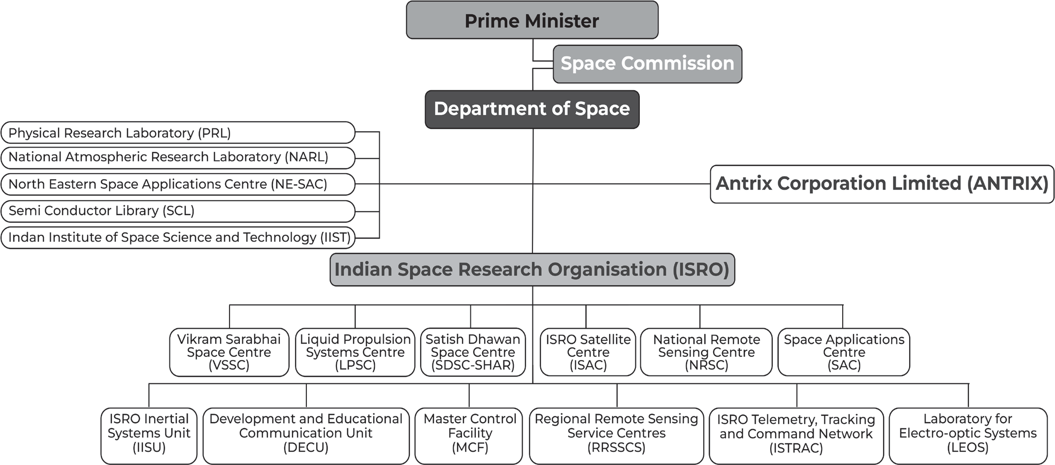
In June 1972, the Indian government formed the Department of Space (DOS), placed ISRO under DOS, and established the Space Commission. The Department of Space (DOS) is primarily in charge of advancing space science, technology, and applications in order to help the country become self- sufficient and grow economically. Towards this, DOS has evolved the following programmes:
Indian National Satellite (INSAT) programme for telecommunications, TV broadcasting, meteorology, developmental education, etc.
Remote Sensing programme for application of satellite imagery for various developmental purposes.
Indigenous capability for design and development of spacecraft and associated technologies for communications, resources survey and space sciences.
Design and development of launch vehicles with indigenous technology for access to space and orbiting INSAT, IRS spacecraft and space science missions.
•
Research and development in space sciences and technologies as well as application programme for national development.
The Space Commission in India formulates policies and oversees the implementation of the Indian space programme, promoting space science and technology for socio-economic benefit. The Department of Space (DOS) implements these programmes through various institutions, including Indian Space Research Organisation (ISRO), Physical Research Laboratory (PRL), National Atmospheric Research Laboratory (NARL), North Eastern-Space Applications Centre (NESAC) and Semi-Conductor Laboratory (SCL).
From its inception, the Indian space program has been built on three foundational pillars:
• The deployment of satellites for communication and remote sensing.
• The development of a space transportation system.
• The implementation of application programs designed to leverage space technology for various national requirements.
In 1967, the first Experimental Satellite Communication Earth Station (ESCES) was operationalized in Ahmedabad, serving as a training center for Indian and international scientists and engineers. ISRO aimed to establish a satellite system that could contribute to the national development by using foreign satellites in the initial stages. The first controlled experiment was the ‘KrishiDarshan’ TV program on agricultural information for farmers, which received good response.
The next step was the Satellite Instructional Television Experiment (SITE), which was hailed as the largest sociological experiment in the world, covering 2400 villages of six states and transmitting development-oriented programs using the American Technology Satellite (ATS-6). The credit of training 50,000 science teachers primary schools in one year goes to SITE.
The Satellite Telecommunication Experiments Project (STEP) was a joint project of ISRO-and Post and Telegraphs Department (P&T) using the Franco-German Symphonie satellite during 1977-79. STEP aimed to provide a system test of using geosynchronous satellites for domestic communications, enhance capabilities and experience in the design, manufacture, installation, operation and maintenance of various ground segment facilities and build up requisite indigenous competence for the proposed operational domestic satellite system, INSAT, for the country.
During this period, the first Indian spacecraft, ‘Aryabhata’, was developed and launched using a Soviet Launcher. The first launch vehicle, SLV-3, with a capability to place 40 kg in Low Earth Orbit (LEO) was developed, which had its first successful flight in 1980. The development of mult- istage rocket systems with appropriate control and guidance systems to orbit a satellite was a major landmark in the space programme.
During the operational phase in the 90s, major space infrastructure was created under two broad classes: communication, broadcasting, and meteorology through a multi-purpose Indian National Satellite system (INSAT) and the Indian Remote Sensing Satellite (IRS) system.
The IRS launched its first satellite in 1988, and the program continued to develop more specialized satellites, such as the Radar Imaging Satellite-1 (RISAT-1, launched in 2012) and the Satellite with Argos and Altika (SARAL, launched in 2013), a joint Indian-French mission that measures ocean wave heights. ISRO then created three more rockets: the Polar Satellite Launch Vehicle (PSLV) for putting satellites into polar orbit, the Geostationary Space Launch Vehicle (GSLV)
for putting satellites into geostationary orbit and a heavy- lift version of the GSLV known as the LVM3. These rockets launched communications and Earth-observation satellites, as well as the Chandrayaan lunar missions (Chandrayaan-1, 2008; Chandrayaan-2, 2019; Chandrayaan-3, 2023) and India’s first Mars mission, the Mars Orbiter Mission (2013). ISRO plans to put astronauts into orbit with the Gaganyaan spacecraft in 2025.
Space Centres and Agencies functioning in India under DOS
• ISRO Centres & Units
• Department of Space and ISRO HQ
• Human Space Flight Centre (HSFC)
• Indian Institute of Remote Sensing (IIRS)
• ISRO Inertial Systems Unit (IISU)
• ISRO Propulsion Complex (IPRC)
• ISRO Telemetry, Tracking and Command Network (ISTRAC)
• Laboratory for Electro-Optics Systems (LEOS)
• Liquid Propulsion Systems Centre (LPSC)
• Master Control Facility (MCF)
• National Remote Sensing Centre (NRSC)
• Satish Dhawan Space Centre (SDSC) SHAR
• Space Applications Centre (SAC)
• U R Rao Satellite Centre (URSC)
• Vikram Sarabhai Space Centre (VSSC)
• IN-SPACe
• CPSEs
• Antrix Corporation Limited
• NewSpace India Limited (NSIL)
• Autonomous bodies
• Indian Institute of Space Science and Technology (IIST)
• National Atmospheric Research Laboratory (NARL)
• North Eastern-Space Applications Centre (NE-SAC)
• Physical Research Laboratory (PRL)

Indian Space Research Organization (ISRO), Bangalore
The Indian Space Research Organisation (ISRO) is the national space agency of India, responsible for space- based operations, exploration, international cooperation, and technology development. It is one of six global space agencies with full launch capabilities, cryogenic engines, extraterrestrial missions and a large fleet of artificial satellites. ISRO is one of the four government space agencies to have soft landing (uncrewed) capabilities. In 1969, ISRO replaced INCOSPAR which was established in 1962 by Jawaharlal Nehru and Dr. Vikram Sarabhai. INCOSPAR grew and became ISRO in 1969 and was incorporated into the Department of Atomic Energy (DAE) in 1972. In 1972, India established the Space Commission and the Department of Space (DoS), establishing ISRO, which institutionalized space research activities in the country. The DoS now manages ISRO and other Indian institutions in astronomy and space technology.
VikramSarabhaiSpaceCentre(VSSC),Thiruvananthapuram
Vikram Sarabhai Space Centre (VSSC) at Thiruvananthapuram is the major centre of ISRO, where the design and development activities of satellite launch vehicles and sounding rockets are carried out and made ready for launch operations. The centre focuses on various technologies such as launch vehicle design, propellants, solid propulsion technology, aerodynamics, avionics, polymers, composites, guidance, control, simulation, computer and information, mechanical engineering, aerospace mechanisms, vehicle integration and testing, space ordnance, chemicals, and materials. The centre ensures systems reliability and quality assurance in all engineering and operations aspects. The Space Physics Laboratory at VSSC conducts research in atmospheric science and related space science activities. The Ammonium Perchlorate Experimental Plant (APEP) in Kerala is part of VSSC. Major programs at VSSC include launch vehicle projects for Polar Satellite Launch Vehicles (PSLV), Geosynchronous Satellite Launch Vehicles (GSLV
Mark II and Mark III), Rohini Sounding Rockets, Space- capsule Recovery Experiments, Reusable Launch Vehicles,
and Air Breathing Propulsion for Advanced Reusable Launch Vehicles.
Satish Dhawan Space Centre (SDSC) SHAR, Sriharikota
Satish Dhawan Space Centre (SDSC) SHAR with two launch pads is the main launch centre of ISRO located at 100 km north of Chennai. SDSC SHAR has the necessary infrastructure for launching satellite into low earth orbit, polar orbit and geostationary transfer orbit. The launch complexes provide complete support for vehicle assembly, fuelling, checkout and launch operations. Apart from these, it has facilities for launching sounding rockets meant for studying the earth’s atmosphere. Achievements include establishment of launch complexes for Sounding rockets, SLV- 3, ASLV and PSLV. Launch complex augmented for GSLV.
Liquid Propulsion Systems Centre (LPSC), Thiruvananthapuram / Karnataka
The LPSC takes care of design development, testing, and implementation liquid propulsion packages. The production and testing of liquid stages and liquid engines for launch vehicles and satellites take place here. LPSC, Bangalore on the other hand is responsible for producing precision transducers.
U R Rao Satellite Centre, Bangalore
It is the lead centre of the Indian Space Research Organisation (ISRO) responsible for design, development, assembly & integration of communication, navigation, remote sensing, scientific and small satellite missions. URSC’s specialized teams have developed over 90 advanced satellites for various applications, including telecommunications, telemedicine, navigation, weather forecasting and disaster warning. They aim to expand space technology benefits to society by creating cost-effective infrastructure.
Space Applications Centre (SAC), Ahmedabad
The Space Applications Centre (SAC) is a major center of the Indian Space Research Organisation (ISRO) that focuses on various disciplines such as payload design, societal applications, capacity building and space sciences. It develops communication, navigation, earth and planetary observation payloads, meteorological payloads, data processing and ground systems. SAC operates Ahmedabad and Delhi Earth Stations and hosts training programs under the UN-affiliated Centre for Space Science & Technology Education in Asia and the Pacific (CSSTEAP).
National Remote Sensing Centre (NRSC), Hyderabad
The National Remote Sensing Centre (NRSC) handles satellite data acquisition, processing, dissemination, aerial remote sensing, and disaster management support. The centre also collaborates with users on remote sensing application projects.
ISRO Telemetry Tracking and Command Network (ISTRAC), Bangalore
ISRO Telemetry Tracking and Command Network (ISTRAC) provides space operation services for launch vehicle, low earth orbiting spacecraft and deep space missions. It also develops RADAR systems for tracking and atmospheric applications and establishes a Ground Segment Network for the Indian Regional Navigation Satellite System. ISRO has established a network of ground stations to provide Telemetry, Tracking, and Command (TTC) support for satellite and launch vehicle missions, with facilities in Bangalore, Lucknow, SHAR, Thiruvananthapuram, Port Blair Island, Brunei, Biak, and Mauritius. The Indian Deep Space Network (IDSN) forms the ground segment for India’s Chandrayaan-1 mission.
Master Control Facility (MCF), Hassan & Bhopal
The Master Control Facility (MCF) in Karnataka and Madhya Pradesh oversees ISRO’s geo-stationary satellites, performing operations like initial orbit raising, in-orbit payload testing, and on-orbit operations. It also handles special operations like eclipse management and station-keeping manoeuvres. MCF collaborates with user agencies to optimize satellite payload utilization and minimize service disruptions.
ISRO Propulsion Complex (IPRC), Mahendragiri
ISRO Propulsion Complex (IPRC), Mahendragiri, is a state- of-the-art facility for ISRO space research. Previously known as LPSC, Mahendragiri, it was elevated as IPRC on February 1, 2014, due to future growth in the nation’s space program and expansion at the site.
ISRO Inertial Systems Unit (IISU), Thiruvananthapuram
ISRO Inertial Systems Unit (IISU) in Thiruvananthapuram designs and develops inertial systems for launch vehicles and spacecraft programs. Major systems include navigation systems, attitude reference systems, rate gyro packages, and accelerometer packages. IISU also designs actuators and mechanisms for spacecraft. It engages in continuous research and development to improve cost-effective, reliable and realisable systems.
Indian Institute of Remote Sensing (IIRS), Dehradun
It aims to build capacity in Remote Sensing and Geo- informatics through postgraduate education and training programs. It supports the Centre for Space Science and Technology Education in Asia and the Pacific (CSSTE-AP) and caters to various user groups.
SPACE BASED PROGRAMME
YUVIKA
• Indian Space Research Organisation is organising a special programme for School Children called “Young Scientist Programme” “YUva VIgyani KAryakram”, YUVIKA, to impart basic knowledge on Space Technology, Space Science and Space Applications to the younger students in emerging trends in space science and technology amongst the youngsters, who are the future building blocks of our nation.
• ISRO has chalked out this programme to “Catch them young”. The programme is also expected to encourage more students to pursue in Science, Technology, Engineering and Mathematics (STEM) based research /career.
• It was a two-week residential programme for the high school students.
• The students were given exposure to space science, technology and applications through classroom lectures, hands-on activities such as model rocketry, sky gazing, robotic coding/experiments, CANSAT experiments, drone demonstrations, DIY kits assembly, facility visits and interaction with eminent scientists etc.
Extracurricular activities like yoga & meditation, sports, cultural activities and local sight tours etc. were also organised as part of the residential programme.
Antrix Corporation
Antrix Corporation Limited (ACL), a government-owned company, was established in 1992 as a marketing arm of ISRO to promote and commercialize space products, technical consultancy services, and transfer of ISRO-developed technologies. The company aims to develop space-related industrial capabilities in India. As the commercial and marketing arm of ISRO, Antrix provides space products and services to international customers worldwide. It offers hardware and software for various applications, including communications, earth observation, and scientific missions. It also provides space-related services such as remote sensing data, transponder lease, launch services, mission support services, and consultancy and training services
In-space
IN-SPACe
Indian Government has created Indian National Space Promotion and Authorization Centre (INSPACe) to boost private sector participation in entire range of space activities.
About IN-SPACe
It is the new entity of the Department of Space which will have its own chairperson and board.
It will regulate and promote building of routine satellites, rockets and commercial launch services through Indian industry and startups.
It will have its own directorates for technical, legal, safety and security, monitoring and activities promotion.
It will act as an interface between ISRO and private parties, and assess how best to utilise India’s space resources and increase space-based activities
It will function autonomously and parallel to ISRO. ISRO will remain the basic body that decides what missions are to be undertaken but INSPACe will help fill the gaps
New Space India Limited
New Space India Limited (NSIL)
• It was founded in 2019, by Department of Space (DoS) to bridge gap between ISRO and private sector and facilitates transfer of ISRO technologies to industry
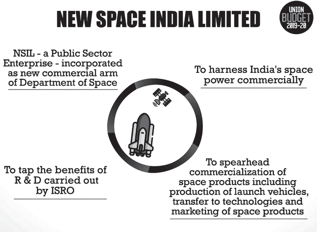
• It is a wholly-owned Government of India company, under the administrative control of DoS
• It will not replace ANTRIX, a private limited company owned by Government of India in 1992 as a Marketing arm of ISRO
• It is a Central PSU under DoS
• Antrix will handle ISRO’s commercial deals for satellites and launch vehicles with foreign customers
• NSIL will deal with capacity building of local industry for space manufacturing
• Vision:
• build launch vehicle
• providing launch services, build satellites
• providing space-based services
• technology transfers
space-related products
services to global customers
spur the growth of Indian Industry in undertaking technologically challenging space-related activities
• NSIL’s main purpose is to market the technologies developed by ISRO and bring it more clients that need space-based services
• That role, incidentally, was already being performed by Antrix Corporation, another PSU working under the Department of Space, and which still exists
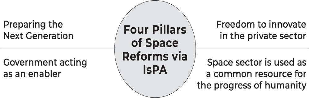
Indian Space Association
Indian Space Association
The industry association will act as an independent and a “single-window” agency for enabling the opening up of the space sector to start-ups and the private sector
ISpA will also work towards building global linkages for the Indian space industry to bring in critical technology and investments into the country to create more high- skill jobs
The current global space economy is estimated at US$
360 billion, with India accounting for ~2% (US$ 7 billion)
In the global space market, rocket and satellite launch services, an area in which ISRO specialises, amount to only 5% share whereas satellite-based services and ground-based systems account for the remaining 95%.
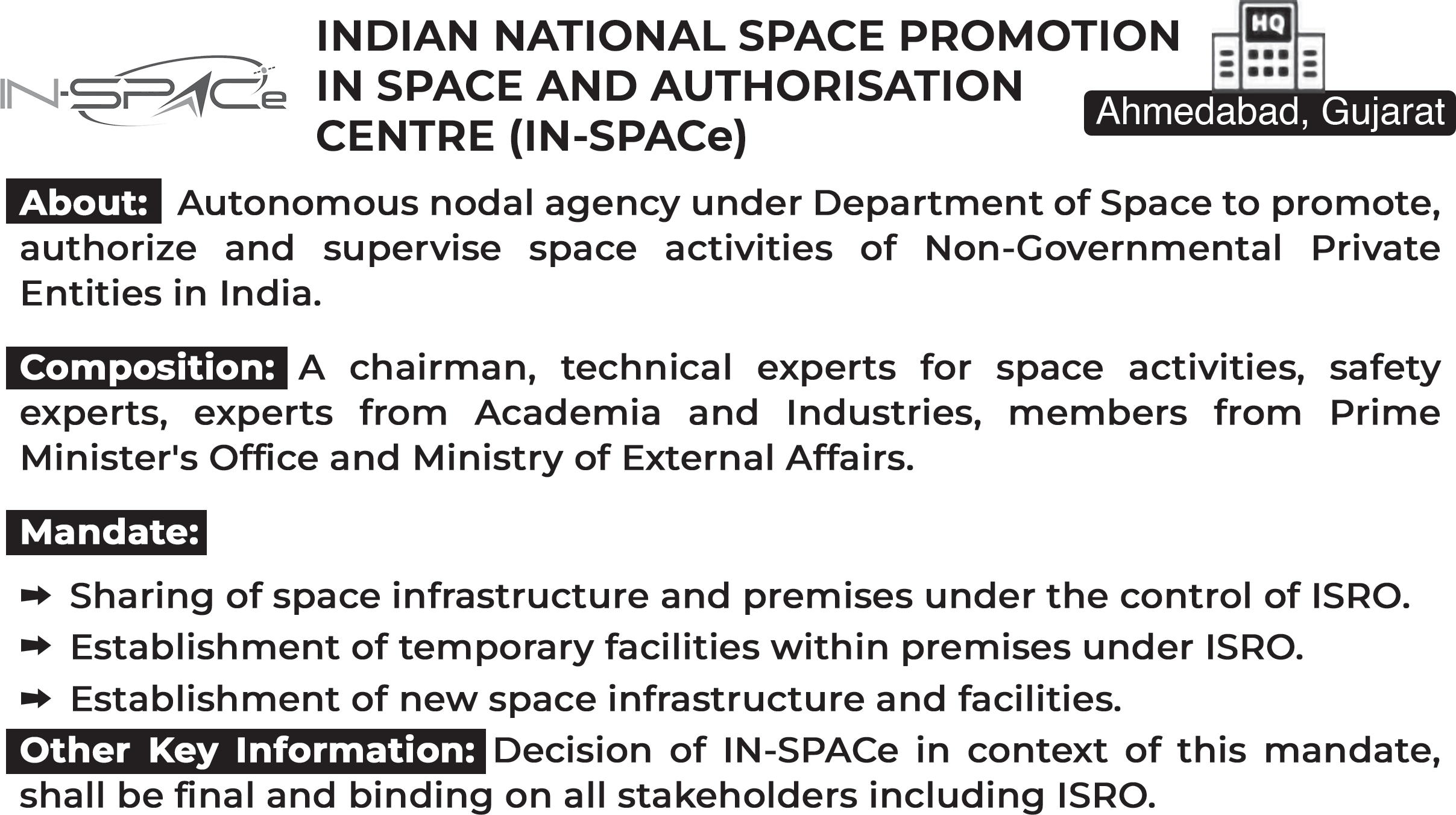
Several private companies are developing plans to take paying customers to space on a regular basis leading to a rapid growth in space tourism industry.
Key Differences in aims and objectives of various organizations:
• Antrix will handle ISRO’s commercial deals for satellites and launch vehicles with foreign customers.
• NSIL will deal with capacity building of local industry for space manufacturing
• The main objective of NSIL is to scale up industry participation in Indian space programmes in comparison to IN-SPACe which gives emphasis on the participation of the private sector
• However, NSIL is also doing commercial deals.

Space Travel and Tourism
Space Travel and Tourism
Space tourism, usually known as recreational space travel, refers to travel on established government-owned vehicles such as the Russian Soyuz and the International Space Station (ISS), as well as vehicles operated by private businesses. Since the voyage of the world’s first space tourist, American businessman Dennis Tito, on April 28, 2001, space tourism has grown in popularity as more suborbital and orbital tourism options become available.
Orbital space tourism
Space tourism began in the late 1990s with a deal between Russian company MirCorp and American company Space Adventures Ltd. Tito became the first paying passenger for MirCorp’s aging space station, Mir. However, the mission was deorbited before Tito could make his trip, and the mission was diverted to the International Space Station (ISS). Tito paid $20 million for his Soyuz TM-32 flight, spending seven days on board the ISS and becoming the world’s first space tourist. The term “spaceflight participant” has been used to distinguish commercial space travellers from career astronauts since Tito’s flight. Orbital space tourism continued to grow, with South African computer millionaire Mark
Shuttleworth and American businessman Gregory Olsen visiting the ISS in 2002 and 2005 respectively. Iranian- born American entrepreneur Anousheh Ansari became the fourth spaceflight participant and the first female fee-paying space traveller in September 2006. American spaceflight corporation SpaceX has allowed its Crew Dragon spacecraft to be chartered for orbital flights.
Suborbital Space Tourism
The orbital space tourism industry gained significant media attention following Tito’s flight, but other companies were also working to make it profitable by developing suborbital vehicles for passengers. They were competing for the Ansari X Prize, a $10 million reward offered by the X Prize Foundation to the first nongovernmental organization to launch a reusable crewed spacecraft into space twice within two weeks. SpaceShipOne, funded by Virgin Galactic and designed by American engineer Burt Rutan of Scaled Composites, won the X Prize in 2004, marking a new era of commercial crewed spaceflight and space tourism.
In 2004,the U.S. Commercial Space Launch Amendments Act (CSLAA) provided guidelines for regulating the safety of commercial human spaceflight in the United States under the auspices of the Federal Aviation Administration (FAA). The CSLAA requires space tourism operators to inform participants in writing about the risks of launch and re-entry, as well as the safety record of the launch vehicle. Spaceflight participants must provide informed consent to participate in launch and re-entry.
Blue Origin, a privately funded aerospace company, developed its New Shepard spacecraft in Texas, which took off and landed vertically, unlike SpaceShipTwo’s mother- ship deployment. The first flight of New Shepard took place on July 20, 2021, with a crew of Bezos, his brother Mark, Wally Funk and Oliver Daemen. As the space tourism industry evolves, the ranks of spaceflight participants will grow, leading to lunar excursions and trips to Mars and beyond.

Facts to remember:
Space tourism is space travel for recreational, leisure or business purposes
There are several different types of space tourism, including orbital, suborbital and lunar space tourism.
To date, orbital space tourism has been performed only by the Russian Aviation and Space Agency- ROSCOSMOS
Several private spaceflight companies are now working towards developing suborbital space tourism vehicles to take paying customers to space
No international space law has defined space tourists
Existing space treaties such as Outer Space Treaty, Rescue Agreement etc. are only applicable to astronauts, envoys of mankind, or personnel of a spacecraft
To send a vehicle to space, it is compulsory for the national and international space law to authorize it according to Article VI of the Outer Space Treaty. However, there is lack of clarity on authorization of space travel with tourists aboard
According to the Fédération Aéronautique Internationale (world governing body for aeronautic and astronautic records), space starts at an altitude of 100 km (62 miles) above the surface of the earth
This is the Karman line where atmospheric lift no longer supports a flying object and the object would need to reach orbital velocity or risk falling back to Earth
Space travel is referred to as any flight operation that takes one or more passengers beyond the altitude of 100 km and thus into space
The main difference between orbital and suborbital flight is the speed at which a vehicle is traveling
An orbital spacecraft must achieve orbital velocity i.e., the speed that an object must maintain to remain in orbit around a planet.
To orbit 125 miles (200 kilometres) above Earth for instance, a spacecraft must travel at a screaming 17,400 mph (28,000 km/h)
Suborbital flight, in contrast, requires much lower speeds and doesn’t have the power to achieve orbit. Instead, it will fly up to a certain height that depends on its speed, and then come back down once its engines are shut off
At the top of their flight arc in a suborbital flight, when the object is falling back toward Earth, passengers achieve a few minutes of weightlessness under zero gravity.
Space Exploration
SPACE EXPLORATION
Chandrayaan 1
Chandrayaan-1, India’s first mission to Moon, was launched successfully on October 22, 2008 from SDSC SHAR, Sriharikota. The spacecraft was orbiting around the Moon
at a height of 100 km from the lunar surface for chemical, mineralogical and photo-geologic mapping of the Moon. The spacecraft carried 11 scientific instruments built in India, USA, UK, Germany, Sweden and Bulgaria.
After the successful completion of all the major mission objectives, the orbit has been raised to 200 km during May 2009. The satellite made more than 3400 orbits around the moon and the mission was concluded when the communication with the spacecraft was lost on August 29, 2009.
Facts to remember:
• Orbiter only
• Had to be stopped due to battery issues
• Found loss of water are on surface of moon, confirmed by NASA
• Found landing site of apollo mission
• Carried instruments from Multiple Countries
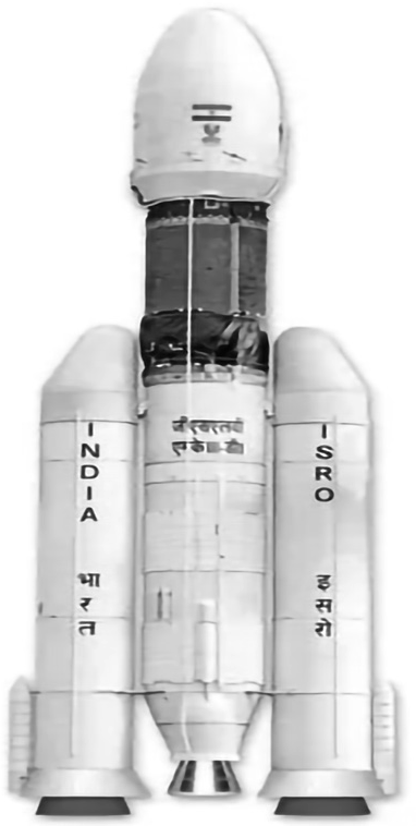
Chandrayaan 2
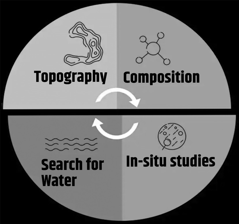
Chandrayaan-2 mission was a highly complex mission, which represents a significant technological leap compared to the previous missions of ISRO, which brought together an Orbiter, Lander and Rover with the goal of exploring
south pole of the Moon. It was a unique mission which aims at studying not just one area of the Moon but all the areas combining the exosphere, the surface as well as the sub- surface of the moon in a single mission.
Why did we go to the Moon?
The Moon is the closest cosmic body at which space discovery can be attempted and documented. It is also a promising test bed to demonstrate technologies required for deep-space missions. Chandrayaan-2 aims for enhancing our understanding of the Moon, stimulate the advancement of technology, promote global alliances and inspire a future generation of explorers and scientists.
What are the scientific objectives of Chandrayaan 2? Why was the Lunar South Pole targeted for exploration?
Moon provides the best linkage to Earth’s early history. It offers an undisturbed historical record of the inner Solar system environment. Though there are a few mature models, further explanations were needed to understand the origin of the Moon. Extensive mapping of lunar surface to study variations in lunar surface were essential to trace back the origin and evolution of the Moon. Evidence for water molecules discovered by Chandrayaan-1, required further studies on the extent of water molecule distribution on the surface, below the surface and in the tenuous lunar exosphere to address the origin of water on Moon.
The Lunar South pole is especially interesting because of the lunar surface area that remains in shadow is much larger
Launcher
than that at the North Pole. There could be a possibility of presence of water in permanently shadowed areas around it. In addition, South Pole region has craters that are cold traps and contain a fossil record of the early Solar System.
After the injection of Chandrayaan-2, a series of manoeuvres were carried out to raise its orbit and on August 14, 2019, following Trans Lunar Insertion (TLI) manoeuvre, the spacecraft escaped from orbiting the earth and followed a path that took it to the vicinity of the Moon. On August 20, 2019, Chandrayaan-2 was successfully inserted into lunar orbit. While orbiting the moon in a 100 km higher polar orbit, on September 02, 2019, Vikram Lander was separated from the Orbiter in preparation for landing. Subsequently, two de-orbit manoeuvres were performed on Vikram Lander so as to change its orbit and begin circling the moon in a 100 km x 35 km orbit. Vikram Lander descent was as planned and normal performance was observed up to an altitude of
km. Subsequently communication from lander to the ground stations was lost.
The Orbiter placed in its intended orbit around the Moon will enrich our understanding of the moon’s evolution and mapping of the minerals and water molecules in Polar regions, using its eight state-of-the-art scientific instruments. The Orbiter camera is the highest resolution camera (0.3 m) in any lunar mission so far and will provide high resolution images which will be immensely useful to the global scientific community. The precise launch and mission management has ensured a long life of almost seven years instead of the planned one year.
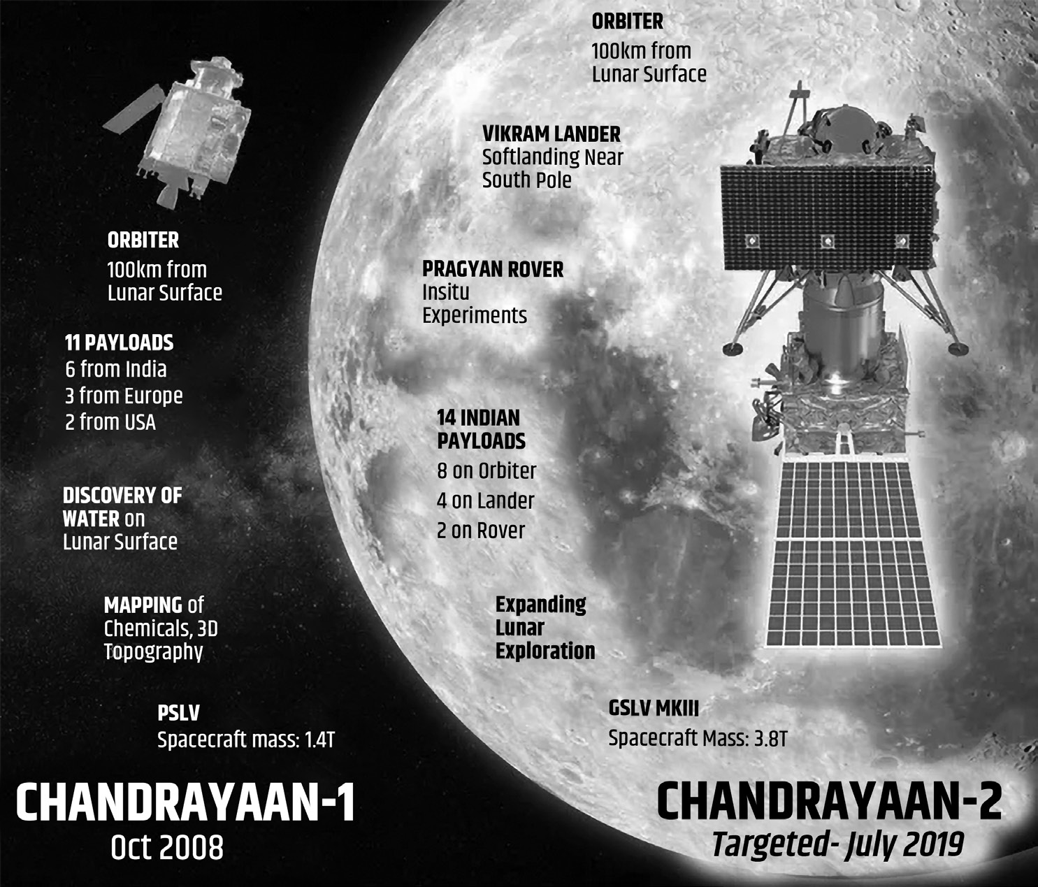
Geosynchronous Satellite Launch Vehicle Mark-III (GSLV Mk-III)- The GSLV Mk-III carried Chandrayaan 2 to its designated orbit. This three-stage vehicle is India’s most powerful launcher to date and is capable of launching 4-ton class of satellites to the Geosynchronous Transfer Orbit (GTO).
Its components are:
S200 solid rocket boosters
L110 liquid stage
C25 upper stage
Facts to remember about the Chandrayaan 2:
Orbiter
Vikram Lander
Pragyaan Rover
Assistance from Russia and France
Orbiter was successful, but lander and rover could not reach the surface of the moon.
Chandrayaan 3
Chandrayaan-3, a follow-on mission to Chandrayaan-2, was launched using LVM3 (Geosynchronous Satellite Launch Vehicle Mk III).
Chandrayaan-2 was only a partial success, because its lander Vikram and rover Pragyaan, crashed on Moon’s surface.
•
The landing site of Chandrayaan-3 is more or less the same as Chandrayaan-2: near the south pole of the moon at 70 degrees latitude.
• Chandrayaan-3 is the world’s first mission to soft-land near the lunar south pole.
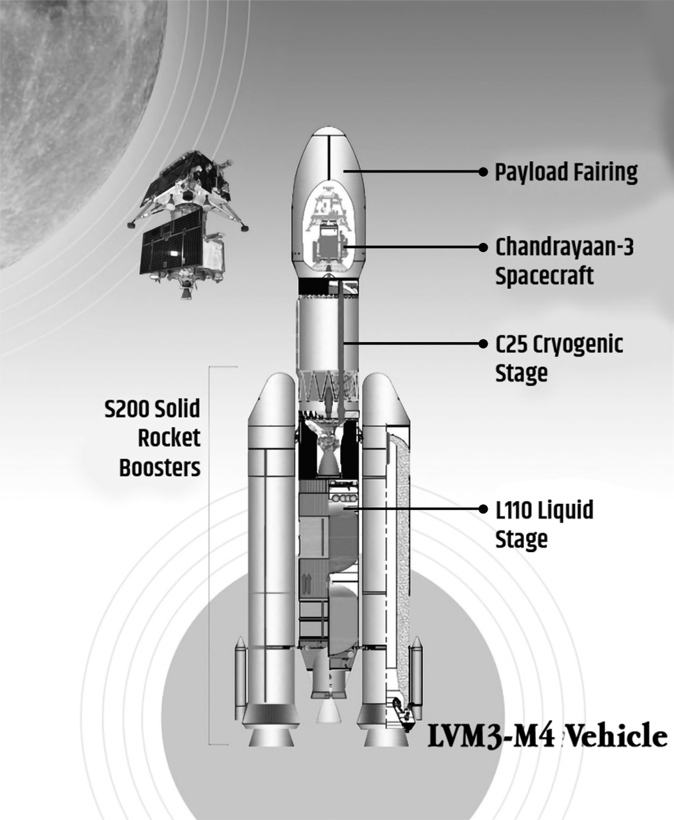
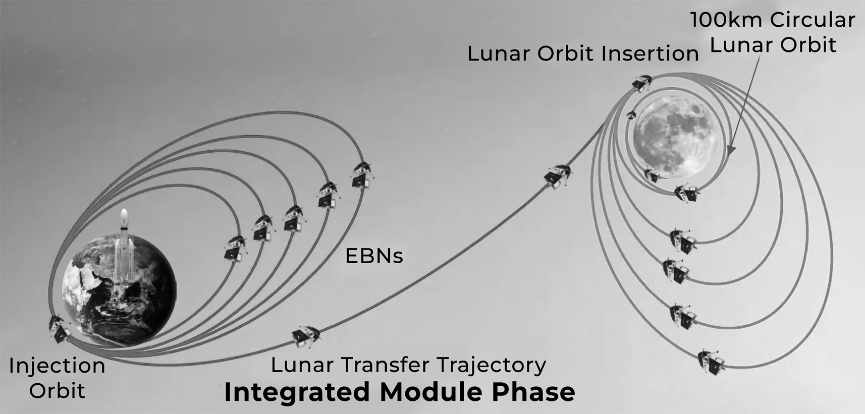
Moon’s south pole has certain advantages including:
• Its craters have been untouched by sunlight for billions of years — offering an undisturbed record of the solar system’s origins.
• Its permanently shadowed craters are estimated to hold enough water that could potentially be used for future missions.
• Its positional advantages make it a suitable pit stop for future space exploration.
•
It has traces of hydrogen, ammonia, methane, sodium, mercury and silver making it an untapped source of essential resources.
• All previous spacecraft to have landed on Moon have landed in the equatorial region.
• It is easier and safer to land near the equator.
• Terrain and temperature are more hospitable and conducive for a long and sustained operation of instruments.
• Sunlight is present in abundance, at least on the side facing the earth
Launch Vehicle Mk III
• LVM3 is a three-stage vehicle with two solid strap-on motors (S200), one liquid core stage (L110) and a high- thrust cryogenic upper stage (C25).
• It has a carrying capacity of 8 tonnes to Low Earth Orbit and 4 tonnes to Geosynchronous Transfer Orbit.
• LVM3 is the operational heavy-lift launch vehicle of ISRO and has a spectacular pedigree of completing 6 consecutive successful missions. This is the 4th operational flight of LV
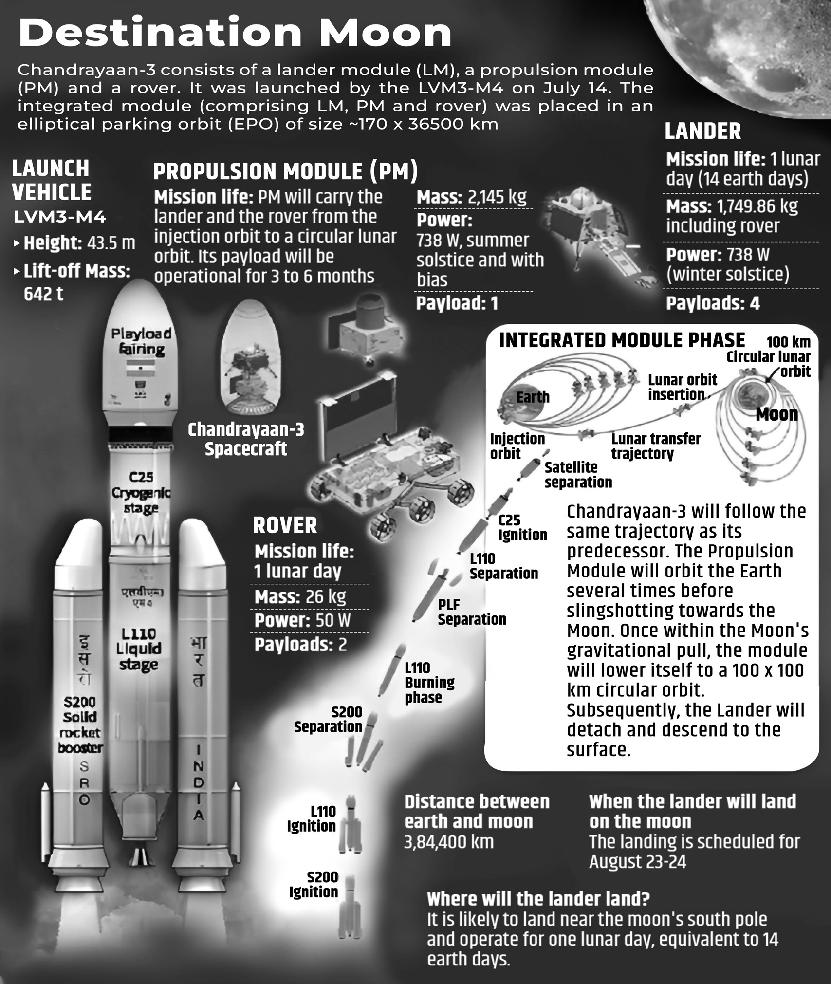
Objectives of Launcher
• Demonstrate a Safe and Soft Landing on Lunar Surface
• Demonstrate the rover moving on the moon and conduct in-situ scientific experiments.
• Data from Chandrayaan-3 will be useful for future Artemis human landings.
• Chandrayaan-3 consists of an indigenous propulsion module, a lander module and a rover to develop and demonstrate new technologies required for interplanetary missions
• Lander and rover will collect invaluable data for scientific research on the lunar surface for 14 Earth days (a single day on the moon).
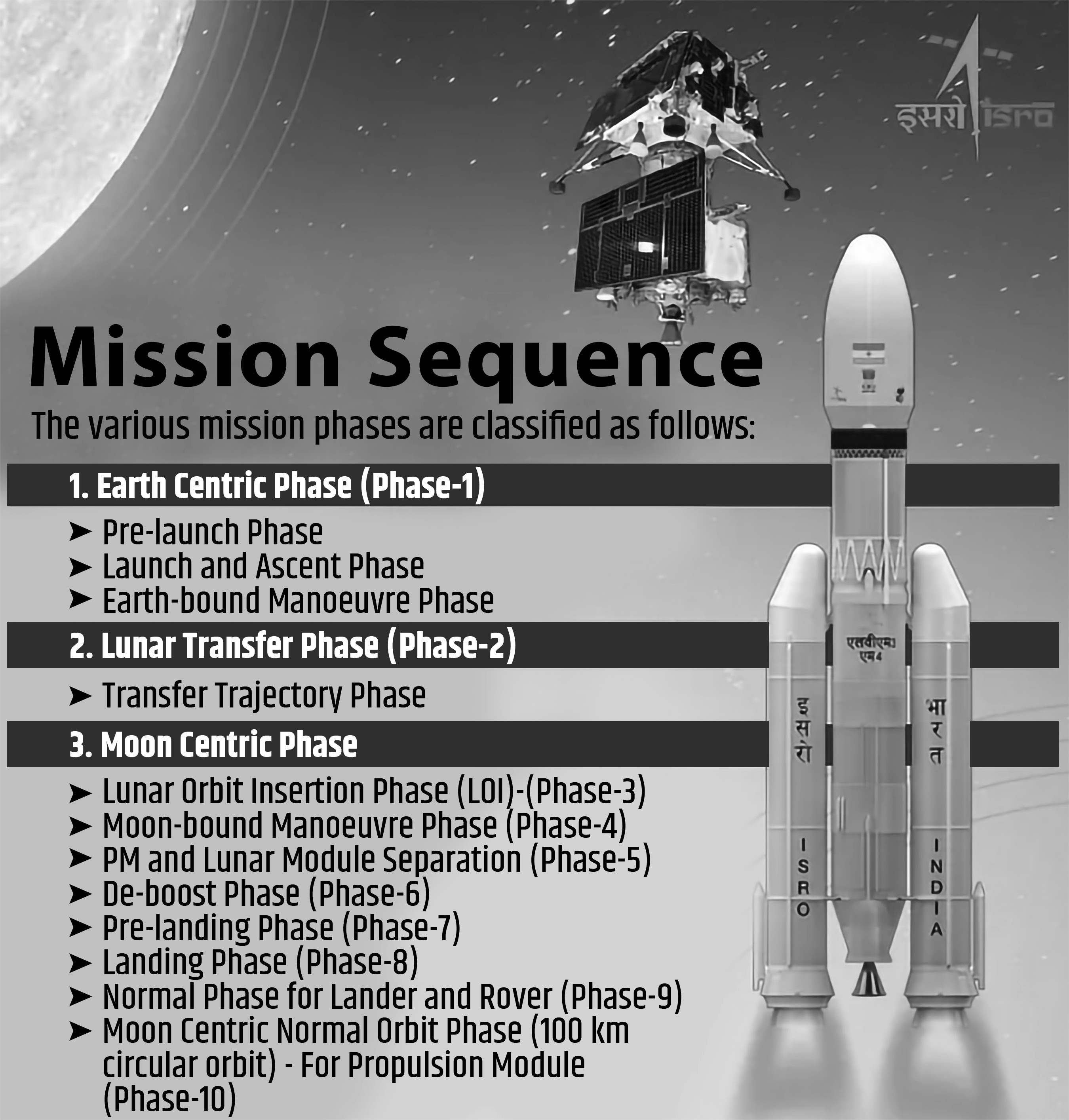
• A successful soft landing made India the 4th country, after US, Russia and China, to achieve the feat.
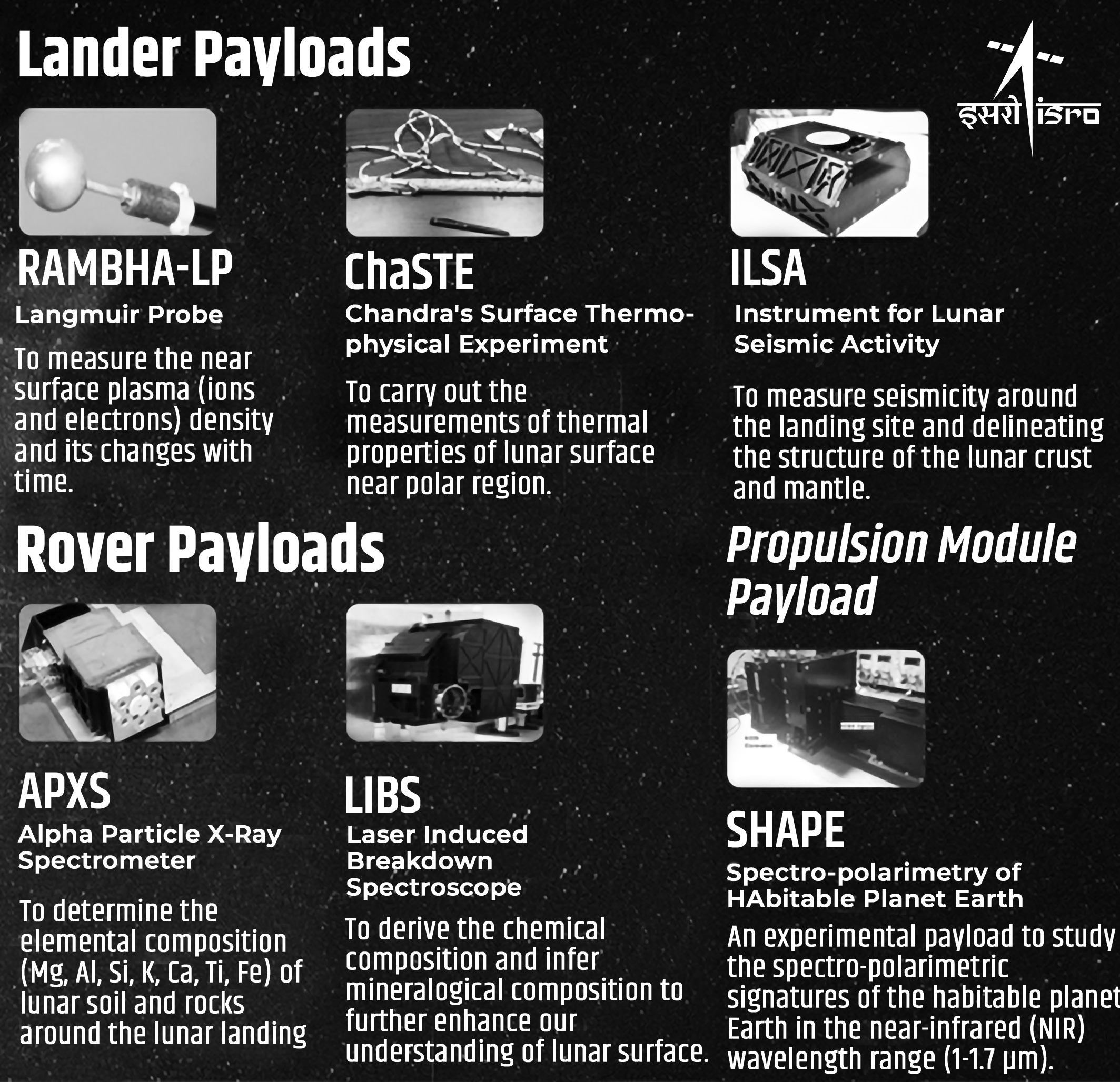
Mars Orbitor Mission 1 (MOM 1) or the Mangalyaan
Mars Orbiter Mission (MOM), India’s first interplanetary mission to planet Mars was launched onboard PSLV-C25 on November 05, 2013. ISRO has become the fourth space agency to successfully send a spacecraft to Mars orbit. Though the designed mission life is 6 months, MOM completed 7 years in its orbit on Sept 24, 2021.
Mission Objectives
The objectives of this mission are primarily technological and include design, realisation and launch of a Mars Orbiter spacecraft capable of operating with sufficient autonomy during the journey phase; Mars orbit insertion/capture and in-orbit phase around Mars. MOM carries five scientific payloads to study the Martian surface features, morphology, mineralogy and Martian atmosphere.
Scientific payloads
Mars continues to be an object of keen interest to scientists in the context of planetary evolution and extra-terrestrial life. Based on our understanding of Mars, which was thought to be probably a warm and wet planet earlier, is now seen to be dry with
a thin atmosphere. How this evolution has taken place is still a topic of research. In this backdrop, the Indian Mars Orbiter Mission carried the following five scientific payloads:
Mars Colour Camera (MCC)
• The Mars Colour Camera is a versatile and multi-purpose snap shot camera with R-G-B Bayer pattern to map various morphological features on Mars and return visual images of Mars and its environs. Besides providing context information for other payloads, MCC is also expected to observe and help in furthering our understanding of events like dust storms, dust devils etc. that are known to occur in Mars. The highly elliptical orbit of the current mission allows imaging of localized scenes at high spatial resolution as well as provides a synoptic view of the full globe. This payload is developed by Space Application Centre Ahmedabad.
• The main objective of the Mars Colour camera therefore is:
To map various morphological features on Mars with varying resolution and scales in the elliptical orbit.
To provide context information for the other science payloads.
Thermal Infrared Imaging Spectrometer (TIS)- The Thermal Infrared Imaging Spectrometer is a grating- based spectrometer which will measure the thermal emission from Martian surface. The data acquired by TIS will be processed and analysed in order to:
• Map temperature of the Martian surface
• Study the composition and mineralogy of Mars
• This spectrometer operates in the thermal infrared (TIR) region (7 micron to 13 micron). TIS has been configured with an un-cooled micro-bolometer array that saves significantly in terms of weight and power when compared to a cooled IR detector. This payload is developed by Space Applications Centre, Ahmedabad
Methane Sensor for Mars (MSM)- The Methane Sensor for Mars (MSM) is a differential radiometer based on Fabry-Perot Etalon filters operating in the short-wave infrared (SWIR) region. It measures solar radiance in two SWIR channels. There is absorption by CH4 in the first channel (methane channel) whereas no absorption in the second spectral channel (reference channel). So the differential signal gives a measure of column amount of CH4. It can measure CH4 concentration in the Martian atmosphere with few parts-per-billion accuracy. By scanning the scene from apareon, MSM can map the spatial distribution of methane. The temporal and spatial variation of methane derived from MSM data may provide some insight regarding its origin; whether it is biogenic or abiogenic. This payload is developed by Space Application Centre Ahmedabad.
Mars Exospheric Neutral Composition Analyser (MENCA)
Lyman Alpha Photometer (LAP)
Specifications of the mission
• Highly elliptical orbit geometry of MOM enables its Camera (MCC) to take snap shots of Full disc of Mars at its farthest point and finer details from closest point.
• First time observation of the far side of Deimos, one of the moons of Mars.
Achievements
• The Mars Colour Camera, one of the scientific payloads onboard MOM, has produced 1100+ images so far and published a Mars Atlas.
• Published more than 35 research papers in peer-reviewed journals.
• India’s ability to successfully realize the complex mission to Mars in its first attempt, in a cost-effective (Rupees 450 Cr) has captured the world attention and has propelled India’s image as a credible space fairing nation to greater heights. This capability could pave the way for greater opportunities for Space Commerce including launch services and marketing of Satellite Imageries.
• Mars Orbiter Mission is a mission of national pride which has attracted the attention of students, general public, media and international science/ technical community. Importantly, Mars Orbiter Mission has created enthusiasm among the younger generation in the country, provoked their curiosity to understand and discuss space related techniques and is maintaining the tempo throughout the mission.
Major results
• The solar coronal dynamics during the post-maxima phase of the solar cycle 24 using S -band radio signals from the MOM (MNRAS, 2022)
• Enhanced escape of Martian atmosphere during global dust storm (JGR-Planets, 2020)
• MENCA detected ‘hot’ (suprathermal – more energetic compared to thermal) Argon in the exosphere of Mars (GRL, 2017). Mars was at perihelion during this observation.
• Mars Exospheric Neutral Composition Analyser (MENCA) observations have shown for the first time that the abundance of Oxygen exceeds that of Carbon-Dioxide at an altitude of ~270 ±10 km, during the perihelion evening hours (GRL, 2016).
• Atmospheric optical depth (AOD) was estimated through Mars Colour Camera (MCC) observations and the studies reported the presence of lee-wave clouds above the southern wall of Valles Marineris (Icarus, 2015)
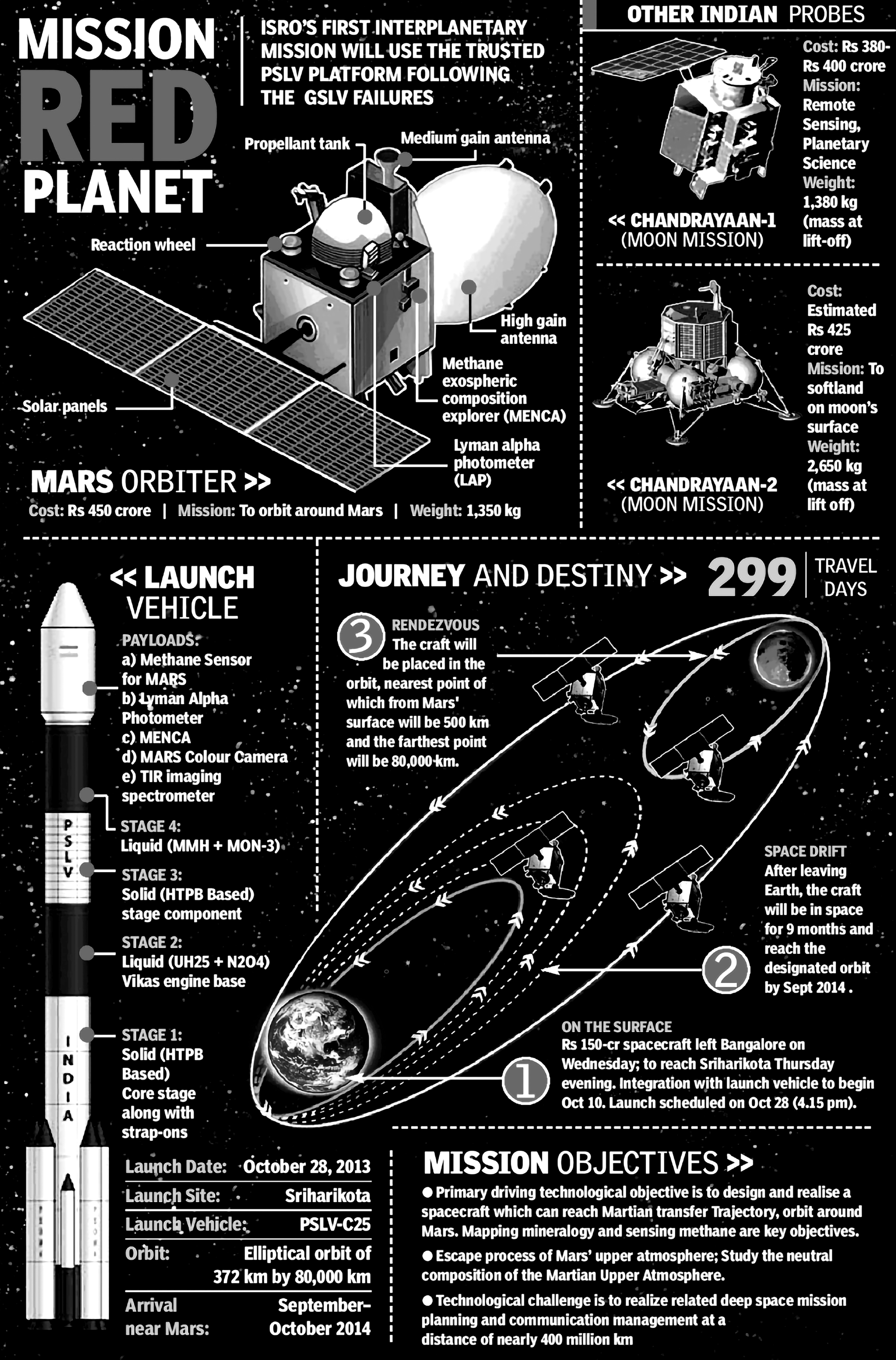
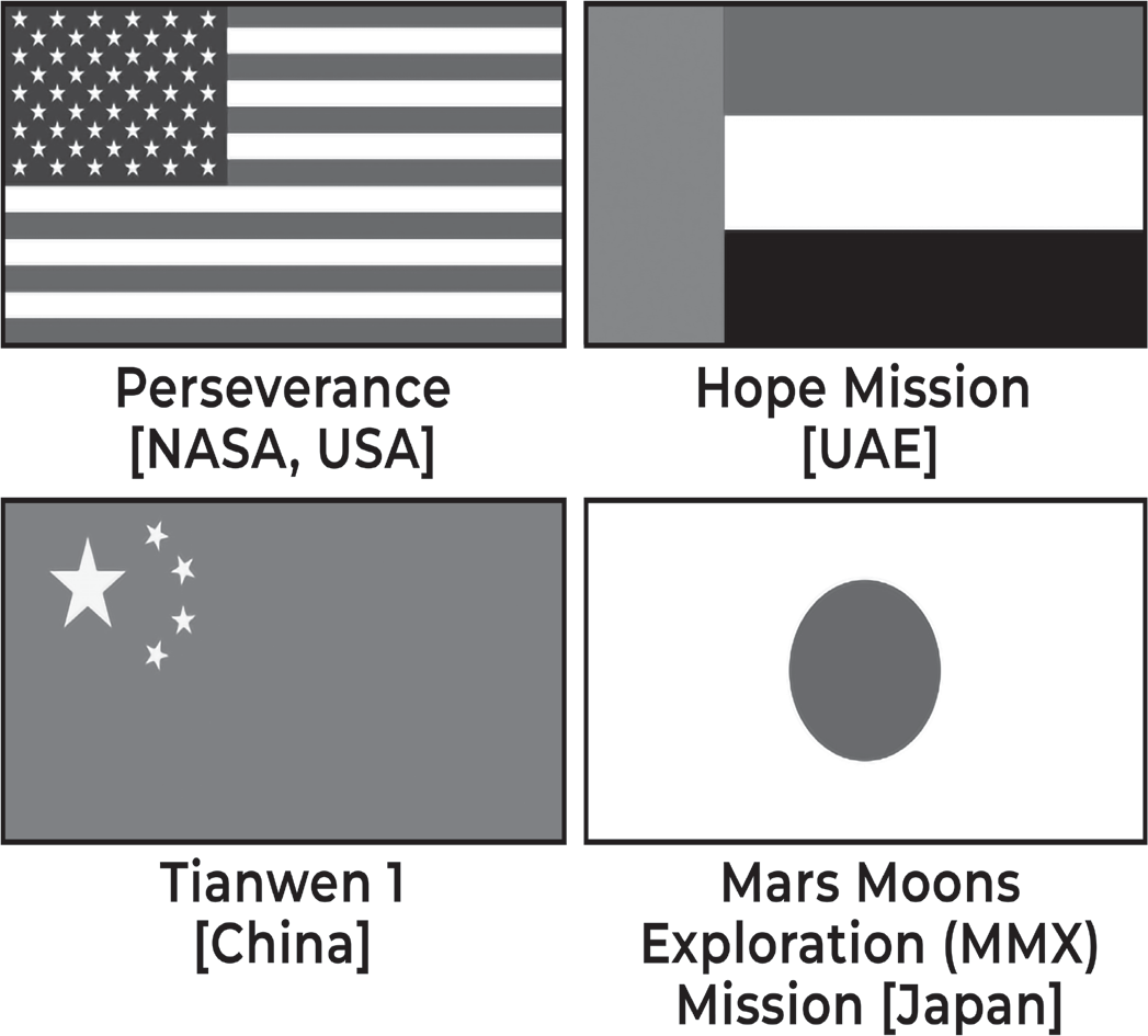
Perseverance by NASA
• Perseverance rover mission is part of NASA’s Mars Exploration Program, a long-term effort of robotic exploration of Mars
• Recently, it placed a titanium tube containing a rock sample on the surface of Mars.
• Igneous rock sample was collected from Mars Jezero Crater called South Séítah
• Samples are being placed at a location called “Three Forks,” first such sample depot on another world
• Depot will serve as a backup if Perseverance can’t deliver its samples and subsequent NASA missions would
• Recently, it also captured the solar eclipse on Mars featuring Phobos, one of Mars’ two moons (other is Deimos)
• In a related news, Mars Oxygen In-Situ Resource Utilization Experiment (MOXIE) has produced oxygen at Mars with components from the planet’s atmosphere
• MOXIE was sent (by Massachusetts Institute of Technology) with NASA’s Perseverance rover
AstroSat
AstroSat is the first dedicated Indian astronomy mission aimed at studying celestial sources in X-ray, optical and UV spectral bands simultaneously. The payloads cover the energy bands of Ultraviolet (Near and Far), limited optical and X-ray regime (0.3 keV to 100keV). One of the unique features of AstroSat mission is that it enables the simultaneous multi- wavelength observations of various astronomical objects with a single satellite.
AstroSat with a lift-off mass of 1515 kg was launched on September 28, 2015 into a 650 km orbit inclined at an angle
of 6º to the equator by PSLV-C30 from Satish Dhawan Space Centre, Sriharikota. The minimum useful life of the AstroSat mission was expected to be 5 years.
After injection into Orbit, the two solar panels of AstroSat were automatically deployed in quick succession. The spacecraft control centre at Mission Operations Complex (MOX) of ISRO Telemetry, Tracking and Command Network (ISTRAC), Bengaluru manages the satellite during its entire mission life. The science data gathered by five payloads of AstroSat are telemetered to the ground station at MOX. The data is then processed, archived and distributed by Indian Space Science Data Centre (ISSDC) located at Bylalu, near Bengaluru.
Scientific Objectives of AstroSat
• To understand high energy processes in binary star systems containing neutron stars and black holes.
• Estimate magnetic fields of neutron stars.
• Study star birth regions and high energy processes in star systems lying beyond our galaxy.
• Detect new briefly bright X-ray sources in the sky.
• Perform a limited deep field survey of the Universe in the Ultraviolet region.
At present, all the payloads are operational and are observing the cosmic sources. The spacecraft and payloads are healthy. The first six months was dedicated for performance verification and calibration of payloads. After that, the science observations by the payloads began.
Facts to Remember
• Payloads
• The Ultraviolet Imaging Telescope (UVM), capable of observing the sky in the Visible, Near Ultraviolet and Far Ultraviolet regions of the electromagnetic spectrum
• Large Area X-ray Proportional Counter (LAXPC), is designed for study the variations in the emission of X-rays. from sources like X-ray binaries, Active Galactic Nuclei and other cosmic sources.
• Soft X-ray Telescope (SXT) is designed for studying how the X-ray spectrum of 0.3-8 keV range coming from distant celestial bodies varies with time
• Cadmium Zinc Telluride Imager (CZTI), functioning in the X-ray region, extends the capability of the satellite to sense X-rays of high energy in 10-100 keV range
• Scanning Sky Monitor (SSM), is intended to scan the sky for long term monitoring of bright X-ray sources in binary stars, and for the detection and location of sources that become bright in X-rays for a short duration of time.
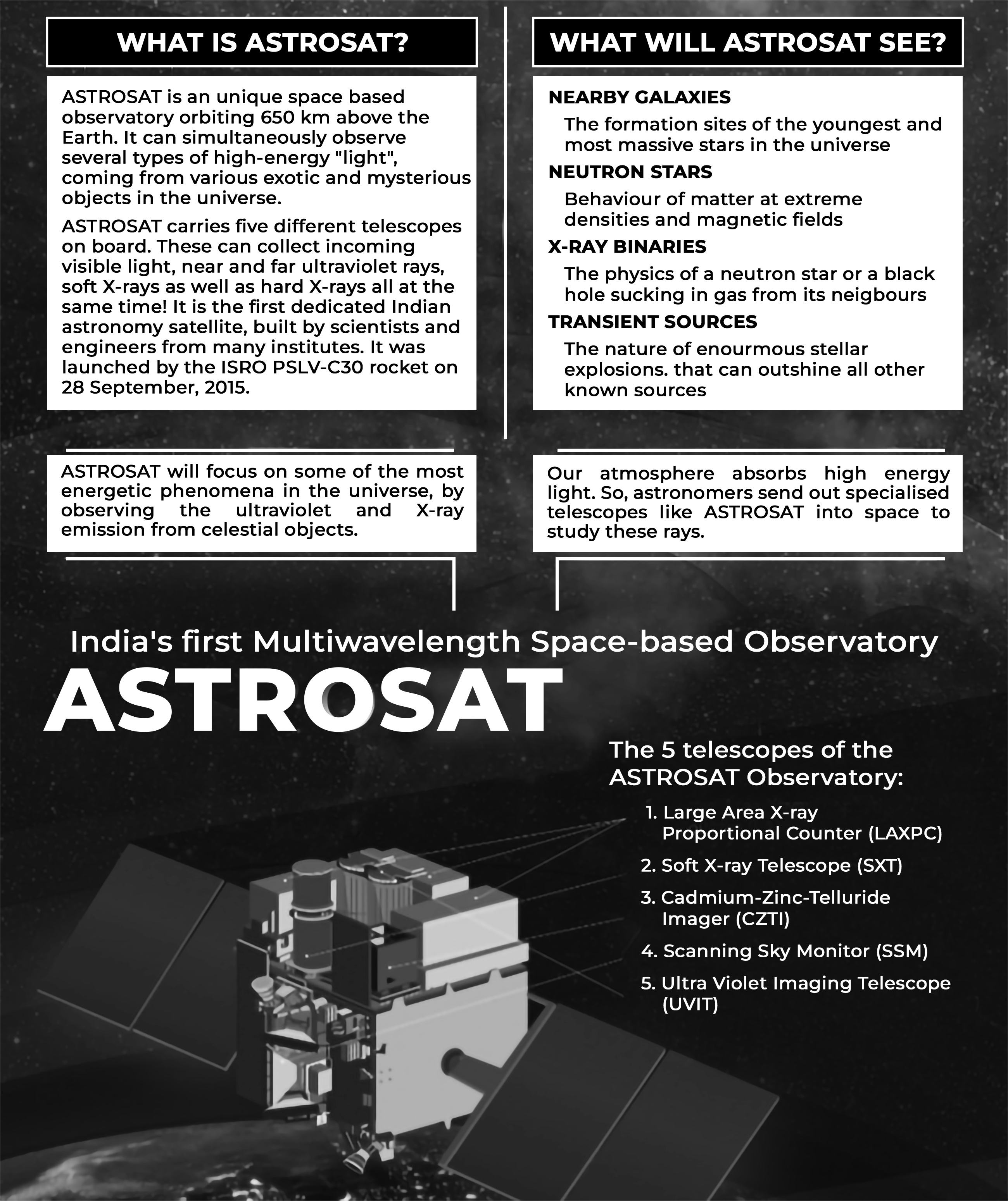
Gaganyaan Mission
Gaganyaan project envisages demonstration of human spaceflight capability by launching crew of 3 members to an orbit of 400 km for a 3 days mission and bring them back safely to earth, by landing in Indian sea waters.
The project is accomplished through an optimal strategy by considering inhouse expertise, experience of Indian industry, intellectual capabilities of Indian academia & research institutions along with cutting edge technologies available with international agencies. The pre-requisites for Gaganyaan mission include development of many critical technologies including human rated launch vehicle for carrying crew safely to space, Life Support System to provide an earth like environment to crew in space, crew emergency escape provision and evolving crew management aspects for training, recovery and rehabilitation of crew.
Various precursor missions are planned for demonstrating the Technology Preparedness Levels before carrying out the actual Human Space Flight mission. These demonstrator missions include Integrated Air Drop Test (IADT), Pad Abort Test (PAT) and Test Vehicle (TV) flights. Safety and reliability of all systems will be proven in unmanned missions preceding manned mission.
Human rated LVM3 - HLVM3
LVM3 rocket - The well proven and reliable heavy lift launcher of ISRO, is identified as the launch vehicle for Gaganyaan
mission. It consists of solid stage, liquid stage and cryogenic stage. All systems in LVM3 launch vehicle are re-configured to meet human rating requirements and christened Human Rated LVM3. HLVM3 will be capable of launching the Orbital Module to an intended Low Earth Orbit of 400 km.
HLVM3 consists of Crew Escape System (CES) powered by a set of quick acting, high burn rate solid motors which ensures that Crew Module along with crew is taken to a safe distance in case of any emergency either at launch pad or during ascent phase.
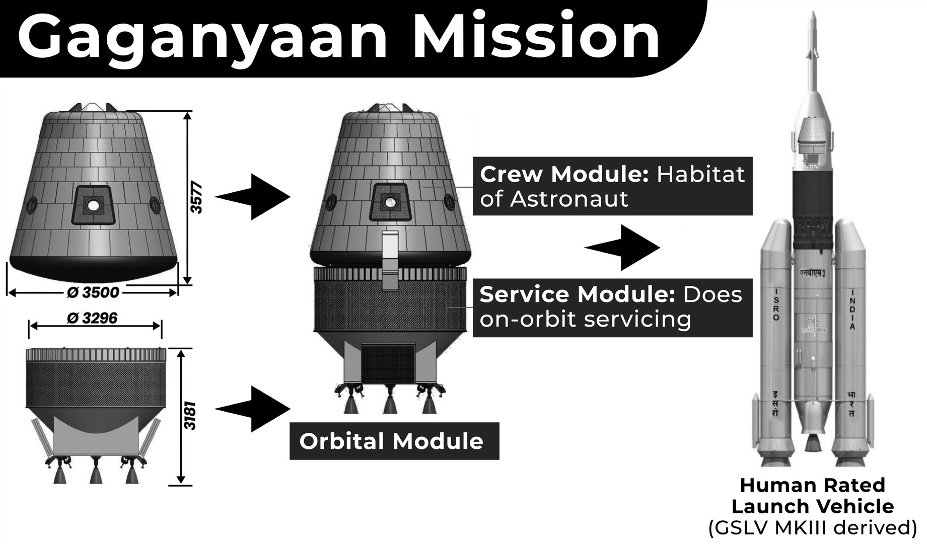
Orbital Module (OM)
Orbital Module (OM) that will be Orbiting Earth comprises of Crew Module (CM) and Service Module (SM). OM is equipped with state-of-the-art avionics systems with adequate redundancy considering human safety.
CM is the habitable space with Earth like environment in space for the crew. It is of double walled construction consisting of pressurized metallic Inner Structure and unpressurised External Structure with Thermal Protection System (TPS). It houses the crew interfaces, human centric products, life support system, avionics and deceleration systems. It is also designed for re-entry to ensure safety of the crew during descent till touchdown.
SM will be used for providing necessary support to CM while in orbit. It is an unpressurized structure containing thermal system, propulsion system, power systems, avionics systems and deployment mechanisms.
Crew training for Gaganyaan
Astronaut Training Facility established in Bengaluru caters to Classroom training, Physical Fitness training, Simulator training and Flight suit training. Training modules cover academic courses, Gaganyaan Flight Systems, Micro-gravity familiarization through Parabolic Flights, Aero-medical training, Recovery & Survival training, mastering of Flight Procedures and training on Crew Training Simulators. Aero medical training, Periodical flying practice and Yoga are also included as part of the training.
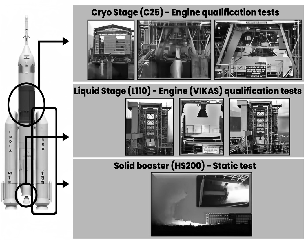
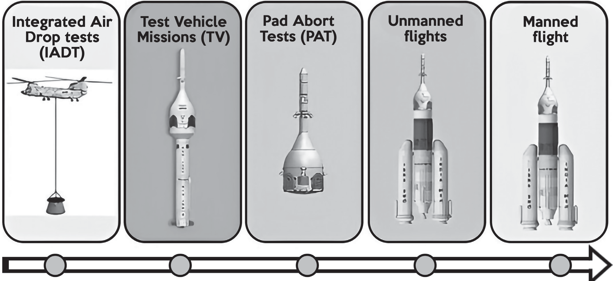
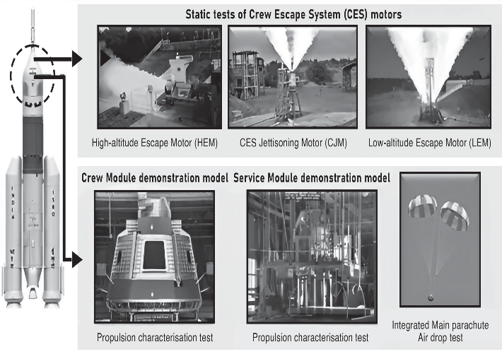
Aditya-L1 Mission
Aditya-L1 is a coronagraphy spacecraft designed and developed by the Indian Space Research Organisation (ISRO) and other Indian Space Research Institutes to study the solar atmosphere. Launched on September 2, 2023, it orbits 1.5 million km from Earth in a halo around Lagrange point 1 (L1) between Earth and the Sun. The first Indian mission dedicated to observing the Sun, Aditya-L1 will study solar atmosphere, solar magnetic storms, and their impact on Earth’s environment for nearly 5 years. Launched aboard PSLV C57, it successfully achieved its intended orbit and separated from its fourth stage. The Aditya-L1 is equipped with seven payloads (instruments) on board to study the Sun’s corona, solar emissions, solar winds and flares, and Coronal Mass Ejections (CMEs), and will carry out round-the-clock imaging of the Sun. The position is perfect for scientists to study the Sun without any blockage from the region.
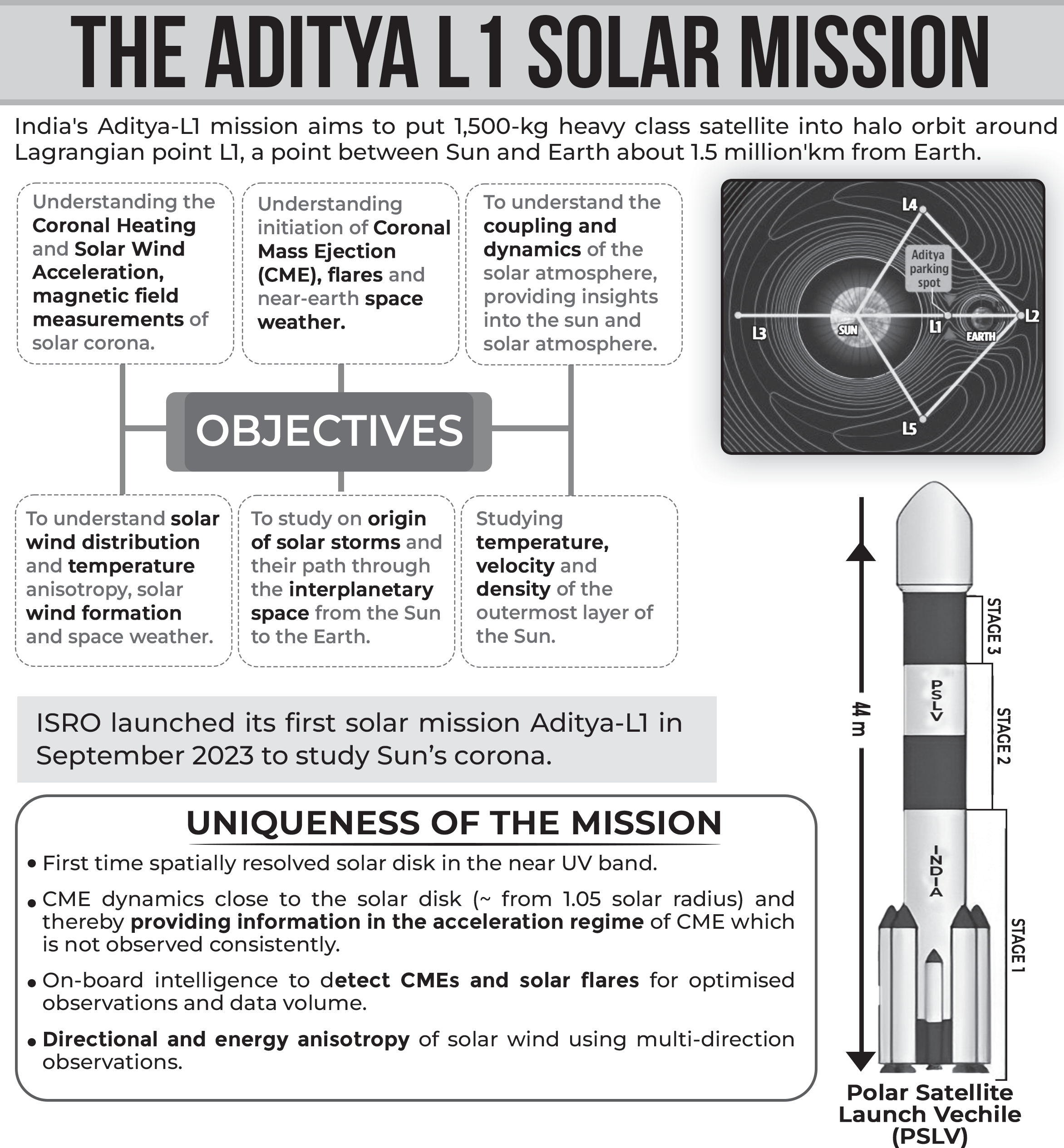
Objectives of the Mission
• As per ISRO, the mission’s objective includes understanding chromospheric and coronal heating, the physics of the partially ionized plasma, formation of the coronal mass ejections and flares.
• Understand the scientific reason behind solar corona and its heating mechanism.
• Calculate the Temperature, velocity, and density of the outermost layer of the Sun.
• Study various layers of the sun. Gather magnetic field measurements of the solar corona.
• Study the formation, and composition of solar wind and space weather.
• This mission will give us more details about the sun and the solar atmosphere which is affected by the sun’s activities
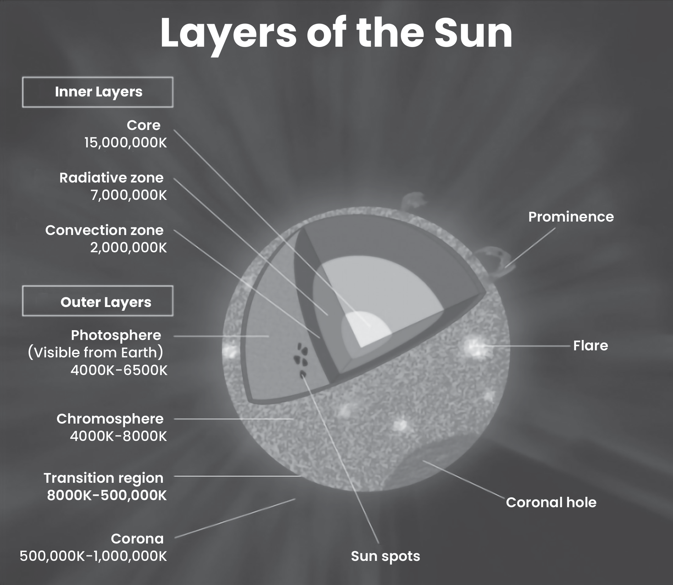
Significance of studying the Sun
• The solar weather and environment affect the weather of the entire solar system.
• Variations in this weather can change the orbits of satellites or shorten their lives, interfere with or damage onboard electronics, and cause power blackouts and other disturbances on Earth.
• Knowledge of solar events is key to understanding space weather.
• To learn about and track Earth-directed storms, and to predict their impact, continuous solar observations are needed.
• Every storm that emerges from the Sun and heads towards Earth passes through L1, and a satellite placed in the halo orbit around L1 of the Sun-Earth system has the major advantage of continuously viewing the Sun without any occultation/eclipses.
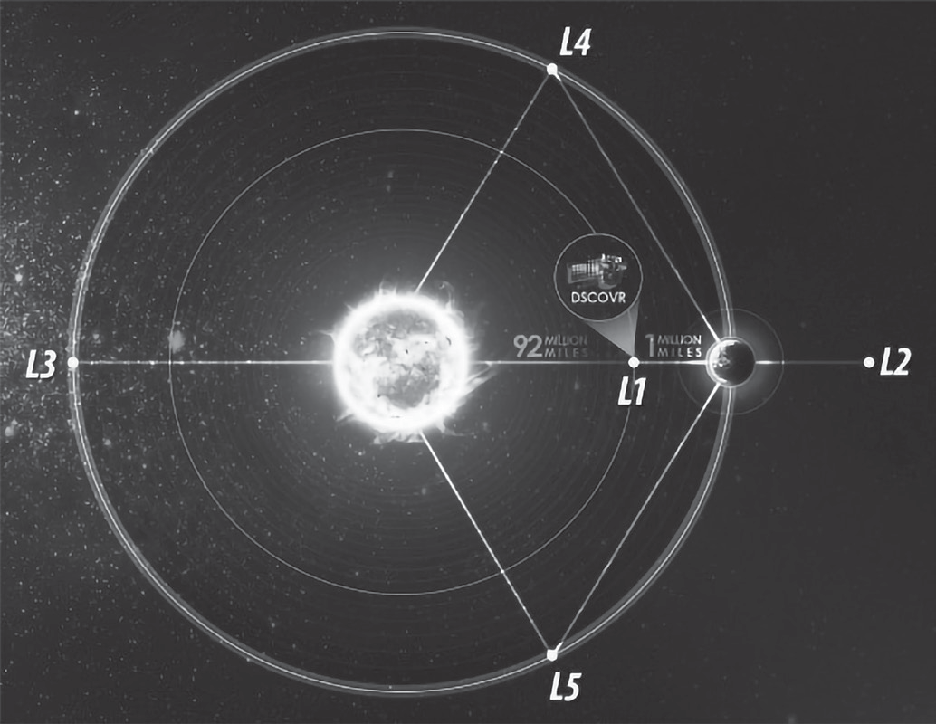
• L1 refers to Lagrangian/Lagrange Point 1, one of five points in the orbital plane of the Earth-Sun system.
• Lagrange Points, named after Italian-French mathematician Josephy-Louis Lagrange, are positions in space where the gravitational forces of a two-body system (like the Sun and the Earth) produce enhanced regions of attraction and repulsion.
• These can be used by spacecraft to reduce fuel consumption needed to remain in position
• The L1 point is home to the Solar and Heliospheric Observatory Satellite (SOHO), an international collaboration project of NASA and the European Space Agency (ESA).
• The L1 point is about 1.5 million km from Earth, or about one-hundredth of the way to the Sun.
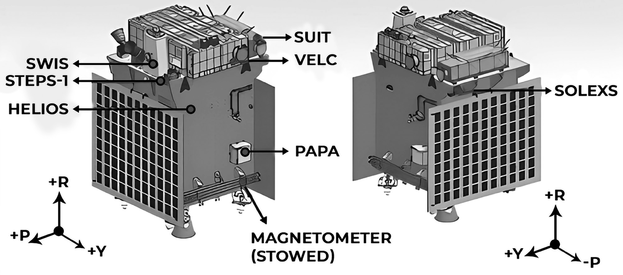
Shukrayaan-1 – Venus Exploration Mission
The name ‘Shukrayaan-1’ is a combination of two words ‘Shukra’, meaning Venus, and ‘Yaana’, meaning craft, in Sanskrit. The idea of ‘Shukrayaan-1’ was born in 2012. In that year, the ISRO sought payload proposals from research institutes. The primary objective of the mission is to conduct a comprehensive study of Venus, often referred to as “Earth’s twin.” This includes examining both the surface and atmosphere of Venus, as well as analyzing its geological composition. NASA has expressed doubt about the possibility of life on Venus at this time. Nonetheless, some scientists have not ruled out the potential existence of microbes in the upper atmosphere of Venus, where the pressure is more akin to Earth’s surface. Shukrayaan-1 seems to be progressing, but ISRO has not yet disclosed important details such as the launch date and other key aspects of the project.
Recent missions to Venus include European Space Agency’s Venus Express, which orbited the planet from 2006 until 2016, and Japan’s Akatsuki Venus Climate Orbiter, which has been in orbit since 2016. Additionally, NASA’s Parker Solar Probe has conducted multiple flybys of Venus. In February 2022, NASA announced that the spacecraft had successfully captured its first visible light images of Venus’ surface during its flyby in February 2021.
Radar Imaging Satellite (RISAT)
The Radar Imaging Satellite (RISAT) series is designed to provide all-weather surveillance with synthetic aperture radar for agricultural, forestry, and disaster management applications.
XPOSAT – X-ray Polarimetry Satellite
XPoSat (X-ray Polarimeter Satellite) is India’s first dedicated polarimetry mission to study various dynamics of bright astronomical X-ray sources in extreme conditions. The spacecraft will carry two scientific payloads, POLIX measuring polarimetry parameters in the medium X-ray energy range of 8-30 keV photons, and XSPECT providing spectroscopic information in the energy range of 0.8-15 keV. The emission mechanisms from astronomical sources, such as blackholes, neutron stars, active galactic nuclei, and pulsar wind nebulae, are complex and challenging to understand. Polarimetry measurements add dimension to our understanding, such as the degree and angle of polarization, making them an excellent diagnostic tool. The polarimetric observations and spectroscopic measurements are expected to break the degeneracy of various theoretical models of astronomical emission processes, and this will be the major direction of research from XPoSat by the Indian science community.
XPoSat payloads-
• POLIX: POLIX is an X-ray Polarimeter designed for astronomical observations in the 8-30 keV energy band. It is developed by the Ramam Research Institute (RRI) in collaboration with U R Rao Satellite Centre (URSC). The instrument consists of a collimator, scatterer, and four X-ray proportional counter detectors. The scatterer is made of low atomic mass material, causing anisotropic Thomson scattering of incoming polarised X-rays. The collimator restricts the field of view to 3 degree x 3
degree, allowing only one bright source for most observations. POLIX is the first payload in the medium X-ray energy
band dedicated for polarimetry measurements.
XSPECT: XSPECT is an X-ray SPECtroscopy and Timing payload onboard XPoSat, providing fast timing and good spectroscopic resolution in soft X-rays. It can monitor spectral state changes in continuum emission, line flux, and profile, and temporal soft X-ray emission in the X-ray energy range of 0.8-15 keV. An array of Swept Charge Devices (SCDs) provides an effective area of over 30 cm2 at 6 keV with energy resolution better than 200 eV at 6 keV. Passive collimators narrow the field of view. XSPECT observes various sources, including X-ray pulsars, blackhole binaries, low-magnetic field neutron stars, AGNs and magnetars
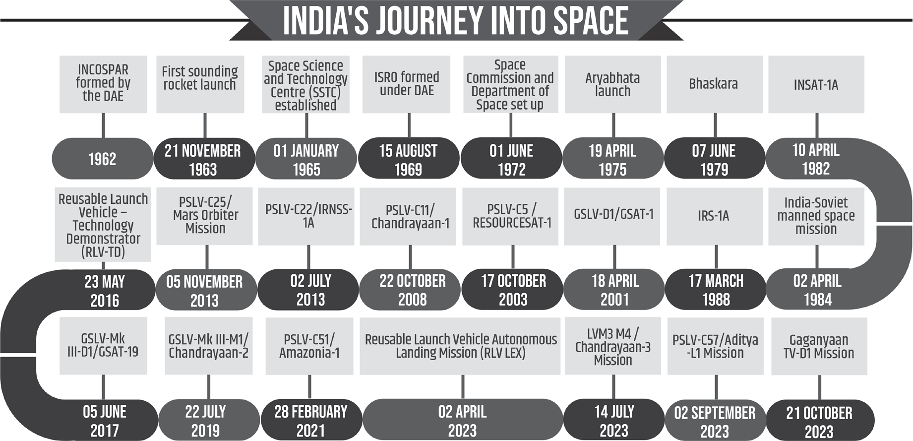
International Space Station
INTERNATIONAL SPACE STATION
• The International Space Station is a large spacecraft in orbit around Earth. It serves as a home where crews of astronauts and cosmonauts live.
• It is a collaborative project of the United States (NASA), Europe’s (ESA), Russia’s (Roscosmos), Japan’s (JAXA), and Canada’s (CSA) space agencies.
• The space station is also a unique science laboratory. Several nations worked together to build and use the space station.
• The first parts of the ISS were sent and assembled in orbit in 1998. Since the year 2000, the ISS has had crews living continuously on board.
• It travels at 28163.52 kph. This means it orbits Earth
every 90 minutes.
• The ISS orbits between 370 and 460 kilometers (230–286 miles) above Earth’s surface. The average distance is similar to the distance between Washington, DC, and
New York, NY.
• The ISS orbits at a 51.6-degree inclination around Earth. This angle covers 90 percent of the populated area of Earth.
Types of experiments conducted on International Space Station (ISS)
• Studies on how living in space affects the human body.
Technology demonstrations for future human spaceflight equipment, including experience gained from current operational systems.
• Physical science experiments that benefit from the
station’s weightless environment
• Earth science and astrophysics instruments that use the station as an orbital platform.
Important discoveries of International Space Station (ISS)
• Fundamental disease research: Space station research has significantly impacted various diseases, including Alzheimer’s, Parkinson’s, cancer, asthma and heart disease, by providing new insights and developing diagnostic tools for spaceflight and Earth applications.
• New water purification systems: The JEM Water Recovery System (JWRS) efficiently recycles wastewater on space stations, reducing resupply missions and ensuring potable water supply for long-term space missions.
• Methods to combat muscle atrophy and bone loss: Space studies reveal astronauts’ bone and muscle loss, affecting both astronauts in space and people on earth dealing with the diseases such as osteoporosis. Researchers develop exercise and diet regimens to mitigate these effects.
• Growing food in microgravity: Space station explores plant growth techniques for astronauts’ exploration, preparing for microgravity missions. Tests on watering, lighting and plant conditions are ongoing.
• Exploring the fifth state of matter: Around 25 years ago, scientists first produced a fifth state of matter, called a Bose- Einstein condensate (BEC), on Earth. In 2018, NASA’s Cold Atom Lab became the first facility to produce that state of matter in space. This achievement may provide insight into fundamental laws of quantum mechanics.
• Stimulating the low-Earth orbit economy: From satellite deployment to in-space research, a vibrant commercial space economy has developed, with a value that now exceeds $345 billion. The space station has been a key part of supporting that growth.
Other countries mission
China built and runs the Tiangong space station, a permanently manned space station in low Earth orbit, which was launched in 2021 by the China Manned Space Agency.
• Russia decided in 2022 to stop using the International Space Station after 2024 in order to concentrate on developing its own space station.
• By 2035, India intends to launch its own space station, which would weigh 20 tonnes and keep an orbit 400 kilometres above Earth, long enough for astronauts to spend 15 to 20 days there.
• A cooperative mission to the International Space Station in 2024 has been agreed upon by NASA and ISRO.
Space History
SPACE HISTORY

United Nations Office for Outer Space Affairs
UNITED NATIONS OFFICE FOR OUTER SPACE AFFAIRS (UNOOSA)
The United Nations Office for Outer Space Affairs (UNOOSA) promotes international cooperation in peaceful space exploration and sustainable economic and social development. It assists Member States in establishing legal frameworks for space activities and strengthens developing countries’ capacity to use space science technology by integrating space capabilities into national development programs.
UNOOSA is the secretariat for the United Nations “Committee on the Peaceful Uses of Outer Space” (COPUOS), which focuses on inter cooperation in the peaceful uses of outer space. UNOOSA conducts international workshops, training courses, and pilot projects on satellite navigation, meteorology, remote sensing, tele-education, and basic space sciences for developing nations through the United Nations Programme on Space Applications.
UNOOSA promotes international cooperation in the peaceful uses of outer space and manages the United Nations Platform for Space-based Information for Disaster Management and Emergency Response (UN-SPIDER) during disasters. It also prepares and distributes reports, studies, and publications on various fields of space science and technology applications and those related to international space law. UNOOSA is located at the United Nations Office in Vienna, Austria
Space Law
SPACE LAW
Space law is the body of international law governing space- related activities, including international agreements, treaties, conventions, and resolutions of the United Nations General Assembly. It encompasses rules, principles, and standards developed under the United Nations’ auspices, as well as national legislation.
Space law addresses various matters, such as preserving the space and Earth environment, settling disputes, rescuing astronauts, sharing information about potential dangers in outer space, using space-related technologies, and international cooperation. Fundamental principles guide space activities, including the notion of space as the province of all humankind, freedom of exploration and use without discrimination, and the principle of non-appropriation of outer space. The Office provides information and advice to governments, non-governmental organizations, and the general public on space law to promote understanding, acceptance, and implementation of international space law agreements.
Space Law in India
Space Law in India
An international dispute arose after debris from an Indian satellite landed on a Japanese fishing village and a failed rocket launch destroyed a dozen satellites. In 2020, the Indian Government introduced space domain reforms, allowing enhanced participation of Non-Governmental Entities (NGEs) in end-to-end activities. The government aims to provide regulatory certainty to space activities by various stakeholders to create a thriving space ecosystem. The reforms aim to ensure a level playing field for NGEs in the space domain.
Indian Space Policy - 2023
The Government of India unleashed reforms in space domain in 2020, opening the doors for enhanced participation of Non- Governmental Entities (NGEs) in carrying out end-to-end activities in the space domain and with an aim to provide them a level playing field. Subsequent to these reforms, the Government seeks to provide regulatory certainty to space activities by various stakeholders, in order to create a thriving space ecosystem. The Indian Space Policy – 2023 has thus been formulated as an overarching, composite and dynamic framework to implement the reform vision approved by Cabinet.
Vision
The goal is to enhance space capabilities, promote commercial presence in space, drive technology development, foster international relations, and create an ecosystem for space applications.
This will benefit the nation’s socio-economic development, security, environment protection, peaceful exploration, public awareness, and scientific research, while also promoting international relations.
Significance
The policy aims to establish space industry standards, promote specific space activities, and collaborate with academia to expand the space ecosystem.
ISRO’s primary focus is on research into outer space, resulting in advanced technologies and applications.
The policy aims to increase India’s space capabilities, promote commercial existence in space, drive technology evolution, maintain international relations, and build an ecosystem for space applications among stakeholders.
Space Debris
SPACE DEBRIS
Space debris encompasses both natural (meteoroid) and artificial (man-made) particles. Meteoroids are in orbit about the sun, while most artificial debris is in orbit about the Earth which is commonly referred to as orbital debris. Much of the debris is in low Earth orbit (LEO), though some debris can be found in geostationary orbit. There are about 500,000 pieces of debris the size of a marble or larger orbiting the Earth, travelling at speeds up to 17,500 mph. International guidelines suggest removing space crafts from LEO within 25 years of the end of their mission. However, only 60 percent of missions follow the guidelines.
Tackling Space Debris
Mitigating Damage: Space debris is tracked by a number of countries, including Germany, France, UK and USA
• ISRO has come up with ‘Project NETRA’ - an early warning system in space to detect debris and other hazards to Indian satellites
• Indraprastha Institute of Information Technology Delhi is working on a project titled “Orbit computation of Resident Space Objects for Space Situational Awareness” to predict collision from space debris.
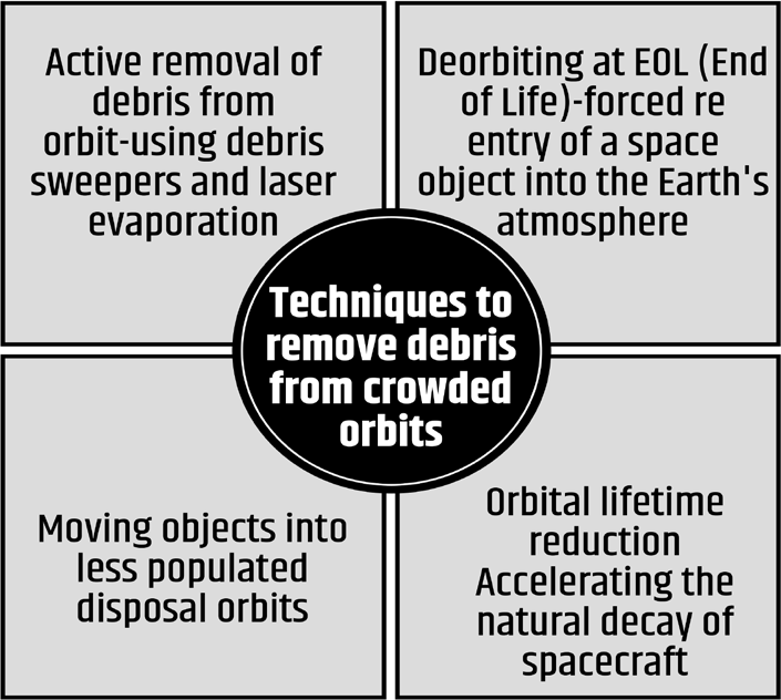
• Avoiding future debris: by adopting better designs of rockets and other objects. For example, making rockets reusable could vastly cut down waste
• UK’s TechDemoSat-1 (TDS-1), was designed in such a way that once its mission is over, a system, would drag the satellite to re-enter the atmosphere and burn up
• Removal of the debris-
End-of-Life Services by Astroscale Demonstration (Elsa-D) was launched to locate and retrieve used satellites and other space junk
Remove Debris is an EU research project to give in orbit demonstrations of cost-effective technologies that can be used to observe, capture and dispose of space debris.
It has performed key technology demonstrations including: Net Capture, Harpoon Capture
• Kumotori Experiment (White Stork JEXA): Use of tether to attach space junk magnetic tether once tethered, it will be pulled down to atmosphere and burnt out by air friction. Japan tried it in 2017, but the experiment failed.
• Remove Debris Project: Harpoon Satellite to catch debris (net capture - of space debris)
• Providing high thrust and escape velocity to send to outer universe
• Production of Satellite that do not produce debris - Ex. RLV even satellites need to be reusable.
• UNOOSA: UN office on outer space activities was set up committee to investigate space debris
• Space debris with large speed are the most dangerous as there is maximum chance of collisions

Kessler Syndrome
The Kessler Syndrome is a phenomenon in which the amount of junk in orbit around Earth reaches a point where it just creates more and more space debris, causing big problems for satellites, astronauts and mission planners.
Consider this scenario: The destruction of a dead spy satellite spawns a swarm of debris in Earth orbit, which wreaks ever- increasing havoc as it zooms around our planet.
The cloud destroys a number of communications satellites, generating more and more debris with every violent collision. It takes out the iconic Hubble Space Telescope and a NASA space shuttle, killing several crewmembers aboard the winged vehicle. It then lines the International Space Station (ISS) up in its crosshairs, destroying the $100 billion orbiting lab with a hail of fast-flying shrapnel.
This dramatic scene is fictional, of course; it’s pulled from the award-winning 2013 sci-fi film “Gravity.” But many satellite operators, mission planners and exploration advocates worry that it could be a dark window into a future that’s all too real, thanks to the Kessler Syndrome.
Problems Faced by Astronauts in Space
SPACE DEBRIS
Space debris encompasses both natural (meteoroid) and artificial (man-made) particles. Meteoroids are in orbit about the sun, while most artificial debris is in orbit about the Earth which is commonly referred to as orbital debris. Much of the debris is in low Earth orbit (LEO), though some debris can be found in geostationary orbit. There are about 500,000 pieces of debris the size of a marble or larger orbiting the Earth, travelling at speeds up to 17,500 mph. International guidelines suggest removing space crafts from LEO within 25 years of the end of their mission. However, only 60 percent of missions follow the guidelines.
Tackling Space Debris
Mitigating Damage: Space debris is tracked by a number of countries, including Germany, France, UK and USA
• ISRO has come up with ‘Project NETRA’ - an early warning system in space to detect debris and other hazards to Indian satellites
• Indraprastha Institute of Information Technology Delhi is working on a project titled “Orbit computation of Resident Space Objects for Space Situational Awareness” to predict collision from space debris.
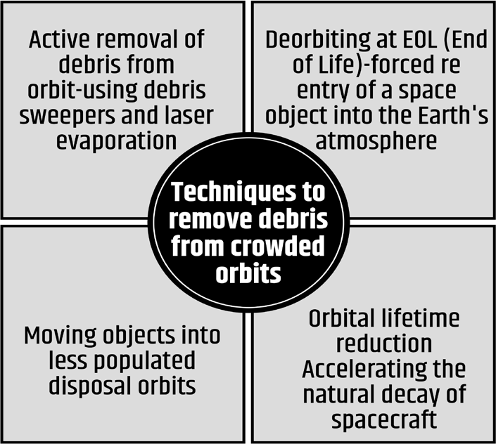
• Avoiding future debris: by adopting better designs of rockets and other objects. For example, making rockets reusable could vastly cut down waste
• UK’s TechDemoSat-1 (TDS-1), was designed in such a way that once its mission is over, a system, would drag the satellite to re-enter the atmosphere and burn up
• Removal of the debris-
End-of-Life Services by Astroscale Demonstration (Elsa-D) was launched to locate and retrieve used satellites and other space junk
Remove Debris is an EU research project to give in orbit demonstrations of cost-effective technologies that can be used to observe, capture and dispose of space debris.
It has performed key technology demonstrations including: Net Capture, Harpoon Capture
• Kumotori Experiment (White Stork JEXA): Use of tether to attach space junk magnetic tether once tethered, it will be pulled down to atmosphere and burnt out by air friction. Japan tried it in 2017, but the experiment failed.
• Remove Debris Project: Harpoon Satellite to catch debris (net capture - of space debris)
• Providing high thrust and escape velocity to send to outer universe
• Production of Satellite that do not produce debris - Ex. RLV even satellites need to be reusable.
• UNOOSA: UN office on outer space activities was set up committee to investigate space debris
• Space debris with large speed are the most dangerous as there is maximum chance of collisions
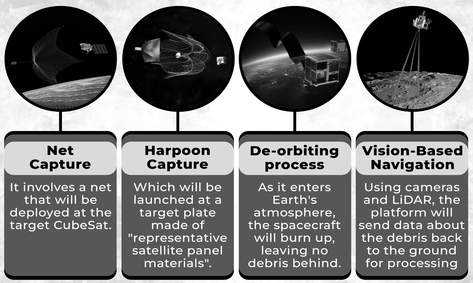
Kessler Syndrome
The Kessler Syndrome is a phenomenon in which the amount of junk in orbit around Earth reaches a point where it just creates more and more space debris, causing big problems for satellites, astronauts and mission planners.
Consider this scenario: The destruction of a dead spy satellite spawns a swarm of debris in Earth orbit, which wreaks ever- increasing havoc as it zooms around our planet.
The cloud destroys a number of communications satellites, generating more and more debris with every violent collision. It takes out the iconic Hubble Space Telescope and a NASA space shuttle, killing several crewmembers aboard the winged vehicle. It then lines the International Space Station (ISS) up in its crosshairs, destroying the $100 billion orbiting lab with a hail of fast-flying shrapnel.
This dramatic scene is fictional, of course; it’s pulled from the award-winning 2013 sci-fi film “Gravity.” But many satellite operators, mission planners and exploration advocates worry that it could be a dark window into a future that’s all too real, thanks to the Kessler Syndrome.
Indian Astronauts and Their Achievements
INDIAN ASTRONAUTS AND THEIR ACHIEVEMENTS
Rakesh Sharma, The First Indian To Make It To Space
During a Soviet-Indian space mission, Patiala, Punjab-born cosmonaut and military pilot Rakesh Sharma spent eight days aboard the Soyuz 7 orbital station. He carried out experiments, one of which examined the impact of yoga on the body while it is weightless. Yoga has been shown to be beneficial in reducing stress, anxiety and mental unrest while also enhancing general health and cognitive function. For astronauts, students, athletes and everyday individuals looking to decompress from their daily problems and worries, this is essential. While other Indian astronauts have taken part in comparable missions, Sharma is the only Indian citizen to have ever flown in space. Sharma quoted a national poet in response to a question concerning how India seemed from space, saying that it appeared “better than the world.”
Kalpana Chawala, the First Indian Woman To Fly To Space
In 1997, Kalpana, an Indian-American engineer and astronaut, became the first woman of Indian descent to fly into space. She performed the roles of robot arm operator and mission expert. She made another space flight in 2003, but sadly, the spacecraft disintegrated as it was returning to Earth’s atmosphere, taking her life along with six others.
Sunita Williams Holds The Record For The Most Spacewalks By A Woman with Indian Origins
Sunita Williams, a US Navy officer with Indian origins, holds the record for the most spacewalks completed by a woman with Indian origins and the longest time spent on a spacewalk for an Indian woman. Born in Ohio, she joined the International Space Station as a crew member during Expeditions 14 and 15, and later served as a flight engineer and commander on Expedition 32. Sunita’s journey into space has been a testament to her dedication and perseverance.
Raja Chari is the Fourth Indian who will go to Space
Raja, a graduate of the US Air Force Academy, MIT, and the US Naval Test Pilot School, was selected for the Astronaut Candidate Class in 2017. His qualifications and testing scores made him the only Indian-American to join the list of 18 handpicked Moon goers by NASA. Raja would be the fourth Indian-American astronaut to make it into space, and his mission will make him one of the most noteworthy and honourable people in the country. He and the other 17 astronauts who joined the Artemis Program are hoping to fly to the Moon by 2024.
Group Captain Shubhanshu Shukla of the Indian Air Force (IAF) became the second Indian to travel to outer space after Rakesh sharma in and the first to visit the ISS in 2025 under the Axiom mission-4
Some Important International Space Missions
Some Important International Space Missions
| Celestial Body | Mission | Organization |
| Jupite | Orbiter Missions | |
| Galileo (1995-2003) | NASA | |
| Juno (2016) | NASA | |
| Jupiter Icy Moon Explore (2023) | European Space Agency | |
| Flyby Missions | ||
| Pioneer programme (1973 and 1974) | NASA | |
| Voyager programme (1979) | NASA | |
| Ulysses (1992) | European Space Agency and NASA | |
| Cassini (2000) | NASA | |
| New Horizons (2007) | NASA | |
| Saturn | CASSINI-HUYGENS (Orbiter – Cassini and Lander – Huygens) (1997) | NASA, European Space Agency and Italian Space Agency |
| Titan Saturn System Mission (TSSM) to be launched between 2020-2029 | NASA and European Space Agency | |
| Dragonfly (2027) | NASA | |
| Mars | Mars Odyssey (2001) | NASA |
| Mars Express (2003) | European Space Agency | |
| Mangalyaan (Mars Orbiter Mission) (2013) | Indian Space Research Organisation (ISRO) | |
| MAVEN (2013) | NASA | |
| InSight Lander (2018) | NASA | |
| Hope Mars Mission (2020) | UAE Space Agency | |
| Perseverance Rover (2020) | NASA | |
| Tianwen-1 (2020) | China National Space Agency | |
| Mercury | Mariner 10 (1973) | NASA |
| Messenger (2004) | NASA | |
| BepiColombo (2018) | European Space Agency and the Japan Aerospace Exploration Agency | |
| Sun | Pioneer 5 (1960) | NASA |
| Helios A (1974) | German Aerospace Center and NASA | |
| Parker Solar Probe (2018-2025) | NASA | |
| Genesis (2001) | NASA | |
| Solar Orbiter (2020) | European Space Agency and NASA | |
| Aditya-L1 (2023) | Indian Space Research Organization (ISRO) |