SATELLITES AND THEIR ORBITS
On the basis of distance from Earth
Low Earth Orbit (LEO)
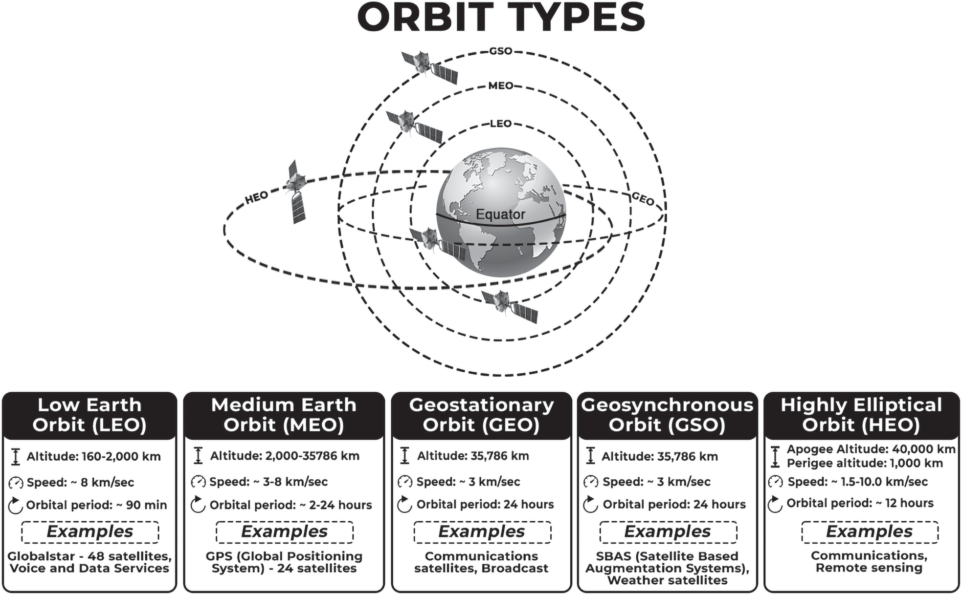
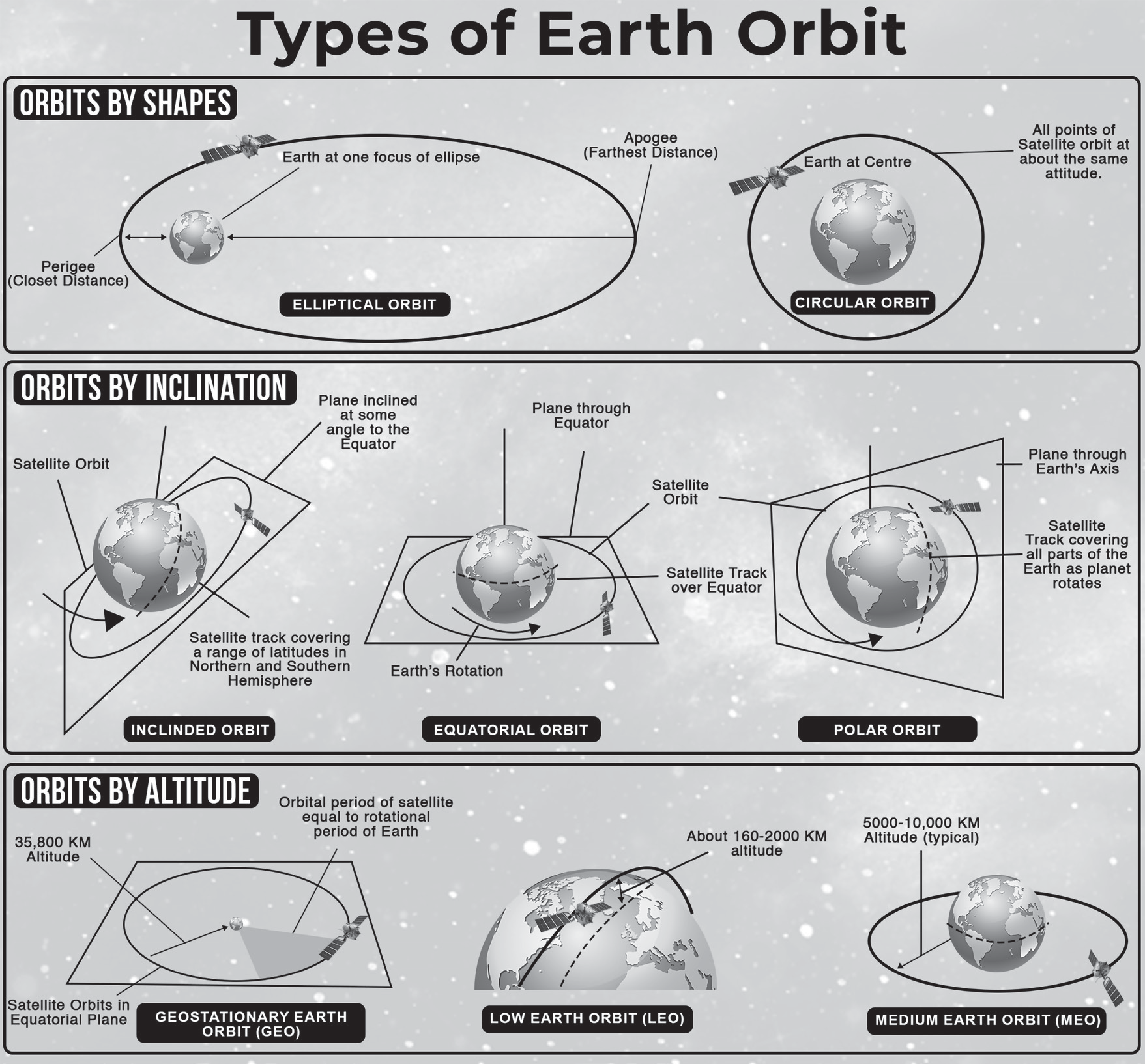
A low Earth orbit (LEO) is an orbit close to Earth’s surface, typically at an altitude of less than 2000 km but potentially as low as 160 km. This is significantly higher than most commercial aeroplanes, which typically fly at altitudes around 14 km. LEO satellites can be tilted, unlike those in GEO, which must always orbit along Earth’s equator. This allows for more available routes for satellites, making LEO a popular orbit for satellites.
LEO’s proximity to Earth makes it a popular orbit for satellite imaging and the International Space Station (ISS). It allows for higher resolution images and shorter travel distances for astronauts. Satellites in this orbit travel
at 7.8 km per second, taking 90 minutes to circle Earth, resulting in the ISS traveling around Earth 16 times a day. However, individual LEO satellites are less useful for tasks like telecommunication due to their fast movement across the sky and the effort required to track them from ground stations.
Medium Earth Orbit (MEO)
Medium Earth Orbit (MEO) occupies the area between LEO and HEO, orbiting at altitudes ranging from 2,000 km to 35,786 km.
While the boundary between MEO and LEO is arbitrary, the 35,786 km limit is carefully determined since it is the altitude above sea level that a satellite must reach to achieve a geosynchronous orbit. MEO satellites are typically larger than those in low Earth orbit, taking between two and twenty-four hours to complete a full orbit around the Earth.
With these slower trip periods, it is necessary that MEO satellites are physically larger to accommodate more powerful communications equipment and data capacity. Satellites in the MEO
GPS (Global Positioning System) or NAVSTAR
GLONASS (Global Navigation and satellite system of Russia)
GALILEO (European union)
BEIDOU-1 (China’s regional navigation in Central Asia)
BEIDOU- 2 (China’s global navigation system)
NAVIC - IRNSS (India’s Regional positioning system)
QZSS (Regional System of Japan)
High Earth Orbit (HEO)
High Earth Orbit (HEO) is the region of Earth’s orbit where objects take more than a day to complete a rotation. It is located anywhere over 35,786 km above sea level. While satellites closer to this border will keep their orbits in sync with Earth’s rotation, those farther away may require many days or even weeks to finish their orbits.
Being so far out, satellites in a HEO configuration are large, powerful installations, relaying the most powerful signals from one place on Earth to another. TV signals, satellite internet and space telescopes are all examples of the services often provided by satellites in an HEO configuration.
On the Basis of utility
Geosynchronous Orbits
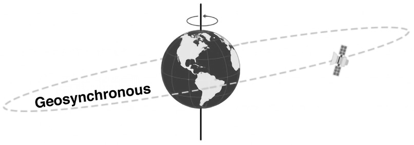
Geo + sync = satellites that are in sync with the rotation of the earth i.e., they take the same time earth takes rotate. There’s a sweet spot above the Earth where a satellite can match the same rotation of the Earth. This special position in high Earth orbit is known as a geosynchronous orbit and it is 35,786 km from the earth. At any inclination, a geosynchronous orbit synchronizes with the rotation of the Earth. More specifically, the time it takes for the Earth to rotate on its axis is 23 hours, 56 minutes, and 4.09 seconds, which is the same as a satellite in a geosynchronous orbit. It is in sync with the earth, but for an observer on the earth, they will appear to move up (north) and down (south) on the horizon.
Geostationary Orbits

They are a type of geosynchronous orbits. While geosynchronous satellites can have any inclination, the key difference from geostationary orbit is the fact that they lie on the same plane as the equator. Geostationary orbits fall in the same category as geosynchronous orbits, but it’s parked over the equator. This one special quality makes it unique from geosynchronous orbits. If you are an observer on the ground, you would see the satellite as if it’s in a fixed position without movement.
Thus, all geostationary satellites are geosynchronous but not vice versa. While both lie on the same plane as the equator, the geosynchronous satellites have a different inclination.
This makes geosynchronous satellites particularly useful for telecommunications and other remote sensing applications.

Polar Orbits
Satellites in polar orbits usually travel past Earth from north to south rather than from west to east, passing roughly over Earth’s poles. These types of satellites observe the entire earth in a day.

Satellites in a polar orbit do not have to pass the North and South Pole precisely; even a deviation within 20 to 30 degrees is still classed as a polar orbit. Polar orbits are a type of low Earth orbit, as they are at low altitudes between 200 to 1000 km.
Sun-synchronous orbit (SSO) is a particular kind of polar orbit. Satellites in SSO, travelling over the polar regions, are synchronous with the Sun. This means they are synchronised to always be in the same ‘fixed’ position relative to the Sun. This means that the satellite always visits the same spot at the same local time – for example, passing the city of Paris every day at noon exactly.
This means that the satellite will always observe a point on the Earth as if constantly at the same time of the day, which serves a number of applications; for example, it means that scientists and those who use the satellite images can compare how somewhere changes over time.
This is because, if you want to monitor an area by taking a series of images of a certain place across many days, weeks, months, or even years, then it would not be very helpful to compare somewhere at midnight and then at midday – you need to take each picture as similarly as the previous picture as possible. Therefore, scientists use image series like these to investigate how weather patterns emerge, to help predict weather or storms; when monitoring emergencies like forest fires or flooding; or to accumulate data on long-term problems like deforestation or rising sea levels.
Often, satellites in SSO are synchronised so that they are in constant dawn or dusk – this is because by constantly riding a sunset or sunrise, they will never have the Sun at an angle where the Earth shadows them. A satellite in a Sun- synchronous orbit would usually be at an altitude of between 600 to 800 km. At 800 km, it will be travelling at a speed of approximately 7.5 km per second. These are also known as Sun Synchronous Orbit.
NAVSTAR or GPS
GPS is a navigation system that uses satellites to determine the location of a GPS receiver on or near Earth’s surface. Owned by the United States government, it consists of three main segments: the Space Segment, Control Segment, and User Segment. The Space Segment consists of at least 31 satellites, 24 of which are operational and orbit Earth at an altitude of 12,550 miles. The User Segment is for civilians and GPS receivers, who receive signals from these satellites to pinpoint their locations. GPS works through trilateration, where GPS receivers listen to signals from at least four satellites and calculate the distance between them. GPS location services have Standard Positioning (SPS) as an approximate system, while Restricted Positioning (RPS) is accurate and precise. SPS is used in civil applications, while RPS is used in military ones.
NAVIC- IRNSS
NAVIC stands for Navigation with Indian Constellation. It was previously known as Indian Regional Navigation Satellite System (IRNSS). It has 7 satellites-
4 Satellites (Geosynchronous)
3 Satellites (Geostationary 36,000 km)
Coverage: India + 1500 Km from Border
Resolution (10 meters)
All of the satellites have been placed
Forthcoming change: To add the L1 Spectrum band into NavIC which is part of GPS and is the most used for civilian navigational use.
The Government of India is pushing smartphone makers to enable support for its NavIC navigation system in new devices from next year. NavIC is an independent stand- alone navigation satellite system
Expansion will help to increase its use in civilian sector and ships, aircraft travelling far from the country’s borders
Application: Public vehicle tracking in India, providing emergency warning alerts to fishermen, tracking and providing information related to natural disasters